Galveston Bay: Difference between revisions
| Line 180: | Line 180: | ||
File:Projected land use.jpg|''Projected land use: following rising sea levels and extensive urbanization and industrialization of coastline and surrounding land.'' | File:Projected land use.jpg|''Projected land use: following rising sea levels and extensive urbanization and industrialization of coastline and surrounding land.'' | ||
File:Ecosystem services gb.jpg|''Ecosystem services, Galveston Bay:'' ''Provisioning: Grains, Cotton, Silage, Hay, Fish, Beef.'' ''Supporting: Nutrient cycles, Stormwater and erosion control.'' ''Cultural: Recreation and Education'' | File:Ecosystem services gb.jpg|''Ecosystem services, Galveston Bay:'' ''Provisioning: Grains, Cotton, Silage, Hay, Fish, Beef.'' ''Supporting: Nutrient cycles, Stormwater and erosion control.'' ''Cultural: Recreation and Education'' | ||
File: | File:Threats gb.jpg|''Threats posed to Galveston Bay.'' | ||
</gallery> | </gallery> | ||
Revision as of 21:04, 16 May 2018
>>>back to working groups overview
| Area | Galveston Bay | |
| Place | Galveston, Texas | |
| Country | USA | |
| Topics | Nature Protection | |
| Author(s) | Margaret Weber | |

| ||
Rationale
Galveston Bay is the seventh largest estuary in the United States and houses three trans-Atlantic ports, one of which is the second most productive port in the United States. It is bordered to the west by the fifth largest metropolitan area in the nation and is affected heavily by stormwater runoff and pollution from both the urban and industrial areas upstream and on its shores. Heavy tropical storms batter its coastlines and barrier islands to the south. Although it is highly productive as an industrial area, the health of the ecosystems found within it are in question. The unique composition of the barrier islands, salt water marshes and shallow water creates a plethora of aquatic and terrestrial ecosystems unique to this bay that must be protected as the area becomes more developed and storms increase in magnitude.
Location and scope
You can edit this map with the map editor
A Landscape System Analysis
A.1 Landscape layers and their system context
Geomorphology, landscape units and coastal typology
- Description of evolution, status quo and driving forces, is the coastal typology changing? Why is that? (approx 200 signs)
The landscape is comprised of flat grass marshes, prairies, lagoons and brackish ponds, shoals, and sand beaches. It has been settled and rapidly urbanized with piers, road infrastructure, residential houses, industrial factories, hotels and harbors of various sizes. The inner bay is protected from the Gulf of Mexico by the barrier island which has been built up over millions of years by Pleistocene sediments, marine mud, sand, and degraded shells. Land degradation is common here, not only from rapid urbanization and industrial pollution, but also from erosion caused by tides and strong tropical storms.

Gulf Intracoastal Waterway, Galveston Bay, Texas

Barrier island formation

Marshlands encroached upon by housing development

Swimmers on the beach, oil and port rigs on horizon


Land use
The bay area developed rapidly from its settlement in the 19th century to today, mainly as an industrial area with ports, oil rigs and factories. Vacation homes are attractive along the Galveston Island, and tourist attractions follow. Fishing is common along the shores and from boats. Various storms and hurricanes have kept the growth in check with mass destruction and steady erosion, but never slowed it.

Galveston Bay & vicinity, circa 1900

2017 land use

Galveston port, barrier island, and nearby marshlands

People lounging on sandy beaches near Pleasure Pier

Galveston coastline: beaches, highway and housing

32 miles of Gulf of Mexico beachside houses

Nature preserves include marshlands, beaches, grass prairies & brackish lagoons

Oil rigs directly off shore in shallow bay waters


Green/blue infrastructure
- What are the major potential elements of a green/blue infrastructure network? Are these likely to change/disappear? Why is that?
Galveston Bay is comprised of The major elements of the green/blue infrastructure are coastal prairies, estuarine emergent wetlands, palustrine emergent wetlands, conservation zones and parks, beaches, oyster reefs, ocean, Gulf Intracoastal Waterway, river mouths, lagoons, & connected lakes. People utilize the beaches to traveel along the coastline, while pathways through the nature preserves connect nature to humn settlement. Various dredged canals allow for boat and ship passage through the shallow waters. As climate change makes water rise, need for canals will decrease, and beaches will be pushed further upland.
- Background material on green infrastructure in reading list

Green and Blue landscape features and their relationships

Map of Galveston Bay showing the locations of geographic features and water infrastructure flows

Map depicting movement of pedestrians, cyclists, boats and ships within the bay area, utilizing green and blue infrastructure channels.


Actors and stakeholders
- Who is driving changes in this landscape? Who is affected by those changes?
This area has a variety of powerful actors and affected stakeholders. Climate change and the rising water levels and increasing tropical storms and hurricanes that come from the change are the most prominant driver to the landscape. The most powerful actors are the people behind the market demands and the economy, which includes industrial tycoons and their businesses, commercial fisherman, offshore oil business, the government, and developers. Based off the market, these actors will develop the land as much as possible. If weather destroys the progress, it will eventually be rebuilt - either by the original individuals or someone else. The actors that are affected but have less power are the workers, tourists, sport fisherman, and people that live along the coast. They buy the goods and live in the houses, but do not fully control the changes. The actors that are the most affected and have the least power are the wildlife and their ecosystems, the health of the various habitats, the cleanliness of the waters, and the future generations.

Power Map: Galveston Bay

Sacred spaces and heritage
- Which places/elements hold cultural value and to whom?
There are a number of places that are culturally important. They include nature preserves and parks that embody the bay's natural state and where Native Americans once resided, battle grounds of the Texas Revolution, and a historical district that is home to some of the oldest, most-ornate Victorean-era houses in Texas. They are important to the people as historical monuments, educational sites, and areas that can be enjoyed generations later.

Location map, Galveston Bay

Bishop's Palace, one of many Victorean-era houses in the East End Historic District, Galveston, TX

The San Jacinto State Historic Site and Monument is where a battle for Texas Independence was fought between Texan rebels and the Mexican army, 1836.

The Galveston Island Historic Pleasure Pier was openned in the early 1900s, when the island was known as a site for gambling and wealthy families' vacations. Today, it is modernized and open to the public.

The Galveston Island State Park is home to a variety of ecosystems. It is enjoyed by visitors and locals.

The Brazoria National Wildlife Preserve is home to a variety of ecosystems and is important to the wellbeing of the Galveston Bay estuary. It is enjoyed by visitors and locals.

The Brazoria National Wildlife Preserve is home to a variety of ecosystems and is important to the wellbeing of the Galveston Bay estuary. It is enjoyed by visitors and locals.


Visual appearance and landscape narrative
- Which elements are essential for the landscape character?
Grass marshes, sandy beaches, shallow muddy water, fishing boats, piers and houses on stilts, harbors and big ships, oil rigs.
Many people have written about Galveston Bay, whether it be tourist/travel guides, historical literature, ghost stories, environmental impacts, storms of the past, or industrial successes. Explorers wrote of the area in their journals and letters, military leaders specified it's optimal location for goods transport and protection, and it was written about in every newspaper across the nation following the 1900 Hurricane that destroyed the entire city of Galveston. The English author James Anthony Froude (1818–1894) wrote of it in his book 'Oceana; or, England and her Colonies' (published 1917) following his global travels.
Artists have worked to capture its unique identity for hundreds of years, the first being French explorer Jean-Baptiste Bénard de la Harpe in 1721 with his general area map. The Battle of the Bay in 1863 was a common theme for many artists of the time, and many post cards from the early to mid 20th century were painted depicting the various elements and sceneries of the bay. Important aspects included in all these pieces of art are the water, sand, grasses, birds, boats, busy people, and ships of all shapes and sizes.

Abundance of fish and fishing culture

Sandy beaches, waves and playing people

1st known map of bay area, by French explorer Jean-Baptiste Bénard de la Harpe in 1721.

Sketch depicting 'The Battle on the Bay', January 1, 1863 - a battle fought during the civil war on the Galveston Bay.

Painting depicting a raised beachhouse nestled between dunes, Galveston. By R. Heard.

Painting depicting Rollover Pass in Gilchrist. By Blaze Design.

Industrial zones share space with marine animals.
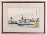
Painting by Ramon Froman depicting fishing boat on Galveston Bay.


A.2 Summary of you landscape system analysis and your development Targets
As compared to the 'Sustainable Development Goals: 17 Goals to Transform our World', goal risks related to Galveston Bay include:
- (3) GOOD HEALTH AND WELL-BEING: Air and water pollutants can make health decrease over time in the bay area.
- (6) CLEAN WATER AND SANITATION: Following oil spills and industrial-related pollution, the water has become very polluted in the bay, receiving a "C" grade in water quality for toxins found in bay sediments & contaminated dump sites (HARC, 2016).
- (7) AFFORDABLE AND CLEAN ENERGY: There is no shortage of energy in the bay due to the many oil rigs, but there is a dependency on fossil fuels for energy. More initiatives for wind, hydro and solar power could be made.
- (11) SUSTAINABLE CITIES AND COMMUNITIES: Although the location is prime for fishing, sun, liesure, and business, there is a constant worry that a storm could level everything, just as it did during the 1900 Hurricane and Hurricane Ike in 2008. Better ways to develop the area without fear of property loss should be pursued, as well as ways to develop without decimating ecosystems - the very ones that help slow erosion and storm surges.
- (12) RESPONSIBLE CONSUMPTION AND PRODUCTION: Development is very irresponsible along the bay. Fragile ecosystems are destroyed to development in the housing sector and industrial sector. Factories that use the water for cooling tend to over pump and pollute. Fishing is well-regulated due to laws.
- (14) LIFE BELOW WATER: As climate changes and more factories expel warm water into the ocean, bacteria and algae thrive, the water gets warmer and oxygen decreases. Fish and other marine flora and fauna cannot live there, and dead zones are created.
My hypothesis for this landscape is that if the pollution caused from the industrial areas and the land degradation and habitat loss from housing and industrial development is not curbed and better controlled, nearly all remaining natural areas and ecosystems will be destroyed or fragmented to such a level that they can not survive. Furthermore, as climate changes and storms continue to increase in frequency and intensity, the unvegetated, unprotected, heavily-developed coasts and barrier islands will be destroyed from harsh winds, waves and rising water levels.
There are some existing intitiatives for the Galveston Bay landscape. The Galveston Bay Foundation is a land conservation organization working to protect the estuary of Galveston Bay since 1987. "GBF has conserved over 8,000 acres of coastal habitat through property acquisitions and conservation easements and is working to substantially increase acreage conserved in the coming years" (Galveston Bay Foundation, 2018). GBF assists in shoreline management by developing “living shorelines”, which provide erosion control benefits while utilizing nature to enhance the existing natural shoreline habitat. Land trusts and initiatives have been organized to get community members and business owners involved. Children are educated during field trips and outdoor classroom exercises. Organized Oyster Reef and Wetland restoration projects are deployed, and groups do regular marine debris cleanup to improve habitat health. for There has been a recent push for tighter regulatory laws placed on factories and other industrial areas to hinder pollutants such as oil and trash entering the water. However, with the current rate of development and proposed growth for the future of the area, the high chance of oil spills, the amount of roads, parking lots and general loss of habitat to houses shows a bleak view for nature protection.

Graphic specifies who drives the landscape and its changes, what are the pressures on the landscape from these drivers, what is the resulting state of the environment from the pressures, what impacts occur following the changing state of the environment, and what responses are made in order to improve the problems arising.


This image depicts what the Galveston Bay could become if the oil spills, pollution and land degradation continues at the rate it currently is. Deoxygenation of the water will result in dead zones, and the industrial sector will continue to feed the issue. Storms and rising waters will take away any remaining natural areas.

A.3 Theory reflection
National Ocean Policy of the United States of America
'The National Ocean Policy sets forth a vision of an America whose stewardship ensures that the ocean, our coasts, and the Great Lakes are healthy and resilient, safe and productive, and understood and treasured so as to promote the well-being, prosperity, and security of present and future generations' (Bureau of Ocean Energy Management).
The National Ocean Policy (2010) specifies the following priority goals:
- Ecosystem-Based Management: protect, maintain, and restore the health of the ocean, coastal, and Great Lakes ecosystems and resources
- Coastal and Marine Spatial Planning (CMSP)
- Make informed decisions and improve understanding for all involved
- Coordinate with national security and foreign policies and their adjoined interests
- Improve understanding, resiliency, and adaptation to climate change and ocean acidification
- Provide regional ecosystem protection and restoration
- Improve water quality and sustainable practices on land
- Explore changing conditions in the arctic
- Develop ocean, coastal, and Great Lakes observations, mapping, and infrastructure
- Improve sustainability of ocean and coastal economies
- Preserve heritage
Several Federal agencies, including the Department of the Interior, work with a wide variety of tribal, state, and regional governments; private sector; scientists; the public; and national, regional, and local stakeholders to ensure public input and improved coordination. To ensure the policy is correctly implemented in all effected places, the interagency National Ocean Council was assembled, and later the National Ocean Policy Implementation Plan in 2013. The National Ocean Policy Implementation Plan helps the public and private stakeholders better interpret the policy and which actions are needed to be executed to achieve the policy’s vision.
A.4 References
- https://obamawhitehouse.archives.gov/the-press-office/executive-order-stewardship-ocean-our-coasts-and-great-lakes
- https://obamawhitehouse.archives.gov/administration/eop/oceans/policy
- https://www.boem.gov/National-Ocean-Policy/
- https://www.doi.gov/pmb/ocean/national-ocean-policy
- https://tcwp.tamu.edu/files/2018/03/Ecologic_CITE15
- http://www.galvbaydata.org/www.galvbaydata.org/Habitat/Wetlands/EstuarineWetlands/tabid/849/Default
- http://arcgis02.h-gac.com/RLUIS/
Phase B: Landscape Evaluation and Assessment
B.1 Assessment Strategy
- Based on the hypothesis derived from your previous landscape systems analysis you are now asked to define the goals for assessing the landscape. Your assessment is the basis for evaluating the landscape status.
- Which elements and phenomena need to be mapped, why and how?
- This a text contribution, max 250 words
B.2 Mapping
- As defined by your assessment strategy you conduct the mapping and present your findings here
- As a minimum, at least three different themes need to be mapped, you may choose more if needed

Existing land use: Galveston Bay, surrounding shore, Galveston Island (western barrier island) and Goat Island (eastern barrier island)

Projected land use: following rising sea levels and extensive urbanization and industrialization of coastline and surrounding land.

Ecosystem services, Galveston Bay: Provisioning: Grains, Cotton, Silage, Hay, Fish, Beef. Supporting: Nutrient cycles, Stormwater and erosion control. Cultural: Recreation and Education
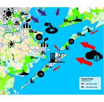
Threats posed to Galveston Bay.


B.3 Problem definition and priority setting
- Give a summary of the major findings of your mapping process, what are the problems/potentials identified?
- Draw a problems/potentials map
- Set priorities for the most relevant issues
- Your case problems potentials map.jpg
add caption here
B.4 Theory reflection
- Please reflect the assessment and evaluation methods used based on at least three readings
- Did you encounter limitations'
- 200 words test contribution
B.5 References
- http://arcgis02.h-gac.com/RLUIS/
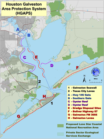
- https://cpb-us-e1.wpmucdn.com/news-network.rice.edu/dist/c/2/files/2014/03/0311-SSPEED-hgaps-med.jpg
- https://www.asla.org/2012awards/264.html
Phase C – Strategy and Master Plan
C.1 Goal Setting
- Define strategic planning objectives based on the evaluation findings
- Link back to your original targets from section one and the Development Goals
- 150 words text contribution
C.2 Spatial Strategy and Transect
- translate your strategic goals into a vision
- develop a spatial translation of your vision
- exemplify your vision in the form of a transect with concrete interventions
- add map(s) and visualizations
- Your case spatial translaton vision.jpg
add caption here
- Your case transect.jpg
add caption here
- Your case transect detail1.jpg
add caption here
- Your case transect detail2.jpg
add caption here
C.3 From Theory of Change to Implementation
- For implementing your vision: Which partnerships are needed? Which governance model is required?
- Who needs to act and how? Draw and explain a change/process model/timeline
- Which resources are needed? On which assets can you build?
- add 150 words text and visuals
- Your case spatial your governance model.jpg
add caption here
- Your case spatial your process model.jpg
add caption here
C.4 References
- give a full list of the references you have used for this section
D. Process Reflection
- Reflect in your intercultural and interdisciplinary team on the outcomes of your study
- Which limitations were you facing?
- What have you learnt from each other?
- What would you do differently next time?
- You can also use diagrams/visuals
- 250 words text