Sarcele-Corbu: Difference between revisions
| (109 intermediate revisions by 4 users not shown) | |||
| Line 9: | Line 9: | ||
{| align="right" width="400pt" style="background:Gainsboro; color:black" | {| align="right" width="400pt" style="background:Gainsboro; color:black" | ||
|- | |- | ||
| '''Area''' ||style="background:Lavender"| ''Workgroup 1: | | '''Area''' ||style="background:Lavender"| ''Workgroup 1: Săcele-Corbu'' | ||
|- | |- | ||
| '''Place''' || style="background:Lavender"|'' | | '''Place''' || style="background:Lavender"|''Săcele-Corbu'' | ||
|- | |- | ||
| '''Country''' || style="background:Lavender"|''Romania'' | | '''Country''' || style="background:Lavender"|''Romania'' | ||
|- | |- | ||
| '''Topics''' || style="background:Lavender"|'' | | '''Topics''' || style="background:Lavender"|''Coastal Line study of Săcele to Corbu'' | ||
|- | |- | ||
| '''Author(s)''' || style="background:Lavender"|''Anton Iulia-Alina, Gonțilă Larisa Cristina, Iuca Maria Monica, Ivănescu Maria-Alexandra, Giurgiu Andreea'' | | '''Author(s)''' || style="background:Lavender"|''Anton Iulia-Alina, Gonțilă Larisa Cristina, Iuca Maria Monica, Ivănescu Maria-Alexandra, Giurgiu Andreea'' | ||
| Line 27: | Line 27: | ||
= Rationale = | = Rationale = | ||
Săcele-Corbu area is very important as a mixt scientific reserve that is part of Danube Delta Biosphere Reserve (DDBR). The area is characterized by the species of birds that give a special fauna to this area, of which a large number are protected species. The site is a major wintering and passage site for numerous bird species, such as Red-necked Goose (Branta ruficollis). The plants in the area have a very important role in soil stabilization and erosion erosion. | |||
It is also an area that is already dedicated to practicing the helium-sea tourism and is characterized by wild beaches. | It is also an area that is already dedicated to practicing the helium-sea tourism and is characterized by wild beaches. | ||
The two areas have no tourist destination but are part of the Danube Delta Biosphere Reserve, being a public domain of national interest. | The two areas have no tourist destination but are part of the Danube Delta Biosphere Reserve, being a public domain of national interest. | ||
| Line 40: | Line 40: | ||
== A.1 Landscape layers and their system context == | == A.1 Landscape layers and their system context == | ||
=== Geomorphology, landscape units and coastal typology === | |||
According to the geomorphologic division of the coastal area, our area of interest is part of the Nordic Unit where for the boundary of the coastal zone, the width shall be set at the maximum limit of 150 m from the longest line of the sea (Governamental Decision 749/2004). | According to the geomorphologic division of the coastal area, our area of interest is part of the Nordic Unit where for the boundary of the coastal zone, the width shall be set at the maximum limit of 150 m from the longest line of the sea (Governamental Decision 749/2004). | ||
| Line 59: | Line 57: | ||
Type of shore, sedimentary characteristics: The southern jetties traps sediments transported here by shore-side current. For this reason, this sector acts as a sediment reservoir. | Type of shore, sedimentary characteristics: The southern jetties traps sediments transported here by shore-side current. For this reason, this sector acts as a sediment reservoir. | ||
Coastal dynamics: Stable / weak acreage | Coastal dynamics: Stable / weak acreage | ||
<gallery caption=" " widths="200px" heights="150px" perrow="5"> | |||
Plaja Vadu.jpg| | |||
b.jpg| | |||
d.jpg| | |||
c.jpg| | |||
</gallery> | </gallery> | ||
=== Land use === | === Land use === | ||
| Line 71: | Line 71: | ||
'''Corbu''' - Corbu villages dates back to the first Iron Age - 13th century- middle of the 4th century BC, close to the water spring. The practices were then agriculture, animal husbandry, fishing, crafts, commerce, but also the exchange of goods between the local population and the Greek settlers. | '''Corbu''' - Corbu villages dates back to the first Iron Age - 13th century- middle of the 4th century BC, close to the water spring. The practices were then agriculture, animal husbandry, fishing, crafts, commerce, but also the exchange of goods between the local population and the Greek settlers. | ||
''' | '''Săcele''' - Situated about 12 km south of Histria fortress, the area of Sacele commune, was part of the territory of the fortress. Histria Fortress was founded at the end of the 7th century BC as a port on the shore of the current Sinoe lagoon - the former open sea.'' | ||
*''The current situation | *''The current situation | ||
| Line 82: | Line 82: | ||
<gallery caption=" " widths="200px" heights="150px" perrow="5"> | <gallery caption=" " widths="200px" heights="150px" perrow="5"> | ||
land use.jpg| | |||
2.jpg| | |||
</gallery> | </gallery> | ||
=== Green/blue infrastructure === | === Green/blue infrastructure === | ||
In the studied territory there are areas that have potential for developing a green-blue infrastructure such as healthy ecosystems and naturally valuable areas outside protected areas such as floodplains, wetlands, coastal areas, natural forests (Vadu Forest) | In the studied territory there are areas that have potential for developing a green-blue infrastructure such as healthy ecosystems and naturally valuable areas outside protected areas such as <b>floodplains, wetlands, coastal areas,</b> <b>natural forests (Vadu Forest)</b> which can act as <b>ecological corridors or animal shelters</b>. Present in site are <b>Chituc Grind and the Ornithological Retreat Corbu - Nuntasi – Histria</b> areas, part of the <b>Danube Delta Biosphere Reserve</b> ( recognized as a wetland of international importance since 1990), where bird species of special importance to this area are encountered, a very large number of birds are protected species and is also the only place where the <b>Jackal</b> can be found. The site is a major wintering and passage site for numerous bird species, such as <b>Branta ruficolli</b>. | ||
In the area, measures are being taken regarding the ecological reconstruction of degraded surfaces, the reduction of industrial activities (Raw Metals Factory from Vadu for Siliciu). | In the area, measures are being taken regarding the ecological reconstruction of degraded surfaces, the reduction of industrial activities (Raw Metals Factory from Vadu for Siliciu). | ||
The wind farms are presented in this area | The <b>wind farms</b> are presented in this area, and for stimulate the developement of new farms, Agency for Payments and Intervention for Agriculture has provided support to farmers by offering subsidies for: | ||
Agency for Payments and Intervention for Agriculture has provided support to farmers by offering | - <b>Arable land </b>important for red-breasted goose feeding areas, | ||
- Arable land important for red-breasted goose feeding areas, | - Important <b>meadows</b> for birds, | ||
- Important meadows for birds, | - Maintaining <b>organic farming</b> practices, | ||
- Maintaining organic farming practices, | |||
- Etc. | - Etc. | ||
Mayors have agreed that measures need to be taken, such as: | Mayors have agreed that measures need to be taken, such as: | ||
• Mounting of RBDD boundary alert and signaling panels, as well as panels with information on access conditions in RBDD and beach activities; | • Mounting of RBDD boundary alert and signaling panels, as well as panels with information on access conditions in RBDD and beach activities; | ||
| Line 106: | Line 103: | ||
• Continuous monitoring by ARBDD commissioners of beach areas including entry / exit paths. | • Continuous monitoring by ARBDD commissioners of beach areas including entry / exit paths. | ||
The area is part of the project "Dobrogea Nord - Wild Earth between the waters" which aims at sustainable development of fisheries areas. | The area is part of the project <b>"Dobrogea Nord - Wild Earth between the waters"</b> which aims at <b>sustainable development</b> of fisheries areas. | ||
<gallery caption=" " widths="200px" heights="150px" perrow="5"> | <gallery caption=" " widths="200px" heights="150px" perrow="5"> | ||
map2.jpg| Green-Blue Infrastructure | |||
iarba.jpg| Corbu Beach | |||
sacalu.jpg| Jackal | |||
drum.jpg| Grindul Chituc | |||
pasari.jpg|Grindul Chituc | |||
padu.jpg| Vadu Forest | |||
</gallery> | </gallery> | ||
=== Actors and stakeholders === | === Actors and stakeholders === | ||
The actors and stakeholders from this area are represented by: | The actors and stakeholders from this area are represented by: | ||
1. Local, regional authorities - administer the area with administrative measures; | 1. Local, regional authorities - administer the area with administrative measures; | ||
| Line 146: | Line 147: | ||
10. Animal breeders, fishermen and farmers. | 10. Animal breeders, fishermen and farmers. | ||
=== Sacred spaces and heritage === | === Sacred spaces and heritage === | ||
Chituc - This sub-sector supports an important marine ecosystem, which is reflected in the designation of protected areas within the Danube Delta Biosphere Reserve (SCI, SAP and Ramsar sites) both through its delta area and its marine components . The Danube Delta sustains a significant number of protected habitats and species. The Black Sea SAP is also in this sub-sector. There are two protected cultural locations (Categories A and B) located in the immediate vicinity of Sinoe Lake; they are located near the sub-sector's border. There is a designated designated area for the development of crustaceans, intended for the growth and exploitation of marine molluscs (between Perisor and Chituc).1 | Chituc - This sub-sector supports an important marine ecosystem, which is reflected in the designation of protected areas within the Danube Delta Biosphere Reserve (SCI, SAP and Ramsar sites) both through its delta area and its marine components . The Danube Delta sustains a significant number of protected habitats and species. The Black Sea SAP is also in this sub-sector. There are two protected cultural locations (Categories A and B) located in the immediate vicinity of Sinoe Lake; they are located near the sub-sector's border. There is a designated designated area for the development of crustaceans, intended for the growth and exploitation of marine molluscs (between Perisor and Chituc).1 | ||
CORBU - This sub-sector supports an important marine ecosystem, which is reflected in the designation of protected areas within the Danube Delta Biosphere Reserve (SCI, SAP and Ramsar sites) both through its delta area and its marine components . The Danube Delta sustains a significant number of protected habitats and species. Black Sea SAP and Taslu Lakes up to Corbu SAP are also in this sub-sector. Cultural heritage includes: CT-I-s-B-02632, Archaeological site; CT-I-m-B-02632.01, Romanian Settlement from 1st to 4th Century, Ap. Hr .; CT-I-m-B-02632.02, Latenei Placement, Greek-Getic Culture, V, BC; CT-I-m-B-02632.03, Settlement, Hallstatt Late Age, VI-V a.Chr.1 | CORBU - This sub-sector supports an important marine ecosystem, which is reflected in the designation of protected areas within the Danube Delta Biosphere Reserve (SCI, SAP and Ramsar sites) both through its delta area and its marine components . The Danube Delta sustains a significant number of protected habitats and species. Black Sea SAP and Taslu Lakes up to Corbu SAP are also in this sub-sector. Cultural heritage includes: CT-I-s-B-02632, Archaeological site; CT-I-m-B-02632.01, Romanian Settlement from 1st to 4th Century, Ap. Hr .; CT-I-m-B-02632.02, Latenei Placement, Greek-Getic Culture, V, BC; CT-I-m-B-02632.03, Settlement, Hallstatt Late Age, VI-V a.Chr.1 | ||
=== Visual appearance and landscape narrative === | |||
“The Anchor of Danube Delta” | |||
Landscape character is a mixture between the wild flora, fauna, and sights of the landscape. | |||
The character of the area is seen from two different point of views: the realistic one, and the subjective one, in which the filter of understanding and perception of each person interferes (the landscape is seen, smelled, heard, felt). Thus, this area, including the Danube Delta, represent an inspiration for many artists all over the country in the last century, but for foreign ones as well. | |||
Mihai Sadoveanu (1880-1961), Romanian writer from Iași, describes the Danube Delta, including Săcele-Corbu area in the volume called “The country after darkness” (“Țara de dincolo de negură” 1926), in the narrative called “The Mirage” (“Mirajul”). He describes the area as wild, “like entering another life, or a fairtytale”. He discovers the area slowly, step by step, from the smallest detail, to the greatest element. Essential elements described are related to fauna and flora (he reminds of different bird and growth species). | |||
Alexandru Vlahuță (1858-1919), Romanian writer from Vaslui, describes the area in the volume called “Pituresque Romania”(“România pitorească” 1901). He also describes the area as a wild, virgin area, less touched by mankind: “this deep silence, fully controlling everywhere, makes you think you are away from Earth, in a lonely planet”. He concentrates his narrative on the Danube itself, the river is ruling the place, how the little boats and birds are seen from great distance, wild horses are surprised by human presence, the vegetation is untamed. | |||
Besides the narrative description of the Săcele-Corbu and Danube Delta area, visual representation as paintings are common. Contemporary artist such as Adrian Timar, Voineagu and others find their muse in this area. Their paintings are capturing the wildness, the flora, the fauna, the cliche lonely fisherman with small boats passing. | |||
<gallery caption=" " widths="200px" heights="150px" perrow="5"> | <gallery caption=" " widths="200px" heights="150px" perrow="5"> | ||
picture1.jpg| | |||
picture2.jpg| | |||
</gallery> | </gallery> | ||
== A.2 Summary of you landscape system analysis and your development Targets == | == A.2 Summary of you landscape system analysis and your development Targets == | ||
<gallery caption=" " widths=" | * ''Hypothesis | ||
File: | |||
The Săcele-Corbu-Chituc area is important due to the fauna and flora resort, the possibilities of research on rare phenomena, and the virgin beaches. This area supports rare endangered species and contains valuable preserved landscapes. | |||
If no protection measures are taken against major interventions, the area will be exposed to massive degradation, it will lose its protected species, and the soil will destabilize due to flooding that may occur'' | |||
<gallery caption=" " widths="200px" heights="150px" perrow="5"> | |||
File:Example.jpg| | |||
risk.jpg| | |||
var 2.jpg| | |||
File:Example1.jpg| | |||
</gallery> | </gallery> | ||
== A.3 Theory reflection == | == A.3 Theory reflection == | ||
* | |||
* | * The national strategy on climate change (Romania) | ||
The National Strategy on Climate change proposes key measures to be implemented in each sector, in order to reduce the greenhouse gas emissions. The areas concerned are: energetic efficiency, environmentally friendly transportation, modern agricultural technologies, risk management tools and the continuation of the project “the green house” among others by changing the behavior of household consumers with education campaigns on climate change. | |||
* EU Nature Protection Policy - European Commission Natura 2000 | |||
Since 1992, the European Union has promoted as the main nature conservation tool the development of the Natura 2000 network of protected areas, targeting both EU and candidate countries. Natura 2000 is an ecological network of Natura 2000 sites of two types: Special Areas of Conservation (SAC) established under the Habitats Directive and Special Protection Areas (SPAs) established under the Birds Directive. | |||
The Sacele-Corbu area is part of the Natura 2000 European network and the special protection area (special areas of conservation ROSCI 0065 and special avifaunistic protection areas - ROSPA0076) is declared. | |||
References: https://natura2000.ro/ce-este-reteaua-natura-2000/ | |||
* SDG interantional | |||
The international sustainable development policy uses a global think of the changes they want to make, so that no one is left out. The main objectives for the next 15 years are to fight inequalities, fight poverty and combat climate change. There are 17 operational objectives, 3 of which aim and influence the landscape in all its forms all over the world. | |||
1. Climate action-Take urgent action to combat climate change and its impacts | |||
2. Life below water- The world's oceans - their temperature, chemistry, currents and life - drive global systems that make the Earth habitable for humanity | |||
3. Life on land -Sustainably manage forests, combat desertification, halt and reverse land degradation, halt biodiversity loss | |||
References: https://www.un.org/sustainabledevelopment/biodiversity/ | |||
== A.4 References == | == A.4 References == | ||
[1] [Coastal Masterplan, 2012] | |||
[2] http://agrointel.ro/63015/lista-completa-a-subventiilor | |||
[3]http://ec.europa.eu/environment/pubs/pdf/factsheets/green_infra/ro.pdf | |||
[4]http://www.histria-cheiledobrogei.ro/Turism-3/Rezervatia-Biosferei-Delta-Dunarii-5,Grindul-Chituc-23 | |||
[5]http://www.histria-cheiledobrogei.ro/Turism-3/Rezervatia-Biosferei-Delta-Dunarii-5,Refugiul-ornitologic-Corbu-Nuntasi-Histria-25 | |||
[6] https://natura2000.ro/ce-este-reteaua-natura-2000/ | |||
[7]http://www.birds.kz/v2taxon.php?s=35&l=en | |||
[8] https://www.click.ro/news/national/cele-mai-frumoase-plaje-din-romania-afla-ce-locuri-nu-trebuie-sa-ratezi-aceasta-vara | |||
[9] https://www.researchgate.net/publication/296680219_HABIT-CHANGE_5_3_1g_DDNI_CAMP_for_Danube_Delta_BR/figures?lo=1&utm_source=google&utm_medium=organic | |||
[10] http://www.constanta-aproape.ro/uploads/materiale/harti.pdf | |||
[11] https://en.wikipedia.org/wiki/The_Carlyle_Group | |||
[12] https://www.investingromania.com/en/companies/s-n-t-g-n-transgaz-s-a | |||
[13] http://rbsta.ro/en/portfolio_page/black-sea-oil-gas-s-r-l/ | |||
[14] http://www.coastalwiki.org/wiki/Theme_1_-_Social_and_economic_aspects_of_ICZM | |||
[15] http://primariacorbu.ro/?page_id=41 | |||
[16] https://www.primariasacelect.ro/ | |||
[17] https://www.transgaz.ro/sites/default/files/anunt_decizie_de_emitere_proiect_vadu-tranzit_1.pdf | |||
[18] https://romanialibera.ro/economie/finante-banci/declara%C5%A2ii-de-avere-2013--stolojan--actiuni-transgaz-in-valoare-de-peste-1-milion-de-lei-307672 | |||
[19] http://www.mmediu.ro/categorie/strategia-cresc/117 | |||
= Phase B: Landscape Evaluation and Assessment = | = Phase B: Landscape Evaluation and Assessment = | ||
== B.1 Assessment Strategy == | == B.1 Assessment Strategy == | ||
The main goals for the assessment of the landscape, which were determined for this case study, are: | |||
a. to provide information about the problems and the possible risks for the site | |||
b. to identify sensitive aspects of the site | |||
c. to develop plans and strategies in order to protect the site and to value the potential aspects of the site | |||
As mentioned in the previous part (see A.2 Summary of your landscape system analysis and your development targets), the main problems and possible risks for the site is due to the massive degradation of the area, vulnerability of the endangered species (both flora and fauna), floodings that can alterate the ecosystem, and the more interest and the pressure that comes from the real estate market (the virgin beaches attract more and more aggressive urban developments will definitely change the structure of the landscape). | |||
Goals listed above are based on the present state of the site. First of all, we need to collect the available data regarding the specific costal landscape characteristics, then to identify the potential and the vulnerable aspects of the site. | |||
As part of the assessment, the elements identified, that need to be represented, are the current land use, the land use after the floodings change, the land after the change in the flora and fauna, mapping the possible risks, problems and potential of the site, including the parts of the site that are vulnerable to the real estate market regarding brutal urban development. | |||
Gathering all the information listed above, we can define the problems, risks, potential elements to outline the future goal settings and strategy for the Corbu-Săcele costal landscape. | |||
== B.2 Mapping == | == B.2 Mapping == | ||
<gallery caption=" " widths="500px" heights="200px" perrow="1"> | <gallery caption=" " widths="500px" heights="200px" perrow="1"> | ||
Example22.jpg| | |||
zone afectate M.jpg| | |||
zone A.jpg| | |||
</gallery> | </gallery> | ||
== B.3 Problem definition and priority setting == | == B.3 Problem definition and priority setting == | ||
Our targets are ensuring the life sustaining and regulating functions of the sea , a healthy and productive marine environment by using sustainable development and transparent strategies to build resilient coastal communities by sharing the benefits and the responsibilities. | |||
Given that the conservation of natural areas is proving to be a next to impossible task without proper finance, eco- tourism seems like the best option that could bring in the money and raise the economy while still working towards preserving biodiversity and pristine landscapes. | |||
We believe that in this area Eco-tourism is the best way to achieve our goals given the wildlife richness and the landscape and the fact that it is already a popular spot with tourists. | |||
<gallery caption=" " widths="500px" heights="200px" perrow="5"> | <gallery caption=" " widths="500px" heights="200px" perrow="5"> | ||
+si-.jpg|''add caption here'' | |||
</gallery> | </gallery> | ||
| Line 232: | Line 283: | ||
== B.5 References == | == B.5 References == | ||
[1] http://www.constanta-aproape.ro/uploads/materiale/harti.pdf | |||
[2] https://en.wikipedia.org/wiki/The_Carlyle_Group | |||
[3] https://www.investingromania.com/en/companies/s-n-t-g-n-transgaz-s-a | |||
[4] http://rbsta.ro/en/portfolio_page/black-sea-oil-gas-s-r-l/ | |||
[5] http://www.coastalwiki.org/wiki/Theme_1_-_Social_and_economic_aspects_of_ICZM | |||
[6] http://primariacorbu.ro/?page_id=41 | |||
[7] https://www.primariasacelect.ro/ | |||
[8] https://www.transgaz.ro/sites/default/files/anunt_decizie_de_emitere_proiect_vadu-tranzit_1.pdf | |||
[9] https://romanialibera.ro/economie/finante-banci/declara%C5%A2ii-de-avere-2013--stolojan--actiuni-transgaz-in-valoare-de-peste-1-milion-de-lei-307672 | |||
[10] http://www.mmediu.ro/categorie/strategia-cresc/117 | |||
=Phase C – Strategy and Master Plan = | =Phase C – Strategy and Master Plan = | ||
== C.1 Goal Setting == | == C.1 Goal Setting == | ||
Our goals and objectives are to reduce future urban development in the area thus preventing massive degradation, reducing flora and fauna vulnerability and protecting the local biodiversity for future developments, altering the landscape as little as possible while still making use of it through eco-tourism is the ideal compromise between economic development and sustainability for the generations to come. | |||
Current and future exploitation of natural gasses or any other fossil fuels should be banned. Instead, investments in green energies such as wind, solar or wave power should have priority, since the local geographical conditions are suitable for these. | |||
Because the Corbu-Sacele area is close to where the Danube flows into the sea there is a higher concentration of plastic waste here so concentrated efforts to dispose of these should be practiced such as banning plastic completely as well as properly dispose of the plastics currently found in the sea and on land. | |||
== C.2 Spatial Strategy and Transect == | == C.2 Spatial Strategy and Transect == | ||
* | *The strategy of our project aims to highlight the important natural elements of the area and to provide visitors with a different experience than ordinary sea tourism, a tourism based on education, relaxation, in a quiet environment, in a natural way , with minimal interventions that do not affect the existing microclimate. | ||
* | |||
* | *So we proposed two types of transects. The main route connects the village of Mihai Viteazul to the village of Vadu, and can be reached by car or bicycle, which is used to provide faster accessibility to places of interest such as camping or accommodation. The second transect, the dotted line, is the road near the coastal area, which can be reached by bicycle or pedestrian, and goes through a number of spaces that offer various activities. | ||
*Some of the proposed interventions are: in the village Mihai Viteazu a hotel area made of peasant houses sepcious near the sea areas, in the village of Sinoe arranging some places for camping, around the lakes making installations such as wooden platforms and an area with a wave telescope where you can watch the night sky, in Sacele and Corbu villages information points and also a guide for coordinating excursions in wetlands, in the beach area arranging it with minimal interventions (umbrellas) canvas tents, and not last but not least in wet areas the introduction of landmark elements from natural materials and the possibility of excursions coordinated with the boat. | |||
<gallery caption=" " widths="500px" heights="200px" perrow="1"> | <gallery caption=" " widths="500px" heights="200px" perrow="1"> | ||
coland3.jpg| | |||
1-4.jpg| | |||
5and6.jpg| | |||
b and a.jpg| | |||
section transect a.jpg| | |||
</gallery> | </gallery> | ||
[[File:Exampllee.jpg]] | |||
== C.3 From Theory of Change to Implementation == | == C.3 From Theory of Change to Implementation == | ||
Partnerships occur at the international, national and local levels, among institutions such as universities, non-governmental organizations (NGOs) and community-based organizations, as well as temporary or virtual organizations, such as international, national and local conferences or dialogues. | |||
Rapid changes in socio-economic conditions are reflected in the determination to carry on inclusive, cooperative dialogue on emerging issues. | |||
While nongovernmental organizations (NGOs) are perhaps the most visible, trends of decentralization, popular worldwide, have created a vast number of local governments whose officials and community participants are more aware of environmental, social and economic inter-relatedness. | |||
We also note that here, in this area are many opportunities for partnerships among various combinations of citizens, government, NGOs and the private sector. Many partnerships are not contained within one level, but involve partners across two or more levels. | |||
Government contributions can be complementary: for example, national funding, regional coordination and local support with implementation. | |||
At the grassroots level, NGOs are vital to the current slogans, such as “think globally and act locally”, thereby reflecting linkage between the macro and micro arenas for governance. | |||
With this this perspective in mind we partake in this discussion on partnerships in governance, and we hope that these discussions will result in new perceptions, new understanding, and many exciting and effective partnerships for governance result from these discussions. | |||
<gallery caption=" " widths="500px" heights="200px" perrow="1"> | <gallery caption=" " widths="500px" heights="200px" perrow="1"> | ||
sacele C3.jpg| | |||
</gallery> | </gallery> | ||
== C.4 References == | == C.4 References == | ||
* ''give a full list of the references you have used for this section'' | * ''give a full list of the references you have used for this section'' | ||
[1] http://www.langhamhospitality.com/html/eng/corporate/social.jsp | |||
[2] http://web.unep.org/annualreport/2016/ | |||
[3] http://www.itnewsbuzz.com/wp-content/uploads/2018/02/Startup-Ecosystem | |||
[4] http://web.unep.org/coastal-eba/implementation-strategy | |||
[5] http://www.fao.org/docrep/010/ag127e/AG127E10.html | |||
[6] http://www.planning.nsw.gov.au/~/media/Files/DPE/Guidelines/coastal-design-guidelines-for-nsw-2003-02.ashx | |||
== D. Process Reflection == | |||
From this project we learned that is important to establish a clear logical pathway for how the selected adaptation options and the associated activities will contribute to achieving the adaptation goals (e.g. reduction in vulnerability/reduction in impact using ecosystem services- coastal services) and broader objectives (e.g. more resilient society/other development and environmental objectives). | |||
Our goals must be more SMART: | |||
'''S'''pecific, | |||
'''M'''easurable, | |||
'''A'''chievable, | |||
'''R'''ealistic and | |||
'''T'''ime-bound | |||
and to agree a common vision that manages expectations amongst all stakeholders involved in implementing the adaptation option(s). | |||
Another thing that we learned is once adaptation options have been selected, the planners will need to develop a clear, practical roadmap for implementation. The implementation design should cover the activities which need to be carried out at a range of levels (including site-based, ecosystem, landscape, regional and national). This may also need to cover: building capacity for implementation; how to work with stakeholders and link with other relevant initiatives; and developing monitoring and evaluation for accountability, transparency and mid- to long-term adaptive management. | |||
Latest revision as of 14:07, 15 June 2018
>>>back to working groups overview
| Area | Workgroup 1: Săcele-Corbu | |
| Place | Săcele-Corbu | |
| Country | Romania | |
| Topics | Coastal Line study of Săcele to Corbu | |
| Author(s) | Anton Iulia-Alina, Gonțilă Larisa Cristina, Iuca Maria Monica, Ivănescu Maria-Alexandra, Giurgiu Andreea | |

| ||
Rationale
Săcele-Corbu area is very important as a mixt scientific reserve that is part of Danube Delta Biosphere Reserve (DDBR). The area is characterized by the species of birds that give a special fauna to this area, of which a large number are protected species. The site is a major wintering and passage site for numerous bird species, such as Red-necked Goose (Branta ruficollis). The plants in the area have a very important role in soil stabilization and erosion erosion. It is also an area that is already dedicated to practicing the helium-sea tourism and is characterized by wild beaches. The two areas have no tourist destination but are part of the Danube Delta Biosphere Reserve, being a public domain of national interest.
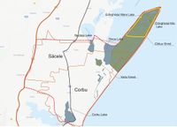
Location and scope
You can edit this map with the map editor
A Landscape System Analysis
A.1 Landscape layers and their system context
Geomorphology, landscape units and coastal typology
According to the geomorphologic division of the coastal area, our area of interest is part of the Nordic Unit where for the boundary of the coastal zone, the width shall be set at the maximum limit of 150 m from the longest line of the sea (Governamental Decision 749/2004).
On the territory of Săcele commune, the coastal area falls within the Chituc Grindel area, in the buffer zone of the RBDD and in the economic zone of the RBDD, as described in the functional areas of RBDD of GD 248/1994 - Annex 1. - On the territory of Corbu commune the coastal area falls within the economic zone of the RBDD;
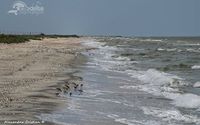
The sedimentary unit from this area is from the Zatoane to the Midia Port and is divided into two sub-sectors Chituc and Corbu (Cape Midia). Chituc Description: Length about 19 km. Beaches formed by a series of fossil barrier beaches, made up of sediments brought by the Danube, redistributed by waves and currents, and shells. Type of shore, sedimentary characteristics: Severe coastal sedimentary stream moving southwards. The sediments are brought by the Danube, with a quantity of shells. There are significant amounts of heavy minerals present in beach sediments due to relative enrichment (selective remobilization of light silicon minerals, while heavy minerals have remained or have been transported at smaller distances). The coastline is north - east - south - west from Portita to Midia, and is exposed to the strongest windstorms in the north. There is, therefore, a strong supply of seaside sediments in the south. This area faces mild erosion, but is generally stable along the southern unit, where a certain influence of the Midia dams can be felt. Coastal dynamics: Poor-stable erosion to the south (approximately 1.5 m / year)
CORBU - CAP MIDIA Description: Length about 13 km. Pocket beaches accumulated in front of the cliffs. There is no contribution from the cliff, which is mainly composed of the banks. Sediments are from the Danube and consist of shells. It is a natural area without protection. Type of shore, sedimentary characteristics: The southern jetties traps sediments transported here by shore-side current. For this reason, this sector acts as a sediment reservoir. Coastal dynamics: Stable / weak acreage


Land use
- History of area use
Corbu - Corbu villages dates back to the first Iron Age - 13th century- middle of the 4th century BC, close to the water spring. The practices were then agriculture, animal husbandry, fishing, crafts, commerce, but also the exchange of goods between the local population and the Greek settlers.
Săcele - Situated about 12 km south of Histria fortress, the area of Sacele commune, was part of the territory of the fortress. Histria Fortress was founded at the end of the 7th century BC as a port on the shore of the current Sinoe lagoon - the former open sea.
- The current situation
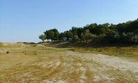
On the administrative territory of Corbu commune and Sacele commune there are a number of uses of the area. Housing, with a population of 5450 inhabitants in Corbu, 2100 inhabitants of Sacele. The transport infrastructure includes: county roads (DJ 266), communal railways and railways. Other activities are: mining holdings for limestone extraction and consecrated aggregates, sport fishing, hen farm, harbor, grain farming (90% of the population involved in Sacele), tourism, industry, services, recreation, public space and water and energy supply services. Another important area is Chituc Grindul afferent to the protected natural area (belonging to the Danube Delta Biosphere Reserve), where birds of different species are found (289 protected species have been identified in Grind), low-water lakes partially covered with floating vegetation; flooded depression areas with fixed hydrophilic vegetation, represented by reed and rush communities; meadows on low coasts and less-favored coastal meadows.
Other important areas for loisir are Corbu Lake, Corbu Beach and Vadu Beach (virgin beaches). Recently, a Local Urban Plan has been developed and includes proposals for a new tourism development and private housing on the shore.


Green/blue infrastructure
In the studied territory there are areas that have potential for developing a green-blue infrastructure such as healthy ecosystems and naturally valuable areas outside protected areas such as floodplains, wetlands, coastal areas, natural forests (Vadu Forest) which can act as ecological corridors or animal shelters. Present in site are Chituc Grind and the Ornithological Retreat Corbu - Nuntasi – Histria areas, part of the Danube Delta Biosphere Reserve ( recognized as a wetland of international importance since 1990), where bird species of special importance to this area are encountered, a very large number of birds are protected species and is also the only place where the Jackal can be found. The site is a major wintering and passage site for numerous bird species, such as Branta ruficolli.
In the area, measures are being taken regarding the ecological reconstruction of degraded surfaces, the reduction of industrial activities (Raw Metals Factory from Vadu for Siliciu). The wind farms are presented in this area, and for stimulate the developement of new farms, Agency for Payments and Intervention for Agriculture has provided support to farmers by offering subsidies for: - Arable land important for red-breasted goose feeding areas, - Important meadows for birds, - Maintaining organic farming practices, - Etc.
Mayors have agreed that measures need to be taken, such as: • Mounting of RBDD boundary alert and signaling panels, as well as panels with information on access conditions in RBDD and beach activities; • Establishment of common parking spaces and arrangement of parking areas for motor vehicles, location of barriers so that activities in the beach area are made terrestrial; • Daily hygiene of beaches by the mentioned municipalities; • Continuous monitoring by ARBDD commissioners of beach areas including entry / exit paths.
The area is part of the project "Dobrogea Nord - Wild Earth between the waters" which aims at sustainable development of fisheries areas.
-
 Green-Blue Infrastructure
 -
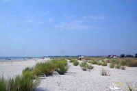 Corbu Beach
 -
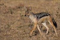 Jackal
 -
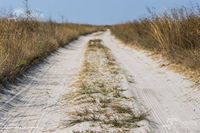 Grindul Chituc
 -
 Grindul Chituc
 -
 Vadu Forest


Actors and stakeholders
The actors and stakeholders from this area are represented by:
1. Local, regional authorities - administer the area with administrative measures;
2. “Romanian Waters” National - deal with the monitoring of the lakes in the area, the coastal zone afferent to the Black Sea and the defense against floods;
3. Non-governmental organizations, NGO:
     - Mare Nostrum, dolphin monitoring, placement of information panels, etc.;
     - WWF, is working in the framework of the regional Danube-Carpathian Programme;
     - Romanian Ornithological Society (SOR) carries out activities for the protection of birds and nature;
     - Various NGOs dealing with saving Chituc Grind.
4. Administration of the Danube Delta Biosphere Reserve (ARBDD) deals with the management of the natural heritage of the public domain of national interest of the Reserve, as well as for the restoration and protection of the physico-geographic units on the territory of RBDD;
5. Army force, there is a military unit in the area;
6. The economic agent
     - Restaurants;
     - Accommodation;
     - The Carslyle Group which now owns the Black Sea Oil&Gas company are planning to build the gas pipeline with the national state-owned Transgaz company (in which Eurodeputate Theodor Stolojan owns over 5000 shares valued at about 230.000 euros).  The gas transportation pipeline will start construction from the pickup point (from the Black Sea), which is 2000m from Vadu town through to the tranzit 1 pipeline which is in the area of the town Gradina. More than half of the lenght of this pipeline will pas through the communes Corbu and Sacele.
7. Research Institute and Universities;
8. Historical - there are archaeological sites in the area;
9. Tourists - practice tourism in nature;
10. Animal breeders, fishermen and farmers.
Sacred spaces and heritage
Chituc - This sub-sector supports an important marine ecosystem, which is reflected in the designation of protected areas within the Danube Delta Biosphere Reserve (SCI, SAP and Ramsar sites) both through its delta area and its marine components . The Danube Delta sustains a significant number of protected habitats and species. The Black Sea SAP is also in this sub-sector. There are two protected cultural locations (Categories A and B) located in the immediate vicinity of Sinoe Lake; they are located near the sub-sector's border. There is a designated designated area for the development of crustaceans, intended for the growth and exploitation of marine molluscs (between Perisor and Chituc).1 CORBU - This sub-sector supports an important marine ecosystem, which is reflected in the designation of protected areas within the Danube Delta Biosphere Reserve (SCI, SAP and Ramsar sites) both through its delta area and its marine components . The Danube Delta sustains a significant number of protected habitats and species. Black Sea SAP and Taslu Lakes up to Corbu SAP are also in this sub-sector. Cultural heritage includes: CT-I-s-B-02632, Archaeological site; CT-I-m-B-02632.01, Romanian Settlement from 1st to 4th Century, Ap. Hr .; CT-I-m-B-02632.02, Latenei Placement, Greek-Getic Culture, V, BC; CT-I-m-B-02632.03, Settlement, Hallstatt Late Age, VI-V a.Chr.1
Visual appearance and landscape narrative
“The Anchor of Danube Delta”
Landscape character is a mixture between the wild flora, fauna, and sights of the landscape. The character of the area is seen from two different point of views: the realistic one, and the subjective one, in which the filter of understanding and perception of each person interferes (the landscape is seen, smelled, heard, felt). Thus, this area, including the Danube Delta, represent an inspiration for many artists all over the country in the last century, but for foreign ones as well.
Mihai Sadoveanu (1880-1961), Romanian writer from Iași, describes the Danube Delta, including Săcele-Corbu area in the volume called “The country after darkness” (“Țara de dincolo de negură” 1926), in the narrative called “The Mirage” (“Mirajul”). He describes the area as wild, “like entering another life, or a fairtytale”. He discovers the area slowly, step by step, from the smallest detail, to the greatest element. Essential elements described are related to fauna and flora (he reminds of different bird and growth species). Alexandru Vlahuță (1858-1919), Romanian writer from Vaslui, describes the area in the volume called “Pituresque Romania”(“România pitorească” 1901). He also describes the area as a wild, virgin area, less touched by mankind: “this deep silence, fully controlling everywhere, makes you think you are away from Earth, in a lonely planet”. He concentrates his narrative on the Danube itself, the river is ruling the place, how the little boats and birds are seen from great distance, wild horses are surprised by human presence, the vegetation is untamed. Besides the narrative description of the Săcele-Corbu and Danube Delta area, visual representation as paintings are common. Contemporary artist such as Adrian Timar, Voineagu and others find their muse in this area. Their paintings are capturing the wildness, the flora, the fauna, the cliche lonely fisherman with small boats passing.


A.2 Summary of you landscape system analysis and your development Targets
- Hypothesis
The Săcele-Corbu-Chituc area is important due to the fauna and flora resort, the possibilities of research on rare phenomena, and the virgin beaches. This area supports rare endangered species and contains valuable preserved landscapes. If no protection measures are taken against major interventions, the area will be exposed to massive degradation, it will lose its protected species, and the soil will destabilize due to flooding that may occur


A.3 Theory reflection
- The national strategy on climate change (Romania)
The National Strategy on Climate change proposes key measures to be implemented in each sector, in order to reduce the greenhouse gas emissions. The areas concerned are: energetic efficiency, environmentally friendly transportation, modern agricultural technologies, risk management tools and the continuation of the project “the green house” among others by changing the behavior of household consumers with education campaigns on climate change.
- EU Nature Protection Policy - European Commission Natura 2000
Since 1992, the European Union has promoted as the main nature conservation tool the development of the Natura 2000 network of protected areas, targeting both EU and candidate countries. Natura 2000 is an ecological network of Natura 2000 sites of two types: Special Areas of Conservation (SAC) established under the Habitats Directive and Special Protection Areas (SPAs) established under the Birds Directive.
The Sacele-Corbu area is part of the Natura 2000 European network and the special protection area (special areas of conservation ROSCI 0065 and special avifaunistic protection areas - ROSPA0076) is declared.
References: https://natura2000.ro/ce-este-reteaua-natura-2000/
- SDG interantional
The international sustainable development policy uses a global think of the changes they want to make, so that no one is left out. The main objectives for the next 15 years are to fight inequalities, fight poverty and combat climate change. There are 17 operational objectives, 3 of which aim and influence the landscape in all its forms all over the world. 1. Climate action-Take urgent action to combat climate change and its impacts 2. Life below water- The world's oceans - their temperature, chemistry, currents and life - drive global systems that make the Earth habitable for humanity 3. Life on land -Sustainably manage forests, combat desertification, halt and reverse land degradation, halt biodiversity loss
References: https://www.un.org/sustainabledevelopment/biodiversity/
A.4 References
[1] [Coastal Masterplan, 2012]
[2] http://agrointel.ro/63015/lista-completa-a-subventiilor
[3]http://ec.europa.eu/environment/pubs/pdf/factsheets/green_infra/ro.pdf
[4]http://www.histria-cheiledobrogei.ro/Turism-3/Rezervatia-Biosferei-Delta-Dunarii-5,Grindul-Chituc-23
[6] https://natura2000.ro/ce-este-reteaua-natura-2000/
[7]http://www.birds.kz/v2taxon.php?s=35&l=en
[10] http://www.constanta-aproape.ro/uploads/materiale/harti.pdf
[11] https://en.wikipedia.org/wiki/The_Carlyle_Group
[12] https://www.investingromania.com/en/companies/s-n-t-g-n-transgaz-s-a
[13] http://rbsta.ro/en/portfolio_page/black-sea-oil-gas-s-r-l/
[14] http://www.coastalwiki.org/wiki/Theme_1_-_Social_and_economic_aspects_of_ICZM
[15] http://primariacorbu.ro/?page_id=41
[16] https://www.primariasacelect.ro/
[17] https://www.transgaz.ro/sites/default/files/anunt_decizie_de_emitere_proiect_vadu-tranzit_1.pdf
[19] http://www.mmediu.ro/categorie/strategia-cresc/117
Phase B: Landscape Evaluation and Assessment
B.1 Assessment Strategy
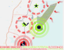
The main goals for the assessment of the landscape, which were determined for this case study, are: a. to provide information about the problems and the possible risks for the site b. to identify sensitive aspects of the site c. to develop plans and strategies in order to protect the site and to value the potential aspects of the site
As mentioned in the previous part (see A.2 Summary of your landscape system analysis and your development targets), the main problems and possible risks for the site is due to the massive degradation of the area, vulnerability of the endangered species (both flora and fauna), floodings that can alterate the ecosystem, and the more interest and the pressure that comes from the real estate market (the virgin beaches attract more and more aggressive urban developments will definitely change the structure of the landscape). Goals listed above are based on the present state of the site. First of all, we need to collect the available data regarding the specific costal landscape characteristics, then to identify the potential and the vulnerable aspects of the site. As part of the assessment, the elements identified, that need to be represented, are the current land use, the land use after the floodings change, the land after the change in the flora and fauna, mapping the possible risks, problems and potential of the site, including the parts of the site that are vulnerable to the real estate market regarding brutal urban development. Gathering all the information listed above, we can define the problems, risks, potential elements to outline the future goal settings and strategy for the Corbu-Săcele costal landscape.
B.2 Mapping


B.3 Problem definition and priority setting
Our targets are ensuring the life sustaining and regulating functions of the sea , a healthy and productive marine environment by using sustainable development and transparent strategies to build resilient coastal communities by sharing the benefits and the responsibilities.
Given that the conservation of natural areas is proving to be a next to impossible task without proper finance, eco- tourism seems like the best option that could bring in the money and raise the economy while still working towards preserving biodiversity and pristine landscapes.
We believe that in this area Eco-tourism is the best way to achieve our goals given the wildlife richness and the landscape and the fact that it is already a popular spot with tourists.
-
 add caption here

B.4 Theory reflection
- Please reflect the assessment and evaluation methods used based on at least three readings
- Did you encounter limitations'
- 200 words test contribution
B.5 References
[1] http://www.constanta-aproape.ro/uploads/materiale/harti.pdf
[2] https://en.wikipedia.org/wiki/The_Carlyle_Group
[3] https://www.investingromania.com/en/companies/s-n-t-g-n-transgaz-s-a
[4] http://rbsta.ro/en/portfolio_page/black-sea-oil-gas-s-r-l/
[5] http://www.coastalwiki.org/wiki/Theme_1_-_Social_and_economic_aspects_of_ICZM
[6] http://primariacorbu.ro/?page_id=41
[7] https://www.primariasacelect.ro/
[8] https://www.transgaz.ro/sites/default/files/anunt_decizie_de_emitere_proiect_vadu-tranzit_1.pdf
[10] http://www.mmediu.ro/categorie/strategia-cresc/117
Phase C – Strategy and Master Plan
C.1 Goal Setting
Our goals and objectives are to reduce future urban development in the area thus preventing massive degradation, reducing flora and fauna vulnerability and protecting the local biodiversity for future developments, altering the landscape as little as possible while still making use of it through eco-tourism is the ideal compromise between economic development and sustainability for the generations to come. Current and future exploitation of natural gasses or any other fossil fuels should be banned. Instead, investments in green energies such as wind, solar or wave power should have priority, since the local geographical conditions are suitable for these. Because the Corbu-Sacele area is close to where the Danube flows into the sea there is a higher concentration of plastic waste here so concentrated efforts to dispose of these should be practiced such as banning plastic completely as well as properly dispose of the plastics currently found in the sea and on land.
C.2 Spatial Strategy and Transect
- The strategy of our project aims to highlight the important natural elements of the area and to provide visitors with a different experience than ordinary sea tourism, a tourism based on education, relaxation, in a quiet environment, in a natural way , with minimal interventions that do not affect the existing microclimate.
- So we proposed two types of transects. The main route connects the village of Mihai Viteazul to the village of Vadu, and can be reached by car or bicycle, which is used to provide faster accessibility to places of interest such as camping or accommodation. The second transect, the dotted line, is the road near the coastal area, which can be reached by bicycle or pedestrian, and goes through a number of spaces that offer various activities.
- Some of the proposed interventions are: in the village Mihai Viteazu a hotel area made of peasant houses sepcious near the sea areas, in the village of Sinoe arranging some places for camping, around the lakes making installations such as wooden platforms and an area with a wave telescope where you can watch the night sky, in Sacele and Corbu villages information points and also a guide for coordinating excursions in wetlands, in the beach area arranging it with minimal interventions (umbrellas) canvas tents, and not last but not least in wet areas the introduction of landmark elements from natural materials and the possibility of excursions coordinated with the boat.


C.3 From Theory of Change to Implementation
Partnerships occur at the international, national and local levels, among institutions such as universities, non-governmental organizations (NGOs) and community-based organizations, as well as temporary or virtual organizations, such as international, national and local conferences or dialogues. Rapid changes in socio-economic conditions are reflected in the determination to carry on inclusive, cooperative dialogue on emerging issues. While nongovernmental organizations (NGOs) are perhaps the most visible, trends of decentralization, popular worldwide, have created a vast number of local governments whose officials and community participants are more aware of environmental, social and economic inter-relatedness.
We also note that here, in this area are many opportunities for partnerships among various combinations of citizens, government, NGOs and the private sector. Many partnerships are not contained within one level, but involve partners across two or more levels. Government contributions can be complementary: for example, national funding, regional coordination and local support with implementation. At the grassroots level, NGOs are vital to the current slogans, such as “think globally and act locally”, thereby reflecting linkage between the macro and micro arenas for governance. With this this perspective in mind we partake in this discussion on partnerships in governance, and we hope that these discussions will result in new perceptions, new understanding, and many exciting and effective partnerships for governance result from these discussions.

C.4 References
- give a full list of the references you have used for this section
[1] http://www.langhamhospitality.com/html/eng/corporate/social.jsp
[2] http://web.unep.org/annualreport/2016/
[3] http://www.itnewsbuzz.com/wp-content/uploads/2018/02/Startup-Ecosystem
[4] http://web.unep.org/coastal-eba/implementation-strategy
[5] http://www.fao.org/docrep/010/ag127e/AG127E10.html
D. Process Reflection
From this project we learned that is important to establish a clear logical pathway for how the selected adaptation options and the associated activities will contribute to achieving the adaptation goals (e.g. reduction in vulnerability/reduction in impact using ecosystem services- coastal services) and broader objectives (e.g. more resilient society/other development and environmental objectives). Our goals must be more SMART: Specific, Measurable, Achievable, Realistic and Time-bound and to agree a common vision that manages expectations amongst all stakeholders involved in implementing the adaptation option(s). Another thing that we learned is once adaptation options have been selected, the planners will need to develop a clear, practical roadmap for implementation. The implementation design should cover the activities which need to be carried out at a range of levels (including site-based, ecosystem, landscape, regional and national). This may also need to cover: building capacity for implementation; how to work with stakeholders and link with other relevant initiatives; and developing monitoring and evaluation for accountability, transparency and mid- to long-term adaptive management.