Loksa and Lahemaa: Difference between revisions
| (95 intermediate revisions by 4 users not shown) | |||
| Line 79: | Line 79: | ||
In the future, probably the area is going to be quite same because most of it is under nature protection where are many restrictions for building, agriculture etc. These restrictions are limiting the area development but they can advance tourism, which brings people to this area and raises the potential for economic growth. In Loksa maybe they are going to use more of this harbor because of its beneficial placement of port harbor and develop sea routes. Also, Loksa can be popular among tourists for its housing and food benefits. | In the future, probably the area is going to be quite same because most of it is under nature protection where are many restrictions for building, agriculture etc. These restrictions are limiting the area development but they can advance tourism, which brings people to this area and raises the potential for economic growth. In Loksa maybe they are going to use more of this harbor because of its beneficial placement of port harbor and develop sea routes. Also, Loksa can be popular among tourists for its housing and food benefits. | ||
<gallery caption=" " widths=" | <gallery caption=" " widths="400px" heights="300px" perrow="5"> | ||
File:Landuse map.jpg|''land use map'' | File:Landuse map.jpg|''land use map'' | ||
</gallery> | </gallery> | ||
| Line 89: | Line 89: | ||
* ''You find my background material on green infrastructure in our [[Reading_List_Coastal_Landscapes|reading list]]'' | * ''You find my background material on green infrastructure in our [[Reading_List_Coastal_Landscapes|reading list]]'' | ||
*''add 1-2 graphical representations to the image gallery, you can add more if you like'' | *''add 1-2 graphical representations to the image gallery, you can add more if you like'' | ||
Lahemaa National Park hold significant value for many spices with forests and bogs untouched by human activities. The national park was established to protect typical landscapes of Northern Estonia. Wooded areas in Lahemaa are predominantly unaffected by human activity. Vast territory with untouched forests, bogs, lakes and many rivers together with variable gulfs and peninsulas create stunning landscape to visit. | |||
Loksa and Lahemaa green infrastructure network comprise peninsulas, few islands, forests, meadows, grasslands, stony and sand beaches. At least 18 different hiking and study trails cover the coastal landscape of Lahemaa. Green infrastructure elements in Lahemaa are likely to change as natural process in nature. Human activities has an impact to Loksa and Lahemaa nature, but the goal is to keep parts of the park as they were in old times. | |||
Loksa and Lahemaa waterbodies cover all the national park. Uncountable number of streams are flowing through the park and connecting bigger rivers, lakes, mires, bogs and sea gulfs into blue infrastructure network. | |||
As a part of the green and blue infrastructure Lahemaa National Park is connected with other Estonia wildlife reserves. | |||
'''Major elements of a green infrastructure network in Lahemaa:''' | '''Major elements of a green infrastructure network in Lahemaa:''' | ||
| Line 137: | Line 148: | ||
'''Major elements of a blue infrastructure network in Lahemaa:''' | '''Major elements of a blue infrastructure network in Lahemaa:''' | ||
Sea | Sea gulfs: | ||
*''Hara | *''Hara gulf | ||
*''Eru | *''Eru gulf | ||
*''Kolga | *''Kolga gulf | ||
*''Käsmu | *''Käsmu gulf | ||
Rivers and streams: | Rivers and streams: | ||
| Line 163: | Line 174: | ||
*''Ulglaht | *''Ulglaht | ||
*''Lohja lake | *''Lohja lake | ||
*''Käsmu lake | |||
| Line 169: | Line 181: | ||
<gallery caption=" " widths="200px" heights="150px" perrow="5"> | <gallery caption=" " widths="200px" heights="150px" perrow="5"> | ||
File:Lahemaa matkarajad.JPG|''North-Estonian recreation area: Lahemaa National Park Hiking trails Map | File:Lahemaa matkarajad.JPG|''North-Estonian recreation area: Lahemaa National Park Hiking trails Map[[http://loodusegakoos.ee/where-to-go/national-parks/lahemaa-national-park]]'' | ||
File:Lahemaa | File:Lahemaa kaart.JPG|''Lahemaa National Park green and blue infrastructure[[http://www.keskkonnaamet.ee/public/lahemaa_skeem_151003_1024_737_1.jpg]] '' | ||
File: | File:Viru bog.JPG|''Viru bog from the tower[[http://loodus.keskkonnainfo.ee/eelis/]] | ||
File:Lahemaa.JPG|''Lahemaa National Park, by Henry Laupmaa'' | |||
File:Pruunkaru.JPG|''Braun bear in Lahemaa[[http://www.estonica.org/et/Loodus/Lahemaa_rahvuspark/Taimkate_ja_loomastik/]]'' | |||
File:Kivine rand.JPG|''Stony beach in Lahemaa'' | |||
File:Metsarada.JPG|''Hiking trail in Lahemaa pine forest'' | |||
File:Meri lahemaa.JPG|''View onto the sea '' | |||
</gallery> | </gallery> | ||
| Line 222: | Line 239: | ||
* ''Add text and visuals'' | * ''Add text and visuals'' | ||
Summary of DPSIR framework: | |||
* | |||
* | Driving forces: | ||
* | |||
* | *Tourism | ||
*Climate change | |||
*urbanization (Dense settlement) | |||
*popularity rise | |||
Impacts: | |||
Where coastal development uses and activities are not compatible or are not managed proactively and effectively, there can be loss of property, loss of public values, and damage to important infrastructure. This may restrict public access to varying degrees, impact on natural character and coastal landscapes, increasing the risks from natural hazards, affect coastal historic heritage, impact on coastal biodiversity and the special relationship of tangata whenua with the coastal environment. | |||
New and existing coastal developments can adversely can be a result of losing access to cultural resources (physical access and ability to harvest resources). Coastal development can result in increased competition for resources for customary use. | |||
Pressures: | Pressures: | ||
* | |||
* | *Human activities (recreational purposes like: hiking, water activities etc) | ||
* | *Pollution | ||
*climate change : New pest species are likely to occur as a result of climate change migratory species are vulnerable to loss of any of the habitats they require, and/or obstructions along their migratory route | |||
*Due to the presence of the sea and rivers in this area there is a lot of soil erosion | |||
State: | State: | ||
Lahemaa National Park was established on 1 June 1971 to preserve, protect, restore, study and raise awareness about the nature, landscapes, cultural heritage and balanced use of the environment of coastal areas in Northern Estonia. Lahemaa belongs to the Natura 2000 European network of protected habitat and bird site. There are approximately 3,600 permanent residents in the area, but in the summer the population of coastal villages increases many times over and it attract tourism from cities in Estonia and near countries. | |||
Due to historical sites and cultural programs such as dance festivals and so on, this place is attractive to tourists.under protection area | |||
Responses: | Responses: | ||
* | *the appropriateness of an activity | ||
* | *the functional need for activities to be in the coast | ||
*the reasonably foreseeable need of communities and future generations | |||
*ensuring activities are appropriately located | |||
*Tackling erosion | |||
*goverment of Estonia and Managing conflict will often involve determining what activity takes priority in certain areas | |||
<gallery caption=" " widths=" | <gallery caption=" " widths="1000px" heights="400px" perrow="5"> | ||
File: | File:Diagram.jpg|''explain your analysis briefly in the caption'' | ||
</gallery> | </gallery> | ||
<gallery caption=" " widths=" | considering the Sustainable Development Goals,the following goals may be at risk: | ||
File: | *11-sustainable cities and communities | ||
*13-climate action | |||
*14-life below water | |||
*15-life on land | |||
*16-partnerships for goals | |||
There are many activities that occur within the coastal environment including urban and rural development, transport, infrastructure, energy generation and transmission, food production and mineral extraction. Land on the coast is often limited. here is the potential to have incompatible activities adjacent to each other. Decisions made about coastal land development can also impact on the coastal marine area. Coastal development is a significant issue for the sustainable management of New Estonian’s coastal environment.Coastal development may result in conflicts between uses and activities. Not all uses of the coastal environment are compatible.also,Lahemaa Natural Heritage is working towards the sustainable management of dynamic landscapes and can advise on their management and conservation. | |||
Tourism is one of the largest and fastest growing industries in the world. It is an increasingly important source of income, employment and wealth in many countries. Its rapid expansion has, however, had detrimental environmental (and socio‐cultural) impacts in many regions.new approaches to sustainable tourism development in these countries should not only seek to minimize local environmental impact, but also give greater priority to community participation and poverty alleviation.more emphasis should be given to a ‘pro‐poor tourism’ approach at both national and international levels. | |||
<gallery caption=" " widths="1000px" heights="400px" perrow="5"> | |||
File:TARGET.jpg|''explain your hypthesis briefly in the caption'' | |||
</gallery> | </gallery> | ||
| Line 260: | Line 304: | ||
'''INTERNATIONAL POLICY DOCUMENT''' | |||
'''Sustainable development goals''' | |||
On 1 January 2016, the 17 Sustainable Development Goals of the 2030 Agenda for Sustainable Development. Over the next fifteen years, with these new Goals that universally apply to all, countries will mobilize efforts to end all forms of poverty, fight inequalities and tackle climate change, while ensuring that no one is left behind. | |||
The SDGs, also known as Global Goals, build on the success of the Millennium Development Goals and aim to go further to end all forms of poverty. The new Goals are unique in that they call for action by all countries, poor, rich and middle-income to promote prosperity while protecting the planet. They recognize that ending poverty must go hand-in-hand with strategies that build economic growth and addresses a range of social needs including education, health, social protection, and job opportunities, while tackling climate change and environmental protection. | |||
While the SDGs are not legally binding, governments are expected to take ownership and establish national frameworks for the achievement of the 17 Goals. Countries have the primary responsibility for follow-up and review of the progress made in implementing the Goals, which will require quality, accessible and timely data collection. Regional follow-up and review will be based on national-level analyses and contribute to follow-up and review at the global level. | |||
The seventeen goals are: | |||
* ''No poverty, '' | |||
* ''Zero hunger, '' | |||
* ''Good health and well-being, '' | |||
* ''Quality education,'' | |||
* ''Gender equality, '' | |||
* ''Clean water and sanitation, '' | |||
* ''Affordable and clean energy, '' | |||
* ''Decent work and economic growth, '' | |||
* ''Industry, innovation and infrastructure, '' | |||
* ''Reduced inequality, '' | |||
* ''Sustainable cities and communities, '' | |||
* ''Responsible consumption and production, '' | |||
* ''Climate action, '' | |||
* ''Life below water,'' | |||
* ''Life on land, '' | |||
* ''Peace, justice and strong Institutions,'' | |||
* ''Partnerships to achieve the Goal.'' | |||
'''EUROPEAN POLICY DOCUMENT''' | |||
'''Convention on the protection of the marine environment of the Baltic sea area''' | |||
The 1992 Helsinki Convention entered into force on 17 January 2000, after the ratification instruments were deposited by the European Community, Germany, Latvia and Sweden in 1994, by Estonia and Finland in 1995, by Denmark in 1996, by Lithuania in 1997, and by Poland and Russia in November 1999. The Convention covers the whole of the Baltic Sea area, including inland waters as well as the water of the sea itself and the sea-bed. Measures are also taken in the whole catchment area of the Baltic Sea to reduce land-based pollution. | |||
This one reflects with Gulf of Finland. This policy document relates to this study area because northern side of our area is surrounded by the Gulf of Finland and this document also covers the surrounding rivers, streams, lakes. If there is pollution in the water then surrounding nature like birds, animals, fishes is also affected. | |||
'''NATIONAL POLICY DOCUMENT''' | |||
'''National spatial plan Estonia +2030 ''' | '''National spatial plan Estonia +2030 ''' | ||
| Line 286: | Line 361: | ||
* ''http://www.eestiloodus.ee/artikkel3889_3850.html'' | * ''http://www.eestiloodus.ee/artikkel3889_3850.html'' | ||
* ''https://eesti2030.files.wordpress.com/2014/02/estonia-2030.pdf'' | * ''https://eesti2030.files.wordpress.com/2014/02/estonia-2030.pdf'' | ||
* ''A new approach to sustainable tourism development: Moving beyond environmental protection/https://doi.org/10.1111/1477-8947.00056'' | |||
= Phase B: Landscape Evaluation and Assessment = | = Phase B: Landscape Evaluation and Assessment = | ||
| Line 292: | Line 368: | ||
*''Which elements and phenomena need to be mapped, why and how?'' | *''Which elements and phenomena need to be mapped, why and how?'' | ||
*''This a text contribution, max 250 words'' | *''This a text contribution, max 250 words'' | ||
According to phase A, system analysis and drivers, impact, pressure, state and responses in Loksa and Lahemaa. If we want to investigate both parts, we should consider separate hypotheses in the industrial town (Loksa) and protected park (Lahemaa). The most important thing in this area is how we can connect Loksa which is industrial town to Lahemaa which is a protected national park and pressure and influence between Loksa and Lahemaa, how we can preserve the boldet of Lahemaa. | |||
Our hypothesis in part A is how we can approach to Eco-tourism in this area. | |||
According to our goal we are trying to have a landscape character assessment map which is shows different character assessment informs and individual development proposals, by informing landscape. | |||
After LCA we are trying to define ecosystem services and show are they working well or not. | |||
We have different layers for ecosystem services: tourism, social/cultural… | |||
As a conclusion for layers we are trying to evaluate layers and achieve ti problems and potential in this area. | |||
== B.2 Mapping == | == B.2 Mapping == | ||
| Line 297: | Line 381: | ||
*''As a minimum, at least three different themes need to be mapped, you may choose more if needed'' | *''As a minimum, at least three different themes need to be mapped, you may choose more if needed'' | ||
<gallery caption=" " widths=" | <gallery caption=" " widths="800px" heights="500px" perrow="1"> | ||
File: | File:Landscape character.jpg|''landscape character'' | ||
File: | File:Ecosystem services- tourism.jpeg|''ecosystem services: tourism ''This area is a very attractive place for tourism. Unfortunately, there are not many places to stay for a night or have a lunch. In this map, there is a yellow area which means there are many grocery stores but only one cafeteria. These places are only in Loksa, so there is no place for tourists to get quick lunch. Green dots mean housing areas, one guesthouse and many different apartments what people rent out for daily visiting. Also, there is possible to stay long term. The dark red area is target conservation zone what you can't visit April to July because of the breeding season of birds. The light pink area is restriction zone, where you can stay but still follow ethical rules. Only hiking trail for tourists is at Käsmu. There you can hike and observe nature by bike. | ||
File: | File:Ecosystem servises.JPG|''Ecosystem services methods limitations are decreasing population, unatractive or missing tourism facilities and not developing urban planning. | ||
</gallery> | </gallery> | ||
| Line 308: | Line 393: | ||
* ''Set priorities for the most relevant issues'' | * ''Set priorities for the most relevant issues'' | ||
<gallery caption=" " widths=" | |||
File: | According to landscape character assessment and ecosystem services we found following problems and potentials: | ||
Lahemaa in a protected are then we focused on Loksa which is industrial town and how we can develop area according the connection between Loksa and Lahemaa. | |||
Loksa it’s not protected and Lahemaa is surrounded it. There is some pressure from Loksa to Lahemaa because it is industrial town and there are no recreation activities there. As it is a border, it can be a market and be attractive for tourism to stay in Loksa and spend time in Lahemaa. | |||
The problem is how we can connect Loksa to Lahemaa, we found one ship factory since soviet time, it can be the bolder between Lahemaa and Loksa, we can connect them as you can see in the map. | |||
As Loksa is socially disconnected, there is no opportunity to find a joband working, since 1990 population of it decrease. | |||
There is no activity there for free time and no access to the beach. | |||
There are some heritage sites that they could attracted tourism and improve economy situation in Loksa overall driving force in this topic is changing the market there. | |||
<gallery caption=" " widths="800px" heights="500px" perrow="5"> | |||
File:Problems & potentials.jpeg|''problems and potentials'' | |||
File:Idea target.jpeg|''idea target'' | |||
</gallery> | </gallery> | ||
| Line 316: | Line 413: | ||
* ''Did you encounter limitations''' | * ''Did you encounter limitations''' | ||
* ''200 words test contribution'' | * ''200 words test contribution'' | ||
Used methods: | |||
* ''Landscape characteristics assessment- This method gave us an opportunity to get an overview of our area. We found out zones that need more attention and developing. Also poor connections game out. This method is good to get a quick and trustable overview. Unfortunately, this method doesn't go deep down to the problems but it gives good overview.'' | |||
* '' Ecosystem services- are the many and varied benefits that humans freely gain from the natural environment and from properly-functioning ecosystems. Such ecosystems include, for example, agroecosystems, forest ecosystems, grassland ecosystems and aquatic ecosystems. Collectively, these benefits are becoming known as 'ecosystem services', and are often integral to the provisioning of clean drinking water, the decomposition of wastes, and the natural pollination of crops and other plants.'' | |||
== B.5 References == | == B.5 References == | ||
* '' | * ''http://www.loksalinn.ee/aktiivne-puhkus'' | ||
* ''https://xgis.maaamet.ee'' | |||
* ''https://www.airbnb.com/s/Loksa--Loksa-linn--Estonia/homes?adults=1&children=0&infants=0&query=Loksa%2C%20Loksa%20linn%2C%20Estonia&place_id=ChIJz427VNaqk0YR0GH8GG2zAAQ&refinement_paths%5B%5D=%2Fhomes&allow_override%5B%5D=&s_tag=RSiFEaWi'' | |||
* ''https://www.google.com/maps'' | |||
=Phase C – Strategy and Master Plan = | =Phase C – Strategy and Master Plan = | ||
| Line 325: | Line 429: | ||
*''Link back to your original targets from section one and the [http://www.un.org/sustainabledevelopment/sustainable-development-goals/Sustainable Development Goals]'' | *''Link back to your original targets from section one and the [http://www.un.org/sustainabledevelopment/sustainable-development-goals/Sustainable Development Goals]'' | ||
* ''150 words text contribution'' | * ''150 words text contribution'' | ||
'''vision:''' | |||
make loksa popular | |||
slogan:" rise from the aches" | |||
'''job:''' | |||
improving job possibilities in order to increasing opportunity of local people and people in other cities in Estonia. to making the city more popular, for instance the factories might have potential for investing in the way of restoration or rehabilitation that people work there. providing some hotel and places to stay not only is attraction for tourism but also is job opportunity for people in Loksa. | |||
'''line connections:''' | |||
as the vision is about ecotourism and and how to make loksa more popular, it requires connection between Loksa and Lahemaa and coast line near loksa which the lack of accessibility is problematic in this area. by improving line connection that would enhance the accessibility for tourism to visit the city the lines ( public transportation, bicycle road, …) between loksa and lahemaa and beach(coast line) which help the connection .This objective is linked to the '''goal 16''' partnerships for goals. | |||
'''activities:''' | |||
tourism attraction, for instance sport activities that includes beach sports (volleyball, jet ski, surfing,...) and some place for picnic near the beach and coastal lines (RMK) would attract tourists. More ever, as the lahemaa is protected area providing some places for staying in loksa would improve possibilities for tourists to stay in the city which might help the economy of the city. in addition improving the market would be helpful.This objective is linked to the '''goal 11''' sustainable cities and communities | |||
'''connection between Loksa and Lahemaa:'''''' | |||
improving connection between them by riverside, water path way and biking and hiking trails. | |||
the main idea is add more activities around the riverside to make it popular and improving the connection between city(Loksa) and Lahemaa. | |||
This objective is linked to the '''goal 14''' life below water and '''goal 15''' life on land. | |||
== C.2 Spatial Strategy and Transect == | == C.2 Spatial Strategy and Transect == | ||
| Line 332: | Line 459: | ||
*''add map(s) and visualizations'' | *''add map(s) and visualizations'' | ||
<gallery caption=" " widths=" | <gallery caption=" " widths="1000px" heights="400px" perrow="1"> | ||
File: | File:Darft tree.jpg|'' draft strategy tree'' | ||
File: | File:35229382 2310678572292022 8525499684444176384 n.jpg|''Transect map'' | ||
File: | File:D1.jpg|''Detail 1: Platforms with a view to the sea and river delta'' | ||
File: | File:D2.jpg|''Detail 2: Bridge and stairs down to the platform'' | ||
File:35143328 2198097310207236 6876145596109946880 n.jpg|''Detail 3: Bridge'' | |||
File:35298081 1832115963475657 7011876080311074816 n.jpg|''Detail 4:platforms '' | |||
</gallery> | </gallery> | ||
| Line 344: | Line 473: | ||
*''Which resources are needed? On which assets can you build?'' | *''Which resources are needed? On which assets can you build?'' | ||
*''add 150 words text and visuals'' | *''add 150 words text and visuals'' | ||
Lahemaa is under nature protection and there is Natura 2000 network, this area is regulated by EEA and DG ENV. But the management should be done by the local authorities and municipality, who are more related and interested in this site. Also, non-governmental people should join in and do something to attract visitors. | |||
For designing and constructing this design on Loksa and Lahemaa, there are involved several parties. Architects are hired for designing and planning the landscape. When they are planning and designing they have to involve environmental inspectorate, Estonian rescue board, Estonian road administration and local municipality to accept the project. | |||
Project financing comes from national government and local municipality. Also, if some investors want to develop something in there they should also finance it. | |||
The planning process is divided into phases. The first phase is analysis what is conducted by experts. The second phase is to find finances for these projects. The third phase is designing process. The fourth phase is to coordinate these designs with different agencies. The fifth phase is to start constructing these projects and the sixth phase is to finish all the projects. It all has to be ready in 2030. | |||
<gallery caption=" " widths="500px" heights="200px" perrow="1"> | <gallery caption=" " widths="500px" heights="200px" perrow="1"> | ||
File: | File:35200397 1832235716797015 7756892970174906368 n.jpg|''Governance model'' | ||
File: | File:35247252 1832205266800060 8044686582512353280 n.jpg|''process model'' | ||
</gallery> | </gallery> | ||
== C.4 References == | == C.4 References == | ||
* ''give a full list of the references you have used for this section'' | * ''give a full list of the references you have used for this section'' | ||
* ''https://www.google.com/maps'' | |||
* ''http://xgis.maaamet.ee/xGIS/XGis'' | |||
= D. Process Reflection = | = D. Process Reflection = | ||
| Line 361: | Line 500: | ||
*''250 words text'' | *''250 words text'' | ||
In our group, there were three people. The starting of the teamwork was a bit rocky, but at the end were all smooth and cleared out even if we were not in the same country. Big thanks to our lecturer who helped and guided us at the right direction. Also answering all the questions and limitations which we have encountered. | |||
There were some limitations, but all of them we overcome. The first limitation was to find the right time when all of us can consultate, share ideas, discuss and fix already done work. | |||
What would we do differently next time? Maybe we should communicate more, but overall we think at the end we managed the team work well. | |||
---- | ---- | ||
[[Category:Coastal Landscapes Case Study 2018]] | [[Category:Coastal Landscapes Case Study 2018]] | ||
[[Category:Coastal Landscapes Case Study]] | [[Category:Coastal Landscapes Case Study]] | ||
Latest revision as of 20:08, 14 June 2018
>>>back to working groups overview
| Area | Loksa and Lahemaa | |
| Place | Loksa | |
| Country | Estonia | |
| Topics | Erratic boulders, Nature protection and develop tourism (Ecotourism) | |
| Author(s) | Shima, Silvia, Amene, Mariliis | |

| ||
Rationale
Why do you think this case is relevant? What is your hypothesis considering the landscape challenges? Format: 3-4 sentences
Lahemaa National Park is situated on the Gulf of Finland. The national park was established to preserve landscapes typical of Northern Estonia where wooded areas are predominantly unaffected by human activity, semi-natural communities are well-maintained and great effort is made to preserve and restore cultural values. The sea plays a great role in defining the natural environment and cultural history of the area. It dictates the weather, shapes coastal communities and functions as a food source. Landforms brought about by the earlier stages of the Baltic Sea can be seen quite far inland.
Location and scope
You can edit this map with the map editor
A Landscape System Analysis
A.1 Landscape layers and their system context
Geomorphology, landscape units and coastal typology
- Description of evolution, status quo and driving forces, is the coastal typology changing? Why is that? (approx 200 signs) - add 1-2 graphical representations to the image gallery, you can add more if you like
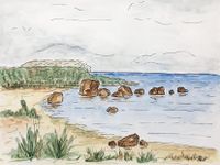
A number of landscape types characteristic of Northern Estonia are represented here, such as the coastal plain and islands of the Gulf of Finland, the plateaus of Harju and Viru and the region of Kõrvemaa with its hills, mires and lakes. The coastline is dotted with peninsulas, bays and small islands. It is the abundance of bays in the area that inspired J. G. Granö, the founder of modern geography in Estonia, to name the region Lahemaa (the Land of Bays) in the early 20th century. In the national park, erratic boulders, including gigantic boulders and boulder fields, are found in great abundance. The most impressive among them is a 400-hectare boulder field in the Käsmu forest, while another similar site, a group of erratic boulders called the Kloostrikivid (Convent Stones) in the Palmse woods, is definitely worth a visit.Communities typical of Lahemaa are sea, forests, mires, semi-natural communities, rivers, lakes and outcrops.Sea makes up one-third of the national park’s surface area. A variety of coastal habitats cover a total of some 8,850 ha. The majority (covering around 6,380 ha) are shallow waters and underwater sand banks. In addition, there are sandy and muddy foreshores which become exposed in windy weather, shallow coastal lagoons which are still occasionally connected to the sea, shallow bays, rocky reefs, coastal berms piled up on the waterfront, shingle and sandy beaches and dunes. There is a variety of beaches in Lahemaa. Sand ryegrass with bluish-grey, sharpedged leaves, sea sandwort and sea pea, a protected species, all grow on sandy beaches. Further inland where the sand is more stable, it becomes covered in lichen, and in some places crowberry takes root, giving the dunes a grey-and-russet appearance.
-
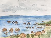 Rocky beach
 -
 geomorphology map
 -
 Erratic boulders


Land use
In this area there are eight settlements: Loksa, Hara, Kasispea, Vihasoo, Tammispea, Eru, Kotka and Vatku. All these settlements are under Lahemaa national park protection area except Loksa city. There is a good infrastructure between all these villages also to Estonian capital city Tallinn. There is boat connection in Loksa harbor but unfortunately it is not regulary used.
Lahemaa national park is good tourism attractions. In there they offer guided tours and programs in and around Lahemaa National Park. There are nature study trails, beautiful landscapes, cultural heritage, four stunning manor complexes and a diverse coastline.
In Loksa there is passive resource of clay 34,19 ha and passive reserves of sand 34,1 ha. These sand resources is also in Kotka. Reserves of peat resources are in Hara active reserves and the area is 598 ha. There is not much agriculture in this area because it is hard to do this because of restrictions. In Loksa there is unsuitable soil for agriculture, it is sandy and significant amount of forest.
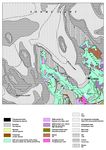
According to Corine land cover map it describes this case study area as:
- discontinuous urban fabric,
- industrial or commercial units,
- coniferous forest,
- mixed forest,
- broad-leeaved forest,
- beaches, dunes, sands,
- indland marshes,
- pastures,
- sea and ocean,
- natural grassland,
- waterbodies,
- peat bogs,
- transitional woodland-shrub,
- land principally occupied by agriculture, with significant areas of natural vegetation.
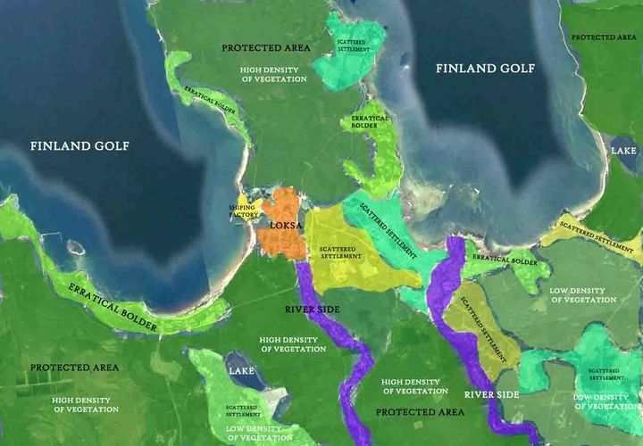
In the future, probably the area is going to be quite same because most of it is under nature protection where are many restrictions for building, agriculture etc. These restrictions are limiting the area development but they can advance tourism, which brings people to this area and raises the potential for economic growth. In Loksa maybe they are going to use more of this harbor because of its beneficial placement of port harbor and develop sea routes. Also, Loksa can be popular among tourists for its housing and food benefits.
-
 land use map

Green/blue infrastructure
- What are the major potential elements of a green/blue infrastructure network? Are these likely to change/disappear? Why is that?
- You find my background material on green infrastructure in our reading list
- add 1-2 graphical representations to the image gallery, you can add more if you like
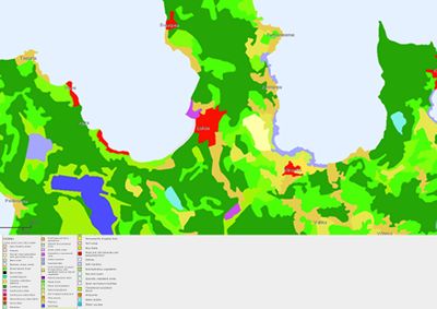
Lahemaa National Park hold significant value for many spices with forests and bogs untouched by human activities. The national park was established to protect typical landscapes of Northern Estonia. Wooded areas in Lahemaa are predominantly unaffected by human activity. Vast territory with untouched forests, bogs, lakes and many rivers together with variable gulfs and peninsulas create stunning landscape to visit.
Loksa and Lahemaa green infrastructure network comprise peninsulas, few islands, forests, meadows, grasslands, stony and sand beaches. At least 18 different hiking and study trails cover the coastal landscape of Lahemaa. Green infrastructure elements in Lahemaa are likely to change as natural process in nature. Human activities has an impact to Loksa and Lahemaa nature, but the goal is to keep parts of the park as they were in old times.
Loksa and Lahemaa waterbodies cover all the national park. Uncountable number of streams are flowing through the park and connecting bigger rivers, lakes, mires, bogs and sea gulfs into blue infrastructure network.
As a part of the green and blue infrastructure Lahemaa National Park is connected with other Estonia wildlife reserves.
Major elements of a green infrastructure network in Lahemaa:
Island and peninsulas:
- Hara island
- Mohni island
- Juminda peninsula
- Pärispea peninsula
- Käsmu peninsula
Mires and bogs:
- Viru bog
- Lohja mire
- Vanasilla Bog
- Harasoo
- Laukasoo
- Pudisoo
- Karupõllu mire
Beaches:
- Turbuneeme beach
- Tapurla beach
- Pärispea beach
- Virve beach
Hiking trails:
- Beaver trail (1 km)
- Oandu natural forest trail (4.7 km)
- Oandu plant trail (1 km)
- Oandu heritage culture trail (3.4 km)
- Altja nature and cultural history trail (3 km)
- Ojaäärse forest trail (3.5 km)
- Trails on Käsmu Peninsula
- Viru bog study trail (3.5 km)
- Majakivi-Pikanõmme study trail (7 km)
- Tsitre tree trail (0.5 km)
- Mohni study and hiking trai
- Coastal nature study trails on Pärispea Peninsula (Hara Bay study trail (3.3 km), Pähkneeme study trail (1.6 km), Purekkari study trail (1 km))
- Võsu cultural history trail (3 km)
- 40-kilometre section of the RMK Oandu-Aegviidu-Ikla hiking route passing through Lahemaa National Park
- The Oandu-Võsu hiking trail (9.5 km)
- The Võsu-Nõmmeveski hiking trail (18 km)
- The Nõmmeveski-Liiapeksi hiking trail (16 km)
- Kolgaküla health trails (longest option: 10 km)
Major elements of a blue infrastructure network in Lahemaa:
Sea gulfs:
- Hara gulf
- Eru gulf
- Kolga gulf
- Käsmu gulf
Rivers and streams:
- Kahala river
- Valgejõgi (river)
- Lohja river
- Oja river
- Kotka river
- Loobu river
- Kolga river
- Loo river
- Käsmu river
- Võsu river
- Pudisoo river
- Altja stream
- Mustoja stream
Lakes and pounds:
- Loksa pounds
- Maalaht
- Ulglaht
- Lohja lake
- Käsmu lake
-
![North-Estonian recreation area: Lahemaa National Park Hiking trails Map[[1]]](/images/thumb/8/87/Lahemaa_matkarajad.JPG/200px-Lahemaa_matkarajad.JPG) North-Estonian recreation area: Lahemaa National Park Hiking trails Map[[1]]
North-Estonian recreation area: Lahemaa National Park Hiking trails Map[[1]] -
![Lahemaa National Park green and blue infrastructure[[2]]](/images/thumb/1/18/Lahemaa_kaart.JPG/200px-Lahemaa_kaart.JPG) Lahemaa National Park green and blue infrastructure[[2]]
Lahemaa National Park green and blue infrastructure[[2]] -
![Viru bog from the tower[[3]]](/images/thumb/5/58/Viru_bog.JPG/200px-Viru_bog.JPG) Viru bog from the tower[[3]]
Viru bog from the tower[[3]] -
 Lahemaa National Park, by Henry Laupmaa
 -
![Braun bear in Lahemaa[[4]]](/images/thumb/a/a3/Pruunkaru.JPG/200px-Pruunkaru.JPG) Braun bear in Lahemaa[[4]]
Braun bear in Lahemaa[[4]] -
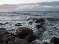 Stony beach in Lahemaa
 -
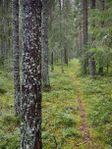 Hiking trail in Lahemaa pine forest
 -
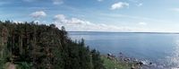
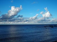 View onto the sea
![North-Estonian recreation area: Lahemaa National Park Hiking trails Map[[1]]](/index.php?title=File:Lahemaa_matkarajad.JPG)
![Lahemaa National Park green and blue infrastructure[[2]]](/index.php?title=File:Lahemaa_kaart.JPG)
![Viru bog from the tower[[3]]](/index.php?title=File:Viru_bog.JPG)

![Braun bear in Lahemaa[[4]]](/index.php?title=File:Pruunkaru.JPG)


Actors and stakeholders
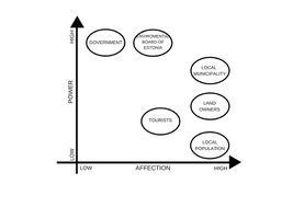
- Who is driving changes in this landscape? Who is affected by those changes?
- Draw a stakeholder and/or power map: Who is affected highly but with low power? Who has high power but is not affected?
State Forest Management Centre (RMK) has been involved in visitor management in the Lahemaa National Park since February 2009. Protected area manager is enviromental board of estonia and the last one drives the changes in this landscape. They give permission to build something on this nature protection area. In Loksa the municipality gives permission to drive changes in Loksa.
-
 power map

Sacred spaces and heritage
- Which places/elements hold cultural value and to whom?
- You may add a map and some images, please also explain in your caption why these elements are valuable
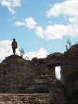
In Lahemaa, traces of human activity date back to the Middle Stone Age. The area has been permanently settled for 4000 years and landscapes here have been preserved in their original form for centuries.The national park encompasses the territories of three parishes (Kuusalu, Kadrina and Haljala) which stand out for their rich folk culture heritage. As far as is known, five dialects were spoken by the locals here, with modern standard Estonian evolving on the basis of the middle-North Estonian dialect, while a great number of folk songs and popular sayings have been recorded in the North-Eastern dialect. The park’s village landscapes and architecture are multi-layered – here, traditions spanning thousands of years as well as innovations created by creative minds exist side by side. Typically, the whole village would get involved in all activities, whether major works or celebrations. People sang when on the village swing, during festivities, at weddings and funerals, to their children and when working.People sang when on the village swing, during festivities, at weddings and funerals, to their children and when working. Creation myths in runic verse originating in these coastal areas have been associated with those known from the Finnish national epic Kalevala.
Many Estonian folk dances have been recorded in this region. Locals used to dance to the music of the bagpipes, violin and diatonic accordion. Farming, raising livestock and fishing have been traditional sources of livelihood in these areas. All of the necessary objects were made by specialised craftsmen. The people here were able to forge iron objects and build ships. Worship and heritage sites known from folk beliefs were inspired by erratic boulders, the tips of capes, stones, trees and springs. So-called wishing stumps and fish chapels were distinct features characteristic of the coastal regions in the area.
-
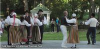 Folk dancers in Lahemaa, Toomas Tuul
 -
 add a caption
 -
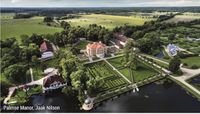 Palmse Manor, Jaak Nilson


Visual appearance and landscape narrative
- Which elements are essential for the landscape character?
- Has the landscape been painted or otherwise depicted, when and whom? Which elements are essential?
- Which narratives exist? Who has written about this landscape or depicted it in some way?
- You can add text and images
Lahemaa is perfect for a nature watching becauce its natural and cultural diversity. Here you will find stony and sandy seashores, picturesque bogs, pine and cliff forests, rivers that cut into the limestone cliff as well as erratic rocks left over from the last Ice Age. Also the coastal area is rich in peninsulas and bays. The bays have versatile bottom relief, are generally deep and there are plenty of submerged rocks and islands.
Lahemaa national park is popular among hobby photographers and painters beacause of its natural diversity. Also enviromental board of Estonia arrange different competitions about it. Last one was about “My home Lahemaa”, task was to draw or take pictures about Lahemaa. Best pictures was awarded. There were one architectural competition about 21. Century home in Lahemaa. They had to design modern Estonian country house taking into account the spatial and cultural characteristics of Lahemaa and Estonian village architecture. There are many literature about Lahemaa. Many story telling and history books. Some poems about it. Like Andrus Norak wrote about Lahemaa and it was published in children magazin Täheke.
-
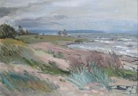 "Lahemaa beach" oil, hardboard 1998 (49x70 cm)/Kalju Nagel - Kunst /erakogu ( private collection)
 -
 poem about lahemaa,Andrus Norak
 -
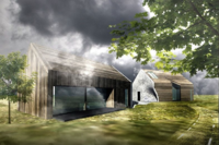 architectural competition in Lahemaa


A.2 Summary of you landscape system analysis and your development Targets
- You can summarize your findings with an DPSI(R) Model or a Spider Diagram
- Link back to the Sustainable Development Goals: Which goals are at risk?
- What is your hypothesis for this landscape?
- Visualise your hypothesis with one graphic/pict
- Are there any existing initiatives taking action in this landscape? Do you have a critical perspective on that?
- Add text and visuals
Summary of DPSIR framework:
Driving forces:
- Tourism
- Climate change
- urbanization (Dense settlement)
- popularity rise
Impacts:
Where coastal development uses and activities are not compatible or are not managed proactively and effectively, there can be loss of property, loss of public values, and damage to important infrastructure. This may restrict public access to varying degrees, impact on natural character and coastal landscapes, increasing the risks from natural hazards, affect coastal historic heritage, impact on coastal biodiversity and the special relationship of tangata whenua with the coastal environment. New and existing coastal developments can adversely can be a result of losing access to cultural resources (physical access and ability to harvest resources). Coastal development can result in increased competition for resources for customary use.
Pressures:
- Human activities (recreational purposes like: hiking, water activities etc)
- Pollution
- climate change : New pest species are likely to occur as a result of climate change migratory species are vulnerable to loss of any of the habitats they require, and/or obstructions along their migratory route
- Due to the presence of the sea and rivers in this area there is a lot of soil erosion
State:
Lahemaa National Park was established on 1 June 1971 to preserve, protect, restore, study and raise awareness about the nature, landscapes, cultural heritage and balanced use of the environment of coastal areas in Northern Estonia. Lahemaa belongs to the Natura 2000 European network of protected habitat and bird site. There are approximately 3,600 permanent residents in the area, but in the summer the population of coastal villages increases many times over and it attract tourism from cities in Estonia and near countries. Due to historical sites and cultural programs such as dance festivals and so on, this place is attractive to tourists.under protection area
Responses:
- the appropriateness of an activity
- the functional need for activities to be in the coast
- the reasonably foreseeable need of communities and future generations
- ensuring activities are appropriately located
- Tackling erosion
- goverment of Estonia and Managing conflict will often involve determining what activity takes priority in certain areas
-
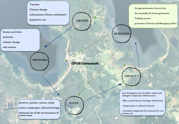 explain your analysis briefly in the caption

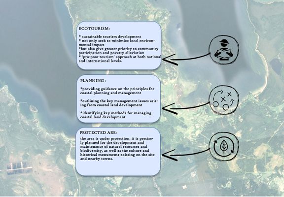
considering the Sustainable Development Goals,the following goals may be at risk:
- 11-sustainable cities and communities
- 13-climate action
- 14-life below water
- 15-life on land
- 16-partnerships for goals
There are many activities that occur within the coastal environment including urban and rural development, transport, infrastructure, energy generation and transmission, food production and mineral extraction. Land on the coast is often limited. here is the potential to have incompatible activities adjacent to each other. Decisions made about coastal land development can also impact on the coastal marine area. Coastal development is a significant issue for the sustainable management of New Estonian’s coastal environment.Coastal development may result in conflicts between uses and activities. Not all uses of the coastal environment are compatible.also,Lahemaa Natural Heritage is working towards the sustainable management of dynamic landscapes and can advise on their management and conservation.
Tourism is one of the largest and fastest growing industries in the world. It is an increasingly important source of income, employment and wealth in many countries. Its rapid expansion has, however, had detrimental environmental (and socio‐cultural) impacts in many regions.new approaches to sustainable tourism development in these countries should not only seek to minimize local environmental impact, but also give greater priority to community participation and poverty alleviation.more emphasis should be given to a ‘pro‐poor tourism’ approach at both national and international levels.
-
 explain your hypthesis briefly in the caption

A.3 Theory reflection
- Reflect on at least three international policy documents in relation to their local landscape case
- choose one international, one European and one national document
- You can choose references from our reading list
- Scope: 250 words
INTERNATIONAL POLICY DOCUMENT
Sustainable development goals
On 1 January 2016, the 17 Sustainable Development Goals of the 2030 Agenda for Sustainable Development. Over the next fifteen years, with these new Goals that universally apply to all, countries will mobilize efforts to end all forms of poverty, fight inequalities and tackle climate change, while ensuring that no one is left behind.
The SDGs, also known as Global Goals, build on the success of the Millennium Development Goals and aim to go further to end all forms of poverty. The new Goals are unique in that they call for action by all countries, poor, rich and middle-income to promote prosperity while protecting the planet. They recognize that ending poverty must go hand-in-hand with strategies that build economic growth and addresses a range of social needs including education, health, social protection, and job opportunities, while tackling climate change and environmental protection.
While the SDGs are not legally binding, governments are expected to take ownership and establish national frameworks for the achievement of the 17 Goals. Countries have the primary responsibility for follow-up and review of the progress made in implementing the Goals, which will require quality, accessible and timely data collection. Regional follow-up and review will be based on national-level analyses and contribute to follow-up and review at the global level.
The seventeen goals are:
- No poverty,
- Zero hunger,
- Good health and well-being,
- Quality education,
- Gender equality,
- Clean water and sanitation,
- Affordable and clean energy,
- Decent work and economic growth,
- Industry, innovation and infrastructure,
- Reduced inequality,
- Sustainable cities and communities,
- Responsible consumption and production,
- Climate action,
- Life below water,
- Life on land,
- Peace, justice and strong Institutions,
- Partnerships to achieve the Goal.
EUROPEAN POLICY DOCUMENT
Convention on the protection of the marine environment of the Baltic sea area
The 1992 Helsinki Convention entered into force on 17 January 2000, after the ratification instruments were deposited by the European Community, Germany, Latvia and Sweden in 1994, by Estonia and Finland in 1995, by Denmark in 1996, by Lithuania in 1997, and by Poland and Russia in November 1999. The Convention covers the whole of the Baltic Sea area, including inland waters as well as the water of the sea itself and the sea-bed. Measures are also taken in the whole catchment area of the Baltic Sea to reduce land-based pollution.
This one reflects with Gulf of Finland. This policy document relates to this study area because northern side of our area is surrounded by the Gulf of Finland and this document also covers the surrounding rivers, streams, lakes. If there is pollution in the water then surrounding nature like birds, animals, fishes is also affected.
NATIONAL POLICY DOCUMENT
National spatial plan Estonia +2030
The green infrastructure strategy aims to preserve or recreate a system of functioning green areas and facilities that are cohesive and sufficiently compact at various geographical levels, enable species to migrate and adapt to climate change, enrich the living environment of people, and support ecosystem services and benefits.
A.4 References
- http://www.loksalinn.ee/tutvustus-ja-asukoht
- https://land.copernicus.eu/pan-european/corine-land-cover/clc-2012/view
- Suuroja, K., All, T., Kõiv, M., Mardim, T., Morgen, E., Ploom, K., Vahtra, T., 2002. Eesti geoloogiline baaskaart (mõõtkavas 1:50 000). 7322 Loksa. Seletuskiri, 85.
- http://loodusegakoos.ee/kuhuminna/rahvuspargid/lahemaa-rahvuspark
- https://www.puhkaeestis.ee/et/ponevad-paigad/pohja-eesti/lahemaa-rahvuspark
- Lahemaa National Park Harju and Lääne-Viru County, www.keskkonnaamet.ee
- http://www.loksa.ee
- https://www.visitestonia.com/en/nature-trip-to-lahemaa-national-park-1
- http://maaleht.delfi.ee/news/maaleht/uudised/vaata-sellised-majad-voivad-kerkida-lahemaale?id=65174410
- https://kaitsealad.ee/eng/nature-6
- http://www.eestiloodus.ee/artikkel3889_3850.html
- https://eesti2030.files.wordpress.com/2014/02/estonia-2030.pdf
- A new approach to sustainable tourism development: Moving beyond environmental protection/https://doi.org/10.1111/1477-8947.00056
Phase B: Landscape Evaluation and Assessment
B.1 Assessment Strategy
- Based on the hypothesis derived from your previous landscape systems analysis you are now asked to define the goals for assessing the landscape. Your assessment is the basis for evaluating the landscape status.
- Which elements and phenomena need to be mapped, why and how?
- This a text contribution, max 250 words
According to phase A, system analysis and drivers, impact, pressure, state and responses in Loksa and Lahemaa. If we want to investigate both parts, we should consider separate hypotheses in the industrial town (Loksa) and protected park (Lahemaa). The most important thing in this area is how we can connect Loksa which is industrial town to Lahemaa which is a protected national park and pressure and influence between Loksa and Lahemaa, how we can preserve the boldet of Lahemaa.
Our hypothesis in part A is how we can approach to Eco-tourism in this area.
According to our goal we are trying to have a landscape character assessment map which is shows different character assessment informs and individual development proposals, by informing landscape.
After LCA we are trying to define ecosystem services and show are they working well or not.
We have different layers for ecosystem services: tourism, social/cultural…
As a conclusion for layers we are trying to evaluate layers and achieve ti problems and potential in this area.
B.2 Mapping
- As defined by your assessment strategy you conduct the mapping and present your findings here
- As a minimum, at least three different themes need to be mapped, you may choose more if needed
-
 landscape character
 -
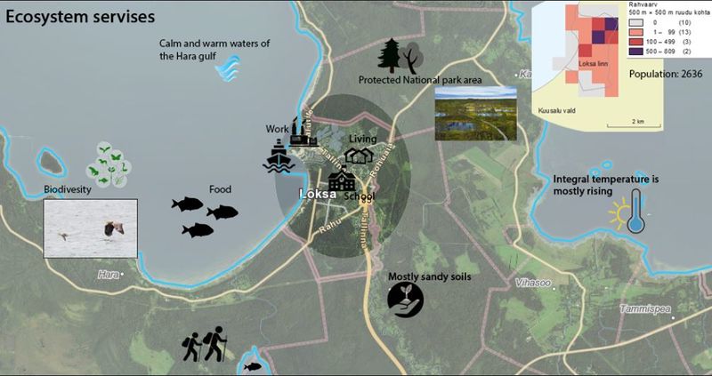
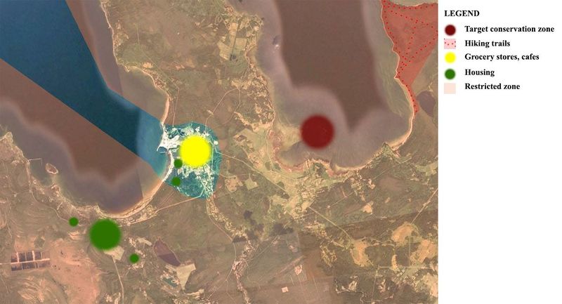 ecosystem services: tourism This area is a very attractive place for tourism. Unfortunately, there are not many places to stay for a night or have a lunch. In this map, there is a yellow area which means there are many grocery stores but only one cafeteria. These places are only in Loksa, so there is no place for tourists to get quick lunch. Green dots mean housing areas, one guesthouse and many different apartments what people rent out for daily visiting. Also, there is possible to stay long term. The dark red area is target conservation zone what you can't visit April to July because of the breeding season of birds. The light pink area is restriction zone, where you can stay but still follow ethical rules. Only hiking trail for tourists is at Käsmu. There you can hike and observe nature by bike.
 -
 Ecosystem services methods limitations are decreasing population, unatractive or missing tourism facilities and not developing urban planning.


B.3 Problem definition and priority setting
- Give a summary of the major findings of your mapping process, what are the problems/potentials identified?
- Draw a problems/potentials map
- Set priorities for the most relevant issues
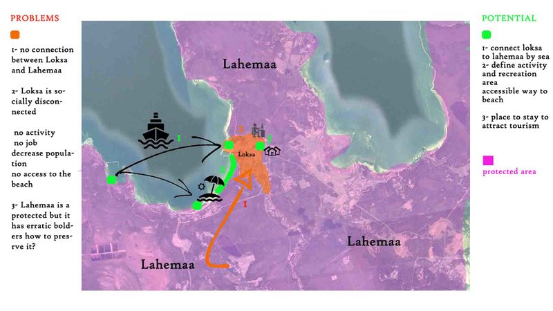
According to landscape character assessment and ecosystem services we found following problems and potentials:
Lahemaa in a protected are then we focused on Loksa which is industrial town and how we can develop area according the connection between Loksa and Lahemaa.
Loksa it’s not protected and Lahemaa is surrounded it. There is some pressure from Loksa to Lahemaa because it is industrial town and there are no recreation activities there. As it is a border, it can be a market and be attractive for tourism to stay in Loksa and spend time in Lahemaa.
The problem is how we can connect Loksa to Lahemaa, we found one ship factory since soviet time, it can be the bolder between Lahemaa and Loksa, we can connect them as you can see in the map.
As Loksa is socially disconnected, there is no opportunity to find a joband working, since 1990 population of it decrease.
There is no activity there for free time and no access to the beach.
There are some heritage sites that they could attracted tourism and improve economy situation in Loksa overall driving force in this topic is changing the market there.
-
 problems and potentials
 -
 idea target


B.4 Theory reflection
- Please reflect the assessment and evaluation methods used based on at least three readings
- Did you encounter limitations'
- 200 words test contribution
Used methods:
- Landscape characteristics assessment- This method gave us an opportunity to get an overview of our area. We found out zones that need more attention and developing. Also poor connections game out. This method is good to get a quick and trustable overview. Unfortunately, this method doesn't go deep down to the problems but it gives good overview.
- Ecosystem services- are the many and varied benefits that humans freely gain from the natural environment and from properly-functioning ecosystems. Such ecosystems include, for example, agroecosystems, forest ecosystems, grassland ecosystems and aquatic ecosystems. Collectively, these benefits are becoming known as 'ecosystem services', and are often integral to the provisioning of clean drinking water, the decomposition of wastes, and the natural pollination of crops and other plants.
B.5 References
- http://www.loksalinn.ee/aktiivne-puhkus
- https://xgis.maaamet.ee
- https://www.airbnb.com/s/Loksa--Loksa-linn--Estonia/homes?adults=1&children=0&infants=0&query=Loksa%2C%20Loksa%20linn%2C%20Estonia&place_id=ChIJz427VNaqk0YR0GH8GG2zAAQ&refinement_paths%5B%5D=%2Fhomes&allow_override%5B%5D=&s_tag=RSiFEaWi
- https://www.google.com/maps
Phase C – Strategy and Master Plan
C.1 Goal Setting
- Define strategic planning objectives based on the evaluation findings
- Link back to your original targets from section one and the Development Goals
- 150 words text contribution
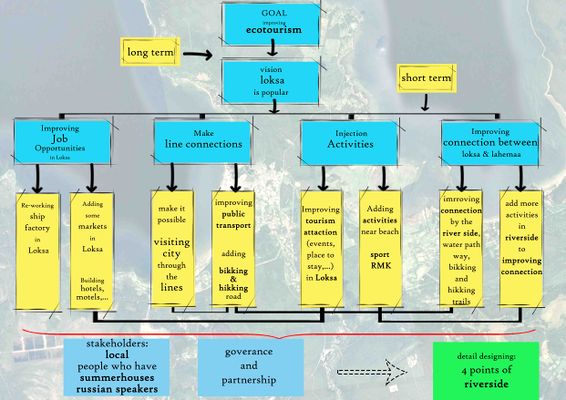
vision: make loksa popular
slogan:" rise from the aches"
job:
improving job possibilities in order to increasing opportunity of local people and people in other cities in Estonia. to making the city more popular, for instance the factories might have potential for investing in the way of restoration or rehabilitation that people work there. providing some hotel and places to stay not only is attraction for tourism but also is job opportunity for people in Loksa.
line connections:
as the vision is about ecotourism and and how to make loksa more popular, it requires connection between Loksa and Lahemaa and coast line near loksa which the lack of accessibility is problematic in this area. by improving line connection that would enhance the accessibility for tourism to visit the city the lines ( public transportation, bicycle road, …) between loksa and lahemaa and beach(coast line) which help the connection .This objective is linked to the goal 16 partnerships for goals.
activities:
tourism attraction, for instance sport activities that includes beach sports (volleyball, jet ski, surfing,...) and some place for picnic near the beach and coastal lines (RMK) would attract tourists. More ever, as the lahemaa is protected area providing some places for staying in loksa would improve possibilities for tourists to stay in the city which might help the economy of the city. in addition improving the market would be helpful.This objective is linked to the goal 11 sustainable cities and communities
connection between Loksa and Lahemaa:'
improving connection between them by riverside, water path way and biking and hiking trails.
the main idea is add more activities around the riverside to make it popular and improving the connection between city(Loksa) and Lahemaa.
This objective is linked to the goal 14 life below water and goal 15 life on land.
C.2 Spatial Strategy and Transect
- translate your strategic goals into a vision
- develop a spatial translation of your vision
- exemplify your vision in the form of a transect with concrete interventions
- add map(s) and visualizations
-
 draft strategy tree
 -
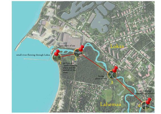 Transect map
 -
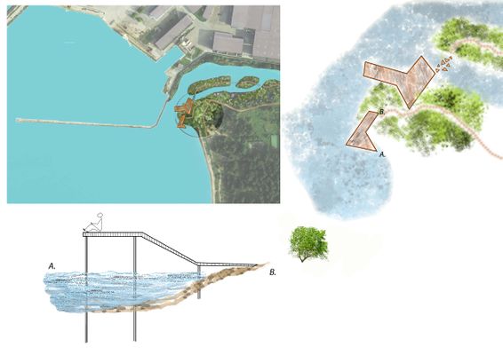 Detail 1: Platforms with a view to the sea and river delta
 -
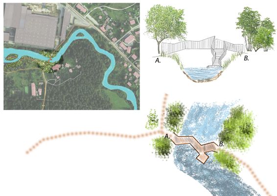 Detail 2: Bridge and stairs down to the platform
 -
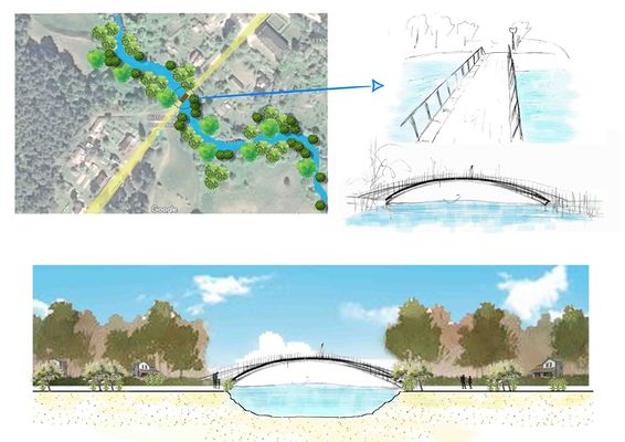 Detail 3: Bridge
 -
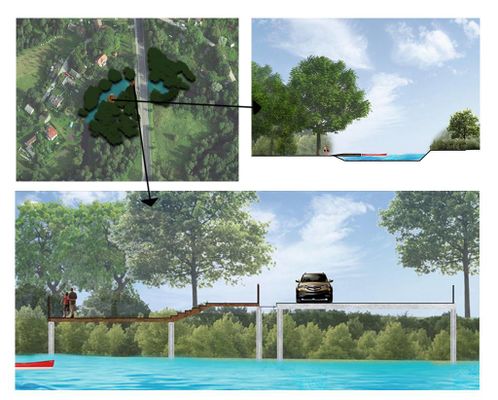 Detail 4:platforms


C.3 From Theory of Change to Implementation
- For implementing your vision: Which partnerships are needed? Which governance model is required?
- Who needs to act and how? Draw and explain a change/process model/timeline
- Which resources are needed? On which assets can you build?
- add 150 words text and visuals
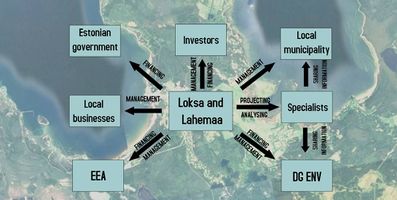
Lahemaa is under nature protection and there is Natura 2000 network, this area is regulated by EEA and DG ENV. But the management should be done by the local authorities and municipality, who are more related and interested in this site. Also, non-governmental people should join in and do something to attract visitors.
For designing and constructing this design on Loksa and Lahemaa, there are involved several parties. Architects are hired for designing and planning the landscape. When they are planning and designing they have to involve environmental inspectorate, Estonian rescue board, Estonian road administration and local municipality to accept the project.
Project financing comes from national government and local municipality. Also, if some investors want to develop something in there they should also finance it.
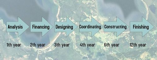
The planning process is divided into phases. The first phase is analysis what is conducted by experts. The second phase is to find finances for these projects. The third phase is designing process. The fourth phase is to coordinate these designs with different agencies. The fifth phase is to start constructing these projects and the sixth phase is to finish all the projects. It all has to be ready in 2030.
-
 Governance model
 -
 process model


![[2]](http://www.keskkonnaamet.ee/public/lahemaa_skeem_151003_1024_737_1.jpg)
C.4 References
- give a full list of the references you have used for this section
- https://www.google.com/maps
- http://xgis.maaamet.ee/xGIS/XGis
D. Process Reflection
- Reflect in your intercultural and interdisciplinary team on the outcomes of your study
- Which limitations were you facing?
- What have you learnt from each other?
- What would you do differently next time?
- You can also use diagrams/visuals
- 250 words text
In our group, there were three people. The starting of the teamwork was a bit rocky, but at the end were all smooth and cleared out even if we were not in the same country. Big thanks to our lecturer who helped and guided us at the right direction. Also answering all the questions and limitations which we have encountered.
There were some limitations, but all of them we overcome. The first limitation was to find the right time when all of us can consultate, share ideas, discuss and fix already done work.
What would we do differently next time? Maybe we should communicate more, but overall we think at the end we managed the team work well.