Fusaro Lake-Cuma Coast: Difference between revisions
| (23 intermediate revisions by 3 users not shown) | |||
| Line 168: | Line 168: | ||
*To estimate the range of ''benefits and services'' that the ecosystem offers in order to make the most out of the local products and to manage at best the resources. To achieve this first goal, the ''Ecosystem Services method (ES'') comes handy. | *To estimate the range of ''benefits and services'' that the ecosystem offers in order to make the most out of the local products and to manage at best the resources. To achieve this first goal, the ''Ecosystem Services method (ES'') comes handy. | ||
*To define the ''risks'' that threaten the costal landscape as well as the ''values'' which give potential to the area, so that it comes easier to operate in order to restrain the danger and enhance the potentials. | |||
*To understand the ''main features and appearance'' of the coast for the purpose of improving the coastal landscape. The ''Coastal Character Assessment (CCA)'' can help in the mapping of these elements. | *To understand the ''main features and appearance'' of the coast for the purpose of improving the coastal landscape. The ''Coastal Character Assessment (CCA)'' can help in the mapping of these elements. | ||
The result of these assessments will be a clear picture of the landscape actual status, the starter point for the planning phase. | The result of these assessments will be a clear picture of the landscape actual status, the starter point for the planning phase. | ||
== B.2 Mapping == | == B.2 Mapping == | ||
<gallery caption=" " widths=" | <gallery caption=" " widths="500px" heights=400px" perrow="1"> | ||
File:mappa 1.jpg|'' | File:mappa 1.jpg|'' This map shows the resources present on the territory such as maritime species, wine and agricultural products, the presence of green areas, the metropolitan line that connects the center of Naples to the Fusaro Lake area, the presence of hotels that allow the tourism increasing, along with restaurants and shops. '' | ||
File:mappa 2.jpg|'' | File:mappa 2.jpg|''This map highlights, for the various areas such as the '''lake area''',the '''sea''' and the '''urban''' one, the negative and positive aspects. The negative aspects from a planning point of view, must be overcome with solutions. The positive aspects of the territory such as the interest of tourism along the coast and the lake, the presence of cycle paths near the lake, the archaeological heritage, must be seen as potentials on the area to be protected and improved.'' | ||
File: | File:CCA.jpg|''This tab shows the characteristics of the territory, the landscape values of the area, the human activities, the resources of the territory.'' | ||
</gallery> | </gallery> | ||
== B.3 Problem definition and priority setting == | == B.3 Problem definition and priority setting == | ||
<gallery caption=" " widths=" | |||
File: | <gallery caption=" " widths="600px" heights="400px" perrow="5"> | ||
File:Problems potentials PRIORITIES.jpg|''add caption here'' | |||
</gallery> | </gallery> | ||
| Line 210: | Line 206: | ||
=Phase C – Strategy and Master Plan = | =Phase C – Strategy and Master Plan = | ||
== C.1 Goal Setting == | == C.1 Goal Setting == | ||
The different mapping carried out during the previous phase, allowed us to follow a clearer path for the development of an efficient goals setting. In particular, the evaluation findings led us to the definition a '''«small actions, great (positive) impacts»''' approach, given the vulnerability of the land, mainly oriented to the exploitation of what the land already offers. | |||
*'' | So our strategic planning, also according to the Sustainable Development Goals, consists of four main objectives: | ||
* '' | |||
*The development of the '''Cuma Archeopark''', improving the accessibility to the area and with the purpose of enhancing slow tourism. This first goal is not only related to the creation of an economic source but also to the promotion of the cultural heritage and of the local identity. | |||
*To protect and to increase the value of the '''Licola Dunes Coast''', creating routes of blue, mobility to connect the areas of major interest along the coast, and reconstructing the dunes following a sustainable model; this aim seek to the enhancing of the natural heritage and is strongly linked to the ''Development Goals number 14: «Conserve and sustainably use the oceans, seas and marine resources» and number 13: «Take urgent action to combat climate change and its impacts».'' | |||
*The creation of a '''Fusaro Lake Reserve''', with the main purpose of a naturalization of the lake area and the regeneration of the bank to install pedestrian paths and water activities. This target, as for the previous ones, seek to different results: improve tourism, in order to heal the local economy; preserve the water and land biodiversity; promote the natural landscape. These decisions were mostly guided by the ''Development Goals number 14: «Conserve and sustainably use the oceans, seas and marine resources» and number 15: «Sustainably manage forests, combat desertification, halt and reverse land degradation, halt biodiversity loss».'' | |||
*The last goal is about the creation of a '''Green Mobility Network''' which allows to connect the main spots along the coastal area. The idea is both to make it easier to reach the attraction areas and to promote a sustainable way of exploring the coastal area. Again, this objective is linked to the ''Development Goals number 13 and 14, but mainly to the number 11: «Make cities inclusive, safe, resilient and sustainable».'' | |||
== C.2 Spatial Strategy and Transect == | == C.2 Spatial Strategy and Transect == | ||
<gallery caption=" " widths=" | The area of the Cuma Coast is, luckly, not much urbanised; since the main cities center are on the opposite side here the land use is mainly dedicated to agriculture and few family houses or farms so it has a great potential of development. Our general idea focuses on the need to give an "update" to the area, releasing its full potentials connected to the natural and archeological resources. Through our transect we set our main focus points: | ||
File: | |||
File: | * The '''Cuma ArcheoPark''': here the idea is to free the site from illegal building, proceed with the archeological excavations kept on hold and making the ArcheoPark easier to reach thanks to green mobility connections (bike paths, electric busses, etc.); | ||
File: | *The '''Fusaro Lake Reserve''': it will be a filter "wall" between the urbanised areas and the Cuma coast. The plan is to create a green belt around the lake, with pedestrian and bike paths connected to the main roads, in order to make the Reserve easily accessible from everywhere with light transportation systems. Thanks to the integration of local and suitable species (both plants and animals), the reserve will flourish as an attraction for nature lovers, birdwatchers, etc. The Casina Vanvitelliana will serve the porpouse as starting point for every activity. On the lake will be possibile to practise acquatics activities or just have a boat tour. | ||
*the '''Licola Dunes Coast''': this intervention will focus on a complete clean up of the coast, removing every unmovable structure, prefering the seasonal ones, designing a coastal car road with bike paths serving the beach activities and reconstructing the dunes erased. In the southern part of the area a new harbour dedicated to private boats will be built jointly with facilities such as hotels. Two more docks will be built along the coast to serve as stops for the bus/taxi boats. | |||
<gallery caption=" " widths="800px" heights="500px" perrow="1"> | |||
File:Transectfusaro.jpg|''The transect explain clearly the point on which we have decided to focus for our projects'' | |||
File:Projectidea.jpg|''The maps explain the agopunctures interventions decided'' | |||
File:Viewgenerl.jpg|''A visual of what should the general mood feel like. A bike path running alongside the lake Fusaro, removing illegal structures and making space for general frution'' | |||
</gallery> | </gallery> | ||
== C.3 From Theory of Change to Implementation == | == C.3 From Theory of Change to Implementation == | ||
<gallery caption=" " widths=" | Based on the study of similiar operations running in other cities in Italy we understood that the main channels for realising these kind of projects are two: public and private. Since our area is not part of just one municipality, a joint venture between the city of Pozzuoli and the city of Bacoli is needed. Jointly the could work to define the masterplan and setting the priorities. Based on our research we found that this kind of interventions could be funded by the European Union; currently, infact, the Campania Region is beneficiary of several thousands of million of euros of funds part of the 2014/2020 balance programme. The cities interested in these funds are needed to set an esecutive project and nominate it for these funds. The Region and the Union will then decide wherever the proposal is suitable to receive the funds or not. These money could fund the interventions on the Cuma Archeopark, the lake reserve and the coastline. Private entrepreneurs could, instead, fund the construction of the hotel and the other facilities through a "project financing" which allow this kind of partnership between public and private. | ||
File: | |||
File: | The timeline we set is on 10 years, starting on 2020. The interventions are not that difficult to realise so we figured out that 5-7 years could be a realistic time range to realise everything. | ||
<gallery caption=" " widths="800px" heights="500px" perrow="1"> | |||
File:Ok.jpg|''Relationships between the main actors involved'' | |||
File:Timelineprogress.png|''Possible timeline for the interventions'' | |||
</gallery> | </gallery> | ||
== C.4 References == | == C.4 References == | ||
* | * [http://porfesr.regione.campania.it/it/news/primo-piano/por-campania-fesr-2014-2020 POR CAMPANIA FESR 2014-2020] | ||
= D. Process Reflection = | = D. Process Reflection = | ||
Latest revision as of 18:38, 14 June 2018
>>>back to working groups overview
| Area | Fusaro Lake-Cuma Coast | |
| Place | Bacoli | |
| Country | Italy | |
| Topics | Green development, heritage protection and tourism improvement | |
| Author(s) | Angela Ruggiero, Angela Vicidomini, Giacomo Santoro, Lucia Turiello | |

| ||
Rationale
The area of the Cuma Coast is one of great interest in the surroundings of Naples. Within its borders there are several emergencies concerning architecture, archeology and natural environment. Here the coastline is quite different, with wide sand beaches and traces of dunes so it has great potential to improve tourism. The inner part is quite chaotic due to illegal construction and messy urban planning. The idea is to rebuild the natural environment and create new and sustainable infrastructures in order to exploit at best the resources.
Location and scope
You can edit this map with the map editor
A Landscape System Analysis
A.1 Landscape layers and their system context
Geomorphology, landscape units and coastal typology
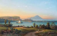
The area of study is part of the larger volcanic area of the Phlegraean Fields (Campi Flegrei in italian). The area of the caldera consists of 24 craters and volcanic edifices which have deeply transformed during the centuries. Despite the super volcano is dormant, hydrothermal activity and effusive gaseous manifestations can be currently observed. The Acropolis of Cuma is itself part of one of the craters. The Fusaro Lake is, instead, a volcanic lake which formations is due to the blockage of volcanic materials which created a narrow coastal strip. The coastline is characterized by wide sand beaches with sand dunes and is currently menaced by erosion.
-
 Aerial view of the Campi Flegrei. On the background the Cuma Coast with the Fusaro Lake

Land use
Beyond the costal belt, this particular area of the Phlegraean Fields is mainly occupied by agricultural fields and green areas. Especially the zone behind the coastline is characterized by the Natural Reserve of the Licola Coast and the Quarantena Natural Park, placed beside the Fusaro Lake. Only the remaining surface is taken by few residential buildings: the settlements are mostly messy and old, despite Bacoli great potential. The area used for agriculture could be the most likely to change because of the housing need, but it really is a protected area which can't be built to protect the biodiversity and the specific plantations. Cuma Coast is also rich of archeological sites which ,together with the costal landscape, are the main resources for a tourism improvement. These characteristics make Bacoli an ideal place for holidays; in fact, since its Roman foundation, the city has always been used as a vacation site. The area is also provided with three different stops of the Circumflegrean line, making it easy to reach both the lake and costal areas.
-
 Land use

Green/blue infrastructure
It is clear how the study area holds a great environmental value, made by an intertwinement between nature, history and agricultural use: this is what makes the Cuma Coast a perfect scene for the creation of green and blue infrastructure, also according to the Bacoli 2004 P.U.C. (Municipality Urban Plan) main goals: sustainability, development of agricultural sites, increase of green areas and reduction of pollution.
- Green Infrastructure
The main elements on which establish a new wide green infrastructure are surely the Natural parks which are a wonderful background for the coast. Together with the parks, the agricultural heritage can also be a useful resource in order to build an infrastructure which involves a great biodiversity. This green infrastructure can be not only the vehicle for a revaluation of the natural assets but also for the cultural and archeological holdings.
- Blue Infrastructure
Surely the leading attraction of this area is the costal landscape, but the Cuma Coast is currently exploited by privates. The creation of new public and innovative services along the coast can improve the summer tourism but can also set up attractions usable the whole year. Obviously, the Fusaro Lake is the other main element that can be the ideal heart of a new blue infrastructure.
-
 Main elements for new infrastructure

Actors and stakeholders
The area is mainly part of the Municipality of Bacoli. The main institutional actors involved are the same Municipality, the Basin Authortity (Autorità di bacino), the Provence of Naples and the Campania Region. Currently the Region is working on a coastline masterplan and, in partnership with the Emilia-Romagna Region, on an european project for the management of the coast. The Basin Authority (Autorità di bacino) is proceeding with the drafting of the Erosion Plans for Coastal Erosion, whose fundamental objectives are the identification of the areas at risk, within the stretch of coast in question, and the definition of guidelines for the implementation of coastal engineering interventions with particular reference to the defense of the areas considered as priority for the presence of high environmental criticalities.
-
 The decision hierarchy cannot be considered univocal. We can say that the Municipality is the main decision maker because is the actor which can take practical decisions. The other actors contribuite to the decisions of the Municipality both with suggestions both with regulamentations. Citizens are, at last, the ones which influence these decision maker with their votes during elections. It can happen, in some cases, that organised criminality could affect decision or take these decision in order to have a personal gain.

Sacred spaces and heritage
The study area holds a special cultural interest, mainly because of the presence of the archeologic site of Cuma. Cuma is one of the oldest Roman colonies settled in Italy, founded in 730 b.C. The site of Cuma, explored in stages since 1606, but systematically only since 1852, is managed by the Superintendence for the Archaeological Heritage of Naples: most of the recovered finds are kept at the National Archaeological Museum of Naples and to the archaeological museum of the Campi Flegrei. Of the ancient city, just partly excavated, is possible to visit the lower part of the Roman city: the area of the Forum with its baths and public buildings, the Crypta Romana, and especially the acropolis with the Sibyl Cave and the Temples of Apollo and of Zeus. The splendid Arco Felice is a gateway to the city, a monumental brick arch from the Roman era.
In the heart of the city of Bacoli, you can also find another little archeologic site, called the "Colombario": it is a funerary building used to save ossuaries but in the past it was disguised as a place to host birds, and that's the reason of the name (colomba is the italian for dove).
The area of the Fusaro lake was one of the favorite hunting sites of Ferdinand IV of Bourbon who, to the south-east of the lake above a small island, gave rise to the beautiful Royal Casino. A jewel of late eighteenth-century architecture, one of the most significant of the Campi Flegrei, the so called "Casina Vanvitelliana" built to a design by Carlo Vanvitelli in 1782.
-
 The Royal Casino is one of the most pictured element in the area
 -
 Cuma
Cuma


Visual appearance and landscape narrative
The Phlegraean Fields have an enormous historical and environmental importance for numerous reasons which makes this part of Campania one of the most fascinating places of Italy. Throughout the centuries, this area has been visited by a lot of people, becoming a great inspiration for famous painters and writers.
If we look at the past, Virgilio writes about it in the “Aeneid” in which Lake Fusaro represents the legendary “Acherusie palus”, that is the infernal marsh formed by the river Acheron. Seneca, instead, describes the residence of Roman Senator Vatia, underlining its favorable position which allowed the view on the sea and an excellent exposure to the winds (Letters to Lucilius, book XX, ep. VI).
This area was one of the destination of the Grand Tour from the seventeenth to the nineteenth century, during which the richest young people of all Europe learned, trough the journey, about art, culture, politics of the other countries. They note what they discovered in their travel diares. Among these, Goethe, in his Journey in Italy, gives a wide description of the area.
"The surroundings of Naples are the most wonderful in the world. The destruction and chaos of the volcanoes incline the soul to imitate the criminal hand of nature ... "We," I said to my friends, "resemble these volcanoes and the virtuous people in the monotonous and desolate Piedmontese plain. »
(Donatien Alphonse François de Sade)
Jakob Philipp Hackert, Goethe’s friend, works in Italy for Ferdinand I, King of the Two Sicilies. He is the painter of “Ferdinand IV chasing coots on the Lake Fusaro”, a documentary canvas on which the sovereign and his court are depicted during a hunting trip, probably in November. The scene is divided in two parts by an enormous tree which gives repair to people on the coast: on the left there’s the court; on the other part there’s the Casina Vanvitelliana, a suggestive hunting lodge made by the Italian architect Luigi Vanvitelli. The canvas is now preserved in the National Museum of Capodimonte.
In the same years, the swiss artist Johann Rudolf Buhlmann paints the “Lake Fusaro with Casina Reale”, too.
Among the Italian artists, Achille Carelli gives us a glimpse of the lake, as it appeared in the XIX century. His point of view includes the ruins of the so-called “Grotte dell’Acqua” which were part of an ancient Roman villa. During XX century to nowadays, Phlegraean Fields are also chosen by famous directors as scene for their films.
-
 Ferdinand IV hunting on the Fusaro lake, Hackert (1783)
 -
 Lake Fusaro with Casina Reale, Johann Rudolf Buhlmann
 -
 Il Lago Fusaro, Achille Carelli
 -
 Il Lago Fusaro, Antonio Pitloo
 -
 Il Lago Fusaro


A.2 Summary of you landscape system analysis and your development Targets
The area is part of a delicate eco-system. According to several researches and studies, by 2100, due to global warming, the sea level will rise and a large part of the italian coastline will be affected and likely disappear. Serious actions are need to be taken in order to prevent this scenario; most of the Sustainable Development Goals can't be pursued locally but the Municipality could work on projects to improve the management of the city and its resiliency. As earlier mentioned, the Regional administration is working on a masterplan to regenerate the coastline but results haven't been disclosed yet.
-
 The area of Bacoli is rich in architectural and cultural elements such as: The archeological site of Cuma, the Crypta Romana, the Sybil cave, The Temple of Apollo and Zeus, the Colombario and a wide presence of green areas and natural parks. Moreover the area is well connected by the Circumflegrea line. Among the negative aspects that this area holds, there is an important issue of air pollution and problems related to car traffic that inreases during the summer season, being this a tourist destination. In addiction there are serious issues caused by illegal waste disposal which makes useless the functioning of water purifiers. For this reason there are work in progress on the purification of water.

-
 The idea is to make the area reactive to climate changes risks and still attractive to tourists and enjoyable for people living there thanks to new facilities and new job opportunities

A.3 Theory reflection
Landscape and costal emergencies are analyzed in different international and national documents, which are about the same challenges the Cuma coast is facing.
Internationally, the Urban Agenda observes the outcomes of a weak urban planning and of an improper territory management, which is what affects the landscape of the Cuma Coast: unsuitable accommodations, pollution and disaster risks. Even if every country has got local peculiarity, the challenges are similar and so are the answers; not only is needed a partnership between national and regional government but also a collaboration within the local society itself. The main goal decided during the Quito conference is to create “livable cities”, which is reachable only thanks to “an accurate resources management, the environmental and cultural heritage endorsing and an infrastructure improvements”.
The Maritime Spatial Planning European Strategy for more Growth and Jobs in Coastal and Maritime Tourism is an important European document. The main interest of it concerns about how human activities at sea could be efficient, safe and sustainable. The Council has adopted a legislation to create a common framework for maritime spatial planning in Europe. The purpose is to reduce conflicts, encourage investments, increase cross-border cooperation, protect the environment. The UE members support the planning by making their own projects to facilitate cooperation between the countries. They focus their attention on themes such as: fishing and aquaculture, energy, maritime tourism, shipping, environment and so on.
Italy legislation is provided, instead, with the Code of Cultural Heritage and Landscape, approved in 2004. By landscape we mean the expressive territory of identity, whose character derives from the action of natural and human factors and their interrelation. With reference to the landscape, the enhancement includes the redevelopment of buildings and areas subject to protection compromised or degraded, or the creation of new coherent and integrated landscape values. The enhancement of the landscape contributes to promote the development of culture. To this end, public administrations promote and support, as far as their respective competences are concerned, specific activities of knowledge, information and training, redevelopment and use of the landscape and, where possible, the realization of new coherent and integrated landscape values.
A.4 References
- Cuma, la prima città greca d'Italia
- Visita al complesso borbonico del lago Fusaro
- Il lago Fusaro
- Il lago Fusaro e le sue ostriche
- Difesa del suolo
- NASA Sea Level Change Portal: Projections
- Codice dei Beni Culturali e del Paesaggio
- Habitat III
Phase B: Landscape Evaluation and Assessment
B.1 Assessment Strategy
In order to define the planning strategy, after defining the main characteristics of the area, it is necessary to take a deeper look at some of the aspects found thanks to the analysis. In fact the landscape system analysis revealed an area with an important cultural and natural heritage but at the same time an area in danger, that’s why it is important to control and locate these elements and phenomena. The assessment of these aspects is essential for the definition of a strategic planning, so the main goals of this evaluation phase are:
- To estimate the range of benefits and services that the ecosystem offers in order to make the most out of the local products and to manage at best the resources. To achieve this first goal, the Ecosystem Services method (ES) comes handy.
- To define the risks that threaten the costal landscape as well as the values which give potential to the area, so that it comes easier to operate in order to restrain the danger and enhance the potentials.
- To understand the main features and appearance of the coast for the purpose of improving the coastal landscape. The Coastal Character Assessment (CCA) can help in the mapping of these elements.
The result of these assessments will be a clear picture of the landscape actual status, the starter point for the planning phase.
B.2 Mapping
-
 This map shows the resources present on the territory such as maritime species, wine and agricultural products, the presence of green areas, the metropolitan line that connects the center of Naples to the Fusaro Lake area, the presence of hotels that allow the tourism increasing, along with restaurants and shops.
 -
 This map highlights, for the various areas such as the lake area,the sea and the urban one, the negative and positive aspects. The negative aspects from a planning point of view, must be overcome with solutions. The positive aspects of the territory such as the interest of tourism along the coast and the lake, the presence of cycle paths near the lake, the archaeological heritage, must be seen as potentials on the area to be protected and improved.
 -
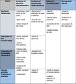 This tab shows the characteristics of the territory, the landscape values of the area, the human activities, the resources of the territory.


B.3 Problem definition and priority setting
-
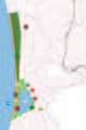
 add caption here

B.4 Theory reflection
Effective and valid methods to evaluate such a complex topic were needed, in order to provide as much informations as possible to have a starting point for the following steps, concerning the development of a startegy to finalise our project.
First, we decided to start with the Coastal Character Assessment (CCA) method, which is an useful tool to analyse the state of the coastline and the contribution of the sea and immediate hinterland to coastal character. The process of coastal character assessment is principally concerned with defining and describing character and not making judgments on coastal sensitivity, quality or value. In this way we had an objective eye on what we are working on.
After this we had an Ecosystem Evaluation, which is a process that gave us the chance to assign a "value" to the services of our ecosystem, mapping the characteristics of the area and to evaluating the benefits which this services could give to our ecosystem.
In the end we set a Risk Potential Assessment Map, which is a tool similar to the one used within business companies. In this way we have divided the area and set which are the main risk which our project could face and the the potential that we can isolate and exploit in our design and study process. In this way we set an overall idea of the target on which we need to focus.
B.5 References
- Guidance on Coastal Character Assessment
- Methodologies for defining and assessing ecosystem services
Phase C – Strategy and Master Plan
C.1 Goal Setting
The different mapping carried out during the previous phase, allowed us to follow a clearer path for the development of an efficient goals setting. In particular, the evaluation findings led us to the definition a «small actions, great (positive) impacts» approach, given the vulnerability of the land, mainly oriented to the exploitation of what the land already offers. So our strategic planning, also according to the Sustainable Development Goals, consists of four main objectives:
- The development of the Cuma Archeopark, improving the accessibility to the area and with the purpose of enhancing slow tourism. This first goal is not only related to the creation of an economic source but also to the promotion of the cultural heritage and of the local identity.
- To protect and to increase the value of the Licola Dunes Coast, creating routes of blue, mobility to connect the areas of major interest along the coast, and reconstructing the dunes following a sustainable model; this aim seek to the enhancing of the natural heritage and is strongly linked to the Development Goals number 14: «Conserve and sustainably use the oceans, seas and marine resources» and number 13: «Take urgent action to combat climate change and its impacts».
- The creation of a Fusaro Lake Reserve, with the main purpose of a naturalization of the lake area and the regeneration of the bank to install pedestrian paths and water activities. This target, as for the previous ones, seek to different results: improve tourism, in order to heal the local economy; preserve the water and land biodiversity; promote the natural landscape. These decisions were mostly guided by the Development Goals number 14: «Conserve and sustainably use the oceans, seas and marine resources» and number 15: «Sustainably manage forests, combat desertification, halt and reverse land degradation, halt biodiversity loss».
- The last goal is about the creation of a Green Mobility Network which allows to connect the main spots along the coastal area. The idea is both to make it easier to reach the attraction areas and to promote a sustainable way of exploring the coastal area. Again, this objective is linked to the Development Goals number 13 and 14, but mainly to the number 11: «Make cities inclusive, safe, resilient and sustainable».
C.2 Spatial Strategy and Transect
The area of the Cuma Coast is, luckly, not much urbanised; since the main cities center are on the opposite side here the land use is mainly dedicated to agriculture and few family houses or farms so it has a great potential of development. Our general idea focuses on the need to give an "update" to the area, releasing its full potentials connected to the natural and archeological resources. Through our transect we set our main focus points:
- The Cuma ArcheoPark: here the idea is to free the site from illegal building, proceed with the archeological excavations kept on hold and making the ArcheoPark easier to reach thanks to green mobility connections (bike paths, electric busses, etc.);
- The Fusaro Lake Reserve: it will be a filter "wall" between the urbanised areas and the Cuma coast. The plan is to create a green belt around the lake, with pedestrian and bike paths connected to the main roads, in order to make the Reserve easily accessible from everywhere with light transportation systems. Thanks to the integration of local and suitable species (both plants and animals), the reserve will flourish as an attraction for nature lovers, birdwatchers, etc. The Casina Vanvitelliana will serve the porpouse as starting point for every activity. On the lake will be possibile to practise acquatics activities or just have a boat tour.
- the Licola Dunes Coast: this intervention will focus on a complete clean up of the coast, removing every unmovable structure, prefering the seasonal ones, designing a coastal car road with bike paths serving the beach activities and reconstructing the dunes erased. In the southern part of the area a new harbour dedicated to private boats will be built jointly with facilities such as hotels. Two more docks will be built along the coast to serve as stops for the bus/taxi boats.
-
 The transect explain clearly the point on which we have decided to focus for our projects
 -
 The maps explain the agopunctures interventions decided
 -
 A visual of what should the general mood feel like. A bike path running alongside the lake Fusaro, removing illegal structures and making space for general frution


C.3 From Theory of Change to Implementation
Based on the study of similiar operations running in other cities in Italy we understood that the main channels for realising these kind of projects are two: public and private. Since our area is not part of just one municipality, a joint venture between the city of Pozzuoli and the city of Bacoli is needed. Jointly the could work to define the masterplan and setting the priorities. Based on our research we found that this kind of interventions could be funded by the European Union; currently, infact, the Campania Region is beneficiary of several thousands of million of euros of funds part of the 2014/2020 balance programme. The cities interested in these funds are needed to set an esecutive project and nominate it for these funds. The Region and the Union will then decide wherever the proposal is suitable to receive the funds or not. These money could fund the interventions on the Cuma Archeopark, the lake reserve and the coastline. Private entrepreneurs could, instead, fund the construction of the hotel and the other facilities through a "project financing" which allow this kind of partnership between public and private.
The timeline we set is on 10 years, starting on 2020. The interventions are not that difficult to realise so we figured out that 5-7 years could be a realistic time range to realise everything.
-
 Relationships between the main actors involved
 -
 Possible timeline for the interventions


C.4 References
D. Process Reflection
- Reflect in your intercultural and interdisciplinary team on the outcomes of your study
- Which limitations were you facing?
- What have you learnt from each other?
- What would you do differently next time?
- You can also use diagrams/visuals
- 250 words text