Constanta: Difference between revisions
| (108 intermediate revisions by 2 users not shown) | |||
| Line 9: | Line 9: | ||
{| align="right" width="400pt" style="background:Gainsboro; color:black" | {| align="right" width="400pt" style="background:Gainsboro; color:black" | ||
|- | |- | ||
| '''Area''' ||style="background:Lavender"| '' | | '''Area''' ||style="background:Lavender"| ''Z3'' | ||
|- | |- | ||
| '''Place''' || style="background:Lavender"|'' | | '''Place''' || style="background:Lavender"|''Constanța'' | ||
|- | |- | ||
| '''Country''' || style="background:Lavender"|'' | | '''Country''' || style="background:Lavender"|''Romania'' | ||
|- | |- | ||
| '''Topics''' || style="background:Lavender"|'' | | '''Topics''' || style="background:Lavender"|''Coastal development; urban coast; urban waterfront'' | ||
|- | |- | ||
| '''Author(s)''' || style="background:Lavender"|'' | | '''Author(s)''' || style="background:Lavender"|''Wendy Laura Cînța, Simona Dolana, Ioana Natalia Oneșciuc, Mihai Surdu'' | ||
|- | |- | ||
| colspan="3" align="center" style="background:silver"| [[File: | | colspan="3" align="center" style="background:silver"| [[File:Keyimage.jpg|400px]] | ||
|- | |- | ||
| ||style="background:Lavender"| | | ||style="background:Lavender"| | ||
| Line 27: | Line 27: | ||
= Rationale = | = Rationale = | ||
The complexity of the | The complexity of the Constanța case study consists in the fact that it, as '''a''' '''big city of Romania''' (of around 300 thousand inhabitants), is at the same time '''a strategic point on a continental scale'''. This is due to the favourable location on one of the most important geostrategic axes of the European continent, '''the Rhine-Danube TEN-T Corridor and the fact that it is the largest port on the entire Black Sea basin'''. | ||
In the context of | In the context of Constanța, the concept of "resource" should not be limited to the port element as an urban development factor, but should be extended to include '''the entire coastline, as a responsible element of increasing the site's quality'''. | ||
= Location and scope = | = Location and scope = | ||
| Line 42: | Line 40: | ||
== A.1 Landscape layers and their system context == | == A.1 Landscape layers and their system context == | ||
=== Geomorphology, landscape units and coastal typology === | === Geomorphology, landscape units and coastal typology === | ||
The shoreline has great stability, but it suffers from a '''continuous but slow withdrawal process, that generates landslides that look like false terraces'''. Erosion, especially due to '''socio-economic pressure''', affects the '''complex geological structure''' of the coastline. | |||
<gallery caption=" " widths="200px" heights="150px" perrow="5"> | <gallery caption=" " widths="200px" heights="150px" perrow="5"> | ||
File: | File:Landscapeunits.jpeg|''Geomorphology, landscape units and coastal typology'' | ||
File: | File:Landscapeunits2.jpg|''Coastline evolution'' | ||
File:Landscapeunits3.jpg|''Coastal perspective'' | |||
</gallery> | </gallery> | ||
=== Land use === | === Land use === | ||
The main characteristic is '''intensely urbanized area''' with a '''fragmentary use of the land'''. '''The city and the port are 2 distinct areas''', both from a landscape scenery point of view and also from an administrative one. | The main characteristic is '''intensely urbanized area''' with a '''fragmentary use of the land'''. '''The city and the port are 2 distinct areas''', both from a landscape scenery point of view and also from an administrative one. Recent '''redistribution of land use patterns''' (e.g. residential) was possible due to '''an imbalance of land price''', which has resulted in '''an urban landscape reconfiguration'''. | ||
<gallery caption=" " widths="200px" heights="150px" perrow="5"> | |||
File:Landuse1.jpg|''Land use'' | |||
</gallery> | </gallery> | ||
=== Green/blue infrastructure === | === Green/blue infrastructure === | ||
Agigea Marine Dunes (south) - biosphere reserve territories (north) | Agigea Marine Dunes (south) - biosphere reserve territories (north) corridor is characterized by '''terraced landscape unit as a topographic facility in connection to the park/s meeting lake/s''' (Siutghiol and Tăbăcăriei), apart from the Black Sea’s green shoreline. '''Intense urbanization''' affects these elements. Moreover, there is huge potential for '''the reconversion of the former industrial derelict sites'''. | ||
<gallery caption=" " widths="200px" heights="150px" perrow="5"> | <gallery caption=" " widths="200px" heights="150px" perrow="5"> | ||
File: | File:Green blue infrastructure1.jpg|''Green blue infrastructure'' | ||
File: | File:Green blue infrastructure2.jpg|''Community zone'' | ||
File:Green blue infrastructure3.JPG|''Tăbăcăriei lake'' | |||
File:Green blue infrastructure4.JPG|''Agigea lake'' | |||
File:Green blue infrastructure5.JPG|''Port perspective 1'' | |||
File:Green blue infrastructure6.JPG|''Port perspective 2'' | |||
</gallery> | </gallery> | ||
=== Actors and stakeholders === | === Actors and stakeholders === | ||
Almost the entire coastal area '''can be accessed and used by the public''', so '''many different users and stakeholders are interested in the coastline'''. Even if the government and the local municipality regulate the whole studied area, there are other stakeholders with an impact, such as '''business developers and the Constanța port'''. Despite '''not having a strong participatory culture''', recent years have brought up '''an undersized critical mass of activists''' comprised of '''NGOs, local initiative groups and professionals working in the planning/environmental sectors, together with journalists bloggers and lobbyists''', militating on behalf of the local community. | |||
<gallery caption=" " widths="500px" heights="200px" perrow="5"> | |||
File:Powermap1.jpg</gallery>''Power map'' | |||
=== Sacred spaces and heritage === | === Sacred spaces and heritage === | ||
Constanța/Kustenge/Kustendje(h)/Tomis is a '''layered''' archaeological, architectonic, pluri-ethnic spiritual harbour site '''abundant in monuments''' (the Ancient City of Tomis), thus revealing '''the multicultural identity of the city''' and its great history, partly affected also by the World Wars attested through '''the presence of bunkers''' and documents revealing restoration processes of monuments. The port area is characterized by '''a vast industrial heritage site with renowned monuments''' dating from the early twentieth century. | |||
<gallery caption=" " widths="200px" heights="150px" perrow="5"> | <gallery caption=" " widths="200px" heights="150px" perrow="5"> | ||
File: | File:Sacredspace1.jpg|''Sacred spaces and heritage'' | ||
File: | File:Sacredspace2.JPG|''Casino'' | ||
File: | File:Sacredspace3.JPG|''Old town'' | ||
File:Sacredspace4.JPG|''Degradation'' | |||
File:Sacredspace5.JPG|''Vernacular'' | |||
File:Sacredspace7.JPG|''Industrial heritage'' | |||
</gallery> | </gallery> | ||
=== Visual appearance and landscape narrative === | === Visual appearance and landscape narrative === | ||
For the last century, '''the Romanian coastline''' inspired tens of famous authors, painters and lately, directors and singers. | For the last century, '''the Romanian coastline''' inspired tens of famous authors, painters and lately, directors and singers. '''The Casino along with its promenade, the city’s landmark''', was depicted in Cella Serghi’s autobiographic novel ,,Spiderweb” and also, later, by art historian Doina Păuleanu and architect Radu Cornescu; it also appears in many paintings. Besides '''the valuable cultural heritage''' layered from various generations and ethnicities, another essential element for the landscape character is '''the abandoned waterfront'''. | ||
'''Authors:''' | '''Authors:''' | ||
| Line 120: | Line 103: | ||
'''Tudor Ganea''' – Cazemata (The Casemate) | '''Tudor Ganea''' – Cazemata (The Casemate) | ||
'''Painters:''' | |||
'''Nicolae Vermont''', Peisaj marin cu portul Constanța (Marine landscape of the Constanța port); Plajă (Beach) (see image 1) | |||
'''Marius Bunescu''', Înainte de furtună (Before the storm) (see image 2) | |||
'''Arthur Verona''', Violonist în barcă (The violinist on the boat) (see image 3) | '''Arthur Verona''', Violonist în barcă (The violinist on the boat) (see image 3) | ||
| Line 135: | Line 119: | ||
'''Francis Ford Coppola''' - Youth without Youth | '''Francis Ford Coppola''' - Youth without Youth | ||
'''Rian Johnson''' - The Brothers Bloom | |||
'''Rian Johnson''' - The Brothers Bloom | |||
'''Savel Stiopul''' – Aventuri la Marea Neagră (Black Sea Adventures); Nea Marin Miliardarul (Marin the billionaire) | '''Savel Stiopul''' – Aventuri la Marea Neagră (Black Sea Adventures); Nea Marin Miliardarul (Marin the billionaire) | ||
| Line 148: | Line 133: | ||
'''Vama veche''' - Vino să visăm sub apă (Come to dream under water) – (you can listen to the link - https://www.youtube.com/watch?v=oHcWjSH6_a8) | '''Vama veche''' - Vino să visăm sub apă (Come to dream under water) – (you can listen to the link - https://www.youtube.com/watch?v=oHcWjSH6_a8) | ||
<gallery caption=" " widths="200px" heights="150px" perrow="5"> | <gallery caption=" " widths="200px" heights="150px" perrow="5"> | ||
File: | File:Case character1.jpg|''Image 1'' | ||
File: | File:Case character2.jpg|''Image 2'' | ||
File: | File:Case character3.jpg|''Image 3'' | ||
File:Case character4.jpg|''Image 4'' | |||
File:Case character5.jpg|''Image 5'' | |||
</gallery> | </gallery> | ||
== A.2 Summary of you landscape system analysis and your development Targets == | == A.2 Summary of you landscape system analysis and your development Targets == | ||
'''Chaotic urbanization''' poses environmental problems in the studied coastal context, so '''making cities and human settlements inclusive, resilient and sustainable objective''' is at risk. | |||
We hypothesise that '''different coastal patterns''' driven by '''environmental, historical, cultural and economic discrepancies''' between northern Constanța and southern Agigea (poor coastal planning) lead to '''coastal degradation'''. | |||
<gallery caption=" " widths="500px" heights="200px" perrow="5"> | <gallery caption=" " widths="500px" heights="200px" perrow="5"> | ||
File: | File:Dpsir model.jpg</gallery>''DPSIR'' | ||
<gallery caption=" " widths="500px" heights="200px" perrow="5"> | <gallery caption=" " widths="500px" heights="200px" perrow="5"> | ||
File: | File:Hypothesis visual Constanta.jpg|''Hypothesis'' | ||
</gallery> | </gallery> | ||
| Line 187: | Line 161: | ||
== A.4 References == | == A.4 References == | ||
1. MONITORING OF COSTAL EROSION, THE MAIN INSTRUMENT IN THE ASSESSMENT OF THE GEOMORPHOLOGICAL STATUS OF THE ROMANIAN COUNTRY - TRADITIONS AND PERSPECTIVES. Available at: http://www.agir.ro/buletine/2431.pdf (accessed on 07/06/2018). | 1. ''MONITORING OF COSTAL EROSION, THE MAIN INSTRUMENT IN THE ASSESSMENT OF THE GEOMORPHOLOGICAL STATUS OF THE ROMANIAN COUNTRY - TRADITIONS AND PERSPECTIVES''. Available at: http://www.agir.ro/buletine/2431.pdf (accessed on 07/06/2018). | ||
2. The 10 problems of Romanian coastal zone. Available at: https://www.ziuaconstanta.ro/diverse/stiri-calde/ziua-internationala-a-marii-neagre-cele-10-probleme-ale-zonei-costiere-romanesti-612805.html (accessed on 07/06/2018). | 2. ''The 10 problems of Romanian coastal zone''. Available at: https://www.ziuaconstanta.ro/diverse/stiri-calde/ziua-internationala-a-marii-neagre-cele-10-probleme-ale-zonei-costiere-romanesti-612805.html (accessed on 07/06/2018). | ||
3. DEVELOPMENT STRATEGY | 3. ''DEVELOPMENT TERRITORIAL STRATEGY OF ROMANIA''. Available at: http://www.fonduri-structurale.ro/Document_Files/Stiri/00017493/7hctm_Anexe.pdf (accessed on 07/06/2018). | ||
4. Ten historic sites to visit the Black Sea. Available at: https://www.historia.ro/sectiune/general/articol/10-obiective-istorice-de-vizitat-la-malul-marii-negre (accessed on 07/06/2018). | 4. ''Ten historic sites to visit the Black Sea''. Available at: https://www.historia.ro/sectiune/general/articol/10-obiective-istorice-de-vizitat-la-malul-marii-negre (accessed on 07/06/2018). | ||
5. ''The official list of historic monuments and heritage sites in Constanța - revision 2015''. Available at: https://patrimoniu.gov.ro/images/lmi-2015/LMI-CT.pdf (accessed on 15/04/2018). | |||
6. ''The Ancient City of Tomis''. Available at: https://ro.wikipedia.org/wiki/Ora%C8%99ul_antic_Tomis (accessed on 07/06/2018). | |||
7. ''The Port of Constanța'' - official page. Available at: http://www.portofconstantza.com/apmc/portal/static.do?package_id=comunitate&x=load (accessed on 07/06/2018). | |||
8. ''Constanța magnet-city - World Bank Report on Romanian Magnet-Cities''. Available at: https://openknowledge.worldbank.org/handle/10986/27874 (accessed on 10/05/2018), http://www.ct100.ro/video-constanta-oras-magnet-unul-din-cinci-romani-ar-alege-sa-se-mute-aici/ (accessed on 12/05/2018). | |||
10. ''World Bank Report on Romanian Magnet-Cities - Constanța Municipality/Metropolitan Area Debate 9 Febr''. Available at: https://youtu.be/W29d_T5zoak (accessed on 13/05/2018). | |||
11. C''onstanța magnet-city - perception at local level''. Available at: https://www.ct100.ro/banca-mondiala-primaria-constanta-si-alba-ca-zapada/ (accessed on 13/05/2018). | |||
12. ''CET area''. Available at: http://www.radet-constanta.ro/index.php (accessed on 11/06/2018). | |||
13. ''Local NGOs fighting for transparency and sustainable urban development in Constanța city in relation to public investments in roads rehabilitation''. Available at: https://www.ziuaconstanta.ro/stiri/administratie-locala/asociatia-eco-dobrogea-despre-reabilitarea-strazilor-termele-romane-si-traian-vor-fi-taiati-copaci-nu-este-prevazut-tranzitul-velo-trotuarele-657204.html (accessed on 24/04/2018). | |||
14. ''Public investments in roads rehabilitation in Constanța city''. Available at: https://www.ziuaconstanta.ro/stiri/imobiliare/drumul-si-platformele-din-spatele-silozurilor-modernizate-de-cn-apm-sa-constanta-654947.html (accessed on 24/04/2018). | |||
15. ''Public investments in roads rehabilitation in Constanța city''. Available at: https://www.ziuaconstanta.ro/stiri/justitie/incepe-haosul-pentru-soferii-din-constanta-sens-giratoriu-amenajat-ca-insula-circulara-cu-spatiu-verde-si-trotuare-refacute-653440.html (accessed on 24/04/2018). | |||
16. ''Local debate initiated by the NGO sector for awareness raising on the attractiveness of Constanța city in relation to sustainable urban mobility concepts and inclusive participatory urbanism''. Available at: https://expertforum.ro/dezbatere-locala-constanta-atractivitate-mobilitate-si-urbanism-participativ/ (accessed on 05/06/2018). | |||
= Phase B: Landscape Evaluation and Assessment = | = Phase B: Landscape Evaluation and Assessment = | ||
== B.1 Assessment Strategy == | == B.1 Assessment Strategy == | ||
Overall goal: '''Identifying and analyzing''' what are '''the potential harming features''', depending on the character of the zones: | |||
'''Zone 1 – Community beach''' - goal: '''existing open free public space''' for the community, along '''the existing promenade'''; | |||
'''Zone 2 – Community and tourism beach''' - goal: '''free beach public space''' for the community, as well for tourists who can '''visit Constanța throughout the year'''; | |||
'''Zone 3 – Tourism harbour area''' – goal: '''existing open free public space''' close to '''historical landmarks'''; | |||
'''Zone 4 – Industry and port area''' – goal: '''existing unused space properly''' close to/in '''the industrial heritage units'''. | |||
Depending on the context, the elements to be mapped are '''potential elements''', '''the supporting elements''' and '''the problematic elements'''. | |||
== B.2 Mapping == | == B.2 Mapping == | ||
<gallery caption=" " widths="500px" heights="200px" perrow="1"> | <gallery caption=" " widths="500px" heights="200px" perrow="1"> | ||
File: | File:Assessment mapping.jpg|''Assessment mapping'' | ||
File: | File:Disruptive vs harmonious.jpg|''Subzone 1 - DISRUPTIVE over HARMONIOUS'' | ||
File: | File:Variety in transition.jpg|''Subzone 2 - VARIETY in transition'' | ||
File:Forgotten heritage.jpg|''Subzone 3 - FORGOTTEN heritage'' | |||
File:Abusive port.jpg|''Subzone 4 - ABUSIVE port'' | |||
</gallery> | </gallery> | ||
== B.3 Problem definition and priority setting == | == B.3 Problem definition and priority setting == | ||
The '''four subzones''' have '''different characteristics''', so different problem/potentials elements have been identified. | |||
In the first subzone, '''several land reserves''' for the community were identified, so that these elements highlight the potential element, '''the existing promenade''', but '''discontinuous'''. The priority lies in the '''identification and improvement of some walkways''' that can provide '''links with free open space planning''' for this subzone. | |||
In the second subzone, the potential element is a '''hillock''' (Neagoe's hat) on Modern Beach. | |||
In a context where this beach is '''divided into several private beaches''', this '''free public landmark''' becomes a priority in the process of creating an identity, a transition between community and tourism areas. | |||
The third subzone is the '''main attraction''' of tourists and residents of Constanța. Here, '''open free public areas''' are almost non-existent (loss of open free space), so this area can be highlighted by organizing '''different events''' (as it has just begun to happen lately). However, there is a potential place in the Casino area, namely the existence of '''a very small beach''' that attracts many visitors. | |||
The fourth subzone has the potential to be '''the city's inhabitants, the visitors and the port connector'''. Here the priority lies in '''the opening of the industrial heritage to everybody''', but also '''the functional reconversion''' of it. | |||
== B.4 Theory reflection == | == B.4 Theory reflection == | ||
| Line 231: | Line 239: | ||
=Phase C – Strategy and Master Plan = | =Phase C – Strategy and Master Plan = | ||
== C.1 Goal Setting == | == C.1 Goal Setting == | ||
'''Subzone 1 – DISRUPTIVE over HARMONIOUS''' | |||
'''Strategy 1''' - Optimizing open public space by implementing '''eco-urban installations''' to promote a community environment for people of all ages. | |||
'''Goal 1.1''' – Create a '''community urban local scene''' which is accessible and inclusive to all residents; | |||
'''Goal 1.2''' - Use '''recyclable materials''' and '''engage nearby school students and the community''' in building the urban installations. | |||
'''Subzone 2 – VARIETY in TRANSITION''' | |||
'''Strategy 2''' – Transforming the hillock into a '''complex, terrestrial and floating landmark''', to promote the diversity of the zone. | |||
'''Goal 2.1''' – Systematize existing hillock land to make it accessible and create a '''larger scale coastal scene'''; | |||
'''Goal 2.2''' - Extend the scene through a height change so as to create a '''circular promenade''' on the sea. | |||
'''Subzone 3 – FORGOTTEN heritage''' | |||
'''Strategy 3''' - Capturing '''urban perspectives''' to highlight the varied historical heritage. | |||
'''Goal 3''' - Place '''tall urban installations of different shapes''' to offer interesting panoramas on historical heritage as well as on the port. | |||
'''Zone 4 – ABUSIVE port''' | |||
'''Strategy 4''' - Outreach excellence. Foster '''strategic partnerships''', which '''enhance maritime services and research'''. | |||
'''Goal 4.1''' - Develop strategic partnerships with '''public, students and academic researchers''' in the Constanța University area that increases '''maritime research and awareness of the industrial port heritage'''; | |||
'''Goal 4.2''' – Create the '''marine science port platform''', including the functional reconverted industrial heritage. | |||
== C.2 Spatial Strategy and Transect == | == C.2 Spatial Strategy and Transect == | ||
'''Four identities, one coastline''' | |||
The coastline of Constanța is a '''continuous''' one, from all points of view. This is supported by an '''organic promenade''' linking the four areas of the city. Parts of the promenade are '''linear''' (the old portions), straight, connected to the '''urban blue / green infrastructure'''. In each zone, we find '''urban installations''' that strengthen its character. | |||
The first area features a coastal urban landscape in a '''HARMONIOUS''' relationship with the community. Here, residents can ,,play an important role’’ on the '''mini-scenes''' located along the promenade. | |||
The transition between the community and the tourist area is supported by the '''coastal scene''' on the beach of the second zone. Here users find a '''VARIETY''' of activities. | |||
The landmark of Constanta, the Casino, was joined by a series of '''simple and tall urban installations''' located on the beach. This area is the main attraction, offering panoramic views of the '''REMEMBERED''' coastal historic heritage. | |||
The science port is the '''magnet of the city'''. In this platform, all city actors can collaborate in a '''COMPLEMENTARY''' way. The old industrial halls are now a '''source of development and innovation of the coastal urban area'''. | |||
<gallery caption=" " widths="500px" heights="200px" perrow="1"> | <gallery caption=" " widths="500px" heights="200px" perrow="1"> | ||
File: | File:Case spatial translaton vision.jpg|''Vision'' | ||
File: | File:Case transect.jpg|''Transect'' | ||
File: | File:Case transect detail 1.jpg|''Subzone 1 - Community scene'' | ||
File: | File:Case transect detail 2.jpg|''Subzone 2 - Coastal scene'' | ||
File:Case transect detail 3.jpg|''Subzone 3 - Urban panoramas'' | |||
File:Case transect detail 4.jpg|''Subzone 4 - Science port'' | |||
</gallery> | </gallery> | ||
== C.3 From Theory of Change to Implementation == | == C.3 From Theory of Change to Implementation == | ||
Good governance of coastal areas requires a '''balance between economic growth and sustainability''', therefore it takes a '''multi-stakeholder approach''', in which competing interests are accounted for in a '''transparent manner'''. Specifically, good governance requires consideration of '''private-sector interests''' alongside environmental and social concerns in order to be successful. A conducive business environment is essential to attract investments, create jobs and support economic development. However, such efforts must be balanced against public concerns and environmental protection, which is what makes good governance in this area complex. | |||
For the '''planning process''' we are going to use the '''tool of Maritime Spatial Planning''', which supports and facilitates the implementation of the '''Europe 2020 Strategy''' for smart, sustainable and inclusive growth, which aims to deliver '''high levels of employment, productivity and social cohesion''', including promotion of a '''more competitive, resource-efficient and green economy'''. The '''coastal and maritime sectors''' have significant '''potential for sustainable growth'''. | |||
<gallery caption=" " widths="500px" heights="200px" perrow="1"> | <gallery caption=" " widths="500px" heights="200px" perrow="1"> | ||
File: | File:Governance model.jpg|''Governance model'' | ||
File: | File:Governance process.jpg|''Governance process'' | ||
</gallery> | </gallery> | ||
== C.4 References == | == C.4 References == | ||
1. DIRECTIVE 2014/89/EU OF THE EUROPEAN PARLIAMENT AND OF THE COUNCIL. Establishing a framework for maritime spatial planning. Available at: https://eur-lex.europa.eu/legal-content/EN/TXT/?uri=celex%3A32014L0089 (accessed on 14/06/2018); | |||
2. Examining the Ocean and Coastal Governance Framework in Trinidad and Tobago. Transitioning Towards Integrated Coastal Zone Management. Available at: http://www.un.org/depts/los/nippon/unnff_programme_home/fellows_pages/fellows_papers/Hassanali_1314_T&T.pdf (accessed on 14/06/2018); | |||
3. Coastal Governance Index 2015. Available at: https://www.oceanprosperityroadmap.org/wp-content/uploads/2015/05/EIU_CGIndex_WEB-revised-June-4.pdf (accessed on 14/06/2018); | |||
4. Developing an effective governance operating model. A guide for financial services boards and management teams. Available at: https://www2.deloitte.com/content/dam/Deloitte/global/Documents/Financial-Services/dttl-fsi-US-FSI-Developinganeffectivegovernance-031913.pdf (accessed on 14/06/2018); | |||
5. Maritime spatial planning. Available at: https://ec.europa.eu/maritimeaffairs/policy/maritime_spatial_planning_en (accessed on 14/06/2018). | |||
= D. Process Reflection = | = D. Process Reflection = | ||
Constanța team members are coming from '''three different backgrounds''': '''urbanism, sociology and horticulture'''. Three of the team members are involved in a master’s degree of Regional Development and Territorial Planning, another student is activating in Constanța formally as a public officer. | |||
For us, it was more of a challenge to work in a virtual environment. This way of working requires several skills which are hard to gain in the classical environment of studying. '''Time constraints''' were a problem to be overcome, as each of us was facing several projects to be attended at the same time. | |||
It was helpful for the students coming from a different background than urbanism to learn how to draw landscape planning schemes. Also, it was really handy to be involved in the project as it was reflecting the outcomes of the master in which we are involved. In that way, we were able '''to apply in a more realistic way what we have learned''' during the last year. Also, we had the chance to learn new and exciting things about Constanța and the Romanian coast. | |||
If we’re to start this project again, '''we would like to organise ourselves better and meet more often'''. As a conclusion, we realised that '''CO-LAND''' helped us '''to have a realistic approach towards coastal landscape planning, Constanța being an economic and cultural strategic point on a global scale.''' | |||
Latest revision as of 10:20, 18 June 2018
>>>back to working groups overview
| Area | Z3 | |
| Place | Constanța | |
| Country | Romania | |
| Topics | Coastal development; urban coast; urban waterfront | |
| Author(s) | Wendy Laura Cînța, Simona Dolana, Ioana Natalia Oneșciuc, Mihai Surdu | |

| ||
Rationale
The complexity of the Constanța case study consists in the fact that it, as a big city of Romania (of around 300 thousand inhabitants), is at the same time a strategic point on a continental scale. This is due to the favourable location on one of the most important geostrategic axes of the European continent, the Rhine-Danube TEN-T Corridor and the fact that it is the largest port on the entire Black Sea basin. In the context of Constanța, the concept of "resource" should not be limited to the port element as an urban development factor, but should be extended to include the entire coastline, as a responsible element of increasing the site's quality.
Location and scope
You can edit this map with the map editor
A Landscape System Analysis
A.1 Landscape layers and their system context
Geomorphology, landscape units and coastal typology
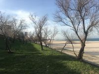
The shoreline has great stability, but it suffers from a continuous but slow withdrawal process, that generates landslides that look like false terraces. Erosion, especially due to socio-economic pressure, affects the complex geological structure of the coastline.
-
 Geomorphology, landscape units and coastal typology
 -
 Coastline evolution
 -
 Coastal perspective


Land use
The main characteristic is intensely urbanized area with a fragmentary use of the land. The city and the port are 2 distinct areas, both from a landscape scenery point of view and also from an administrative one. Recent redistribution of land use patterns (e.g. residential) was possible due to an imbalance of land price, which has resulted in an urban landscape reconfiguration.
-
 Land use

Green/blue infrastructure
Agigea Marine Dunes (south) - biosphere reserve territories (north) corridor is characterized by terraced landscape unit as a topographic facility in connection to the park/s meeting lake/s (Siutghiol and Tăbăcăriei), apart from the Black Sea’s green shoreline. Intense urbanization affects these elements. Moreover, there is huge potential for the reconversion of the former industrial derelict sites.
-
 Green blue infrastructure
 -
 Community zone
 -
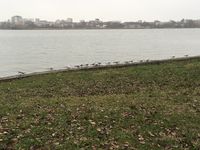 Tăbăcăriei lake
 -
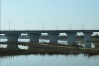 Agigea lake
 -
 Port perspective 1
 -
 Port perspective 2


Actors and stakeholders
Almost the entire coastal area can be accessed and used by the public, so many different users and stakeholders are interested in the coastline. Even if the government and the local municipality regulate the whole studied area, there are other stakeholders with an impact, such as business developers and the Constanța port. Despite not having a strong participatory culture, recent years have brought up an undersized critical mass of activists comprised of NGOs, local initiative groups and professionals working in the planning/environmental sectors, together with journalists bloggers and lobbyists, militating on behalf of the local community.

Power map
Sacred spaces and heritage
Constanța/Kustenge/Kustendje(h)/Tomis is a layered archaeological, architectonic, pluri-ethnic spiritual harbour site abundant in monuments (the Ancient City of Tomis), thus revealing the multicultural identity of the city and its great history, partly affected also by the World Wars attested through the presence of bunkers and documents revealing restoration processes of monuments. The port area is characterized by a vast industrial heritage site with renowned monuments dating from the early twentieth century.
-
 Sacred spaces and heritage
 -
 Casino
 -
 Old town
 -
 Degradation
 -
 Vernacular
 -
 Industrial heritage


Visual appearance and landscape narrative
For the last century, the Romanian coastline inspired tens of famous authors, painters and lately, directors and singers. The Casino along with its promenade, the city’s landmark, was depicted in Cella Serghi’s autobiographic novel ,,Spiderweb” and also, later, by art historian Doina Păuleanu and architect Radu Cornescu; it also appears in many paintings. Besides the valuable cultural heritage layered from various generations and ethnicities, another essential element for the landscape character is the abandoned waterfront.
Authors:
Cella Serghi – Pânza de Păianjen (Spider Web)
Jean Bart – Europolis
Tudor Ganea – Cazemata (The Casemate)
Painters:
Nicolae Vermont, Peisaj marin cu portul Constanța (Marine landscape of the Constanța port); Plajă (Beach) (see image 1)
Marius Bunescu, Înainte de furtună (Before the storm) (see image 2)
Arthur Verona, Violonist în barcă (The violinist on the boat) (see image 3)
Theodor Pallady, Peisaj din Constanța (Constanța’s landscape) (see image 4)
Nicolae Grigorescu, Femeie pe malul mării (The woman on the seashore) (see image 5)
Directors:
Francis Ford Coppola - Youth without Youth
Rian Johnson - The Brothers Bloom
Savel Stiopul – Aventuri la Marea Neagră (Black Sea Adventures); Nea Marin Miliardarul (Marin the billionaire)
Singers:
B.U.G. Mafia - Pe Coastă (On the coast) – (you can listen to the link - https://www.youtube.com/watch?v=7fc9jhvzjSg)
Inna - Spre mare (By sea) – (you can listen to the link - https://www.youtube.com/watch?v=5wqJ1E5cXLw)
Vama veche - Vino să visăm sub apă (Come to dream under water) – (you can listen to the link - https://www.youtube.com/watch?v=oHcWjSH6_a8)
-
 Image 1
 -
 Image 2
 -
 Image 3
 -
 Image 4
 -
 Image 5


A.2 Summary of you landscape system analysis and your development Targets
Chaotic urbanization poses environmental problems in the studied coastal context, so making cities and human settlements inclusive, resilient and sustainable objective is at risk.
We hypothesise that different coastal patterns driven by environmental, historical, cultural and economic discrepancies between northern Constanța and southern Agigea (poor coastal planning) lead to coastal degradation.

DPSIR
-
 Hypothesis

A.3 Theory reflection
- Reflect on at least three international policy documents in relation to their local landscape case
- choose one international, one European and one national document
- You can choose references from our reading list
- Scope: 250 words
A.4 References
1. MONITORING OF COSTAL EROSION, THE MAIN INSTRUMENT IN THE ASSESSMENT OF THE GEOMORPHOLOGICAL STATUS OF THE ROMANIAN COUNTRY - TRADITIONS AND PERSPECTIVES. Available at: http://www.agir.ro/buletine/2431.pdf (accessed on 07/06/2018).
2. The 10 problems of Romanian coastal zone. Available at: https://www.ziuaconstanta.ro/diverse/stiri-calde/ziua-internationala-a-marii-neagre-cele-10-probleme-ale-zonei-costiere-romanesti-612805.html (accessed on 07/06/2018).
3. DEVELOPMENT TERRITORIAL STRATEGY OF ROMANIA. Available at: http://www.fonduri-structurale.ro/Document_Files/Stiri/00017493/7hctm_Anexe.pdf (accessed on 07/06/2018).
4. Ten historic sites to visit the Black Sea. Available at: https://www.historia.ro/sectiune/general/articol/10-obiective-istorice-de-vizitat-la-malul-marii-negre (accessed on 07/06/2018).
5. The official list of historic monuments and heritage sites in Constanța - revision 2015. Available at: https://patrimoniu.gov.ro/images/lmi-2015/LMI-CT.pdf (accessed on 15/04/2018).
6. The Ancient City of Tomis. Available at: https://ro.wikipedia.org/wiki/Ora%C8%99ul_antic_Tomis (accessed on 07/06/2018).
7. The Port of Constanța - official page. Available at: http://www.portofconstantza.com/apmc/portal/static.do?package_id=comunitate&x=load (accessed on 07/06/2018).
8. Constanța magnet-city - World Bank Report on Romanian Magnet-Cities. Available at: https://openknowledge.worldbank.org/handle/10986/27874 (accessed on 10/05/2018), http://www.ct100.ro/video-constanta-oras-magnet-unul-din-cinci-romani-ar-alege-sa-se-mute-aici/ (accessed on 12/05/2018).
10. World Bank Report on Romanian Magnet-Cities - Constanța Municipality/Metropolitan Area Debate 9 Febr. Available at: https://youtu.be/W29d_T5zoak (accessed on 13/05/2018).
11. Constanța magnet-city - perception at local level. Available at: https://www.ct100.ro/banca-mondiala-primaria-constanta-si-alba-ca-zapada/ (accessed on 13/05/2018).
12. CET area. Available at: http://www.radet-constanta.ro/index.php (accessed on 11/06/2018).
13. Local NGOs fighting for transparency and sustainable urban development in Constanța city in relation to public investments in roads rehabilitation. Available at: https://www.ziuaconstanta.ro/stiri/administratie-locala/asociatia-eco-dobrogea-despre-reabilitarea-strazilor-termele-romane-si-traian-vor-fi-taiati-copaci-nu-este-prevazut-tranzitul-velo-trotuarele-657204.html (accessed on 24/04/2018).
14. Public investments in roads rehabilitation in Constanța city. Available at: https://www.ziuaconstanta.ro/stiri/imobiliare/drumul-si-platformele-din-spatele-silozurilor-modernizate-de-cn-apm-sa-constanta-654947.html (accessed on 24/04/2018).
15. Public investments in roads rehabilitation in Constanța city. Available at: https://www.ziuaconstanta.ro/stiri/justitie/incepe-haosul-pentru-soferii-din-constanta-sens-giratoriu-amenajat-ca-insula-circulara-cu-spatiu-verde-si-trotuare-refacute-653440.html (accessed on 24/04/2018).
16. Local debate initiated by the NGO sector for awareness raising on the attractiveness of Constanța city in relation to sustainable urban mobility concepts and inclusive participatory urbanism. Available at: https://expertforum.ro/dezbatere-locala-constanta-atractivitate-mobilitate-si-urbanism-participativ/ (accessed on 05/06/2018).
Phase B: Landscape Evaluation and Assessment
B.1 Assessment Strategy
Overall goal: Identifying and analyzing what are the potential harming features, depending on the character of the zones:
Zone 1 – Community beach - goal: existing open free public space for the community, along the existing promenade;
Zone 2 – Community and tourism beach - goal: free beach public space for the community, as well for tourists who can visit Constanța throughout the year;
Zone 3 – Tourism harbour area – goal: existing open free public space close to historical landmarks;
Zone 4 – Industry and port area – goal: existing unused space properly close to/in the industrial heritage units.
Depending on the context, the elements to be mapped are potential elements, the supporting elements and the problematic elements.
B.2 Mapping
-
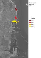 Assessment mapping
 -
 Subzone 1 - DISRUPTIVE over HARMONIOUS
 -
 Subzone 2 - VARIETY in transition
 -
 Subzone 3 - FORGOTTEN heritage
 -
 Subzone 4 - ABUSIVE port


B.3 Problem definition and priority setting
The four subzones have different characteristics, so different problem/potentials elements have been identified.
In the first subzone, several land reserves for the community were identified, so that these elements highlight the potential element, the existing promenade, but discontinuous. The priority lies in the identification and improvement of some walkways that can provide links with free open space planning for this subzone.
In the second subzone, the potential element is a hillock (Neagoe's hat) on Modern Beach. In a context where this beach is divided into several private beaches, this free public landmark becomes a priority in the process of creating an identity, a transition between community and tourism areas.
The third subzone is the main attraction of tourists and residents of Constanța. Here, open free public areas are almost non-existent (loss of open free space), so this area can be highlighted by organizing different events (as it has just begun to happen lately). However, there is a potential place in the Casino area, namely the existence of a very small beach that attracts many visitors.
The fourth subzone has the potential to be the city's inhabitants, the visitors and the port connector. Here the priority lies in the opening of the industrial heritage to everybody, but also the functional reconversion of it.
B.4 Theory reflection
- Please reflect the assessment and evaluation methods used based on at least three readings
- Did you encounter limitations'
- 200 words test contribution
B.5 References
- give a full list of the references you have used for this section
Phase C – Strategy and Master Plan
C.1 Goal Setting
Subzone 1 – DISRUPTIVE over HARMONIOUS Strategy 1 - Optimizing open public space by implementing eco-urban installations to promote a community environment for people of all ages.
Goal 1.1 – Create a community urban local scene which is accessible and inclusive to all residents;
Goal 1.2 - Use recyclable materials and engage nearby school students and the community in building the urban installations.
Subzone 2 – VARIETY in TRANSITION Strategy 2 – Transforming the hillock into a complex, terrestrial and floating landmark, to promote the diversity of the zone.
Goal 2.1 – Systematize existing hillock land to make it accessible and create a larger scale coastal scene;
Goal 2.2 - Extend the scene through a height change so as to create a circular promenade on the sea.
Subzone 3 – FORGOTTEN heritage Strategy 3 - Capturing urban perspectives to highlight the varied historical heritage.
Goal 3 - Place tall urban installations of different shapes to offer interesting panoramas on historical heritage as well as on the port.
Zone 4 – ABUSIVE port Strategy 4 - Outreach excellence. Foster strategic partnerships, which enhance maritime services and research.
Goal 4.1 - Develop strategic partnerships with public, students and academic researchers in the Constanța University area that increases maritime research and awareness of the industrial port heritage;
Goal 4.2 – Create the marine science port platform, including the functional reconverted industrial heritage.
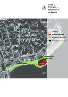
C.2 Spatial Strategy and Transect
Four identities, one coastline
The coastline of Constanța is a continuous one, from all points of view. This is supported by an organic promenade linking the four areas of the city. Parts of the promenade are linear (the old portions), straight, connected to the urban blue / green infrastructure. In each zone, we find urban installations that strengthen its character.
The first area features a coastal urban landscape in a HARMONIOUS relationship with the community. Here, residents can ,,play an important role’’ on the mini-scenes located along the promenade.
The transition between the community and the tourist area is supported by the coastal scene on the beach of the second zone. Here users find a VARIETY of activities.
The landmark of Constanta, the Casino, was joined by a series of simple and tall urban installations located on the beach. This area is the main attraction, offering panoramic views of the REMEMBERED coastal historic heritage.
The science port is the magnet of the city. In this platform, all city actors can collaborate in a COMPLEMENTARY way. The old industrial halls are now a source of development and innovation of the coastal urban area.
-
 Vision
 -
 Transect
 -
 Subzone 1 - Community scene
 -
 Subzone 2 - Coastal scene
 -
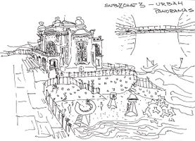 Subzone 3 - Urban panoramas
 -
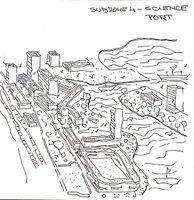 Subzone 4 - Science port


C.3 From Theory of Change to Implementation
Good governance of coastal areas requires a balance between economic growth and sustainability, therefore it takes a multi-stakeholder approach, in which competing interests are accounted for in a transparent manner. Specifically, good governance requires consideration of private-sector interests alongside environmental and social concerns in order to be successful. A conducive business environment is essential to attract investments, create jobs and support economic development. However, such efforts must be balanced against public concerns and environmental protection, which is what makes good governance in this area complex.
For the planning process we are going to use the tool of Maritime Spatial Planning, which supports and facilitates the implementation of the Europe 2020 Strategy for smart, sustainable and inclusive growth, which aims to deliver high levels of employment, productivity and social cohesion, including promotion of a more competitive, resource-efficient and green economy. The coastal and maritime sectors have significant potential for sustainable growth.
-
 Governance model
 -
 Governance process


C.4 References
1. DIRECTIVE 2014/89/EU OF THE EUROPEAN PARLIAMENT AND OF THE COUNCIL. Establishing a framework for maritime spatial planning. Available at: https://eur-lex.europa.eu/legal-content/EN/TXT/?uri=celex%3A32014L0089 (accessed on 14/06/2018);
2. Examining the Ocean and Coastal Governance Framework in Trinidad and Tobago. Transitioning Towards Integrated Coastal Zone Management. Available at: http://www.un.org/depts/los/nippon/unnff_programme_home/fellows_pages/fellows_papers/Hassanali_1314_T&T.pdf (accessed on 14/06/2018);
3. Coastal Governance Index 2015. Available at: https://www.oceanprosperityroadmap.org/wp-content/uploads/2015/05/EIU_CGIndex_WEB-revised-June-4.pdf (accessed on 14/06/2018);
4. Developing an effective governance operating model. A guide for financial services boards and management teams. Available at: https://www2.deloitte.com/content/dam/Deloitte/global/Documents/Financial-Services/dttl-fsi-US-FSI-Developinganeffectivegovernance-031913.pdf (accessed on 14/06/2018);
5. Maritime spatial planning. Available at: https://ec.europa.eu/maritimeaffairs/policy/maritime_spatial_planning_en (accessed on 14/06/2018).
D. Process Reflection
Constanța team members are coming from three different backgrounds: urbanism, sociology and horticulture. Three of the team members are involved in a master’s degree of Regional Development and Territorial Planning, another student is activating in Constanța formally as a public officer. For us, it was more of a challenge to work in a virtual environment. This way of working requires several skills which are hard to gain in the classical environment of studying. Time constraints were a problem to be overcome, as each of us was facing several projects to be attended at the same time. It was helpful for the students coming from a different background than urbanism to learn how to draw landscape planning schemes. Also, it was really handy to be involved in the project as it was reflecting the outcomes of the master in which we are involved. In that way, we were able to apply in a more realistic way what we have learned during the last year. Also, we had the chance to learn new and exciting things about Constanța and the Romanian coast.
If we’re to start this project again, we would like to organise ourselves better and meet more often. As a conclusion, we realised that CO-LAND helped us to have a realistic approach towards coastal landscape planning, Constanța being an economic and cultural strategic point on a global scale.