Case Study D: Baia: Difference between revisions
Amrita.ali (talk | contribs) |
|||
| (70 intermediate revisions by 6 users not shown) | |||
| Line 9: | Line 9: | ||
{| align="right" width="400pt" style="background:Gainsboro; color:black" | {| align="right" width="400pt" style="background:Gainsboro; color:black" | ||
|- | |- | ||
| '''Area''' ||style="background:Lavender"| '' | | '''Area''' ||style="background:Lavender"| ''Workgroup Naples D: Baia'' | ||
|- | |- | ||
| '''Place''' || style="background:Lavender"|'' | | '''Place''' || style="background:Lavender"|''Naples'' | ||
|- | |- | ||
| '''Country''' || style="background:Lavender"|'' | | '''Country''' || style="background:Lavender"|''Italy'' | ||
|- | |- | ||
| '''Topics''' || style="background:Lavender"|'' | | '''Topics''' || style="background:Lavender"|''Rationale, Coastal Typology, Land use development, Green and Blue Infrastructure, Power map, Sacred Spaces and Heritage, Landscape Narrative'' | ||
|- | |- | ||
| '''Author(s)''' || style="background:Lavender"|'' | | '''Author(s)''' || style="background:Lavender"|''Panaitescu A., Lungu D., Cairo M., Aquino L., Jayalath S., Miraldi A., Passaro A., Ali A.'' | ||
|- | |- | ||
| colspan="3" align="center" style="background:silver"| [[File: | | colspan="3" align="center" style="background:silver"| [[File:Baia Maps Limit.png|400px]] | ||
|- | |- | ||
| ||style="background:Lavender"| | | ||style="background:Lavender"| | ||
| Line 27: | Line 27: | ||
= Rationale = | = Rationale = | ||
Underwater Heritage: History and nature are merged in both, earth and sea. | |||
However, Baia¿s interest is focused on tourism, not fully in the preservation of the site. | |||
If this continues, with only investment on the tourism infrastructure without and Investment of Landscape Preservation+Heritage Conservation Baia’s days might be in a countdown already. | |||
= Location and scope = | = Location and scope = | ||
''You can edit this map with the [[Special:MapEditor|map editor]]'' | ''You can edit this map with the [[Special:MapEditor|map editor]]'' | ||
{{#display_map: | {{#display_map: 40.8166634,14.068499726~Baia~Location of our Intensive Study Programme | ||
}} | }} | ||
| Line 40: | Line 42: | ||
== A.1 Landscape layers and their system context == | == A.1 Landscape layers and their system context == | ||
=== Geomorphology, landscape units and coastal typology === | === Geomorphology, landscape units and coastal typology === | ||
*''Coast of Baia, is a dramatic landscape in terms of forces of nature, throughout the history. Seldom volcanic activities and frequent waves of the ocean (basically) have been shaped the coast today with a unique composition of relatively young and old physical matter. (Figure 1) . Due to immediate high ground associate with the coast of Baia defined by the waves of land, ‘coastal effect’ have been limited to a narrow ‘landstrip’ relative to a typical coast. And with the act of the rich humid wind, greenery have been covered the facade of those elevated landforms. And these walls are a combination of Caldera rims and Major,Minor Faults. So the drama will continue as | *''Coast of Baia, is a dramatic landscape in terms of forces of nature, throughout the history. Seldom volcanic activities and frequent waves of the ocean (basically) have been shaped the coast today with a unique composition of relatively young and old physical matter. (Figure 1) . Due to immediate high ground associate with the coast of Baia defined by the waves of land, ‘coastal effect’ have been limited to a narrow ‘landstrip’ relative to a typical coast. And with the act of the rich humid wind, greenery have been covered the facade of those elevated landforms. And these walls are a combination of Caldera rims and Major,Minor Faults. So the drama will continue as above geomorphological terms describes themselves. | ||
'' | '' | ||
*''add 1-2 graphical representations to the image gallery, you can add more if you like'' | *''add 1-2 graphical representations to the image gallery, you can add more if you like'' | ||
<gallery caption=" " widths="200px" heights="150px" perrow="5"> | <gallery caption=" " widths="200px" heights="150px" perrow="5"> | ||
File:yourcase_landscapeunits1.jpg|'' | File:yourcase_landscapeunits1.jpg|''Geomorphological Character_Reference: Aucelli, P., et al., Coastal landscape evolution of Naples (Southern Italy) since the Roman period from archaeological and geomorphological data at Palazzo degli Spiriti site, Quaternary International (2017), https://doi.org/10.1016/ j.quaint.2017.12.040'' | ||
File:yourcase_landscapeunits2.jpg|''add a caption'' | File:yourcase_landscapeunits2.jpg|''add a caption'' | ||
</gallery> | </gallery> | ||
| Line 72: | Line 74: | ||
=== Actors and stakeholders === | === Actors and stakeholders === | ||
* ''Who is driving changes in this landscape? Who is affected by those changes? | * ''Who is driving changes in this landscape? Who is affected by those changes? | ||
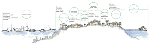
Baia is under control of different administrative sectors in different phases, for example decisions made by Campania region, province Napoli or Bacoli municipality has major or minor action on Baia and it’s locality. Both the Tourists and the inhabitants simultaneously affects and get affected by any change in policy. Uneven empowering of one sector may affect positively or negatively the future of this unique heritage site. UNESCO and UN Habitats may play a vital role in bringing balanced solution. Ministry of cultural Heritage and Archaeology department have power to let people know about the history and morphology of the site and how to protect it. | |||
<gallery caption=" " widths="500px" heights="200px" perrow="5"> | |||
File:Adminstry of Baia case study template.png|''Administrative position and different power holders in different phases responsible for acts and implementation in Baia and adjacent area.''|300px|left| | |||
File:Power plan Baia case study template.png|''Plan showing the section line of the two areas of Baia. The image is taken from the Google satellite image.'' | |||
File:AA' section case study template.png|''Cross section of Baia port and closest tourism area, analyzing different actors and stakeholders in site'' | |||
File:BB' section case study template.png|''Cross section through Baia port and adjacent archaeological sites showing different actors and stakeholders relationship'' | |||
</gallery> | |||
* ''Draw a stakeholder and/or power map: Who is affected highly but with low power? Who has high power but is not affected?'' | * ''Draw a stakeholder and/or power map: Who is affected highly but with low power? Who has high power but is not affected?'' | ||
<gallery caption=" " widths="500px" heights="200px" perrow="5"> | <gallery caption=" " widths="500px" heights="200px" perrow="5"> | ||
File: | File:Power loop Baia case study template.png|''Different people in different phase is affecting each other by their power of making a decision. So the whole scenario is acting like a power loop.'' | ||
File:Power Pyramid Baia case study template.png|''A Pyramid showing the power distribution in terms of size and power variation. For example, the Tourists and inhabitants are the greater populations by size by lies on the bottom of the Power level.'' | |||
</gallery> | </gallery> | ||
=== Sacred spaces and heritage === | === Sacred spaces and heritage === | ||
*''Which places/elements hold cultural value and to whom?'' | *''Which places/elements hold cultural value and to whom?'' | ||
The territory of Bacoli was founded by the ancient Romans and it is an environmental landscape of exceptional historical value, today the remains of the cisterns of ''Cento Camerelle'', the ''Grotta of Dragonar''a and the cistern of ''Piscina Mirabilis'', which constitute the terminal tank of one of the main Roman aqueducts. | |||
Another important historical heritage is the ''Archaeological Park of Baia'', organized on terraces called ''Terme of Baia'' (''Fig.1''). The complex is presented as a series of residences consisting of separate architectural nucleus, organized on different levels of terracing and connected by stepped ramps. | |||
Lying towards the sea is the "''Villa dell'ambulatio''" equipped with a series of terraces connected by a complex of stairs, the last of which leads to the "''Mercury sector''". The "''Temple of Sosandra''" is bordered by two parallel staircases. The entire complex originally had marble or black and white mosaic floors. | |||
The lowering of the ground below sea level, due to bradyseism, occurred between the 7th and 8th centuries AD, submerged Baia (''Fig.2''). Among the most significant remains are some vaulted structures like the great ''Temple of Diana'', the ''Temple of Mercury'' and ''Temple of Venus'', it is in any case thermal structures and not places of worship, for which however the popular denomination has survived. | |||
The ''Temple of Diana'' which originally defined a large room where vapors from the ground below were collected, was characterized by a colossal ogival dome, now half collapsed. The building was used for thermal purposes and was decorated with marble friezes depicting hunting scenes. | |||
The ''Temple of Venus'' rises on the quay of the port of Baia, dated to the Hadrian age. The plant is circular on the inside and octagonal on the outside. It is believed that the monument was part of the thermal plant although today it is no longer possible to grasp this identity because of the modern road. It can be visited simply by locating it among the houses and approaching it. | |||
The ''Temple of Mercury'' Also called "truglio" from its circular shape, the building was a frigidarium that is used for cold baths. From the descriptions made of it in the eighteenth century it appeared to be composed of six niches, four of which are semi-circular. The circular vault, equipped with a central lumen, was made with large flakes of tuff shaped like a wedge. | |||
The ''Aragonese Castle'' (''Fig.3'') rises in Baia, a hamlet of Bacoli, and is situated in an area of considerable strategic importance, it was erected on a 51 m promontory naturally defended by a high tuff cliff and by the deep depression given by the caldera of two called volcanoes " Fondi di Baia "with the addition of walls, ditches and drawbridges, the castle was practically impregnable. Its position allowed a very wide control of the area, preventing so much the approach of enemy fleets. | |||
Due to its central position relative to the main archaeological sites of the Phlegraean Fields the castle of Baia was chosen as the site of the Archaeological Museum of the Phlegraean Fields. | |||
Along the coast, there are religious monuments such as the Church of San Sossio, the Church of S. Maria del Riposo, the Church of S. Anna Gesù and Maria and the Church of San Gioacchino. | |||
The particularity of the territorial morphology and the phenomenon of bradyseism make the area very interesting for tourists. | |||
* ''You may add a map and some images, please also explain in your caption why these elements are valuable'' | * ''You may add a map and some images, please also explain in your caption why these elements are valuable'' | ||
<gallery caption=" " widths="200px" heights="150px" perrow="5"> | <gallery caption=" " widths="200px" heights="150px" perrow="5"> | ||
File:your case_sacredspace1.jpg|'' | File:your case_sacredspace1.jpg|''Fig.1 ''Terme of Baia'' | ||
File:your case_sacredspace2.jpg|'' | File:your case_sacredspace2.jpg|''Fig.2 ''Submerged Archaeological park of Baia'' | ||
File:your case_sacredspace3.jpg|'' | File:your case_sacredspace3.jpg|''Fig.3 ''Aragonese Castle'' | ||
</gallery> | </gallery> | ||
=== Visual appearance and landscape narrative === | === Visual appearance and landscape narrative === | ||
*''Which elements are essential for the landscape character?'' | *''Which elements are essential for the landscape character?'' | ||
The landscape is defined by two elements: The Archeological Park and The Aragonese Castle of Baia. The first-mentioned element includes the "Terme di Baia", an antique ensemble which functioned as a thermal resort. Due to its vicinity to Naples, a great urban attractor, Baia has been a secondary center of interest in the area. However, throughout history, it has gone from a small village to a fashionable thermal resort in Antic Roman Republic. Between 100 BC and 500 AD it was well-known for its hedonistic atmosphere and it was better-preferred over area as Pompeii, Capri or Herculaneum. | |||
Aside from its historical and architectural value, The Castle of Baia enriches the landscape by its position - on an upper side of the land - highlighting the natural surroundings." | |||
*''Has the landscape been painted or otherwise depicted, when and whom? Which elements are essential?'' | *''Has the landscape been painted or otherwise depicted, when and whom? Which elements are essential?'' | ||
In painting, Baia is related to the greek and roman mythology. An often pictured subject is the meeting of Apollo and Cumaean Sibyl near the bay of Baia. Cumaen Sibyl is the best known of the 10 sibyls – a “sibyl” is a prophetess, most of the times associated with a particular location. Even though she lived in a cave near the town of Cumae, close to the temple of Apollo, both of them are pictured near the bay of Baia. | |||
Two painters who have approached this subject are Claude Lorraine - a baroque painter - and William Turner in his romantic manner. Each of them, in their own way, chose to paint the mythological story behind Baia. In the case of Turner, mythology itself is a common theme of Romanticism. | |||
The Phlegraean (which includes Baia) area was a key subject for local and foreign painters since the 19th century. The italian painter, Giacinto Gigante has made many paintings inspired by the beautiful landscape of Baia. | |||
*''Which narratives exist? Who has written about this landscape or depicted it in some way?'' | *''Which narratives exist? Who has written about this landscape or depicted it in some way?'' | ||
'''The lost wonders of Baia were a common feature of Romantic poetry.''' It appears in John Keats's '''"Ode to May"''' and in the third stanza of Shelley's '''"Ode to the West Wind"'''. The vanished columns of the ancient town inundated by the sea is the central conceit of Konstantin Batyushkov's 1819 '''"You awake, oh Bayya, from the tomb..."''', "one of his last and finest poems". | |||
The "princely" seaside resort of the empire appears in J. Meade Falkner's 1895 novel '''The Lost Stradivarius and Anatole France's''' 1902 '''"Procurator of Judea" (Le Procurateur de Judée)'''. In current fiction, it is the setting of '''Caroline Lawrence's Sirens of Surrentum'''; '''John Maddox Roberts's Under the Shadow of Vesuvius'''; '''Steven Saylor's 1992 Arms of Nemesis''', set during the Spartacus Rebellion; and '''Marguerite Yourcenar's Memoirs of Hadrian'''. | |||
In the '''Ecce Romani series of Latin textbooks''', Baia is the location of the character Gaius Cornelius Calvus's summer villa. | |||
A forgotten Baia tunnel complex features prominently in the '''UK series called Forbidden History''', whereby the presenter visits a supposed grotto of the Cumaean Sibyl. | |||
Beside the cultural references, there are '''many tales of intrigue''' associated with Baia. Rumour has it that Cleopatra escaped in her boat from Baia after Julius Caesar was murdered in 44BC, while Julia Agrippina plotted her husband Claudius’ death at Baia so her son Nero could become emperor of Rome. | |||
Mineral waters and a mild climate first attracted Rome’s nobility to Baia in the latter half of the 2nd Century BC, and the town was known to them as the Phlegraean (or ‘flaming’) Fields, so named because of the calderas that pockmark the region. | |||
<gallery caption=" " widths="200px" heights="150px" perrow="5"> | <gallery caption=" " widths="200px" heights="150px" perrow="5"> | ||
File: | File:Maps Parco archeologico.png|''Satellite view of the Archeological Park in Baia (source: Google Maps)'' | ||
File: | File:William Turner.jpg|''"The Bay of Baiae, with Apollo and the Sibyl", William Turner, 1823 (source: Tate Modern)'' | ||
File: | File:Anton Sminck Pitloo - Bacoli.jpg|''Baia Coast is well known residential area since the Roman Empire and inspired foreign painters as well.Painting by Anton Sminck Pitloo (source:https://ro.pinterest.com)'' | ||
File:Mdo-3039389.jpg|''Baia, 1850 by Giacinto Gigante (source: https://www.agefotostock.com)'' | |||
</gallery> | </gallery> | ||
== A.2 Summary of you landscape system analysis and your development Targets == | == A.2 Summary of you landscape system analysis and your development Targets == | ||
<gallery caption=" " widths="500px" heights="200px" perrow="5"> | <gallery caption=" " widths="500px" heights="200px" perrow="5"> | ||
File: | File:Baia System Analysis.jpg|''DPSIR Analysis of Baia: Two main elements are treatening the future situation of Baia. The always growing flotant population due to an increase of tourism and a Waste Managment Crisis that has been taking place since the early 2000´s. This pressures are attempting to have a negative impact not only in the green landscape but also in the blue infrastructure of the City, which is directly connect to the Cultural Heritage of Baia. '' | ||
</gallery> | </gallery> | ||
<gallery caption=" " widths="500px" heights="200px" perrow="5"> | <gallery caption=" " widths="500px" heights="200px" perrow="5"> | ||
File: | File:Baia Hypothesis.jpg|''Our hypothesis is a scenario with an overpopulation of tourists and a pooor managment of the waste produced by them. This situation will in high speed deteriorate the landscape and the heritage of Baia'' | ||
</gallery> | </gallery> | ||
| Line 123: | Line 176: | ||
== A.4 References == | == A.4 References == | ||
* ''give a full list of the references you have used for this section'' | * ''give a full list of the references you have used for this section'' | ||
'''Visual appearance and landscape narrative''' | |||
- https://en.wikipedia.org/wiki/Baiae#History | |||
- https://en.wikipedia.org/wiki/Cumaean_Sibyl#The_caves_at_Cumae_and_Baiae | |||
- http://act.unilink.it/baia-parco-archeologico-delle-terme-napoli/ | |||
- https://www.falsi-d-autore.it/marina-c-5426_5445/baia-di-napoli-p-1918.html | |||
- https://www.smithsonianmag.com/history/the-unsolved-mystery-of-the-tunnels-at-baiae-56267963/ | |||
- https://napoli.repubblica.it/cronaca/2018/07/12/news/weekend_alle_terme_romane_di_baia_per_il_pozzuoli_faber_jazz_festival-201611726/?refresh_ce | |||
- https://journals.openedition.org/mefra/300?lang=es | |||
- http://www.freebacoli.net/2018/06/pozzuoli-faber-jazz-festival-i-concerti-itineranti-faranno-tappa-anche-a-baia-e-cuma/ | |||
= Phase B: Landscape Evaluation and Assessment = | = Phase B: Landscape Evaluation and Assessment = | ||
== B.1 Assessment Strategy == | == B.1 Assessment Strategy == | ||
*'' | *''GOALS: | ||
Identifying the elements which have a double value – are both risks and potentials.Collecting data and processing it into relevant information. Therefor our mapped themes are archeological sites and natural protected areas'' | |||
<gallery caption=" " widths="600px" heights="300px" perrow="5"> | |||
File:AssesmentStrategy.JPG| | |||
</gallery> | |||
== B.2 Mapping == | == B.2 Mapping == | ||
| Line 134: | Line 208: | ||
*''As a minimum, at least three different themes need to be mapped, you may choose more if needed'' | *''As a minimum, at least three different themes need to be mapped, you may choose more if needed'' | ||
<gallery caption=" " widths=" | <gallery caption=" " widths="600px" heights="300px" perrow="1"> | ||
File: | File:Mobility and connection mapping of Baia city case study.jpg|'' This map illustrates the Existing transportation route and mobility analysis. The yellow lines demonstrate the 'Narrow roads inside the city' and they mainly provide access to the residences, shops, no pedestrians or defined bicycle path, have poor road condition, hardly accommodates two cars, one bike and one car can do). The orange route shows"Bigger Roads within the city"(They are spacious enough for cars and buses, but some of them lack footpaths, have adequate surface parking in various pauses). The Redline is to show the route of 'Inter-city connecting highway'(It has access to plenty of bus and cars, the main public transport route, adequate pedestrians, direct link with the beach and exciting view of the sea). The only walkable area along the coastline is adjacent to this highway marked with a light green patch. The dark brown dotted line illustrates 'Only Rail route' or Transit. It has exciting underpass for a long way, no stoppage close to the coast, not enough facility to serve inside the city and coastal zone for the tourist)'' | ||
File: | File:Slow and fast traffic.JPG|'' Google Traffic map shows which area has the faster traffic and which area deals generally with the slower traffic inside the city of Baia'' | ||
File: | File:Findings conclusions from mobility maps n sections.png|'' To improve the greenness of a city there is no alternative of public transport, Bi-cycle route to encourage cycling and wide pedestrians to improve the walkability all through the city may bring a charming change to this valuable historic site. Every individual household can contribute to making a green city by planting in front of their houses and by reducing the greyness of the city. The agricultural fields can be opened to the passers-by which will make the walking experience even more eye-soothing and pleasing for the tourists.'' | ||
</gallery> | </gallery> | ||
== B.3 Problem definition and priority setting == | == B.3 Problem definition and priority setting == | ||
* ''Give a summary of the major findings of your mapping process, what are the problems/potentials identified?'' | * ''Give a summary of the major findings of your mapping process, what are the problems/potentials identified?'' | ||
Our major priorities and targets regarding Baia area aim to '''protect and rehabilitate the Natural Protected Areas Polygon''', but also '''to enhance the mobility and walkability within the city for tourtists and local''' adding green solutions. | |||
<gallery caption=" " widths="500px" heights="200px" perrow="5"> | <gallery caption=" " widths="500px" heights="200px" perrow="5"> | ||
File: | File:Baia subaquea.gif|''Accessibility to the archeological sites'' | ||
File:Ancient-Roman-seawater-concrete-harbor-sites-central-Italian-coast-with-Al-tobermorite (1).png|''Ancient Roman seawater concrete harbor sites, central Italian coast, with Al-tobermorite in relict lime clasts, mid-first century BCE to first century CE. '' | |||
</gallery> | </gallery> | ||
| Line 155: | Line 232: | ||
== B.5 References == | == B.5 References == | ||
- Google maps and Google street view of Baia city, Italy; Copyright@2019 | |||
- Section and perspective drawing by Amrita U., A., A. | |||
- https://www.researchgate.net | |||
- http://itinerari.baiadinapoli.it | |||
=Phase C – Strategy and Master Plan = | =Phase C – Strategy and Master Plan = | ||
== C.1 Goal Setting == | == C.1 Goal Setting == | ||
*'' | *'' Through ages, walking under the coast'' | ||
To reduce energy consumption, To make a balance in facilitating locals and tourists, To ensure better mobility, To encourage walkability and cycling, to take it to forward to a more green city, To connect the scattered heritage sites into a tourism channel | |||
'' | |||
*''Link back to your original targets from section one and the [http://www.un.org/sustainabledevelopment/sustainable-development-goals/Sustainable Development Goals]'' | *''Link back to your original targets from section one and the [http://www.un.org/sustainabledevelopment/sustainable-development-goals/Sustainable Development Goals]'' | ||
* ''150 words text contribution'' | * ''150 words text contribution'' | ||
| Line 168: | Line 253: | ||
*''exemplify your vision in the form of a transect with concrete interventions'' | *''exemplify your vision in the form of a transect with concrete interventions'' | ||
*''add map(s) and visualizations'' | *''add map(s) and visualizations'' | ||
Based on the heritage-centered strategy, the main touristic and archeological attractions on Baia should be linked. In our attention was also reducing the energy consumption of car mobility in Baia and outside it, with nearby cities and villages. | |||
One of the proposed interventions is creating a pedestrian friendly route between Vanvitelliano Park and Baia Archeological Park, which would be enlivened by three new public spaces. Quality outdoor spaces are vital for rising the attractiveness of Baia for both tourists and inhabitants. This kind of interventions should also have a positive impact on the environment, encouraging pedestrian movement and reducing the use of motorized means of transport. | |||
<gallery caption=" " widths="500px" heights="200px" perrow="1"> | <gallery caption=" " widths="500px" heights="200px" perrow="1"> | ||
File: | File:Harta baza traseu.jpg|''Urban acupuncture-based approach for Baia'' | ||
File: | File:Urb ac 1.png|''Public space intervention for 1st area'' | ||
File: | File:Urb ac 2.png|''Public space intervention for 2nd area'' | ||
File:Urb ac 3.png|''Public space intervention for 3rd area'' | |||
File:Timeline baia-wiki.jpg|''This timeline basically shows the chronological study on Baia city and most effective historic events that made Baia a noteworthy area'' | |||
File:Master Plan-wiki.jpg|''Master plan showing a preliminary sketchy module of route planning and the pedestrian route accessible for tourist and local which will reduce the pressure of traffic on the residential alleys and make the visit for the tourist cost effective walkable and easily movable and more enjoyable. several car parking should be ensured on the face of the pedestrian route and some pauses and functions like plantation, benches and a watchtower on the peak level may ensure tourists interest to take the route. It's close proximity to the historical places in the city will be the principal reason for constructing it.'' | |||
File:Visualization of pedestrian route with raw sketches.png|''Some raw sketches to show how things will make differences and bring activity to the pedestrian route with pauses of sittings or watchtower on the peak may add in the experience of the visitors.'' | |||
File:your case_transect_detail2.jpg|''add caption here'' | File:your case_transect_detail2.jpg|''add caption here'' | ||
</gallery> | </gallery> | ||
== C.3 From Theory of Change to Implementation == | == C.3 From Theory of Change to Implementation == | ||
*'' | *''Both the archaeology department and the Baia municipality together should work on to implement them?'' | ||
*'' | *'' Business people should realise the importance and emergence and the huge potential of heritage tourism for Baia, and they should stop random construction within this historical area. Local governance can encourage the people of the city to be more open with their green areas, and make the wine yards welcoming to the visitors so that the existing green infrastructure contribute in the tourism sector and growing economy through the local agriculture'' | ||
*'' | *'' Heritage should be protected and nature should be honoured and considered at any cost, both tourists and locals life should be balanced in the future plan of tourism for Baia city'' | ||
*'' | *''Overall a mass awareness about the value the area and active sensitivity to protect it can be the best solution to all the current problems. Areas like should no more be focusing on industrialization or random construction, rather futuristic prudent approach to save the precious history can serve both the local and the guests of the city. To cope with the global climatic changes there is no alternate of emphasizing on existing green and blue infrastructure along with spreading awareness among people from all sectors. | ||
'' | |||
<gallery caption=" " widths=" | <gallery caption=" " widths="600px" heights="300px" perrow="1"> | ||
File: | File:Vision- and partner.png |''a collaboration of blue and green infrastructure to make the plan implemented'' | ||
File: | File:Visualization-wiki.jpg|''A visualization of the pedestrian area of the master plan, with cycle route, walking trail, watching tower pause.'' | ||
</gallery> | </gallery> | ||
== C.4 References == | == C.4 References == | ||
* ''give a full list of the references you have used for this section'' | * ''give a full list of the references you have used for this section'' | ||
'''Visual appearance and landscape narrative''' | |||
- https://en.wikipedia.org/wiki/Cumaean_Sibyl?fbclid=IwAR1A5DrvtzWfXmrBqMrhvcKn5bqdB0y-ydmR4cRLM9Bixl2nqCNKT51kpUE#The_caves_at_Cumae_and_Baiae | |||
- https://www.smithsonianmag.com/history/the-unsolved-mystery-of-the-tunnels-at-baiae-56267963/ | |||
- https://napoli.repubblica.it/cronaca/2018/07/12/news/weekend_alle_terme_romane_di_baia_per_il_pozzuoli_faber_jazz_festival-201611726/?refresh_ce | |||
- https://journals.openedition.org/mefra/300?lang=es | |||
- http://www.freebacoli.net/2018/06/pozzuoli-faber-jazz-festival-i-concerti-itineranti-faranno-tappa-anche-a-baia-e-cuma/ | |||
- https://en.wikipedia.org/wiki/Baiae | |||
- https://www.mutualart.com | |||
= D. Process Reflection = | = D. Process Reflection = | ||
*''Reflect in your intercultural and interdisciplinary team on the outcomes of your study'' | *''Reflect in your intercultural and interdisciplinary team on the outcomes of your study'' | ||
*'' | *''Mostly the communication gap in different time zones. Also the lack of enough land use map in detail, the language barrier.'' | ||
*'' | *''to manage things from afar and to work by taking responsibility when no one will be responding following own paths?'' | ||
*'' | *''Each week we should fix a mandatory meeting online within a group which will be reported, otherwise, it's hard to gather scattered information about the group and each member's working progress?'' | ||
*''You can also use diagrams/visuals'' | *''You can also use diagrams/visuals'' | ||
*''250 words text'' | *''250 words text'' | ||
Latest revision as of 17:48, 10 June 2019
>>>back to working groups overview
| Area | Workgroup Naples D: Baia | |
| Place | Naples | |
| Country | Italy | |
| Topics | Rationale, Coastal Typology, Land use development, Green and Blue Infrastructure, Power map, Sacred Spaces and Heritage, Landscape Narrative | |
| Author(s) | Panaitescu A., Lungu D., Cairo M., Aquino L., Jayalath S., Miraldi A., Passaro A., Ali A. | |

| ||
Rationale
Underwater Heritage: History and nature are merged in both, earth and sea. However, Baia¿s interest is focused on tourism, not fully in the preservation of the site. If this continues, with only investment on the tourism infrastructure without and Investment of Landscape Preservation+Heritage Conservation Baia’s days might be in a countdown already.
Location and scope
You can edit this map with the map editor
A Landscape System Analysis
A.1 Landscape layers and their system context
Geomorphology, landscape units and coastal typology
- Coast of Baia, is a dramatic landscape in terms of forces of nature, throughout the history. Seldom volcanic activities and frequent waves of the ocean (basically) have been shaped the coast today with a unique composition of relatively young and old physical matter. (Figure 1) . Due to immediate high ground associate with the coast of Baia defined by the waves of land, ‘coastal effect’ have been limited to a narrow ‘landstrip’ relative to a typical coast. And with the act of the rich humid wind, greenery have been covered the facade of those elevated landforms. And these walls are a combination of Caldera rims and Major,Minor Faults. So the drama will continue as above geomorphological terms describes themselves.
- add 1-2 graphical representations to the image gallery, you can add more if you like
-
Geomorphological Character_Reference: Aucelli, P., et al., Coastal landscape evolution of Naples (Southern Italy) since the Roman period from archaeological and geomorphological data at Palazzo degli Spiriti site, Quaternary International (2017), https://doi.org/10.1016/ j.quaint.2017.12.040
-
add a caption
Land use
- settlements, infrastructure, agriculture, resource extraction, natural areas, energy production...
- description of evolution, status quo and driving forces, is the land use likely to change? Why is that? (approx 200 signs)
- add 1-2 graphical representations to the image gallery, you can add more if you like
-
add a caption
-
add a caption
-
add a caption
Green/blue infrastructure
- What are the major potential elements of a green/blue infrastructure network? Are these likely to change/disappear? Why is that?
- You find my background material on green infrastructure in our reading list
- add 1-2 graphical representations to the image gallery, you can add more if you like
-
add a caption
-
add a caption
Actors and stakeholders
- Who is driving changes in this landscape? Who is affected by those changes?
Baia is under control of different administrative sectors in different phases, for example decisions made by Campania region, province Napoli or Bacoli municipality has major or minor action on Baia and it’s locality. Both the Tourists and the inhabitants simultaneously affects and get affected by any change in policy. Uneven empowering of one sector may affect positively or negatively the future of this unique heritage site. UNESCO and UN Habitats may play a vital role in bringing balanced solution. Ministry of cultural Heritage and Archaeology department have power to let people know about the history and morphology of the site and how to protect it.
-

-
 Plan showing the section line of the two areas of Baia. The image is taken from the Google satellite image.
 -
 Cross section of Baia port and closest tourism area, analyzing different actors and stakeholders in site
 -
 Cross section through Baia port and adjacent archaeological sites showing different actors and stakeholders relationship


- Draw a stakeholder and/or power map: Who is affected highly but with low power? Who has high power but is not affected?
-
 Different people in different phase is affecting each other by their power of making a decision. So the whole scenario is acting like a power loop.
 -
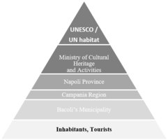 A Pyramid showing the power distribution in terms of size and power variation. For example, the Tourists and inhabitants are the greater populations by size by lies on the bottom of the Power level.


Sacred spaces and heritage
- Which places/elements hold cultural value and to whom?
The territory of Bacoli was founded by the ancient Romans and it is an environmental landscape of exceptional historical value, today the remains of the cisterns of Cento Camerelle, the Grotta of Dragonara and the cistern of Piscina Mirabilis, which constitute the terminal tank of one of the main Roman aqueducts.
Another important historical heritage is the Archaeological Park of Baia, organized on terraces called Terme of Baia (Fig.1). The complex is presented as a series of residences consisting of separate architectural nucleus, organized on different levels of terracing and connected by stepped ramps. Lying towards the sea is the "Villa dell'ambulatio" equipped with a series of terraces connected by a complex of stairs, the last of which leads to the "Mercury sector". The "Temple of Sosandra" is bordered by two parallel staircases. The entire complex originally had marble or black and white mosaic floors.
The lowering of the ground below sea level, due to bradyseism, occurred between the 7th and 8th centuries AD, submerged Baia (Fig.2). Among the most significant remains are some vaulted structures like the great Temple of Diana, the Temple of Mercury and Temple of Venus, it is in any case thermal structures and not places of worship, for which however the popular denomination has survived.
The Temple of Diana which originally defined a large room where vapors from the ground below were collected, was characterized by a colossal ogival dome, now half collapsed. The building was used for thermal purposes and was decorated with marble friezes depicting hunting scenes.
The Temple of Venus rises on the quay of the port of Baia, dated to the Hadrian age. The plant is circular on the inside and octagonal on the outside. It is believed that the monument was part of the thermal plant although today it is no longer possible to grasp this identity because of the modern road. It can be visited simply by locating it among the houses and approaching it.
The Temple of Mercury Also called "truglio" from its circular shape, the building was a frigidarium that is used for cold baths. From the descriptions made of it in the eighteenth century it appeared to be composed of six niches, four of which are semi-circular. The circular vault, equipped with a central lumen, was made with large flakes of tuff shaped like a wedge.
The Aragonese Castle (Fig.3) rises in Baia, a hamlet of Bacoli, and is situated in an area of considerable strategic importance, it was erected on a 51 m promontory naturally defended by a high tuff cliff and by the deep depression given by the caldera of two called volcanoes " Fondi di Baia "with the addition of walls, ditches and drawbridges, the castle was practically impregnable. Its position allowed a very wide control of the area, preventing so much the approach of enemy fleets. Due to its central position relative to the main archaeological sites of the Phlegraean Fields the castle of Baia was chosen as the site of the Archaeological Museum of the Phlegraean Fields.
Along the coast, there are religious monuments such as the Church of San Sossio, the Church of S. Maria del Riposo, the Church of S. Anna Gesù and Maria and the Church of San Gioacchino.
The particularity of the territorial morphology and the phenomenon of bradyseism make the area very interesting for tourists.
- You may add a map and some images, please also explain in your caption why these elements are valuable
-
Fig.1 Terme of Baia
-
Fig.2 Submerged Archaeological park of Baia
-
Fig.3 Aragonese Castle
Visual appearance and landscape narrative
- Which elements are essential for the landscape character?
The landscape is defined by two elements: The Archeological Park and The Aragonese Castle of Baia. The first-mentioned element includes the "Terme di Baia", an antique ensemble which functioned as a thermal resort. Due to its vicinity to Naples, a great urban attractor, Baia has been a secondary center of interest in the area. However, throughout history, it has gone from a small village to a fashionable thermal resort in Antic Roman Republic. Between 100 BC and 500 AD it was well-known for its hedonistic atmosphere and it was better-preferred over area as Pompeii, Capri or Herculaneum.
Aside from its historical and architectural value, The Castle of Baia enriches the landscape by its position - on an upper side of the land - highlighting the natural surroundings."
- Has the landscape been painted or otherwise depicted, when and whom? Which elements are essential?
In painting, Baia is related to the greek and roman mythology. An often pictured subject is the meeting of Apollo and Cumaean Sibyl near the bay of Baia. Cumaen Sibyl is the best known of the 10 sibyls – a “sibyl” is a prophetess, most of the times associated with a particular location. Even though she lived in a cave near the town of Cumae, close to the temple of Apollo, both of them are pictured near the bay of Baia.
Two painters who have approached this subject are Claude Lorraine - a baroque painter - and William Turner in his romantic manner. Each of them, in their own way, chose to paint the mythological story behind Baia. In the case of Turner, mythology itself is a common theme of Romanticism.
The Phlegraean (which includes Baia) area was a key subject for local and foreign painters since the 19th century. The italian painter, Giacinto Gigante has made many paintings inspired by the beautiful landscape of Baia.
- Which narratives exist? Who has written about this landscape or depicted it in some way?
The lost wonders of Baia were a common feature of Romantic poetry. It appears in John Keats's "Ode to May" and in the third stanza of Shelley's "Ode to the West Wind". The vanished columns of the ancient town inundated by the sea is the central conceit of Konstantin Batyushkov's 1819 "You awake, oh Bayya, from the tomb...", "one of his last and finest poems".
The "princely" seaside resort of the empire appears in J. Meade Falkner's 1895 novel The Lost Stradivarius and Anatole France's 1902 "Procurator of Judea" (Le Procurateur de Judée). In current fiction, it is the setting of Caroline Lawrence's Sirens of Surrentum; John Maddox Roberts's Under the Shadow of Vesuvius; Steven Saylor's 1992 Arms of Nemesis, set during the Spartacus Rebellion; and Marguerite Yourcenar's Memoirs of Hadrian.
In the Ecce Romani series of Latin textbooks, Baia is the location of the character Gaius Cornelius Calvus's summer villa.
A forgotten Baia tunnel complex features prominently in the UK series called Forbidden History, whereby the presenter visits a supposed grotto of the Cumaean Sibyl.
Beside the cultural references, there are many tales of intrigue associated with Baia. Rumour has it that Cleopatra escaped in her boat from Baia after Julius Caesar was murdered in 44BC, while Julia Agrippina plotted her husband Claudius’ death at Baia so her son Nero could become emperor of Rome.
Mineral waters and a mild climate first attracted Rome’s nobility to Baia in the latter half of the 2nd Century BC, and the town was known to them as the Phlegraean (or ‘flaming’) Fields, so named because of the calderas that pockmark the region.
-
 Satellite view of the Archeological Park in Baia (source: Google Maps)
 -
 "The Bay of Baiae, with Apollo and the Sibyl", William Turner, 1823 (source: Tate Modern)
 -
 Baia Coast is well known residential area since the Roman Empire and inspired foreign painters as well.Painting by Anton Sminck Pitloo (source:https://ro.pinterest.com)
 -
 Baia, 1850 by Giacinto Gigante (source: https://www.agefotostock.com)


A.2 Summary of you landscape system analysis and your development Targets
-
 DPSIR Analysis of Baia: Two main elements are treatening the future situation of Baia. The always growing flotant population due to an increase of tourism and a Waste Managment Crisis that has been taking place since the early 2000´s. This pressures are attempting to have a negative impact not only in the green landscape but also in the blue infrastructure of the City, which is directly connect to the Cultural Heritage of Baia.

-
 Our hypothesis is a scenario with an overpopulation of tourists and a pooor managment of the waste produced by them. This situation will in high speed deteriorate the landscape and the heritage of Baia

A.3 Theory reflection
- Reflect on at least three international policy documents in relation to their local landscape case
- choose one international, one European and one national document
- You can choose references from our reading list
- Scope: 250 words
A.4 References
- give a full list of the references you have used for this section
Visual appearance and landscape narrative
- https://en.wikipedia.org/wiki/Baiae#History
- https://en.wikipedia.org/wiki/Cumaean_Sibyl#The_caves_at_Cumae_and_Baiae
- http://act.unilink.it/baia-parco-archeologico-delle-terme-napoli/
- https://www.falsi-d-autore.it/marina-c-5426_5445/baia-di-napoli-p-1918.html
- https://www.smithsonianmag.com/history/the-unsolved-mystery-of-the-tunnels-at-baiae-56267963/
- https://journals.openedition.org/mefra/300?lang=es
Phase B: Landscape Evaluation and Assessment
B.1 Assessment Strategy
- GOALS:
Identifying the elements which have a double value – are both risks and potentials.Collecting data and processing it into relevant information. Therefor our mapped themes are archeological sites and natural protected areas

B.2 Mapping
- As defined by your assessment strategy you conduct the mapping and present your findings here
- As a minimum, at least three different themes need to be mapped, you may choose more if needed
-
 This map illustrates the Existing transportation route and mobility analysis. The yellow lines demonstrate the 'Narrow roads inside the city' and they mainly provide access to the residences, shops, no pedestrians or defined bicycle path, have poor road condition, hardly accommodates two cars, one bike and one car can do). The orange route shows"Bigger Roads within the city"(They are spacious enough for cars and buses, but some of them lack footpaths, have adequate surface parking in various pauses). The Redline is to show the route of 'Inter-city connecting highway'(It has access to plenty of bus and cars, the main public transport route, adequate pedestrians, direct link with the beach and exciting view of the sea). The only walkable area along the coastline is adjacent to this highway marked with a light green patch. The dark brown dotted line illustrates 'Only Rail route' or Transit. It has exciting underpass for a long way, no stoppage close to the coast, not enough facility to serve inside the city and coastal zone for the tourist)
 -
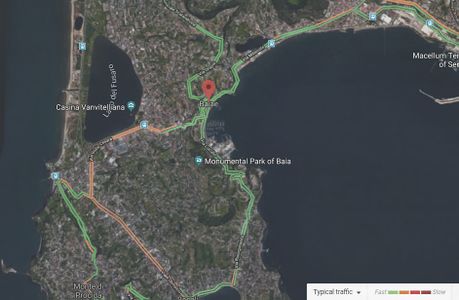 Google Traffic map shows which area has the faster traffic and which area deals generally with the slower traffic inside the city of Baia
 -
 To improve the greenness of a city there is no alternative of public transport, Bi-cycle route to encourage cycling and wide pedestrians to improve the walkability all through the city may bring a charming change to this valuable historic site. Every individual household can contribute to making a green city by planting in front of their houses and by reducing the greyness of the city. The agricultural fields can be opened to the passers-by which will make the walking experience even more eye-soothing and pleasing for the tourists.


B.3 Problem definition and priority setting
- Give a summary of the major findings of your mapping process, what are the problems/potentials identified?
Our major priorities and targets regarding Baia area aim to protect and rehabilitate the Natural Protected Areas Polygon, but also to enhance the mobility and walkability within the city for tourtists and local adding green solutions.
-
 Accessibility to the archeological sites
 -
 Ancient Roman seawater concrete harbor sites, central Italian coast, with Al-tobermorite in relict lime clasts, mid-first century BCE to first century CE.

.png)
B.4 Theory reflection
- Please reflect the assessment and evaluation methods used based on at least three readings
- Did you encounter limitations'
- 200 words test contribution
B.5 References
- Google maps and Google street view of Baia city, Italy; Copyright@2019
- Section and perspective drawing by Amrita U., A., A.
- https://www.researchgate.net
- http://itinerari.baiadinapoli.it
Phase C – Strategy and Master Plan
C.1 Goal Setting
- Through ages, walking under the coast
To reduce energy consumption, To make a balance in facilitating locals and tourists, To ensure better mobility, To encourage walkability and cycling, to take it to forward to a more green city, To connect the scattered heritage sites into a tourism channel
- Link back to your original targets from section one and the Development Goals
- 150 words text contribution
C.2 Spatial Strategy and Transect
- translate your strategic goals into a vision
- develop a spatial translation of your vision
- exemplify your vision in the form of a transect with concrete interventions
- add map(s) and visualizations
Based on the heritage-centered strategy, the main touristic and archeological attractions on Baia should be linked. In our attention was also reducing the energy consumption of car mobility in Baia and outside it, with nearby cities and villages. One of the proposed interventions is creating a pedestrian friendly route between Vanvitelliano Park and Baia Archeological Park, which would be enlivened by three new public spaces. Quality outdoor spaces are vital for rising the attractiveness of Baia for both tourists and inhabitants. This kind of interventions should also have a positive impact on the environment, encouraging pedestrian movement and reducing the use of motorized means of transport.
-
 Urban acupuncture-based approach for Baia
 -
 Public space intervention for 1st area
 -
 Public space intervention for 2nd area
 -
 Public space intervention for 3rd area
 -
 This timeline basically shows the chronological study on Baia city and most effective historic events that made Baia a noteworthy area
 -
 Master plan showing a preliminary sketchy module of route planning and the pedestrian route accessible for tourist and local which will reduce the pressure of traffic on the residential alleys and make the visit for the tourist cost effective walkable and easily movable and more enjoyable. several car parking should be ensured on the face of the pedestrian route and some pauses and functions like plantation, benches and a watchtower on the peak level may ensure tourists interest to take the route. It's close proximity to the historical places in the city will be the principal reason for constructing it.
 -
 Some raw sketches to show how things will make differences and bring activity to the pedestrian route with pauses of sittings or watchtower on the peak may add in the experience of the visitors.
 -
add caption here


C.3 From Theory of Change to Implementation
- Both the archaeology department and the Baia municipality together should work on to implement them?
- Business people should realise the importance and emergence and the huge potential of heritage tourism for Baia, and they should stop random construction within this historical area. Local governance can encourage the people of the city to be more open with their green areas, and make the wine yards welcoming to the visitors so that the existing green infrastructure contribute in the tourism sector and growing economy through the local agriculture
- Heritage should be protected and nature should be honoured and considered at any cost, both tourists and locals life should be balanced in the future plan of tourism for Baia city
- Overall a mass awareness about the value the area and active sensitivity to protect it can be the best solution to all the current problems. Areas like should no more be focusing on industrialization or random construction, rather futuristic prudent approach to save the precious history can serve both the local and the guests of the city. To cope with the global climatic changes there is no alternate of emphasizing on existing green and blue infrastructure along with spreading awareness among people from all sectors.
-
 a collaboration of blue and green infrastructure to make the plan implemented
 -
 A visualization of the pedestrian area of the master plan, with cycle route, walking trail, watching tower pause.


C.4 References
- give a full list of the references you have used for this section
Visual appearance and landscape narrative
- https://www.smithsonianmag.com/history/the-unsolved-mystery-of-the-tunnels-at-baiae-56267963/
- https://journals.openedition.org/mefra/300?lang=es
- https://en.wikipedia.org/wiki/Baiae
D. Process Reflection
- Reflect in your intercultural and interdisciplinary team on the outcomes of your study
- Mostly the communication gap in different time zones. Also the lack of enough land use map in detail, the language barrier.
- to manage things from afar and to work by taking responsibility when no one will be responding following own paths?
- Each week we should fix a mandatory meeting online within a group which will be reported, otherwise, it's hard to gather scattered information about the group and each member's working progress?
- You can also use diagrams/visuals
- 250 words text