Case Study G: Paljassaare-Pikakari: Difference between revisions
| (218 intermediate revisions by 6 users not shown) | |||
| Line 15: | Line 15: | ||
| '''Country''' || style="background:Lavender"|''Estonia'' | | '''Country''' || style="background:Lavender"|''Estonia'' | ||
|- | |- | ||
| '''Topics''' || style="background:Lavender"|'' | | '''Topics''' || style="background:Lavender"|''Recreation, nature area, industry'' | ||
|- | |- | ||
| '''Author(s)''' || style="background:Lavender"|''Constance, Franciska, Hélène, Mohamed, Neda, Pedram'' | | '''Author(s)''' || style="background:Lavender"|''Constance, Franciska, Hélène, Mohamed, Neda, Pedram'' | ||
|- | |- | ||
| colspan="3" align="center" style="background:silver"| [[File: | | colspan="3" align="center" style="background:silver"| [[File:Paljassaare_satellite_view.png|400px]] | ||
|- | |- | ||
| ||style="background:Lavender"| | | ||style="background:Lavender"| | ||
| Line 27: | Line 27: | ||
= Rationale = | = Rationale = | ||
Paljassaare/Pikakari is a strategic site in the thematic of coastal landscapes because it is at the interface of Nature and Human activities. | |||
Indeed, Pikakari is a place close from the city centre (15mn by car) where tourists (mostly Tallinners) go to enjoy the sea and the beach [[//www.google.com/maps]]. | |||
But close to the beach, there is also a Natura 2000 area with more than 80 species of protected birds. Thus, the area is quite fragile and a part of it is forbidden during nesting periods [[http://natura2000.eea.europa.eu]]. | |||
Finally, industry is also present with the waste water treatment plant of Tallinn and Paljassaare port [[https://tallinnavesi.ee/en/corporate-social-responsibility/ekskursioonid/paljassaare-reoveepuhastusjaam/]]. | |||
In conclusion it is a site that can be very conflictual between industry and leisure/nature. Also, because of the activities established, the territory is divided and a long portion of coast on the west side of the Peninsula is not accessible. | |||
The challenge we identified is to make transversal connections across the Peninsula and to develop recreational activities that respect the natural areas (habitats, fauna and flora). | |||
= Location and scope = | = Location and scope = | ||
''You can edit this map with the [[Special:MapEditor|map editor]]'' | ''You can edit this map with the [[Special:MapEditor|map editor]]'' | ||
{{#display_map: | {{#display_map: 59.473955,24.708217~Paljassaare~Location of our Intensive Study Programme | ||
}} | }} | ||
| Line 43: | Line 47: | ||
'' | '' | ||
Paljassaare peninsula is a part of the Tallinn bay and the Gulf of Finland. | Paljassaare peninsula is a part of the Tallinn bay and the Gulf of Finland. | ||
Most of Tallinn bay | Most of Tallinn bay has an artificial coastline. However, the coast of this peninsula is mainly composed with beaches. These are made of sand, pebbles or rocks [http://xgis.maaamet.ee/maps/XGis?app_id=UU82A&user_id=at&LANG=2&WIDTH=1338&HEIGHT=809&zlevel=6,541254.28771977,6593020.8282471]. | ||
The island began to emerge 700 years BC. This area is subjected to an isostatic uplift of the earth crust. It means that this is an area that emerges of around 2 mm every year. | The island began to emerge 700 years BC [https://et.wikipedia.org/wiki/Suur_Paljassaar]. This area is subjected to an isostatic uplift of the earth crust [http://discomap.eea.europa.eu/map/Data/Milieu/OURCOAST_323_EE/OURCOAST_323_EE_Doc_TallinnEurosionCS.pdf]. It means that this is an area that emerges of around 2 mm every year. | ||
Initially the peninsula was divided in two islands. Paljassaare is a peninsula since the 1950s, when garbage was stored in the mud of the bay, between the island and the mainland. | Initially the peninsula was divided in two islands. Paljassaare is a peninsula since the 1950s, when garbage was stored in the mud of the bay, between the island and the mainland. | ||
The location of the site, close to the passage of the boats, makes it vulnerable to waves. The wind also | The location of the site, close to the passage of the boats, makes it vulnerable to waves. The wind also has an impact on the area, as there is no high point to stop it. | ||
Humans also have an impact on the site. It is partly because of the beach. Being close to the city-center, it is well frequented in summer. This brings some pressure on the site, because of the cars. There is also a water treatment plant on the peninsula, which could lead to soil and water pollution.'' | Humans also have an impact on the site. It is partly because of the beach. Being close to the city-center, it is well frequented in summer. This brings some pressure on the site, because of the cars. There is also a water treatment plant on the peninsula, which could lead to soil and water pollution.'' | ||
<gallery caption=" " widths="200px" heights="150px" perrow="5"> | <gallery caption=" " widths="200px" heights="150px" perrow="5"> | ||
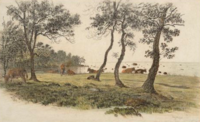
File:Mellin_atlas_von_lieffland_tallinn.png|''Map of the | File:Mellin_atlas_von_lieffland_tallinn.png|''Map of the two Islands from L. A. Mellin's "Atlas von Lieffland" 1798'' [[https://commons.wikimedia.org/wiki/File:Mellin_Atlas_von_Lieffland_Tallinn.png]] | ||
File:Pikakari_rand.JPG|''Pikakari sand beach'' | File:Pikakari_rand.JPG|''Pikakari sand beach'' [[https://vimeo.com/70435719]] | ||
File:Paljassaare_hoiuala._01.jpg|''Sand and pebbles beach'' | File:Paljassaare_hoiuala._01.jpg|''Sand and pebbles beach'' [[https://commons.wikimedia.org/wiki/File:Paljassaare_hoiuala._01.jpg]] | ||
File:Paljassaare_laht_2010-07-14.jpg|''Rocks'' | File:Paljassaare_laht_2010-07-14.jpg|''Rocks'' [[https://commons.wikimedia.org/wiki/File:Paljassaare_laht_2010-07-14.jpg]] | ||
</gallery> | </gallery> | ||
=== Land use === | === Land use === | ||
'' | |||
The territory of Paljaassare is divided into five main land uses : transitional forest with mineral resources, open low and transfer bed, industrial and commercial territories, port and sparsely built up residential areas. Mainly the south part of area is an industrial and commercial unit whereas the north part has rather natural features.'' | |||
<gallery caption=" " widths=" | '' | ||
File:2000.PNG|''2000'' | Predominant land use in the area is industrial and commercial with some settlements, a main road is situated in the east with public transportation (bus connection to the center). According to the development of the area in the past decades, the map shows a visible change : going from shrinking ports bounds and enlarging the industrial area to reaching the coast in the east with settlements. We can say that it is likely that the port area will switch to a residential use in the future. '' | ||
File:2018.PNG|''2018'' | |||
File:Mix_maamet_and_corine.PNG|'''' | |||
<gallery caption=" " widths="150px" heights="200px" perrow="5"> | |||
File:2000.PNG|''Land use map,2000'' [[https://corine.keskkonnaagentuur.ee]] | |||
File:2018.PNG|''land use map,2018'' [[https://corine.keskkonnaagentuur.ee]] | |||
File:123.PNG|''Legend'' | |||
File:Mix_maamet_and_corine.PNG|''Paljassaare'' [[http://xgis.maaamet.ee]] | |||
</gallery> | </gallery> | ||
| Line 72: | Line 80: | ||
1- Paljassaare Special Conservation Area. | 1- Paljassaare Special Conservation Area. | ||
2- | 2- Green zone. | ||
3- Swamp area. | 3- Swamp area. | ||
| Line 79: | Line 87: | ||
4- Pikakari beach. | 4- Pikakari beach. | ||
5- Paljassaare | 5- Paljassaare Harbor. | ||
6- Kaelajarv. | |||
According to the green/blue infrastructure areas mentioned it’s notable that the most of the study area is occupied by industrial use, and the main three green areas (1, 2, 3) is likely to develop in the future, first to maintain the ecological quality of Paljassaare district and eliminate any potential disturbance from the industrial zone, second to increase the connectivity between the green zones and Pikakari beach and the city center. | |||
<gallery caption=" " widths=" | <gallery caption=" " widths="350px" heights="350px" perrow="5"> | ||
File: | File:GreenBlue Infrastructure.jpg|''GreenBlue Infrastructure'' [[https://xgis.maaamet.ee/maps/XGis?app_id=UU82A&user_id=at&LANG=2&WIDTH=1236&HEIGHT=706&zlevel=7,540258.69932335,6593273.77875&setlegend=SHYBR_ALUS01_82A=0,SHYBR_ALUS13_82A=1]] | ||
</gallery> | </gallery> | ||
=== Actors and stakeholders === | === Actors and stakeholders === | ||
Paljassaare peninsula is situated in the North of the municipality of Tallinn, in Harju county. It is part of the Northern Tallinn district. It is quite an industrial area with Tallinn waste treatment plant (Tallinna Vesi - Water of Tallinn - 70 ha) [[https://tallinnavesi.ee/en/corporate-social-responsibility/ekskursioonid/paljassaare-reoveepuhastusjaam/]] [[http://xgis.maaamet.ee/]] and Paljassaare Port belonging to Port of Tallinn (Tallinna Sadam) [[http://www.portoftallinn.com/paljassaare-harbour]] and several transportation companies as well as a railway. Around 50,000 inhabitants are living in the district [[https://www.tallinn.ee/northern-tallinn]]. In Estonia the planning process starts with the national government establishing the legal framework (laws and a national spatial plan). Then, counties do the county spatial plan and municipalities the comprehensive plan. Tallinn has a development plan for the period 2014-2020 [[https://www.tallinn.ee/eng/]]. According to several articles from 2018, Port of Tallinn would be looking to discard its last plots of Paljassaare harbor - most of it already sold over the past 10 years [[https://www.err.ee/842057/tallinna-sadam-paneb-paljassaare-sadama-varad-ilmselt-enampakkumisele]]. | |||
Who is affected highly but with low power? Who has high power but is not affected? | Who is affected highly but with low power? Who has high power but is not affected? | ||
<gallery caption=" " widths=" | <gallery caption=" " widths="350px" heights="350px" perrow="5"> | ||
File:Power_map_Paljassaare.jpg|''Powermap of Paljassaare peninsula'' | File:Power_map_Paljassaare.jpg|''Powermap of Paljassaare peninsula'' | ||
</gallery> | </gallery> | ||
| Line 101: | Line 110: | ||
'' | '' | ||
The cultural heritage of Paljassaare is manly characterized by | The cultural heritage of Paljassaare is manly characterized by its military use. | ||
In the past Paljassaare | In the past Paljassaare was divided into two small islands called Karli Islands. With the end of the Great Northern War on Estonian territory, Estonia was incorporated into Russia. In 1727 the Russian leadership decided to strengthen the defences of the port of Tallinn.[[http://www.portoftallinn.com/18th-century]] At this time the first military fortifications were built on Karli island (later Paljas-saare). | ||
In 1824 an artillery Tower was built on the smaller Karli island. The | In 1824 an artillery Tower was built on the smaller Karli island.[[https://citynature.eu/en/location/paljassaare/?section=history]] The unofficial name of the tower became "White Tower" (Valge torn). Nowadays only ruins of the tower exist since the Russian troops destroyed the Tower during the Crimean War because of the fear that it will fall in the hands of the enemy. | ||
Before and during World War I a complex protecting system was built. The large | Before and during World War I a complex protecting system was built. The large complex of fortifications should protect St. Petersburg form attacks by the sea. The system was called Peter the Great´s naval fortress.[[http://www.estonica.org/en/Peter_the_Great%E2%80%99s_naval_fortress/]] The construction started on Paljassaare in 1912. The area between the mainland and the islands was filled and the result is the peninsula Paljassaare. The material to fill the area was collected during construction of the Mine Harbour.[[http://www.estonica.org/en/History/1914-1920_The_First_World_War_and_Estonian_independence/World_War_I/]] | ||
The construction of the complex protection system was never finished. Today only the ruins of the White Tower, the battery, the embankment of the railway and the Katariina Quay is left from the naval fortress.'' | The construction of the complex protection system was never finished. Today only the ruins of the White Tower, the battery, the embankment of the railway and the Katariina Quay is left from the naval fortress.'' | ||
<gallery caption=" " widths="600px" heights="200px" perrow="5"> | <gallery caption=" " widths="600px" heights="200px" perrow="5"> | ||
File:Zeitstreifen_Gesamt.png|''Timeline of the military history of Paljassaare'' | File:Zeitstreifen_Gesamt.png|''Timeline of the military history of Paljassaare''[[https://et.wikipedia.org/wiki/Paljassaare]] [[http://www.estonica.org/en/History/1558-1710_Estonia_under_Swedish_rule/The_Great_Northern_War_End_of_Swedish_rule_in_Estonia/]] | ||
</gallery> | </gallery> | ||
<gallery caption=" " widths="200px" heights="150px" perrow="5"> | <gallery caption=" " widths="200px" heights="150px" perrow="5"> | ||
File: | File:Kathariina_Quay.JPG|''Kathariina Quay'' | ||
File: | File:Military_fartifications_1.JPG|''Military fortifications on Paljassaare'' | ||
File: | File:Military_fartifications_2.JPG|''Military fortifications on Paljassaare'' | ||
</gallery> | </gallery> | ||
=== Visual appearance and landscape narrative === | === Visual appearance and landscape narrative === | ||
'' | |||
Local visual arts can be considered into three different time periods. The 19th century, Soviet time and Post Soviet time. In the 19th century many landscape painters such as Carl Ferdinand von Kügelgen, Edouard Hostein and Victor-Vincent Adam visited this area and produced many art pieces depicting local nature. In Soviet times many Estonian painters started to show effects of Soviet ideas about human society and lifestyle of young people and next generations. Ilmar Ojalo and especially Jaan Elken are the most important painters from that period, Jaan Elken published more than 200 writings on art and arts policy. Elken has been the head of Estonian Painters’ Union (1995-1999) and the president of Estonian Artists’ Association (1999-2013). Since 1997 he is a professor of the Chair of painting at The Institute of Cultural Research and Fine arts at the University of Tartu. In current time Paljassaare-Pikakari has a new generation of artists who are inspired by new face of this area. They are trying to tell stories from one of the most poorest parts of Tallinn in different ways. Most common medium among them is photography and graffiti, Mattias Malk and Tõnis Saadoja are the most famous young local artists nowadays.'' [[https://soundcloud.com/user-525571669/secret-slum-the-most-safe-place-in-kopli]] | |||
<gallery caption=" " widths="200px" heights="150px" perrow="5"> | <gallery caption=" " widths="200px" heights="150px" perrow="5"> | ||
File: | File:Karl 4.png|''Carl Friedrich Christian Buddeus-Kopli Beach(1836)'' | ||
File: | File:Jaan elken paj.png|''Jaan Elken-Paljassaare(1983)'' | ||
File: | File:Graffiti (1).jpg|''Street Art in Paljassaare peninsula'' | ||
File:Photo 1.png|''Mattias Malk-Secret Slum Book(2017)'' | |||
</gallery> | </gallery> | ||
== A.2 Summary of you landscape system analysis and your development | == A.2 Summary of you landscape system analysis and your development targets == | ||
* | === Summary of the DPSI framework === | ||
* '' | '' | ||
* | ==== DRIVING FORCES ==== | ||
* | '' | ||
* | Human activities : | ||
*Industrial areas | |||
*Tourism >> bird watching area | |||
*Recreational activities at the beach | |||
*Urbanization | |||
Natural processes : | |||
*Waves | |||
*Floods | |||
*Strong Wind'' | |||
==== PRESSURES ==== | |||
'' | |||
*Air pollution | |||
*Heavy Traffic | |||
*Water pollution | |||
*Soil pollution'' | |||
<gallery caption=" " widths=" | ==== STATE ==== | ||
File: | '' | ||
Almost a century ago Paljassaare was divided into two small islands. The area includes abandoned military structures, diverse nature, industry, Paljassaare Harbour and a small area of settlements. In 2005 the Paljassaare Special Conservation Area was established following the guidelines of NATURA 2000. This area has a valuable nature and a unique bird zone. Because of these two facts there is an increasing touristic activity. The Pikakari beach is also a strong magnet for the people of the surroundings, this also implies a lot of individual traffic in this area. The accessibility with public transport system is not well developed. Frequentation of the place is really irregular with a lot of people in the sunny and warm weekends to the beach and almost nobody at others rainy or cooler days. | |||
Paljassaare Harbour will be closed in the future and there are already plans to urbanize the area.[[http://sults.ee/sa-paljassaare-kultuurilaiud-kultuurisaarestiku-tutvustus/]] A big part of Paljassaare is the wastewater treatment plant, almost all the waste water of Tallinn is purified on this place. This industry is likely to stay in place in the long term. Several business and private areas prevent the free access to the coastline and connections from the East to the West.'' | |||
==== IMPACTS ==== | |||
'' | |||
*Air pollution >> bad air quality, which also influence the recreational and protected nature areas | |||
*Popular area >> more disturbances on the protected bird area | |||
*Perturbation of flora and fauna and their life cycles'' | |||
<gallery caption=" " widths="400px" heights="400px" perrow="5"> | |||
File:DPSI_Paljassaare.jpg|''Graphical overview of the DPSI model ''[[https://thenounproject.com]] | |||
</gallery> | </gallery> | ||
<gallery caption=" " widths=" | === Hypothesis === | ||
File: | '' | ||
If all the driving forces just continue as they do, we can image various conflicts. | |||
In the next few years the infrastructure to Paljassaare should be developed, so more people could visit the reserve nature area. In this case we need a balanced development strategy between the improvement of the accessibility and the protection of the nature area in the northern part. The bird watching area includes high valuable ecological elements, which must be protected. In the future the industrial area, especially Paljassaare Harbour should be rebuilt and the emergent area should be urbanized. The existing detail plans will overlap with the nature reserve.[[https://tpr.tallinn.ee/MapOfPlannings/Linnaosa/100276]][[http://adepte.ee/wp-content/uploads/2013/06/24691_phijoonis.pdf]] Also the constructions near to the reserve can have negative effect. The number of nesting birds and species under protection can be unstable.[[https://dspace.emu.ee/xmlui/bitstream/handle/10492/4210/Kruus_Kertu_AR_mag_2018.pdf?sequence=1&isAllowed=y]] | |||
Another risk of high urbanisation on the costal area is that the coastline can lose its function as a public city space. | |||
The rising sea level is a long-term risk. However, possible safety precautions must be considered for future planning as the area has a floodable feature.'' | |||
<gallery caption=" " widths="600px" heights="400px" perrow="5"> | |||
File:Hypothesis_paljassaare.jpg|''Graphical overview of the hypothesis ''[[https://www.envir.ee/sites/default/files/national_adaptation_strategy.pdf]][[http://ec.europa.eu/environment/nature/ecosystems/strategy/index_en.htm]] | |||
</gallery> | </gallery> | ||
=== Sustainable Development Goals === | |||
==== Life below Water ==== | |||
'' | |||
The industry, the increasing urbanisation and the number of visitors at the beach are risks for the goal Life Below Water. The area must struggle with more waste on the beach, water pollution, more traffic and increasing percentage of impervious surface. Those effects are linked with the protection of biodiversity in the coastal areas and in the ocean.''[[https://www.un.org/sustainabledevelopment/oceans/]] | |||
==== Life on Land ==== | |||
'' | |||
The high pressure of urbanisation also endangers the objective Life on Land. The existing development plan shows an overlap with the new housing area and the nature reserve. The development of the urban area must be in balance with nature areas. ''[[https://www.un.org/sustainabledevelopment/biodiversity/]] | |||
== A.3 Theory reflection == | == A.3 Theory reflection == | ||
==== Natura 2000 Birds Directive ==== | |||
* | |||
'' | |||
It is interesting to study the Natura 2000 Birds Directive (Directive 2009/147/EC) [[http://ec.europa.eu/environment/nature/legislation/birdsdirective/index_en.htm]] in our case study because the north of Paljassaare peninsula is a special protection zone of Natura 2000 Birds Directive. This directive, addressing to the states, aims at protecting the 500 species of wild birds living in Europe (194 are threatened) ; and also creating a link between the different countries as migrating birds in particular cross borders. In Paljassaare, 200 birds can be seen, including 50 protected ; some measures can be applied. The habitat should be protected, in order to preserve the birds. No activity with a high impact should be implemented. The establishment of a restricted area during bird nesting show the direct influence of the directive. | |||
'' | |||
<gallery caption=" " widths="700px" heights="200px" perrow="5"> | |||
File:Scheme_Natura_2000_real_final_really_sure.jpg|''Link between natura 2000 guidelines and their implementation in Paljassaare reserve'' | |||
</gallery> | |||
==== Tallinn Environmental Strategy to 2030 ==== | |||
Tallinn is first and foremost a living environment for people while maintaining the natural environment and the health is very important. The planning process is about developing the sustainability of the whole city, therefore the planning development process should take equal account of natural environment alongside artificial environment in the following objectives:- | |||
*Taking into account the long-term trends and the needs for developing in many levels socially, economically, culturally and ecologically. | |||
*Emphasizing on the environment and quality of life in the planning process. | |||
*Developing an efficient strategic environmental assessment not only to provide information to the decision makers but also to help them to pay more attention to the environmental aspect to create more sustainable solutions. | |||
*Achieving the title "Green Capital". | |||
==== Tallinn Development Plan 2014 -2020 ==== | |||
The development Plan is based on the development strategy “Tallinn 2030”. The development plan describes six main objectives.[[https://www.tallinn.ee/eng/]] | |||
* Tallinn with a highly productive economy | |||
* An educated, capable and open Tallinn | |||
* Tallinn with diverse activities and full experiences | |||
* A (socially) safe Tallinn, with managed risks | |||
* Tallinn with comfortable, inspiring and environmentally sound urban space | |||
* Tallinn with effective city agencies that have knowledge-based management and a good service culture | |||
<gallery caption=" " widths="600px" heights="200px" perrow="5"> | |||
File:Theory_Tallinn_Development_Plan.png|''Impacts on Paljassaare'' | |||
</gallery> | |||
==== Guiding Principles for City Climate Action Planning ==== | |||
'' | |||
The Guiding Principles for Climate Action Planning includes guiding principles on city planning level, which can be implemented globally. Climate Action Plans aim to help to reduce greenhouse gas emissions and adapt low emission development. Additionally to adapt the impacts of climate change and build local climate resilience. | |||
City climate action planning should be: | |||
* Ambitious: Setting goals to reach an ambitious vison | |||
* Inclusive: Including city government, stakeholders and communities in all phases of planning and implementation | |||
* Fari: Develop solutions which are equitably address the risk of climate change and share the costs and benefits evenly distribute. | |||
* Comprehensive and integrated: Dynamically adapt to changing conditions within the city and support wider regional initiatives. | |||
* Relevant: Delivering local benefits and supporting local development priorities | |||
* Actionable: Cost-effective actions that can realistically be implemented | |||
* Evidence-based: Reflecting scientific knowledge and local understanding. | |||
* Transparent and verifiable: Open decision-making process with goals that can be measured, reported, independently verified, and evaluated''[[https://unhabitat.org/books/guiding-principles-for-climate-city-planning-action/]] | |||
== A.4 References == | == A.4 References == | ||
==== Rationale ==== | |||
[1] Google maps https://www.google.com/maps | |||
[2] Natura 2000 viewer http://natura2000.eea.europa.eu | |||
[3] Water of Tallinn website https://tallinnavesi.ee/en/corporate-social-responsibility/ekskursioonid/paljassaare-reoveepuhastusjaam/ | |||
==== Geomorphology, landscape units and coastal typology ==== | |||
[4] Maaamet http://xgis.maaamet.ee/maps/XGis?app_id=UU82A&user_id=at&LANG=2&WIDTH=1338&HEIGHT=809&zlevel=6,541254.28771977,6593020.8282471 | |||
[5] Great Paljassaare https://et.wikipedia.org/wiki/Suur_Paljassaar | |||
[6] Eurosion case study http://discomap.eea.europa.eu/map/Data/Milieu/OURCOAST_323_EE/OURCOAST_323_EE_Doc_TallinnEurosionCS.pdf | |||
' | [7] Map of the to Islands from L. A. Mellin's "Atlas von Lieffland" 1798: https://commons.wikimedia.org/wiki/File:Mellin_Atlas_von_Lieffland_Tallinn.png | ||
[8] Picture Pikakari sand beach: https://vimeo.com/70435719 | |||
[9] Picture Sand and pebbles beach: https://commons.wikimedia.org/wiki/File:Paljassaare_hoiuala._01.jpg | |||
[10]Picture Rocks: https://commons.wikimedia.org/wiki/File:Paljassaare_laht_2010-07-14.jpg | |||
==== Land use ==== | |||
[11]1990,2018 https://corine.keskkonnaagentuur.ee/ | |||
[12] http://xgis.maaamet.ee/ | |||
==== Green/blue infrastructure ==== | |||
[13] Maaamet https://xgis.maaamet.ee/maps/XGis?app_id=UU82A&user_id=at&LANG=2&WIDTH=1236&HEIGHT=706&zlevel=7,540258.69932335,6593273.77875&setlegend=SHYBR_ALUS01_82A=0,SHYBR_ALUS13_82A=1 | |||
==== Actors and stakeholders ==== | |||
[14] Tallinna Vesi website https://tallinnavesi.ee/en/corporate-social-responsibility/ekskursioonid/paljassaare-reoveepuhastusjaam/ | |||
[15] Maaamet http://xgis.maaamet.ee/maps/XGis | |||
[16] Paljassaare Port website http://www.portoftallinn.com/paljassaare-harbour | |||
[17] Northern Tallinn District https://www.tallinn.ee/northern-tallinn | |||
[18] Tallinn City website https://www.tallinn.ee/eng/ | |||
[19] Article by Merilin Pärli on err.ee https://www.err.ee/842057/tallinna-sadam-paneb-paljassaare-sadama-varad-ilmselt-enampakkumisele | |||
==== Sacred spaces and heritage ==== | |||
[20] Website Tallinn port: http://www.portoftallinn.com/18th-century | |||
[21] Webportal about urban nature: https://citynature.eu/en/location/paljassaare/?section=history | |||
[22] Wikipedia articl about Paljassaare: https://et.wikipedia.org/wiki/Paljassaare | |||
[23] Website about Estonian history: http://www.estonica.org/en/Peter_the_Great%E2%80%99s_naval_fortress/ | |||
[24] Website about Estonian history: http://www.estonica.org/en/History/1914-1920_The_First_World_War_and_Estonian_independence/World_War_I/ | |||
[25] Website about Estonian history: http://www.estonica.org/en/History/1558-1710_Estonia_under_Swedish_rule/The_Great_Northern_War_End_of_Swedish_rule_in_Estonia/ | |||
==== Visual appearance and landscape narrative ==== | |||
[26] www.mattiasmalk.com http://www.mattiasmalk.com/?section=secret-slum-the-most-safe-place-in-kopli | |||
[27]secret-slum https://soundcloud.com/user-525571669/secret-slum-the-most-safe-place-in-kopli | |||
[28] www.jaanelken.com http://www.jaanelken.com/ | |||
[29] digikogu.ekm.ee https://digikogu.ekm.ee/eng | |||
==== A.2 Summary of your landscape system analysis and your development targets ==== | |||
[30] Website Paljassaare Artificial Island: http://sults.ee/sa-paljassaare-kultuurilaiud-kultuurisaarestiku-tutvustus/ | |||
[31] Icons from Noun Project: https://thenounproject.com | |||
[32] Tallinn plan register: https://tpr.tallinn.ee/MapOfPlannings/Linnaosa/100276 | |||
[33] Settelment plan Paljassaare: http://adepte.ee/wp-content/uploads/2013/06/24691_phijoonis.pdf | |||
[34] Master Thesis PDF: https://dspace.emu.ee/xmlui/bitstream/handle/10492/4210/Kruus_Kertu_AR_mag_2018.pdf?sequence=1&isAllowed=y | |||
[35] Climate Change Adaptation Development Plan until 2030 PDF: https://www.envir.ee/sites/default/files/national_adaptation_strategy.pdf | |||
[36] Website The EU Strategy on Green Infrastructure: http://ec.europa.eu/environment/nature/ecosystems/strategy/index_en.htm | |||
[37] Website about the Sustainable Development Goals: https://www.un.org/sustainabledevelopment/oceans/ | |||
[38] Website about the Sustainable Development Goals: https://www.un.org/sustainabledevelopment/biodiversity/ | |||
==== Theory reflection ==== | |||
[39] Natura 2000 Birds Directive http://ec.europa.eu/environment/nature/legislation/birdsdirective/index_en.htm, PDF document available at : https://eur-lex.europa.eu/legal-content/EN/TXT/?uri=CELEX:32009L0147 | |||
[40] Tallinn Development Plan 2014 -2020 PDF avaiable here: https://www.tallinn.ee/eng/ | |||
[41] Tallinn Environmental Strategy to 2030 https://issuu.com/tallinna_keskkonnaamet/docs/strateegia_ingl | |||
= Phase B: Landscape Evaluation and Assessment = | = Phase B: Landscape Evaluation and Assessment = | ||
== B.1 Assessment Strategy == | == B.1 Assessment Strategy == | ||
As we have seen in the previous phase, the area is undergoing a series of changes. There is a high industrial and urbanization pressure on the peninsula : if the existing housing developments projects are realized, the area will become densely populated. However at the same time, port area gradually disappearing. The Natura 2000 area is an essential part of the green infrastructure : it is very important to support the biodiversity with different types of green space and the unique coastline. In the preceding analyzing phase, the missing connection between the green space of Paljassaare and the surrounding areas turned out. Additionally, the recreational function of the area is very important, but in this context, we identify some issues. The accessibility is insufficiently developed for current use. | |||
Therefore, the main goal is to find a balance between preservation of nature and human activities, in particular recreation. | |||
Based on the outcomes, we defined 3 goals: | |||
1. Protect and preserve the natural areas | |||
2. Develop sustainable housing and services | |||
3. Develop recreation on a large scale | |||
Following maps are important to reach the goals: | |||
1. Landscape character assessment map: this map allows to see clearly what composes the site and what are the on going dynamics . | |||
2. Green space and accessibility at district scale and peninsula scale : they allow to see the links between the green spaces, how the area is reachable and what could be improved. It also reveals the necessity to provide natural spaces to Tallinners for their well-being. These maps also show which spaces could be used for future development (transportation or recreation). | |||
3. Types of settlements: presenting the different types of buildings (industrial and dwelling) to get a better understanding of the area and the ongoing processes in it. | |||
== B.2 Mapping == | == B.2 Mapping == | ||
<gallery caption=" " widths=" | <gallery caption=" " widths="450px" heights="250px" perrow="1"> | ||
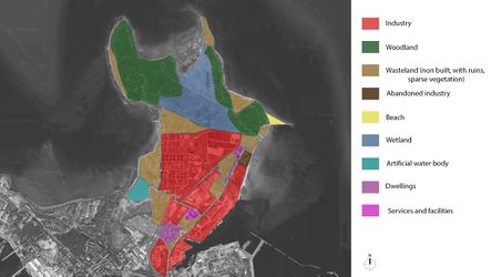
File: | File:LCAJPG.jpg|'''''Landscape character assessment''' : ''This map shows that the area is very fragmented. It is a large area (more than 360 hectares), with a complex network of different uses. It is mainly occupied by industries and natural areas, but there is also some settlements, mostly close to the main road, in the East side of the site. The activities are actually concentrated on the Eastern side of the Peninsula. The amount of under used spaces and wastelands shows that the area is in transformation.''' | ||
File: | File:Greens_large_scaleJPG_final.jpg|'''''Green spaces and accessibility (1)''''' : This map shows accessibility and different types of urban green spaces at the scale of Northern Tallinn district. It shows only one large forest space Merimetsa and the green district of Rocca al Mare/Õismäe. Thus, we notice the necessity to give access to nature to Tallinners and in particular the inhabitants of Kopli peninsula. Then, it also shows the importance of Paljassaare peninsula in Tallinn green infrastructure. Currently, it is not so accessible and it is also quite far from the center. Indeed, it shows a challenge of accessibility by « green » means : public transportation and bikes. | ||
File: | File:Accessibility_and_green_spaces_map_Final_real.jpg|'''''Green spaces and accessibility (2)''' : ''This map shows the accessibility trough the peninsula and the network of the different green spaces. It allows to show which spaces must be protected, and which spaces have the potential to be developed in order to achieve the goals. For example, we can see that the underused plots in the West part of the peninsula are natural areas that could be used to access easily to the reserve. We can also see, along the main street in the East part, that the street is very wide, leaving a lot of space not used but occupied by lawn. Therefore, this side of the site could also have some potential.'' '' | ||
File:SettlementsJPG.jpg|'''''Settlements''''' : This map shows the variety of buildings and settlements in Paljassaare peninsula. There are various industrial areas, a dismantling harbor, abandoned buildings, multi and single family houses and the waste water treatment plant in this site of the Northern Tallinn district. The main challenge is the lack of services for existing residential houses and the ones to come. Indeed, several housing development projects are being discussed to build new houses in the western part of the peninsula. This location need a realistic plan about those types of buildings to make a suitable area for residential development respecting the natural areas of Paljassaare Peninsula. | |||
</gallery> | </gallery> | ||
== B.3 Problem definition and priority setting == | == B.3 Problem definition and priority setting == | ||
<gallery caption=" " widths=" | ====Problems==== | ||
File: | |||
'' | |||
The detailed analysis enabled us to identify the main problems. In the northern part of the peninsula there is the large Natura 2000 area with a rich fauna. While mapping the green spaces in the small and large scale it turned out, that there is no existing connection between the natural areas of the surroundings and the northern part of Paljassaare. The second major issue is the lack of accessibility. We have a lot of heavy and individual traffic in the area. The popularity and closeness of Pikakari Beach to the City causes a lot of traffic in the warmer months, in addition there is a lack of parking spaces. At the same time the public transport and bike network are not developed well. Further, there is a missing connection between Palijassaare and Kopli, it is not possible for pedestrians or bikers to reach the recreational area directly. Also the accessibility to the nature area is not granted for all user groups. We also identified that the range of motion by feet or bike is very small, because of the large scale of the peninsula. Regarding this there is a lack of connections between the western and eastern part of the peninsula. | |||
Most of the build area is covered with industry. The waste water treatment plant is the biggest industry plot and it will not move in the future. Especially in the western part of the plant we identified strong air pollution. The rest of the industry plots are a mixture of intact and abandoned buildings. On those areas soil pollution is to be expected. | |||
====Potentials==== | |||
All the problems also showed us many potentials. Through LCA and green space mapping we figured out, that there are many misused plots. Those areas are possessing a high development potential. They could be used to increase the accessibility, support the green connection between the different green spaces or act as a buffer zone between the recreational and industry areas. | |||
Because of the high value of the nature area, we found out, that there is powerful potential to increase the recreational function. The nature area could act as an educational area, because of the variety of birds.'' | |||
<gallery caption=" " widths="450px" heights="250px" perrow="5"> | |||
File:190502_Risk_and_Potentials.jpg|''Risk and potentials'' | |||
File:Continuity_large_scale_diagram.png|''Potential : connections at large scale'' | |||
</gallery> | |||
====Priorities==== | |||
'' | |||
Based on previous information and analysis our main priority is to develop the accessibility. Developing the general accessibility to the peninsula is very important to improve other functions and problems of the area. For example, when there is a good connection with public transport, we can reduce the individual traffic, decreasing the parking problem and at the same time we enable different user groups to reach the recreational area. Additionally we have to enhance the connection in the nature area to open the area for different user types. | |||
To develop a functional green infrastructure on the peninsula is the second priority. Establishing green corridors between the surrounding natural areas would support the biodiversity of the whole area. There is a high pressure to develop the urban areas in Palijassaare. This is an opportunity and risk at the same time. Building new housing areas could improve the connection between the city and the accessibility. But it also could disturb the nature areas so urbanization rate shouldn't be increased. All the developments on the peninsula should be done in balance with nature.'' | |||
<gallery caption=" " widths="450px" heights="250px" perrow="5"> | |||
File:D_Priorities_and_Targets.jpg|''Priorities'' | |||
</gallery> | </gallery> | ||
| Line 212: | Line 418: | ||
* ''Did you encounter limitations''' | * ''Did you encounter limitations''' | ||
* ''200 words test contribution'' | * ''200 words test contribution'' | ||
As Paljassare is a coastal landscape, it was relevant to read about Coastal Character Assessment. In our process we used the Landscape Character Assessment but in our area and at this scale the two would form one. Indeed, on Paljassaare, the character of the coast is not so affirmed yet because it is really dependent from the functions in the hinterland. As the area is in transformation, the coast is also waiting to define its identity. We understood that the coast is complex and more than physical characteristics described in phase A but also the dimension of experience [[https://www.nature.scot/sites/default/files/2018-07/Guidance%20Note%20-%20Coastal%20Character%20Assessment.pdf]]. | |||
Mapping ecosystems services would also have been a good approach but in a more stable area. However, by projecting a green corridor, we try to spread more evenly on the territory the benefits (services) of green in the different neighborhoods [[https://www.researchgate.net/publication/315074237_What_to_map]]. | |||
Based on previous analysis we had to evaluate the outcomes. In order to characterize the results, we used the SWOT analysis. With the SWOT method we could explore the internal and the external factors that may influence our work and developed a fuller awareness of the situation. This helped us with strategic planning and decision-making for the next phase. | |||
But we had also some difficulties with the SWOT method. It was hard for us to assess the external influences on the region, because it is a complex system of possible influences.[[https://ctb.ku.edu/en/table-of-contents/assessment/assessing-community-needs-and-resources/swot-analysis/main]] | |||
<gallery caption=" " widths="450px" heights="250px" perrow="5"> | |||
File:D_SWOT.jpg|''SWOT method to indetify the potentials and risks'' | |||
</gallery> | |||
== B.5 References == | == B.5 References == | ||
[42] Google maps https://www.google.fr/maps/@59.473895,24.7030839,3198m/data=!3m1!1e3 | |||
[43] Bike way Tallinn - Online Map:http://kaart.tallinn.ee/Tallinn/Show?REQUEST=Main&bbox=524037.5,6578625.0,558512.5,6598575.0&layer=1060&lang=eng&WIDTH=1024&HEIGHT=481 | |||
[44] Icons from Noun Project: https://thenounproject.com | |||
[45] https://www.nature.scot/sites/default/files/2018-07/Guidance%20Note%20-%20Coastal%20Character%20Assessment.pdf | |||
[46] https://www.researchgate.net/publication/315074237_What_to_map | |||
[47] Website about community assessment: https://ctb.ku.edu/en/table-of-contents/assessment/assessing-community-needs-and-resources/swot-analysis/main | |||
=Phase C – Strategy and Master Plan = | =Phase C – Strategy and Master Plan = | ||
== C.1 Goal Setting == | == C.1 Goal Setting == | ||
'' | |||
* | The previous analyses and evaluation findings have confirmed the objectives we already set in Phase B. | ||
* | |||
* Protect and preserve the natural areas | |||
* Develop sustainable housing and services | |||
* Develop recreation on a large scale | |||
The overarching objective is to reach a “Balance between preservation of nature and human activities”. The peninsula has a big potential for different kinds of developments. We have to ensure that all needs are considered in the planning process. | |||
We also set the following objectives linked to the Sustainable Development Goals in Phase A: | |||
* Life below Water | |||
*Life on Land | |||
The chosen themes are both very important to achieve our goals. In order to ensure a balance between nature and human activities, a controlled and sustainable urbanisation must take place. On the other hand, the impact of human activities on the environment must be kept to a minimum. These include in particular the pollution of the sea by garbage or industrial waste water, as well as the general garbage load on the entire peninsula.'' | |||
== C.2 Spatial Strategy and Transect == | == C.2 Spatial Strategy and Transect == | ||
'''Vision''' | |||
'''Paljassaare can become “The Green District” of Tallinn.''' | |||
<gallery caption=" " widths="350px" heights="250px" perrow="1"> | |||
File:The vision.jpg|''Vision for Paljassaare'' | |||
</gallery> | |||
Due to its proximity to the city centre and the great potential for urbanisation, Paljassaare plays an important role in the further development of the city of Tallinn. The increasing housing pressure within the city forces the development of new areas. In our vision we want to emphasize the sustainable and natural urban development. A special feature of the city of Tallinn is the nature reserve, which is included in the northern part of the peninsula. The attractiveness and quality of life for residents and visitors should be increased by an environmentally friendly urbanisation. A further advantage is the linking of the surrounding green areas to a superordinate network, which increases biodiversity. The natural development offers many advantages for humans and for nature and animals. | |||
In order to realise the vision of the Green District, we developed the following objectives: | |||
* Maintaining the ecological quality | |||
* Develop recreational use with improved access | |||
* Sustainable urbanisation | |||
The following diagram shows how we can achieve the goals: | |||
<gallery caption=" " widths="350px" heights="250px" perrow="1"> | |||
File:190529_Planning_Strategy.jpg|''Planning strategy'' | |||
</gallery> | |||
<gallery caption=" " widths="350px" heights="250px" perrow="5"> | |||
File:190527_Masterplan.jpg|''Masterplan'' | |||
</gallery> | |||
<gallery caption=" " widths="350px" heights="250px" perrow="5"> | |||
File:Localisation_of_sections.jpg|''Location of the documents '' | |||
</gallery> | |||
<gallery caption=" " widths="500px" heights="200px" perrow="1"> | <gallery caption=" " widths="500px" heights="200px" perrow="1"> | ||
File: | File:Transect_1_Final_vrai_dernier_.jpg|''East coast transect'' | ||
File: | File:Transect_2_Final_vrai_dernier.jpg|''West coast transect'' | ||
File: | File:190523_Section_Street_01_.jpg|''Detail of the main street'' | ||
File: | File:190524_Section_Prommenade_.jpg|''Sustainable housing with promenade'' | ||
</gallery> | |||
<gallery caption=" " widths="300px" heights="200px" perrow="5"> | |||
File:Parking_current.jpg|''Current parking state (grey, heat island, impervious, saturated)'' | |||
File:Parking_project.jpg|''Projected parking system (reduced car traffic)'' | |||
File:Diagram_parking.jpg|''Diagram of green parking concept (shadow, permeability of the surface)'' | |||
</gallery> | |||
<gallery caption=" " widths="300px" heights="200px" perrow="5"> | |||
File:A-birdwatching-tower.png|''Walk to the birdwatching tower'' | |||
File:83ad2ec0-811d-43e5-97f1-99d8e952335e-600x400.png|''Boardwalk'' | |||
File:Resting_area.png|''Boardwalk with resting area'' | |||
</gallery> | </gallery> | ||
| Line 239: | Line 515: | ||
*''Who needs to act and how? Draw and explain a change/process model/timeline'' | *''Who needs to act and how? Draw and explain a change/process model/timeline'' | ||
*''Which resources are needed? On which assets can you build?'' | *''Which resources are needed? On which assets can you build?'' | ||
Project process requires the action of different stakeholders together. The general framework is given by supra parties such as the government (laws) and Natura 2000 (guidelines). In our case, Tallinn City has a leading role in establishing rules, but also as an actor in the process. Its allies are the investors and the real estate developers, they bring financial feasibility to the project. Also, the developers are responsible for the housing development part of the project on the east coast. | |||
But one category of stakeholders should not be forgotten: the influences. The public should participate and should be consulted at every step of the process. The preservation of the nature reserve is their priority. | |||
<gallery caption=" " widths="500px" heights="200px" perrow="1"> | <gallery caption=" " widths="500px" heights="200px" perrow="1"> | ||
File: | File:Governance_model_20190529.png|''Governance model and stakeholders involved'' | ||
File: | </gallery> | ||
We have drawn priorities about which actions should be first. We divided the construction process into 3 phases, preceded by a phase of reflection and conception. | |||
The biggest problem is the accessibility to the beach. Indeed, in summer the parking areas are totally saturated and people are parking wildly along the street. The street is already not appealing to walk along for pedestrians but then it becomes even more difficult. We want to give more possibilities to go to the beach with the extension of the tramway line and the reduction of car traffic. Also, the sale of port plots to real estate developers is already ongoing. In the meantime, the green corridors and buffer zones welcome new trees because they will take time to establish their structure. | |||
Then a second phase would consist in rehabilitating the grey parkings into green areas with trees and shrubs to provide shadow and reduce impervious surfaces. Also, new trails should be built in the reserve to diversify the trails and target a larger public. Last but not least, once the sale of port plots completed, the construction of the new sustainable neighborhood can begin. | |||
In the last phase, the construction of the access on the west coast starts, it was not a priority, as a path is already existing. Another big part of the project is the promenade. It is an expensive operation that is why it is at the end (it needs funds raised by the real estate operation). Also, it will be easier to construct the promenade once the sustainable neighborhood is built and inhabited. | |||
<gallery caption=" " widths="400px" heights="250px" perrow="5"> | |||
File:Timeline_final_version.jpg|''Timeline of the project'' | |||
</gallery> | </gallery> | ||
== C.4 References == | == C.4 References == | ||
[48] Google maps : https://www.google.fr/maps/@59.473895,24.7030839,3198m/data=!3m1!1e3 | |||
[49] Icons from Noun Project : https://thenounproject.com | |||
[50] Tallinn City website : https://www.tallinn.ee/eng/ | |||
[51] Maaamet : http://xgis.maaamet.ee/maps/XGis?app_id=UU82A&user_id=at&LANG=2&WIDTH=1338&HEIGHT=809&zlevel=6,541254.28771977,6593020.8282471 | |||
= D. Process Reflection = | = D. Process Reflection = | ||
"We believe that the case study in general is a very good method and a useful tool. The structure of the course was good with the materials and the lectures and progressive, it helped us and strengthen our knowledge in spatial planning. | |||
We obtained many outcomes like the fact of learning how to develop methods for comprehensive planning process especially in the local level and how we came across many technical and practical municipal comprehensive planning. | |||
We encountered some limitations through the phases, one of the difficulties we faced is the fact that we have no locals in our group which we had some difficulties in understanding some Estonian documents, in addition the area was large (360 ha) and very complex because of the diversity of functions, the different kinds of landscapes (Harbor, natural area, industrial area, abandoned areas, beach, wetland…) and the fact that the study area was and is still changing and developing rapidly. | |||
It was interesting to work in a diverse group with different backgrounds, cultures and methods. It was beneficial in the work process and in the brain-storming. And for the next time we would try harder to get more feedback and more time for consultations." | |||
Latest revision as of 13:51, 19 March 2020
>>>back to working groups overview
| Area | Paljassaare / Pikakari | |
| Place | Tallinn | |
| Country | Estonia | |
| Topics | Recreation, nature area, industry | |
| Author(s) | Constance, Franciska, Hélène, Mohamed, Neda, Pedram | |

| ||
Rationale
Paljassaare/Pikakari is a strategic site in the thematic of coastal landscapes because it is at the interface of Nature and Human activities. Indeed, Pikakari is a place close from the city centre (15mn by car) where tourists (mostly Tallinners) go to enjoy the sea and the beach [[14]]. But close to the beach, there is also a Natura 2000 area with more than 80 species of protected birds. Thus, the area is quite fragile and a part of it is forbidden during nesting periods [[15]]. Finally, industry is also present with the waste water treatment plant of Tallinn and Paljassaare port [[16]]. In conclusion it is a site that can be very conflictual between industry and leisure/nature. Also, because of the activities established, the territory is divided and a long portion of coast on the west side of the Peninsula is not accessible. The challenge we identified is to make transversal connections across the Peninsula and to develop recreational activities that respect the natural areas (habitats, fauna and flora).
Location and scope
You can edit this map with the map editor
A Landscape System Analysis
A.1 Landscape layers and their system context
Geomorphology, landscape units and coastal typology
Paljassaare peninsula is a part of the Tallinn bay and the Gulf of Finland. Most of Tallinn bay has an artificial coastline. However, the coast of this peninsula is mainly composed with beaches. These are made of sand, pebbles or rocks [17]. The island began to emerge 700 years BC [18]. This area is subjected to an isostatic uplift of the earth crust [19]. It means that this is an area that emerges of around 2 mm every year. Initially the peninsula was divided in two islands. Paljassaare is a peninsula since the 1950s, when garbage was stored in the mud of the bay, between the island and the mainland. The location of the site, close to the passage of the boats, makes it vulnerable to waves. The wind also has an impact on the area, as there is no high point to stop it. Humans also have an impact on the site. It is partly because of the beach. Being close to the city-center, it is well frequented in summer. This brings some pressure on the site, because of the cars. There is also a water treatment plant on the peninsula, which could lead to soil and water pollution.
-
![Map of the two Islands from L. A. Mellin's "Atlas von Lieffland" 1798 [[1]]](/images/thumb/b/bd/Mellin_atlas_von_lieffland_tallinn.png/103px-Mellin_atlas_von_lieffland_tallinn.png) Map of the two Islands from L. A. Mellin's "Atlas von Lieffland" 1798 [[1]]
Map of the two Islands from L. A. Mellin's "Atlas von Lieffland" 1798 [[1]] -
![Pikakari sand beach [[2]]](/images/thumb/c/c5/Pikakari_rand.JPG/200px-Pikakari_rand.JPG) Pikakari sand beach [[2]]
Pikakari sand beach [[2]] -
![Sand and pebbles beach [[3]]](/images/thumb/9/98/Paljassaare_hoiuala._01.jpg/200px-Paljassaare_hoiuala._01.jpg) Sand and pebbles beach [[3]]
Sand and pebbles beach [[3]] -
![Rocks [[4]]](/images/thumb/a/ac/Paljassaare_laht_2010-07-14.jpg/200px-Paljassaare_laht_2010-07-14.jpg) Rocks [[4]]
Rocks [[4]]
![Map of the two Islands from L. A. Mellin's "Atlas von Lieffland" 1798 [[1]]](/index.php?title=File:Mellin_atlas_von_lieffland_tallinn.png)
![Pikakari sand beach [[2]]](/index.php?title=File:Pikakari_rand.JPG)
![Sand and pebbles beach [[3]]](/index.php?title=File:Paljassaare_hoiuala._01.jpg)
![Rocks [[4]]](/index.php?title=File:Paljassaare_laht_2010-07-14.jpg)
Land use
The territory of Paljaassare is divided into five main land uses : transitional forest with mineral resources, open low and transfer bed, industrial and commercial territories, port and sparsely built up residential areas. Mainly the south part of area is an industrial and commercial unit whereas the north part has rather natural features.
Predominant land use in the area is industrial and commercial with some settlements, a main road is situated in the east with public transportation (bus connection to the center). According to the development of the area in the past decades, the map shows a visible change : going from shrinking ports bounds and enlarging the industrial area to reaching the coast in the east with settlements. We can say that it is likely that the port area will switch to a residential use in the future.
![Land use map,2000 [[5]]](/index.php?title=File:2000.PNG)
![land use map,2018 [[6]]](/index.php?title=File:2018.PNG)

![Paljassaare [[7]]](/index.php?title=File:Mix_maamet_and_corine.PNG)
Green/blue infrastructure
- Main green infrastructure:-
1- Paljassaare Special Conservation Area.
2- Green zone.
3- Swamp area.
- Main blue infrastructure:-
4- Pikakari beach.
5- Paljassaare Harbor.
6- Kaelajarv.
According to the green/blue infrastructure areas mentioned it’s notable that the most of the study area is occupied by industrial use, and the main three green areas (1, 2, 3) is likely to develop in the future, first to maintain the ecological quality of Paljassaare district and eliminate any potential disturbance from the industrial zone, second to increase the connectivity between the green zones and Pikakari beach and the city center.
-
![GreenBlue Infrastructure [[8]]](/images/thumb/8/8d/GreenBlue_Infrastructure.jpg/350px-GreenBlue_Infrastructure.jpg) GreenBlue Infrastructure [[8]]
GreenBlue Infrastructure [[8]]
![GreenBlue Infrastructure [[8]]](/index.php?title=File:GreenBlue_Infrastructure.jpg)
Actors and stakeholders
Paljassaare peninsula is situated in the North of the municipality of Tallinn, in Harju county. It is part of the Northern Tallinn district. It is quite an industrial area with Tallinn waste treatment plant (Tallinna Vesi - Water of Tallinn - 70 ha) [[20]] [[21]] and Paljassaare Port belonging to Port of Tallinn (Tallinna Sadam) [[22]] and several transportation companies as well as a railway. Around 50,000 inhabitants are living in the district [[23]]. In Estonia the planning process starts with the national government establishing the legal framework (laws and a national spatial plan). Then, counties do the county spatial plan and municipalities the comprehensive plan. Tallinn has a development plan for the period 2014-2020 [[24]]. According to several articles from 2018, Port of Tallinn would be looking to discard its last plots of Paljassaare harbor - most of it already sold over the past 10 years [[25]].
Who is affected highly but with low power? Who has high power but is not affected?
-
 Powermap of Paljassaare peninsula

Sacred spaces and heritage
The cultural heritage of Paljassaare is manly characterized by its military use. In the past Paljassaare was divided into two small islands called Karli Islands. With the end of the Great Northern War on Estonian territory, Estonia was incorporated into Russia. In 1727 the Russian leadership decided to strengthen the defences of the port of Tallinn.[[26]] At this time the first military fortifications were built on Karli island (later Paljas-saare). In 1824 an artillery Tower was built on the smaller Karli island.[[27]] The unofficial name of the tower became "White Tower" (Valge torn). Nowadays only ruins of the tower exist since the Russian troops destroyed the Tower during the Crimean War because of the fear that it will fall in the hands of the enemy. Before and during World War I a complex protecting system was built. The large complex of fortifications should protect St. Petersburg form attacks by the sea. The system was called Peter the Great´s naval fortress.[[28]] The construction started on Paljassaare in 1912. The area between the mainland and the islands was filled and the result is the peninsula Paljassaare. The material to fill the area was collected during construction of the Mine Harbour.[[29]] The construction of the complex protection system was never finished. Today only the ruins of the White Tower, the battery, the embankment of the railway and the Katariina Quay is left from the naval fortress.
![Timeline of the military history of Paljassaare[[9]] [[10]]](/index.php?title=File:Zeitstreifen_Gesamt.png)
-
 Kathariina Quay
 -
 Military fortifications on Paljassaare
 -
 Military fortifications on Paljassaare


Visual appearance and landscape narrative
Local visual arts can be considered into three different time periods. The 19th century, Soviet time and Post Soviet time. In the 19th century many landscape painters such as Carl Ferdinand von Kügelgen, Edouard Hostein and Victor-Vincent Adam visited this area and produced many art pieces depicting local nature. In Soviet times many Estonian painters started to show effects of Soviet ideas about human society and lifestyle of young people and next generations. Ilmar Ojalo and especially Jaan Elken are the most important painters from that period, Jaan Elken published more than 200 writings on art and arts policy. Elken has been the head of Estonian Painters’ Union (1995-1999) and the president of Estonian Artists’ Association (1999-2013). Since 1997 he is a professor of the Chair of painting at The Institute of Cultural Research and Fine arts at the University of Tartu. In current time Paljassaare-Pikakari has a new generation of artists who are inspired by new face of this area. They are trying to tell stories from one of the most poorest parts of Tallinn in different ways. Most common medium among them is photography and graffiti, Mattias Malk and Tõnis Saadoja are the most famous young local artists nowadays. [[30]]
-
 Carl Friedrich Christian Buddeus-Kopli Beach(1836)
 -
 Jaan Elken-Paljassaare(1983)
 -
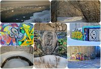 Street Art in Paljassaare peninsula
 -
 Mattias Malk-Secret Slum Book(2017)


.jpg)

A.2 Summary of you landscape system analysis and your development targets
Summary of the DPSI framework
DRIVING FORCES
Human activities :
- Industrial areas
- Tourism >> bird watching area
- Recreational activities at the beach
- Urbanization
Natural processes :
- Waves
- Floods
- Strong Wind
PRESSURES
- Air pollution
- Heavy Traffic
- Water pollution
- Soil pollution
STATE
Almost a century ago Paljassaare was divided into two small islands. The area includes abandoned military structures, diverse nature, industry, Paljassaare Harbour and a small area of settlements. In 2005 the Paljassaare Special Conservation Area was established following the guidelines of NATURA 2000. This area has a valuable nature and a unique bird zone. Because of these two facts there is an increasing touristic activity. The Pikakari beach is also a strong magnet for the people of the surroundings, this also implies a lot of individual traffic in this area. The accessibility with public transport system is not well developed. Frequentation of the place is really irregular with a lot of people in the sunny and warm weekends to the beach and almost nobody at others rainy or cooler days. Paljassaare Harbour will be closed in the future and there are already plans to urbanize the area.[[31]] A big part of Paljassaare is the wastewater treatment plant, almost all the waste water of Tallinn is purified on this place. This industry is likely to stay in place in the long term. Several business and private areas prevent the free access to the coastline and connections from the East to the West.
IMPACTS
- Air pollution >> bad air quality, which also influence the recreational and protected nature areas
- Popular area >> more disturbances on the protected bird area
- Perturbation of flora and fauna and their life cycles
-
![Graphical overview of the DPSI model [[11]]](/images/thumb/5/5c/DPSI_Paljassaare.jpg/400px-DPSI_Paljassaare.jpg) Graphical overview of the DPSI model [[11]]
Graphical overview of the DPSI model [[11]]
![Graphical overview of the DPSI model [[11]]](/index.php?title=File:DPSI_Paljassaare.jpg)
Hypothesis
If all the driving forces just continue as they do, we can image various conflicts. In the next few years the infrastructure to Paljassaare should be developed, so more people could visit the reserve nature area. In this case we need a balanced development strategy between the improvement of the accessibility and the protection of the nature area in the northern part. The bird watching area includes high valuable ecological elements, which must be protected. In the future the industrial area, especially Paljassaare Harbour should be rebuilt and the emergent area should be urbanized. The existing detail plans will overlap with the nature reserve.[[32]][[33]] Also the constructions near to the reserve can have negative effect. The number of nesting birds and species under protection can be unstable.[[34]] Another risk of high urbanisation on the costal area is that the coastline can lose its function as a public city space. The rising sea level is a long-term risk. However, possible safety precautions must be considered for future planning as the area has a floodable feature.
![Graphical overview of the hypothesis [[12]][[13]]](/index.php?title=File:Hypothesis_paljassaare.jpg)
Sustainable Development Goals
Life below Water
The industry, the increasing urbanisation and the number of visitors at the beach are risks for the goal Life Below Water. The area must struggle with more waste on the beach, water pollution, more traffic and increasing percentage of impervious surface. Those effects are linked with the protection of biodiversity in the coastal areas and in the ocean.[[35]]
Life on Land
The high pressure of urbanisation also endangers the objective Life on Land. The existing development plan shows an overlap with the new housing area and the nature reserve. The development of the urban area must be in balance with nature areas. [[36]]
A.3 Theory reflection
Natura 2000 Birds Directive
It is interesting to study the Natura 2000 Birds Directive (Directive 2009/147/EC) [[37]] in our case study because the north of Paljassaare peninsula is a special protection zone of Natura 2000 Birds Directive. This directive, addressing to the states, aims at protecting the 500 species of wild birds living in Europe (194 are threatened) ; and also creating a link between the different countries as migrating birds in particular cross borders. In Paljassaare, 200 birds can be seen, including 50 protected ; some measures can be applied. The habitat should be protected, in order to preserve the birds. No activity with a high impact should be implemented. The establishment of a restricted area during bird nesting show the direct influence of the directive.
-
 Link between natura 2000 guidelines and their implementation in Paljassaare reserve

Tallinn Environmental Strategy to 2030
Tallinn is first and foremost a living environment for people while maintaining the natural environment and the health is very important. The planning process is about developing the sustainability of the whole city, therefore the planning development process should take equal account of natural environment alongside artificial environment in the following objectives:-
- Taking into account the long-term trends and the needs for developing in many levels socially, economically, culturally and ecologically.
- Emphasizing on the environment and quality of life in the planning process.
- Developing an efficient strategic environmental assessment not only to provide information to the decision makers but also to help them to pay more attention to the environmental aspect to create more sustainable solutions.
- Achieving the title "Green Capital".
Tallinn Development Plan 2014 -2020
The development Plan is based on the development strategy “Tallinn 2030”. The development plan describes six main objectives.[[38]]
- Tallinn with a highly productive economy
- An educated, capable and open Tallinn
- Tallinn with diverse activities and full experiences
- A (socially) safe Tallinn, with managed risks
- Tallinn with comfortable, inspiring and environmentally sound urban space
- Tallinn with effective city agencies that have knowledge-based management and a good service culture
-
 Impacts on Paljassaare

Guiding Principles for City Climate Action Planning
The Guiding Principles for Climate Action Planning includes guiding principles on city planning level, which can be implemented globally. Climate Action Plans aim to help to reduce greenhouse gas emissions and adapt low emission development. Additionally to adapt the impacts of climate change and build local climate resilience.
City climate action planning should be:
- Ambitious: Setting goals to reach an ambitious vison
- Inclusive: Including city government, stakeholders and communities in all phases of planning and implementation
- Fari: Develop solutions which are equitably address the risk of climate change and share the costs and benefits evenly distribute.
- Comprehensive and integrated: Dynamically adapt to changing conditions within the city and support wider regional initiatives.
- Relevant: Delivering local benefits and supporting local development priorities
- Actionable: Cost-effective actions that can realistically be implemented
- Evidence-based: Reflecting scientific knowledge and local understanding.
- Transparent and verifiable: Open decision-making process with goals that can be measured, reported, independently verified, and evaluated[[39]]
A.4 References
Rationale
[1] Google maps https://www.google.com/maps
[2] Natura 2000 viewer http://natura2000.eea.europa.eu
[3] Water of Tallinn website https://tallinnavesi.ee/en/corporate-social-responsibility/ekskursioonid/paljassaare-reoveepuhastusjaam/
Geomorphology, landscape units and coastal typology
[5] Great Paljassaare https://et.wikipedia.org/wiki/Suur_Paljassaar
[6] Eurosion case study http://discomap.eea.europa.eu/map/Data/Milieu/OURCOAST_323_EE/OURCOAST_323_EE_Doc_TallinnEurosionCS.pdf
[7] Map of the to Islands from L. A. Mellin's "Atlas von Lieffland" 1798: https://commons.wikimedia.org/wiki/File:Mellin_Atlas_von_Lieffland_Tallinn.png
[8] Picture Pikakari sand beach: https://vimeo.com/70435719
[9] Picture Sand and pebbles beach: https://commons.wikimedia.org/wiki/File:Paljassaare_hoiuala._01.jpg
[10]Picture Rocks: https://commons.wikimedia.org/wiki/File:Paljassaare_laht_2010-07-14.jpg
Land use
[11]1990,2018 https://corine.keskkonnaagentuur.ee/
Green/blue infrastructure
Actors and stakeholders
[14] Tallinna Vesi website https://tallinnavesi.ee/en/corporate-social-responsibility/ekskursioonid/paljassaare-reoveepuhastusjaam/
[15] Maaamet http://xgis.maaamet.ee/maps/XGis
[16] Paljassaare Port website http://www.portoftallinn.com/paljassaare-harbour
[17] Northern Tallinn District https://www.tallinn.ee/northern-tallinn
[18] Tallinn City website https://www.tallinn.ee/eng/
[19] Article by Merilin Pärli on err.ee https://www.err.ee/842057/tallinna-sadam-paneb-paljassaare-sadama-varad-ilmselt-enampakkumisele
Sacred spaces and heritage
[20] Website Tallinn port: http://www.portoftallinn.com/18th-century
[21] Webportal about urban nature: https://citynature.eu/en/location/paljassaare/?section=history
[22] Wikipedia articl about Paljassaare: https://et.wikipedia.org/wiki/Paljassaare
[23] Website about Estonian history: http://www.estonica.org/en/Peter_the_Great%E2%80%99s_naval_fortress/
[24] Website about Estonian history: http://www.estonica.org/en/History/1914-1920_The_First_World_War_and_Estonian_independence/World_War_I/
[25] Website about Estonian history: http://www.estonica.org/en/History/1558-1710_Estonia_under_Swedish_rule/The_Great_Northern_War_End_of_Swedish_rule_in_Estonia/
Visual appearance and landscape narrative
[26] www.mattiasmalk.com http://www.mattiasmalk.com/?section=secret-slum-the-most-safe-place-in-kopli
[27]secret-slum https://soundcloud.com/user-525571669/secret-slum-the-most-safe-place-in-kopli
[28] www.jaanelken.com http://www.jaanelken.com/
[29] digikogu.ekm.ee https://digikogu.ekm.ee/eng
A.2 Summary of your landscape system analysis and your development targets
[30] Website Paljassaare Artificial Island: http://sults.ee/sa-paljassaare-kultuurilaiud-kultuurisaarestiku-tutvustus/
[31] Icons from Noun Project: https://thenounproject.com
[32] Tallinn plan register: https://tpr.tallinn.ee/MapOfPlannings/Linnaosa/100276
[33] Settelment plan Paljassaare: http://adepte.ee/wp-content/uploads/2013/06/24691_phijoonis.pdf
[34] Master Thesis PDF: https://dspace.emu.ee/xmlui/bitstream/handle/10492/4210/Kruus_Kertu_AR_mag_2018.pdf?sequence=1&isAllowed=y
[35] Climate Change Adaptation Development Plan until 2030 PDF: https://www.envir.ee/sites/default/files/national_adaptation_strategy.pdf
[36] Website The EU Strategy on Green Infrastructure: http://ec.europa.eu/environment/nature/ecosystems/strategy/index_en.htm
[37] Website about the Sustainable Development Goals: https://www.un.org/sustainabledevelopment/oceans/
[38] Website about the Sustainable Development Goals: https://www.un.org/sustainabledevelopment/biodiversity/
Theory reflection
[39] Natura 2000 Birds Directive http://ec.europa.eu/environment/nature/legislation/birdsdirective/index_en.htm, PDF document available at : https://eur-lex.europa.eu/legal-content/EN/TXT/?uri=CELEX:32009L0147
[40] Tallinn Development Plan 2014 -2020 PDF avaiable here: https://www.tallinn.ee/eng/
[41] Tallinn Environmental Strategy to 2030 https://issuu.com/tallinna_keskkonnaamet/docs/strateegia_ingl
Phase B: Landscape Evaluation and Assessment
B.1 Assessment Strategy
As we have seen in the previous phase, the area is undergoing a series of changes. There is a high industrial and urbanization pressure on the peninsula : if the existing housing developments projects are realized, the area will become densely populated. However at the same time, port area gradually disappearing. The Natura 2000 area is an essential part of the green infrastructure : it is very important to support the biodiversity with different types of green space and the unique coastline. In the preceding analyzing phase, the missing connection between the green space of Paljassaare and the surrounding areas turned out. Additionally, the recreational function of the area is very important, but in this context, we identify some issues. The accessibility is insufficiently developed for current use. Therefore, the main goal is to find a balance between preservation of nature and human activities, in particular recreation. Based on the outcomes, we defined 3 goals:
1. Protect and preserve the natural areas
2. Develop sustainable housing and services
3. Develop recreation on a large scale
Following maps are important to reach the goals:
1. Landscape character assessment map: this map allows to see clearly what composes the site and what are the on going dynamics .
2. Green space and accessibility at district scale and peninsula scale : they allow to see the links between the green spaces, how the area is reachable and what could be improved. It also reveals the necessity to provide natural spaces to Tallinners for their well-being. These maps also show which spaces could be used for future development (transportation or recreation).
3. Types of settlements: presenting the different types of buildings (industrial and dwelling) to get a better understanding of the area and the ongoing processes in it.
B.2 Mapping
-
 Landscape character assessment : This map shows that the area is very fragmented. It is a large area (more than 360 hectares), with a complex network of different uses. It is mainly occupied by industries and natural areas, but there is also some settlements, mostly close to the main road, in the East side of the site. The activities are actually concentrated on the Eastern side of the Peninsula. The amount of under used spaces and wastelands shows that the area is in transformation.
 -
 Green spaces and accessibility (1) : This map shows accessibility and different types of urban green spaces at the scale of Northern Tallinn district. It shows only one large forest space Merimetsa and the green district of Rocca al Mare/Õismäe. Thus, we notice the necessity to give access to nature to Tallinners and in particular the inhabitants of Kopli peninsula. Then, it also shows the importance of Paljassaare peninsula in Tallinn green infrastructure. Currently, it is not so accessible and it is also quite far from the center. Indeed, it shows a challenge of accessibility by « green » means : public transportation and bikes.
 -
 Green spaces and accessibility (2) : This map shows the accessibility trough the peninsula and the network of the different green spaces. It allows to show which spaces must be protected, and which spaces have the potential to be developed in order to achieve the goals. For example, we can see that the underused plots in the West part of the peninsula are natural areas that could be used to access easily to the reserve. We can also see, along the main street in the East part, that the street is very wide, leaving a lot of space not used but occupied by lawn. Therefore, this side of the site could also have some potential.
 -
 Settlements : This map shows the variety of buildings and settlements in Paljassaare peninsula. There are various industrial areas, a dismantling harbor, abandoned buildings, multi and single family houses and the waste water treatment plant in this site of the Northern Tallinn district. The main challenge is the lack of services for existing residential houses and the ones to come. Indeed, several housing development projects are being discussed to build new houses in the western part of the peninsula. This location need a realistic plan about those types of buildings to make a suitable area for residential development respecting the natural areas of Paljassaare Peninsula.


B.3 Problem definition and priority setting
Problems
The detailed analysis enabled us to identify the main problems. In the northern part of the peninsula there is the large Natura 2000 area with a rich fauna. While mapping the green spaces in the small and large scale it turned out, that there is no existing connection between the natural areas of the surroundings and the northern part of Paljassaare. The second major issue is the lack of accessibility. We have a lot of heavy and individual traffic in the area. The popularity and closeness of Pikakari Beach to the City causes a lot of traffic in the warmer months, in addition there is a lack of parking spaces. At the same time the public transport and bike network are not developed well. Further, there is a missing connection between Palijassaare and Kopli, it is not possible for pedestrians or bikers to reach the recreational area directly. Also the accessibility to the nature area is not granted for all user groups. We also identified that the range of motion by feet or bike is very small, because of the large scale of the peninsula. Regarding this there is a lack of connections between the western and eastern part of the peninsula. Most of the build area is covered with industry. The waste water treatment plant is the biggest industry plot and it will not move in the future. Especially in the western part of the plant we identified strong air pollution. The rest of the industry plots are a mixture of intact and abandoned buildings. On those areas soil pollution is to be expected.
Potentials
All the problems also showed us many potentials. Through LCA and green space mapping we figured out, that there are many misused plots. Those areas are possessing a high development potential. They could be used to increase the accessibility, support the green connection between the different green spaces or act as a buffer zone between the recreational and industry areas. Because of the high value of the nature area, we found out, that there is powerful potential to increase the recreational function. The nature area could act as an educational area, because of the variety of birds.
-
 Risk and potentials
 -
 Potential : connections at large scale


Priorities
Based on previous information and analysis our main priority is to develop the accessibility. Developing the general accessibility to the peninsula is very important to improve other functions and problems of the area. For example, when there is a good connection with public transport, we can reduce the individual traffic, decreasing the parking problem and at the same time we enable different user groups to reach the recreational area. Additionally we have to enhance the connection in the nature area to open the area for different user types. To develop a functional green infrastructure on the peninsula is the second priority. Establishing green corridors between the surrounding natural areas would support the biodiversity of the whole area. There is a high pressure to develop the urban areas in Palijassaare. This is an opportunity and risk at the same time. Building new housing areas could improve the connection between the city and the accessibility. But it also could disturb the nature areas so urbanization rate shouldn't be increased. All the developments on the peninsula should be done in balance with nature.
-
 Priorities

B.4 Theory reflection
- Please reflect the assessment and evaluation methods used based on at least three readings
- Did you encounter limitations'
- 200 words test contribution
As Paljassare is a coastal landscape, it was relevant to read about Coastal Character Assessment. In our process we used the Landscape Character Assessment but in our area and at this scale the two would form one. Indeed, on Paljassaare, the character of the coast is not so affirmed yet because it is really dependent from the functions in the hinterland. As the area is in transformation, the coast is also waiting to define its identity. We understood that the coast is complex and more than physical characteristics described in phase A but also the dimension of experience [[40]].
Mapping ecosystems services would also have been a good approach but in a more stable area. However, by projecting a green corridor, we try to spread more evenly on the territory the benefits (services) of green in the different neighborhoods [[41]].
Based on previous analysis we had to evaluate the outcomes. In order to characterize the results, we used the SWOT analysis. With the SWOT method we could explore the internal and the external factors that may influence our work and developed a fuller awareness of the situation. This helped us with strategic planning and decision-making for the next phase. But we had also some difficulties with the SWOT method. It was hard for us to assess the external influences on the region, because it is a complex system of possible influences.[[42]]
-
 SWOT method to indetify the potentials and risks

B.5 References
[42] Google maps https://www.google.fr/maps/@59.473895,24.7030839,3198m/data=!3m1!1e3
[43] Bike way Tallinn - Online Map:http://kaart.tallinn.ee/Tallinn/Show?REQUEST=Main&bbox=524037.5,6578625.0,558512.5,6598575.0&layer=1060&lang=eng&WIDTH=1024&HEIGHT=481
[44] Icons from Noun Project: https://thenounproject.com
[46] https://www.researchgate.net/publication/315074237_What_to_map
[47] Website about community assessment: https://ctb.ku.edu/en/table-of-contents/assessment/assessing-community-needs-and-resources/swot-analysis/main
Phase C – Strategy and Master Plan
C.1 Goal Setting
The previous analyses and evaluation findings have confirmed the objectives we already set in Phase B.
- Protect and preserve the natural areas
- Develop sustainable housing and services
- Develop recreation on a large scale
The overarching objective is to reach a “Balance between preservation of nature and human activities”. The peninsula has a big potential for different kinds of developments. We have to ensure that all needs are considered in the planning process. We also set the following objectives linked to the Sustainable Development Goals in Phase A:
- Life below Water
- Life on Land
The chosen themes are both very important to achieve our goals. In order to ensure a balance between nature and human activities, a controlled and sustainable urbanisation must take place. On the other hand, the impact of human activities on the environment must be kept to a minimum. These include in particular the pollution of the sea by garbage or industrial waste water, as well as the general garbage load on the entire peninsula.
C.2 Spatial Strategy and Transect
Vision
Paljassaare can become “The Green District” of Tallinn.
-
 Vision for Paljassaare

Due to its proximity to the city centre and the great potential for urbanisation, Paljassaare plays an important role in the further development of the city of Tallinn. The increasing housing pressure within the city forces the development of new areas. In our vision we want to emphasize the sustainable and natural urban development. A special feature of the city of Tallinn is the nature reserve, which is included in the northern part of the peninsula. The attractiveness and quality of life for residents and visitors should be increased by an environmentally friendly urbanisation. A further advantage is the linking of the surrounding green areas to a superordinate network, which increases biodiversity. The natural development offers many advantages for humans and for nature and animals.
In order to realise the vision of the Green District, we developed the following objectives:
- Maintaining the ecological quality
- Develop recreational use with improved access
- Sustainable urbanisation
The following diagram shows how we can achieve the goals:
-
 Planning strategy

-
 Masterplan

-
 Location of the documents

-
 East coast transect
 -
 West coast transect
 -
 Detail of the main street
 -
 Sustainable housing with promenade


-
 Current parking state (grey, heat island, impervious, saturated)
 -
 Projected parking system (reduced car traffic)
 -
 Diagram of green parking concept (shadow, permeability of the surface)


-
 Walk to the birdwatching tower
 -
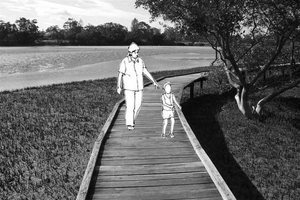 Boardwalk
 -
 Boardwalk with resting area


C.3 From Theory of Change to Implementation
- For implementing your vision: Which partnerships are needed? Which governance model is required?
- Who needs to act and how? Draw and explain a change/process model/timeline
- Which resources are needed? On which assets can you build?
Project process requires the action of different stakeholders together. The general framework is given by supra parties such as the government (laws) and Natura 2000 (guidelines). In our case, Tallinn City has a leading role in establishing rules, but also as an actor in the process. Its allies are the investors and the real estate developers, they bring financial feasibility to the project. Also, the developers are responsible for the housing development part of the project on the east coast. But one category of stakeholders should not be forgotten: the influences. The public should participate and should be consulted at every step of the process. The preservation of the nature reserve is their priority.
-
 Governance model and stakeholders involved

We have drawn priorities about which actions should be first. We divided the construction process into 3 phases, preceded by a phase of reflection and conception. The biggest problem is the accessibility to the beach. Indeed, in summer the parking areas are totally saturated and people are parking wildly along the street. The street is already not appealing to walk along for pedestrians but then it becomes even more difficult. We want to give more possibilities to go to the beach with the extension of the tramway line and the reduction of car traffic. Also, the sale of port plots to real estate developers is already ongoing. In the meantime, the green corridors and buffer zones welcome new trees because they will take time to establish their structure. Then a second phase would consist in rehabilitating the grey parkings into green areas with trees and shrubs to provide shadow and reduce impervious surfaces. Also, new trails should be built in the reserve to diversify the trails and target a larger public. Last but not least, once the sale of port plots completed, the construction of the new sustainable neighborhood can begin. In the last phase, the construction of the access on the west coast starts, it was not a priority, as a path is already existing. Another big part of the project is the promenade. It is an expensive operation that is why it is at the end (it needs funds raised by the real estate operation). Also, it will be easier to construct the promenade once the sustainable neighborhood is built and inhabited.
-
 Timeline of the project

![[1]](https://commons.wikimedia.org/wiki/File:Mellin_Atlas_von_Lieffland_Tallinn.png)
![[3]](https://commons.wikimedia.org/wiki/File:Paljassaare_hoiuala._01.jpg)
![[4]](https://commons.wikimedia.org/wiki/File:Paljassaare_laht_2010-07-14.jpg)
C.4 References
[48] Google maps : https://www.google.fr/maps/@59.473895,24.7030839,3198m/data=!3m1!1e3
[49] Icons from Noun Project : https://thenounproject.com
[50] Tallinn City website : https://www.tallinn.ee/eng/
[51] Maaamet : http://xgis.maaamet.ee/maps/XGis?app_id=UU82A&user_id=at&LANG=2&WIDTH=1338&HEIGHT=809&zlevel=6,541254.28771977,6593020.8282471
D. Process Reflection
"We believe that the case study in general is a very good method and a useful tool. The structure of the course was good with the materials and the lectures and progressive, it helped us and strengthen our knowledge in spatial planning. We obtained many outcomes like the fact of learning how to develop methods for comprehensive planning process especially in the local level and how we came across many technical and practical municipal comprehensive planning. We encountered some limitations through the phases, one of the difficulties we faced is the fact that we have no locals in our group which we had some difficulties in understanding some Estonian documents, in addition the area was large (360 ha) and very complex because of the diversity of functions, the different kinds of landscapes (Harbor, natural area, industrial area, abandoned areas, beach, wetland…) and the fact that the study area was and is still changing and developing rapidly. It was interesting to work in a diverse group with different backgrounds, cultures and methods. It was beneficial in the work process and in the brain-storming. And for the next time we would try harder to get more feedback and more time for consultations."