Case Study B.2: Rione Terra-Potus Julius: Difference between revisions
| (236 intermediate revisions by 8 users not shown) | |||
| Line 15: | Line 15: | ||
| '''Country''' || style="background:Lavender"|''Italy'' | | '''Country''' || style="background:Lavender"|''Italy'' | ||
|- | |- | ||
| '''Topics''' || style="background:Lavender"|'' | | '''Topics''' || style="background:Lavender"|'' Landscape System Analysis,Landscape Evaluation and Assessment,Strategy and Master Plan'' | ||
|- | |- | ||
| '''Author(s)''' || style="background:Lavender"|''Adam Mihaela,Abhishek Passan,Francesca Lucido | | '''Author(s)''' || style="background:Lavender"|''Adam Mihaela, Abhishek Passan, Francesca Lucido, Jlenia Graziuso, Kazi Zayed, Maria Nuciu, Maria Alexandra Ivănescu, Monica-Gabriela Amuza, | ||
'' | '' | ||
|- | |- | ||
| colspan="3" align="center" style="background:silver"| [[File: | | colspan="3" align="center" style="background:silver"| [[File:C_CARELLI.jpg|400px]] | ||
|- | |- | ||
| ||style="background:Lavender"| | | ||style="background:Lavender"| | ||
| Line 28: | Line 28: | ||
= Rationale = | = Rationale = | ||
*'' | |||
*'' | * The '''Rione Terra''' quarter represents the '''multilayered historic city''' of Pozzuoli, the heart of the city and its '''ancient acropolis''', and it was founded by the '''Romans''' in the 2nd century B.C. | ||
* Rione Terra has been a place of several historical and natural events which brought important changes in the morphology of the Phlegraean Fields, preserving the memory of the past centuries. | |||
* Access to the '''Mediterranean Sea''' and the presence of the '''Gauro Mountain''' compose the beautiful landscape of this area and favors '''historical and recreational tourism'''. | |||
* The volcanic terrain of the area generated '''fertile soil'''. This aspect holds great '''agricultural potential'''. | |||
* Taking into account the challenges of the area, this impact can put pressure on the natural environment and onto the cultural heritage, to meet the needs of the growing population. | |||
= Location and scope = | = Location and scope = | ||
''You can edit this map with the [[Special:MapEditor|map editor]]'' | ''You can edit this map with the [[Special:MapEditor|map editor]]'' | ||
{{#display_map: | {{#display_map: 40.822453,14.121529~Mangalia~Location of our Intensive Study Programme | ||
}} | }} | ||
| Line 40: | Line 48: | ||
== A.1 Landscape layers and their system context == | == A.1 Landscape layers and their system context == | ||
Rione Terra is located in the Province of Naples (Italy). From a geomorphologic point of view, the region is characterized by a | === Geomorphology, landscape units and coastal typology === | ||
Rione Terra is located in the Province of Naples (Italy)(fig.1). | |||
From a geomorphologic point of view, the region is characterized by a '''graben-like depression'''.The depression floors are composed by '''broad alluvional plains'''. | |||
As a consequence of the '''tectonics present''' in this area, after a period of tectonic calm that allowed a mature '''erosional landscape''' to develop across the litho-structural complex (in Early Miocene to Middle Pliocene.)(fig.2,fig.3) | |||
<gallery caption=" " widths="200px" heights="150px" perrow="5"> | <gallery caption=" " widths="200px" heights="150px" perrow="5"> | ||
File:1.png|''Fig. | Harta_administrativ-teritoriala.png|''Fig.1:Administrative-territorial location of Naples - Rione Terra | ||
File:1.png|''Fig.2:The outcrops of lower and middle plistocene marine deposits. | |||
File:Rt.png#file|''Fig. | File:Rt.png#file|''Fig.3:The geological and geomorphological records left in the area by lower and middle pleistocenic events. | ||
</gallery> | </gallery> | ||
=== Land use === | === Land use === | ||
Napoli, being part of Italy, has undergone numerous changes over time. At present, the settlements have remained since ancient times, having numerous '''medieval monuments, castles,''' as well as ruins. (fig.4) The underground archaeological '''Rione Terra''' is a journey in the ancient Roman colony, Puteoli, was founded in 194 BC and soon became a '''commercial port'''. | |||
The course is located below the tuff rock overlooking the Gulf of Pozzuoli, between Nisida and Bay, and runs along the principal axes of the Roman city, | |||
The course is located below the tuff rock overlooking the Gulf of Pozzuoli, between Nisida and Bay, and runs along the principal axes of the Roman city, cardo and decumani. | |||
Archaeologists have excavated and restored a four thousand square metre area of the ancient Roman acropolis and its entire underground urban fabric. Now it can be seen the two main arteries of the acropolis flanked by millers’ shops, ancient taverns and the houses of fishermen. | Today, '''beneath Rione Terra''', there lies a '''virtually untouched Roman town'''. | ||
Archaeologists have excavated and '''restored''' a '''four thousand square metre area''' of the ancient '''Roman acropolis''' and its entire underground urban fabric. Now it can be seen the '''two main arteries of the acropolis''' flanked by '''millers’ shops, ancient taverns''' and the '''houses of fishermen.''' | |||
Due to '''volcanic eruptions''', the area became '''very fertile''' because of the '''lava minerals'''. Agriculture is based on grapes, tomatoes, lemons exotic fruits and native capers. (fig.5) | |||
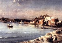
From the infrastructure point of view, Napoli owns an airport, train lines across the city, buses. Being '''a port city''', transportation can also be done on water. (fig.6) | |||
<gallery caption=" " widths="200px" heights="150px" perrow="5"> | <gallery caption=" " widths="200px" heights="150px" perrow="5"> | ||
Rione_Terra_acient_ruin.jpeg|''Fig. | Rione_Terra_acient_ruin.jpeg|''Fig.4:Rione Terra-Ancient ruin'' | ||
Naplescor.jpg|''Fig. | Naplescor.jpg|''Fig.5: Land use'' | ||
Naples2.jpg|''Fig. | Naples2.jpg|''Fig.6: Infrastructure'' | ||
</gallery> | </gallery> | ||
=== Green/ | === Green/Blue infrastructure === | ||
The studied area has a high potential of development regarding green-blue infrastructure due to the dominant presence in the territory of the Gauro Mountain but also for the | The studied area has a high potential of development regarding green-blue infrastructure due to the dominant presence in the territory of the '''Gauro Mountain''' but also for the access to the '''Mediterranean Sea'''. | ||
Gauro Mountain is the volcanic formation with the highest pick it’s a part of the Regional Park situated in the Phlegraean Fields. This area is very important for the ecosystem and it’s also a protected area part of the Natura 2000 Network. The mountain is an identity element for this zone, with flora and fauna specific for this type of territory and | '''Gauro Mountain''' is the volcanic formation with the '''highest pick''' it’s a part of the Regional Park situated in the '''Phlegraean Fields'''. This area is very important for the ecosystem and it’s also a protected area part of the '''Natura 2000 Network'''. | ||
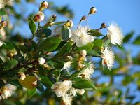
The mountain is an identity element for this zone, with flora and fauna specific for this type of territory and characterized by thick Mediterranean vegetation like chestnut in the north side and plants like '''cistus'''[https://it.wikipedia.org/wiki/Cistus], '''mastic trees'''[https://it.wikipedia.org/wiki/Pistacia_lentiscus] and '''myrtle'''[https://it.wikipedia.org/wiki/Myrtus_communis] in the steep west side. Also, in the past, in the neighborhood territory of the mountain, was cultivated vines, '''valuable agriculture areas''' nowadays. | |||
This important elements of green-blue infrastructure are in a continually changing because of the '''human intervention''' and also the '''urbanization''' causing in more cases '''pollution of the environment'''. We can see this urban development also in the crater of the Mount Gauro, where now is the Carney Park- a recreational facility of the US Navy that can't be visited by other users different of the US Navy stuff. So, because of this limitation, the landscape in this part, from the top of the mountain is not valued as it should be. | |||
'''Natura 2000 Network''' prevents this type of intervention in the '''green protected area''', and by '''improving the green-blue infrastructure''' in a '''sustainable manner''', the ecosystem will be protected better(marine and mountain biodiversity), reaching a '''sustainable development of the local economy''' and also of the urbanization. | |||
<gallery caption=" " widths="200px" heights="150px" perrow="5"> | <gallery caption=" " widths="200px" heights="150px" perrow="5"> | ||
Green-Blue Infrastructure.jpg|''Green-Blue Infrastructure'' | |||
Gauro Mountain_opt.jpg|''Gauro Mountain'' | |||
Portus Julius.jpg|''Portus Julius'' | |||
Pozzuoli Port.jpg|''Pozzuoli Port'' | |||
Top of Gauro Mountain opt.jpg|''Top of Gauro Mountain'' | |||
Mastic tree.jpg|''Mastic tree'' | |||
Myrtle.jpg|''Myrtle'' | |||
Cistus.jpg| ''Cistus'' | |||
</gallery> | </gallery> | ||
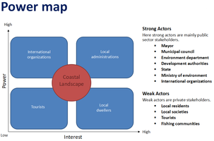
=== Actors and stakeholders === | === Actors and stakeholders === | ||
Strong Actors in the Rione Terra-Potus Julius area: Mayor, Municipal council, Environment department, Development authorities, State, Ministry of the environment, International organizations. | |||
Weak actors: Local residents, Local societies, Tourists, Fishing communities. | |||
Here, '''International organizations have higher authority''' and they have the liabilities most. | |||
'''Local authorities''' have high power and '''gets affected more''' because of the locality. | |||
Local dwellers contain less power but have the highest interest and effect. | |||
Tourists have less power and have less stake or effect. | |||
<gallery caption=" " widths="500px" heights="200px" perrow="5"> | <gallery caption=" " widths="500px" heights="200px" perrow="5"> | ||
File: | File:Power_map_rionneterra.png|''Rione Terra powermap'' | ||
</gallery> | </gallery> | ||
=== Sacred spaces and heritage === | === Sacred spaces and heritage === | ||
The Rione Terra quarter represents the multilayered historic city of Pozzuoli, the heart of the city and its ancient acropolis, and it was founded by the Romans in the 2nd century B.C. The stratifications and the layers are visible, but under the level of the contemporary city. Following restoration and redevelopment of both the Rione and the archaeological itinerary underlying from the Roman era, from 2014 it was opened to the public. | |||
* '' | |||
'''''Which places/elements hold cultural value and to whom?''''' | |||
Rione Terra, being a multilayered historic area, features many well-preserved heritage sites. They hold great value to the locals because they represent the entire history and identity of this culture. They also hold value to the tourists, which are mainly attracted to these beautiful wonders of the past, integrated into the present atmosphere of the city. | |||
* '''Pozzuoli Cathedral''' or the '''Basilica of San Procolo Martire''' is the main Roman Catholic church in Pozzuoli. The church was first housed in a former Roman temple, the '''Temple of Augustus''' built by the rich merchant Lucius Calpurnius. Accelerated bradyseism in 1983-1984 led to the monument being totally abandoned in 1992, leading to vandalism and looting. Finally, the Regione Campania launched an architectural competition for the restoration in July 2003. In the entrance façade, a glass portal reconstructs the colonnade pronaos of the temple; from here, passing by the cell, in which it is possible to see the cuts made in the columns for building the church, the visitor meets the apse part of the Baroque era; the lights in the ceiling recreate the constellations visible in the sky when Saint Paul the Apostle landed in Pozzuoli in 61 AD. Restoration works have respected the marks of the time, keeping them visible, in order to identify the passages from the Roman era to the Renaissance-Baroque, returning to the city a cathedral a little bit different from how it was, but of great impact and deep in history. | |||
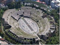
* '''The Flavian Amphitheater''' is the third largest Roman amphitheater in Italy and it is sharing its name with the most famous of the Roman structures. It was likely built by the same architects who previously constructed the Roman Colosseum and it gives a unique and arguably deeper look into the world of Roman spectacle and gladiatorial combat. In 305, the arena was the setting for the persecutions of the patron of Pozzuoli, Saint Proculus, and the patron saint of Naples, Saint Januarius. Visitors can also go beneath the arena to explore the underground complex below the surface and, in doing so, get a sense of how the amphitheater operated in antiquity. | |||
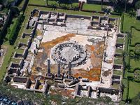
* '''Macellum of Pozzuoli''' was the macellum or market building of the Roman colony of Pozzuoli. When first excavated in the 18th century, the discovery of a statue of Serapis led to the building being misidentified as the city's serapeum or Temple of Serapis. The three standing marble columns indicated that these columns had remained upright over centuries while the site sank below sea level, then re-emerged. This puzzling feature was the subject of debate in early geology and eventually led to the identification of bradyseism in the area, showing that the Earth's crust could be subject to gradual movement without destructive earthquakes. | |||
* '''The necropolis of San Vito''', so-called due to the proximity of one small church dedicated to Saint Vito, is today a forgotten complex, in some ways abandoned and open to a few scholars. | |||
* '''Necropoli di Via Celle''' stands out among other necropolis for its majesty. After Rome, Pozzuoli is the city in the world that contains the greatest number of funerary monuments from the Roman era. Like most streets on the outskirts of Roman cities, it was lined with burial grounds, so the Necropolis of Via Celle is undoubtedly the most majestic "cemetery" of the Roman era. | |||
* '''Stadio di Antonino Pio''', unearthed in 2008, was built by emperor Antoninus Pius in honor of the Hellenic spirit of his predecessor Hadrian. The building is located near one of the villas of Cicero, where Adriano was buried after his death in Baia in 138 A. D. This Stadium, hosted a sort of Olympic-type sport event that occurred every five years known by the Greek name of Eusebeia. The stadium was located on via Domitiana (today via Luciano) where it can be admired to this day in all its grandeur. The entire area was buried following the eruption of Monte Nuovo of 1538 while some parts were incorporated in a farmhouse in the 19th century. The modern via Domiziana has cut lengthwise this historical artifact compromising its unity. | |||
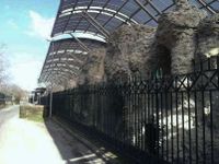
* '''Temple of Neptune''': Similarly to Baia, Pozzuoli was famous for its thermal baths with the most famous one being the so-called Temple of Neptune where well-preserved remains can be visited today not far from the Anfiteatro Flavio. The walls were part of the frigidarium, also known as the cold environment while the rear portion of this structure was enriched with a central apse adorned by niches and arches. The rooms arranged on the sides had vaulted ceilings or barrel vaults. The thermal complex must have appeared as an impressive building, visible from the sea, built in the 2nd century A.D. and used until the fourth century A.D. | |||
<gallery caption=" " widths="200px" heights="150px" perrow="5"> | <gallery caption=" " widths="200px" heights="150px" perrow="5"> | ||
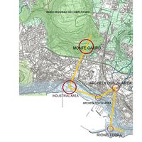
File: | File:heritage rione terra1.jpg|''Map of heritage sites'' | ||
File: | File:Cathedral of Pozzuoli.jpg|''Cathedral of Pozzuoli'' | ||
File: | File:Anfiteatro Flavio.jpg|''Anfiteatro Flavio'' | ||
File:Macellum of Pozzuoli, Temple of Serapis.jpg|''Macellum of Pozzuoli'' | |||
File:Necropoli di S. Vito.jpg|''Necropoli di San Vito'' | |||
File:Necropoli di Via Celle.jpg|''Necropoli di Via Celle'' | |||
File:Stadio di Antonino Pio1.jpg|''Stadio di Antonino Pio'' | |||
File:Temple of Neptune.jpg|''Temple of Neptune'' | |||
</gallery> | </gallery> | ||
=== Visual appearance and landscape narrative === | === Visual appearance and landscape narrative === | ||
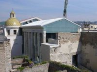
'''Rione Terra''' is the '''first settlement of Pozzuoli'''. It is placed on a hill, which stands 33 m from the sea. Its position has always been positive to control the arrival of the enemies from the sea and from the land. Unfortunately, due to bradyseisms and especially the earthquake in 1984, Rione Terra was the subject of a great work of retraining and restoration. | |||
Finally, it was opened in 2014. | |||
Today, this area is very interesting to visit because it is a really '''overlapping of housing layers.''' | |||
Through the years, many important people had been inspired by this place. | |||
A great example, which is able to summarise the essence, is Alberto Angela's quote. | |||
The Italian paleontologist tells:''There is a neighborhood where chapters of Pozzuoli's long history are overlapped like the pages of a book.'' | |||
While, between VIII and IX century A.D., there are some lines written in the Acts of St. Peter and Paul, from the apocryphal Gospel, they justified the sinking of the city to a miracle. It was operated by the apostle Paolo to punish the city where was executed the master of the ship, whit which the saint arrived from Orient. | |||
Moreover, also the geographer Strabone, explains his thoughts about. He considered the '''fortress as the landing of the exiles of the island of Samo''', who founded ''Dicearchia'', the government of the correct ones. | |||
Thanks to its suggestive character this area has been also the subject of lots of paintings. | |||
In 1764 G.P.Bollori re-made a painting, which was lost. This one showed the port area and that right there was a '''temple dedicated to Apollo,''' it was '''located on the first acropolis of Pozzuoli'''. | |||
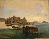
There are also other views from the nineteenth century, made by Franz Ludwig(1830) and the canvas made by Consalvo Carelli. | |||
<gallery caption=" " widths="200px" heights="150px" perrow="5"> | <gallery caption=" " widths="200px" heights="150px" perrow="5"> | ||
G_P_BOLLORI.jpg|''Painting by Bollori of Rione Terra in 1764'' | |||
F_LUDWIG.jpg|''View of Rione Terra by Franz Ludwig in 1830'' | |||
C_CARELLI.jpg|''Oil on canvas by Consalvo Carelli from the 19th century'' | |||
Mountain.jpg| ''The Crater of Monte Gauro by William Hamilton 1776'' | |||
</gallery> | </gallery> | ||
== A.2 Summary of you landscape system analysis and your development Targets == | == A.2 Summary of you landscape system analysis and your development Targets == | ||
'''Landscape System Analysis - DPSI(R) diagram''' | |||
<gallery caption=" " widths="500px" heights="200px" perrow="5"> | <gallery caption=" " widths="500px" heights="200px" perrow="5"> | ||
File: | File:DPSIR Rionne Terra.jpg|''Rione Terra's driving forces are its heritage, the landscape, and tourism that happens because of it. This creates a great base for economic growth. These driving forces obviously create pressures on the area and so the worst felt effects are mass tourism, urban sprawl, and pollution. This impacts some of the Sustainable Development Goals, such as: 11. Sustainable Cities and Communities, 13. Climate Action, 14. Life Below Water, 3. Good health and well-being, Affordable and Clean Energy, Life on Land. There are then two types of impact on the landscape: a negative one, and a positive one. The negative impact is causing the disturbance of the landscape, pollution of air, water and soil, economic exploitation, and the start of one chaotic urbanization and possible damage to the heritage. On the other hand, there are positive effects such as: the conservation and restoration of the cultural heritage, the possible economic growth that happens because of tourism and global interest for Rione Terra.'' | ||
</gallery> | </gallery> | ||
'''Landscape hypothesis''' | |||
<gallery caption=" " widths="500px" heights="200px" perrow="5"> | <gallery caption=" " widths="500px" heights="200px" perrow="5"> | ||
File: | File:Scenario.jpg|''Our hypothesis is that the unsustainable growth and chaotic urbanization are the causes for pollution, destruction of the natural heritage and loss of biodiversity which also leads to a low quality of life. The answer for solving the problems in this scenario is a sustainable development using alternative energy, nature-based sustainable solutions and planfication for the urban development. We thought that other solutions for the problems are to protect nature and the cultural heritage by preserving and restoring it. Also, near the mountain, because of lava minerals from the volcanic eruptions, the soil here is very fertile, and the land has agricultural potential, so we can use this potential in our future development strategy.'' | ||
</gallery> | </gallery> | ||
== A.3 Theory reflection == | == A.3 Theory reflection == | ||
Plans and policies play a crucial role in understanding the various concepts related to conserving and formulating landscapes. They are not just guiding the users, but also the competent authorities to safeguard the same. Discussing policies at International, European and local level are as followed: | |||
At the International level, the '''UN HABITAT Planner for Climate Change''' plays a crucial role in developing the guidelines for the policy that highlights the impact of climate change, at a global and unprecedented scale. It embarks the causes of pollution and how to integrate global measures for the same as an integral part of planning. It is to be applied at different scales, climate-friendly built environment and introducing concepts like participatory planning, green infrastructure, etc. | |||
The second policy or the European policy to be considered is the '''European Landscape Convention (Florence, 2000)''' which very basically defines the landscape and the policy as two dependent entities reforming the whole structure of landscape as one. It establishes the concept of human beings at the center of the system thus identifying landscapes and how to protect them. | |||
The third local level policy is the '''Integrated Coastal Zone Management''' plan in Italy, in which the plan describes the gap between the scientific community and the people responsible for the formulation of plans, thus depicting the loose control at a national level, thus leaving the regional and lo authorities unguided. It is an interlinked system incorporating all from the stakeholders to the users, thus all these policies should be interlinked.'' | |||
== A.4 References == | == A.4 References == | ||
[1]https://www.researchgate.net/profile/Antonio_Santo2/publication/258513279_Geomorphology_and_neotectonic_evolution_of_a_sector_of_the_Tyrrhenian_flank_of_the_Southern_Apennines_Region_of_Naples_Italy/links/0deec529093c63b31d000000/Geomorphology-and-neotectonic-evolution-of-a-sector-of-the-Tyrrhenian-flank-of-the-Southern-Apennines-Region-of-Naples-Italy.pdf (text+fig.2,fig.3) | |||
1 | |||
[2] http://www.napolike.com/tourism/place/district-earth-pozzuoli-napoli/ | |||
[3] http://www.pressreader.com | |||
[4] https://www.likealocalguide.com/naples/rione-terra(fig.4) | |||
[5] https://www.flickr.com/groups/napolinobilissima/discuss/72157633306343537/#comment72157635169401115 | |||
[6] https://it.wikipedia.org/wiki/Monte_Gauro | |||
[7] http://www.naplesldm.com/gauro.php | |||
[8] Geotechnics and Heritage: Case Histories | |||
[9] http://www.rioneterrapozzuoli.com | |||
[10] http://www.pafleg.it/it/1/home | |||
[11] https://izi.travel/en/italy/city-guides-in-campania-pozzuoli | |||
= Phase B: Landscape Evaluation and Assessment = | = Phase B: Landscape Evaluation and Assessment = | ||
== B.1 Assessment Strategy == | == B.1 Assessment Strategy == | ||
* | |||
* | |||
Based on the hypothesis derived from our previous landscape system analysis, we defined some goals that try to gradually improve the status of this area, by using its strengths to deal with the weaknesses. | |||
Our goals are trying to improve the status of tourism, transport infrastructure and of the coastal landscape. We also try to avoid the chaotic development caused by the lack of plannification and uncontrolled tourism. | |||
Therefore, our goals are: | |||
*To create a coherent system that connects the green and blue infrastructure, the heritage and the existing viewpoints that reveal the beautiful landscape. | |||
*To reconnect the city with the harbor/coastal landscape by increasing its attractiveness. | |||
*Smart use of the land. What can we build there? | |||
*Improve transport infrastructure for better accessibility. | |||
*Controlled tourism: What does it mean? How can we do that? | |||
== B.2 Mapping == | == B.2 Mapping == | ||
<gallery caption=" " widths="500px" heights="200px" perrow="1"> | <gallery caption=" " widths="500px" heights="200px" perrow="1"> | ||
File: | File:green1.jpg|''Green-blue infrastructure: Besides the public parks of the area and Monte Gauro, we found that our area has a great deal of agriculture land, a strong agricultural presence, and a starting point for agro-tourism. There are also some heritage sites that can be integrated into the green system, because they are mostly covered in vegetation. We envision a route that can link all the green spaces into a coherent system. '' | ||
File: | File:Mapping of potential public spaces Rionne Terra.jpg|''Mapping of potential public spaces in Rionne Terra: The Rione Terra quarter represents the multilayered historic city of Pozzuoli, the heart of the city and its ancient acropolis. There are many heritage sites that have been preserved, in either good or poor condition. At the same time, there are also some plazas where people can find monuments and statues, plazas that hold a certain meaning to the people and that are located in close proximity to the heritage sites. Two of these squares are also located along the harbor area, and they reveal beautiful viewpoint and scenery. We found that many of these places are either abandoned, not well kept, not used to their maximum potential or even turned into parking spaces. Some are not accessible to the public, or lack attractiveness. Some heritage sites, such as the Temple of Neptune, present a great deal of vegetation, so they can be integrated into parks or other kind of green public spaces, even memorial public spaces. They can become great losir places for the people of the city and great touristic attractions, if they are integrated into a green system.'' | ||
File: | File:green 1.jpg|''Areas that can go through functional conversion: In this case, our mapping reveals problems related to the land-use in the area. The lack of planification created areas with empty land and some poor placement of urban functions, such as the industry that disrupts the flow of the living areas. We found some areas that can be turned into green spaces, some with great viewpoints to the landscape, on the top of Monte Gauro. Meanwhile, we also marked the industrial area of the harbor which can cause a great deal of pollution to the water and coastal landscape. The water bank is not well taken care of and it would be a great place for a promenade.'' | ||
</gallery> | </gallery> | ||
== B.3 Problem definition and priority setting == | == B.3 Problem definition and priority setting == | ||
'''*Give a summary of the major findings of your mapping process, what are the problems/potentials identified?''' | |||
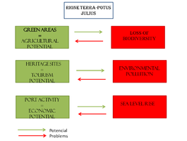
The Rione Terra study area presents a few distinct elements that can greatly enhance its development. First of all, we have identified an existing agrarian landscape and heritage, that can greatly boost the economy. What is more, besides the coastal landscape and Monte Gauro, the area consists of many green spaces, that are unfortunately not very well connected which leads to underutilization of the resources available. | |||
Secondly, the Rione Terra study area is a potentially high area for the economy because of its cultural heritage, having many heritage sites and sacred places that have been preserved. To link this to the first mapping, we found out that many of these sites are nearby urban plazas that are not very well kept. Some are not accessible to the public, or lack attractiveness. Some heritage sites, such as the Temple of Neptune, present a great deal of vegetation, so they can be integrated into parks or other kinds of green public spaces, even memorial public spaces. They can become great losir places for the people of the city and great touristic attractions if they are integrated into a green system. | |||
These findings can, in fact, enhance the economy of this area through historical tourism and agriculture or even agro-tourism. Of course, tourism needs to be controlled because it can damage the heritage sites and can greatly pollute the area. | |||
The third part of the mapping leads us to understand the need for functional conversion in some areas. Some areas of great importance get developed much faster as compared to the others. The positive outcome could be re-establishing these structures into some green spaces or connection nodes to the bigger structure thus enhancing the functional and aesthetical value of the area and improving the overall standards for the city. | |||
The industrial area of the harbor which can cause a great deal of pollution to the water, can affect the green and blue landscape, because it is downgrading its attractivity. | |||
To summarize: | |||
One potential risk that we have found it's given by the potential for sea level growth that can jeopardize both port activities and the population. Another risk comes from the exploitation of green land, so a possible negative effect may be the loss of biodiversity caused by pollution. Becoming a very popular area for historical tourism, the increasing the number of tourists may be a negative effect on the environment as well as the resources of the area. | |||
<gallery caption=" " widths="500px" heights="200px" perrow="5"> | <gallery caption=" " widths="500px" heights="200px" perrow="5"> | ||
File: | File:Harta R P.png|''Potentials/risks diagram | ||
</gallery> | </gallery> | ||
'''*Set priorities for the most relevant issues:''' | |||
The priorities for our most relevant issues presented in the scheme above can be: | |||
*valorization of the agricultural areas in a sustainable way by linking them into a green-blue system and developing agro-turism | |||
*reducing environment pollution by converting the industrial areas form the port that pollute the air and also the water into light industry less polluting | |||
*economic sustainable development by value the port activity and also turism | |||
== B.4 Theory reflection == | == B.4 Theory reflection == | ||
To evaluate the complex area of the Rione Terra the methods considered were different: after studying the historical aspect and observing the area through google maps, the group chose some important methods that had been able to realize some aspects. | |||
The '''Landscape & Visual Impact Assessment (LVIA)''' method: this method helps us to understand the effects of new landscape ideas. By creating a continuous line and reopening many public areas of the terrestrial district (now still closed) the negative effects of the landscape can be reduced or avoided. | |||
Another method is the '''Blue Health Environmental assessment tool (BEAT)''', it helped us understand the impact that exposure to the sea has on the people who live there and on tourists. | |||
These methods have a positive correspondence, because they are responsible for increasing tourism, reducing stress for users thanks to the proximity of the sea. | |||
Furthermore, another method used was '''Ecosystem Services (ES)'''. The last one gives us the possibility to study the naturalistic value of the area. This type of evaluation defines different aspects of the site, through the definition of heterogeneous factors of the Rione Terra system. Including both the risks to the health of ecosystems and the potential to provide a service. | |||
== B.5 References == | == B.5 References == | ||
* ''give a full list of the references you have used for this section'' | * ''give a full list of the references you have used for this section'' | ||
1. https://bradisismoflegreo.files.wordpress.com/2013/01/pozzuoli-convegno-dalla-rinascita-della-cattedrale-a-valoriz-rione-t.pdf?fbclid=IwAR1qWtF1pvkxRf4jIpubDLL8D-1AlmHvQBiI1WG33MmhxYbb1eSLl0OLpFY | |||
=Phase C – Strategy and Master Plan = | =Phase C – Strategy and Master Plan = | ||
== C.1 Goal Setting == | == C.1 Goal Setting == | ||
The coastal area of the results of the Rione Terra and Portus julio evaluation has led to five objectives that aim at sustainable local regeneration. According to the studies carried out, five strategic planning objectives have been designed. | |||
-'''To increase public transport lines and limited traffic areas, the aim is to reduce pollution.''' This objective is linked to objective 3: to ensure health and well-being for all and for all ages, and to objective 11: Making cities inclusive, safe, resilient and sustainable. | |||
-'''Investing in sustainable industries and innovative development technologies.''' in fact, in the port area, there is the greatest number of human activities; moreover, there is a reduced amount of vegetation, which could prevent the collapse of the ridge, and there is most of the illegal constructions that undermine its integrity instead. This objective is linked to objective 9: building resistant infrastructure, promoting sustainable industrialization and innovation. | |||
-'''Focus on sustainable economy, such as tourism and the fish market.''' This objective is linked to objective 8: Promote lasting, inclusive and sustainable economic growth, full and productive employment and decent work for all. | |||
-Other is '''the protection of the cultural and natural heritage''' and '''the reduction of pollution and the increase in the ecological network'''. These objectives are linked to objective 14: conserving and sustainably using the oceans, seas and marine resources and objective 15: sustainable management of forests, combating desertification, halting and reversing land degradation, but also with objective 12: Guaranteeing sustainable consumption and production models | |||
[[File:Goalsetting.jpg|400px]]| | |||
''Goal setting'' | |||
== C.2 Spatial Strategy and Transect == | == C.2 Spatial Strategy and Transect == | ||
The intervention focuses on those that are fundamental elements received from the analysis. | |||
Attention to cultural heritage, attention to connections with the attraction of the landscape and attention to human well-being. | |||
identifying those that are critical points, we went to work creating links that took into account (especially in the industrial area) the fragmentation of the area, going to rejoin it. | |||
We have created links (the green ones) that go to mend '' sea and land ''. | |||
Through purely pedestrian paths made of broad points of view. | |||
With gray, we have highlighted the inclusion of a cycle path that runs alongside the coast. | |||
To give the coast back to the citizens we have worked considering a band as uniquely destined for the passage and the free vision of the landscape. | |||
However, as far as buildings are concerned, the intent is not to eliminate them completely, but to create a multifunctional pole with an L shape. | |||
And two other elements intended for catering and overnight stays respectively. | |||
The intent of this project is to give the sea back to those who live in this area rich in history and life. | |||
<gallery caption=" " widths="500px" heights="200px" perrow="1"> | <gallery caption=" " widths="500px" heights="200px" perrow="1"> | ||
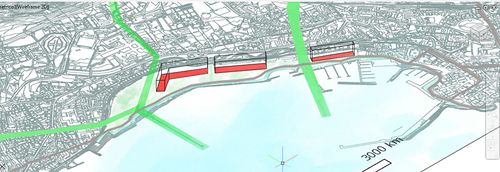
File: | File:TransectRioneterra.jpg|''add caption here''|''TRANSECT'' | ||
File: | File:Ourvision1.jpg| | ||
File: | File:Ourvision2.jpg|''OUR VISION'' | ||
File: | File:Visione1.jpg| | ||
</gallery> | </gallery> | ||
== C.3 From Theory of Change to Implementation == | == C.3 From Theory of Change to Implementation == | ||
According to the goals of the project we have developed our own in order to improve the quality of its inhabitants and visitors. Our area was initially a large industry, so it was necessary to restore and reclaim the industry to regrow cleanly. As support for these new activities, infrastructures must be upgraded to ensure the flow from neighboring municipalities, reduce traffic and pollution and develop the interest of private investors in commercial activities and tourism attractors. A new clean network would allow the whole area to be accessible to citizens and foreigners. At the moment this area has a great potential. For all these reasons, we hope to fulfill the prefixed objectives of the sustainable development. | |||
<gallery caption=" " widths="500px" heights="200px" perrow="1"> | <gallery caption=" " widths="500px" heights="200px" perrow="1"> | ||
File: | File:Ourgovernancemodel.jpg|''Governance model'' | ||
File: | File:Processtimeline1.jpg|''Process timeline'' | ||
</gallery> | </gallery> | ||
| Line 203: | Line 352: | ||
= D. Process Reflection = | = D. Process Reflection = | ||
This experience has taught us many things, working in a group of people of different nationalities, having self-control to present in a language different from ours, but above all we have got to know our territory better and make it known also to non-Italian students. | |||
thanks for everything. | |||
[[File:Processreflection1.jpg]] | |||
---- | ---- | ||
[[Category:Coastal Landscapes Case Study 2019]] | [[Category:Coastal Landscapes Case Study 2019]] | ||
[[Category:Coastal Landscapes Case Study]] | [[Category:Coastal Landscapes Case Study]] | ||
Latest revision as of 05:12, 15 June 2019
>>>back to working groups overview
| Area | Case Study B.2: Rione Terra-Potus Julius | |
| Place | Rione Terra-Potus Julius | |
| Country | Italy | |
| Topics | Landscape System Analysis,Landscape Evaluation and Assessment,Strategy and Master Plan | |
| Author(s) | Adam Mihaela, Abhishek Passan, Francesca Lucido, Jlenia Graziuso, Kazi Zayed, Maria Nuciu, Maria Alexandra Ivănescu, Monica-Gabriela Amuza,
| |

| ||
Rationale
- The Rione Terra quarter represents the multilayered historic city of Pozzuoli, the heart of the city and its ancient acropolis, and it was founded by the Romans in the 2nd century B.C.
- Rione Terra has been a place of several historical and natural events which brought important changes in the morphology of the Phlegraean Fields, preserving the memory of the past centuries.
- Access to the Mediterranean Sea and the presence of the Gauro Mountain compose the beautiful landscape of this area and favors historical and recreational tourism.
- The volcanic terrain of the area generated fertile soil. This aspect holds great agricultural potential.
- Taking into account the challenges of the area, this impact can put pressure on the natural environment and onto the cultural heritage, to meet the needs of the growing population.
Location and scope
You can edit this map with the map editor
A Landscape System Analysis
A.1 Landscape layers and their system context
Geomorphology, landscape units and coastal typology
Rione Terra is located in the Province of Naples (Italy)(fig.1).
From a geomorphologic point of view, the region is characterized by a graben-like depression.The depression floors are composed by broad alluvional plains.
As a consequence of the tectonics present in this area, after a period of tectonic calm that allowed a mature erosional landscape to develop across the litho-structural complex (in Early Miocene to Middle Pliocene.)(fig.2,fig.3)
-
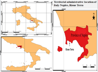 Fig.1:Administrative-territorial location of Naples - Rione Terra
 -
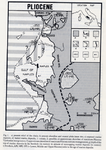 Fig.2:The outcrops of lower and middle plistocene marine deposits.
 -
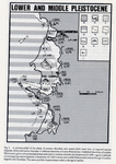 Fig.3:The geological and geomorphological records left in the area by lower and middle pleistocenic events.


Land use
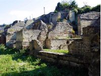
Napoli, being part of Italy, has undergone numerous changes over time. At present, the settlements have remained since ancient times, having numerous medieval monuments, castles, as well as ruins. (fig.4) The underground archaeological Rione Terra is a journey in the ancient Roman colony, Puteoli, was founded in 194 BC and soon became a commercial port.
The course is located below the tuff rock overlooking the Gulf of Pozzuoli, between Nisida and Bay, and runs along the principal axes of the Roman city, cardo and decumani. Today, beneath Rione Terra, there lies a virtually untouched Roman town.
Archaeologists have excavated and restored a four thousand square metre area of the ancient Roman acropolis and its entire underground urban fabric. Now it can be seen the two main arteries of the acropolis flanked by millers’ shops, ancient taverns and the houses of fishermen.
Due to volcanic eruptions, the area became very fertile because of the lava minerals. Agriculture is based on grapes, tomatoes, lemons exotic fruits and native capers. (fig.5)
From the infrastructure point of view, Napoli owns an airport, train lines across the city, buses. Being a port city, transportation can also be done on water. (fig.6)
-
 Fig.4:Rione Terra-Ancient ruin
 -
 Fig.5: Land use
 -
 Fig.6: Infrastructure


Green/Blue infrastructure
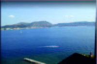
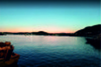
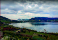
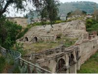
The studied area has a high potential of development regarding green-blue infrastructure due to the dominant presence in the territory of the Gauro Mountain but also for the access to the Mediterranean Sea.
Gauro Mountain is the volcanic formation with the highest pick it’s a part of the Regional Park situated in the Phlegraean Fields. This area is very important for the ecosystem and it’s also a protected area part of the Natura 2000 Network.
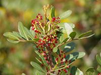
The mountain is an identity element for this zone, with flora and fauna specific for this type of territory and characterized by thick Mediterranean vegetation like chestnut in the north side and plants like cistus[1], mastic trees[2] and myrtle[3] in the steep west side. Also, in the past, in the neighborhood territory of the mountain, was cultivated vines, valuable agriculture areas nowadays.
This important elements of green-blue infrastructure are in a continually changing because of the human intervention and also the urbanization causing in more cases pollution of the environment. We can see this urban development also in the crater of the Mount Gauro, where now is the Carney Park- a recreational facility of the US Navy that can't be visited by other users different of the US Navy stuff. So, because of this limitation, the landscape in this part, from the top of the mountain is not valued as it should be.
Natura 2000 Network prevents this type of intervention in the green protected area, and by improving the green-blue infrastructure in a sustainable manner, the ecosystem will be protected better(marine and mountain biodiversity), reaching a sustainable development of the local economy and also of the urbanization.
-
 Green-Blue Infrastructure
 -
 Gauro Mountain
 -
 Portus Julius
 -
 Pozzuoli Port
 -
 Top of Gauro Mountain
 -
 Mastic tree
 -
 Myrtle
 -
 Cistus


Actors and stakeholders
Strong Actors in the Rione Terra-Potus Julius area: Mayor, Municipal council, Environment department, Development authorities, State, Ministry of the environment, International organizations.
Weak actors: Local residents, Local societies, Tourists, Fishing communities.
Here, International organizations have higher authority and they have the liabilities most.
Local authorities have high power and gets affected more because of the locality.
Local dwellers contain less power but have the highest interest and effect.
Tourists have less power and have less stake or effect.
-
 Rione Terra powermap

Sacred spaces and heritage
The Rione Terra quarter represents the multilayered historic city of Pozzuoli, the heart of the city and its ancient acropolis, and it was founded by the Romans in the 2nd century B.C. The stratifications and the layers are visible, but under the level of the contemporary city. Following restoration and redevelopment of both the Rione and the archaeological itinerary underlying from the Roman era, from 2014 it was opened to the public.
Which places/elements hold cultural value and to whom?
Rione Terra, being a multilayered historic area, features many well-preserved heritage sites. They hold great value to the locals because they represent the entire history and identity of this culture. They also hold value to the tourists, which are mainly attracted to these beautiful wonders of the past, integrated into the present atmosphere of the city.
- Pozzuoli Cathedral or the Basilica of San Procolo Martire is the main Roman Catholic church in Pozzuoli. The church was first housed in a former Roman temple, the Temple of Augustus built by the rich merchant Lucius Calpurnius. Accelerated bradyseism in 1983-1984 led to the monument being totally abandoned in 1992, leading to vandalism and looting. Finally, the Regione Campania launched an architectural competition for the restoration in July 2003. In the entrance façade, a glass portal reconstructs the colonnade pronaos of the temple; from here, passing by the cell, in which it is possible to see the cuts made in the columns for building the church, the visitor meets the apse part of the Baroque era; the lights in the ceiling recreate the constellations visible in the sky when Saint Paul the Apostle landed in Pozzuoli in 61 AD. Restoration works have respected the marks of the time, keeping them visible, in order to identify the passages from the Roman era to the Renaissance-Baroque, returning to the city a cathedral a little bit different from how it was, but of great impact and deep in history.
- The Flavian Amphitheater is the third largest Roman amphitheater in Italy and it is sharing its name with the most famous of the Roman structures. It was likely built by the same architects who previously constructed the Roman Colosseum and it gives a unique and arguably deeper look into the world of Roman spectacle and gladiatorial combat. In 305, the arena was the setting for the persecutions of the patron of Pozzuoli, Saint Proculus, and the patron saint of Naples, Saint Januarius. Visitors can also go beneath the arena to explore the underground complex below the surface and, in doing so, get a sense of how the amphitheater operated in antiquity.
- Macellum of Pozzuoli was the macellum or market building of the Roman colony of Pozzuoli. When first excavated in the 18th century, the discovery of a statue of Serapis led to the building being misidentified as the city's serapeum or Temple of Serapis. The three standing marble columns indicated that these columns had remained upright over centuries while the site sank below sea level, then re-emerged. This puzzling feature was the subject of debate in early geology and eventually led to the identification of bradyseism in the area, showing that the Earth's crust could be subject to gradual movement without destructive earthquakes.
- The necropolis of San Vito, so-called due to the proximity of one small church dedicated to Saint Vito, is today a forgotten complex, in some ways abandoned and open to a few scholars.
- Necropoli di Via Celle stands out among other necropolis for its majesty. After Rome, Pozzuoli is the city in the world that contains the greatest number of funerary monuments from the Roman era. Like most streets on the outskirts of Roman cities, it was lined with burial grounds, so the Necropolis of Via Celle is undoubtedly the most majestic "cemetery" of the Roman era.
- Stadio di Antonino Pio, unearthed in 2008, was built by emperor Antoninus Pius in honor of the Hellenic spirit of his predecessor Hadrian. The building is located near one of the villas of Cicero, where Adriano was buried after his death in Baia in 138 A. D. This Stadium, hosted a sort of Olympic-type sport event that occurred every five years known by the Greek name of Eusebeia. The stadium was located on via Domitiana (today via Luciano) where it can be admired to this day in all its grandeur. The entire area was buried following the eruption of Monte Nuovo of 1538 while some parts were incorporated in a farmhouse in the 19th century. The modern via Domiziana has cut lengthwise this historical artifact compromising its unity.
- Temple of Neptune: Similarly to Baia, Pozzuoli was famous for its thermal baths with the most famous one being the so-called Temple of Neptune where well-preserved remains can be visited today not far from the Anfiteatro Flavio. The walls were part of the frigidarium, also known as the cold environment while the rear portion of this structure was enriched with a central apse adorned by niches and arches. The rooms arranged on the sides had vaulted ceilings or barrel vaults. The thermal complex must have appeared as an impressive building, visible from the sea, built in the 2nd century A.D. and used until the fourth century A.D.
-
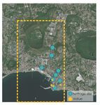 Map of heritage sites
 -
 Cathedral of Pozzuoli
 -
 Anfiteatro Flavio
 -
 Macellum of Pozzuoli
 -
 Necropoli di San Vito
 -
 Necropoli di Via Celle
 -
 Stadio di Antonino Pio
 -
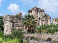 Temple of Neptune


Visual appearance and landscape narrative
Rione Terra is the first settlement of Pozzuoli. It is placed on a hill, which stands 33 m from the sea. Its position has always been positive to control the arrival of the enemies from the sea and from the land. Unfortunately, due to bradyseisms and especially the earthquake in 1984, Rione Terra was the subject of a great work of retraining and restoration. Finally, it was opened in 2014. Today, this area is very interesting to visit because it is a really overlapping of housing layers.
Through the years, many important people had been inspired by this place. A great example, which is able to summarise the essence, is Alberto Angela's quote. The Italian paleontologist tells:There is a neighborhood where chapters of Pozzuoli's long history are overlapped like the pages of a book.
While, between VIII and IX century A.D., there are some lines written in the Acts of St. Peter and Paul, from the apocryphal Gospel, they justified the sinking of the city to a miracle. It was operated by the apostle Paolo to punish the city where was executed the master of the ship, whit which the saint arrived from Orient. Moreover, also the geographer Strabone, explains his thoughts about. He considered the fortress as the landing of the exiles of the island of Samo, who founded Dicearchia, the government of the correct ones.
Thanks to its suggestive character this area has been also the subject of lots of paintings.
In 1764 G.P.Bollori re-made a painting, which was lost. This one showed the port area and that right there was a temple dedicated to Apollo, it was located on the first acropolis of Pozzuoli.
There are also other views from the nineteenth century, made by Franz Ludwig(1830) and the canvas made by Consalvo Carelli.
-
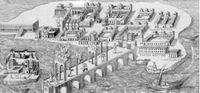 Painting by Bollori of Rione Terra in 1764
 -
 View of Rione Terra by Franz Ludwig in 1830
 -
 Oil on canvas by Consalvo Carelli from the 19th century
 -
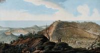 The Crater of Monte Gauro by William Hamilton 1776


A.2 Summary of you landscape system analysis and your development Targets
Landscape System Analysis - DPSI(R) diagram
-
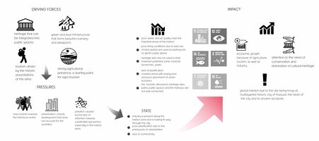 Rione Terra's driving forces are its heritage, the landscape, and tourism that happens because of it. This creates a great base for economic growth. These driving forces obviously create pressures on the area and so the worst felt effects are mass tourism, urban sprawl, and pollution. This impacts some of the Sustainable Development Goals, such as: 11. Sustainable Cities and Communities, 13. Climate Action, 14. Life Below Water, 3. Good health and well-being, Affordable and Clean Energy, Life on Land. There are then two types of impact on the landscape: a negative one, and a positive one. The negative impact is causing the disturbance of the landscape, pollution of air, water and soil, economic exploitation, and the start of one chaotic urbanization and possible damage to the heritage. On the other hand, there are positive effects such as: the conservation and restoration of the cultural heritage, the possible economic growth that happens because of tourism and global interest for Rione Terra.

Landscape hypothesis
-
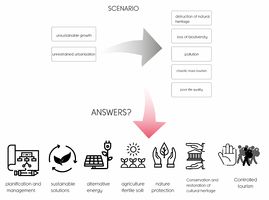 Our hypothesis is that the unsustainable growth and chaotic urbanization are the causes for pollution, destruction of the natural heritage and loss of biodiversity which also leads to a low quality of life. The answer for solving the problems in this scenario is a sustainable development using alternative energy, nature-based sustainable solutions and planfication for the urban development. We thought that other solutions for the problems are to protect nature and the cultural heritage by preserving and restoring it. Also, near the mountain, because of lava minerals from the volcanic eruptions, the soil here is very fertile, and the land has agricultural potential, so we can use this potential in our future development strategy.

A.3 Theory reflection
Plans and policies play a crucial role in understanding the various concepts related to conserving and formulating landscapes. They are not just guiding the users, but also the competent authorities to safeguard the same. Discussing policies at International, European and local level are as followed:
At the International level, the UN HABITAT Planner for Climate Change plays a crucial role in developing the guidelines for the policy that highlights the impact of climate change, at a global and unprecedented scale. It embarks the causes of pollution and how to integrate global measures for the same as an integral part of planning. It is to be applied at different scales, climate-friendly built environment and introducing concepts like participatory planning, green infrastructure, etc.
The second policy or the European policy to be considered is the European Landscape Convention (Florence, 2000) which very basically defines the landscape and the policy as two dependent entities reforming the whole structure of landscape as one. It establishes the concept of human beings at the center of the system thus identifying landscapes and how to protect them.
The third local level policy is the Integrated Coastal Zone Management plan in Italy, in which the plan describes the gap between the scientific community and the people responsible for the formulation of plans, thus depicting the loose control at a national level, thus leaving the regional and lo authorities unguided. It is an interlinked system incorporating all from the stakeholders to the users, thus all these policies should be interlinked.
A.4 References
[2] http://www.napolike.com/tourism/place/district-earth-pozzuoli-napoli/
[3] http://www.pressreader.com
[4] https://www.likealocalguide.com/naples/rione-terra(fig.4)
[5] https://www.flickr.com/groups/napolinobilissima/discuss/72157633306343537/#comment72157635169401115
[6] https://it.wikipedia.org/wiki/Monte_Gauro
[7] http://www.naplesldm.com/gauro.php
[8] Geotechnics and Heritage: Case Histories
[9] http://www.rioneterrapozzuoli.com
[10] http://www.pafleg.it/it/1/home
[11] https://izi.travel/en/italy/city-guides-in-campania-pozzuoli
Phase B: Landscape Evaluation and Assessment
B.1 Assessment Strategy
Based on the hypothesis derived from our previous landscape system analysis, we defined some goals that try to gradually improve the status of this area, by using its strengths to deal with the weaknesses. Our goals are trying to improve the status of tourism, transport infrastructure and of the coastal landscape. We also try to avoid the chaotic development caused by the lack of plannification and uncontrolled tourism. Therefore, our goals are:
- To create a coherent system that connects the green and blue infrastructure, the heritage and the existing viewpoints that reveal the beautiful landscape.
- To reconnect the city with the harbor/coastal landscape by increasing its attractiveness.
- Smart use of the land. What can we build there?
- Improve transport infrastructure for better accessibility.
- Controlled tourism: What does it mean? How can we do that?
B.2 Mapping
-
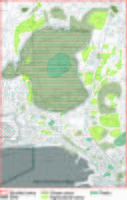 Green-blue infrastructure: Besides the public parks of the area and Monte Gauro, we found that our area has a great deal of agriculture land, a strong agricultural presence, and a starting point for agro-tourism. There are also some heritage sites that can be integrated into the green system, because they are mostly covered in vegetation. We envision a route that can link all the green spaces into a coherent system.
 -
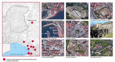 Mapping of potential public spaces in Rionne Terra: The Rione Terra quarter represents the multilayered historic city of Pozzuoli, the heart of the city and its ancient acropolis. There are many heritage sites that have been preserved, in either good or poor condition. At the same time, there are also some plazas where people can find monuments and statues, plazas that hold a certain meaning to the people and that are located in close proximity to the heritage sites. Two of these squares are also located along the harbor area, and they reveal beautiful viewpoint and scenery. We found that many of these places are either abandoned, not well kept, not used to their maximum potential or even turned into parking spaces. Some are not accessible to the public, or lack attractiveness. Some heritage sites, such as the Temple of Neptune, present a great deal of vegetation, so they can be integrated into parks or other kind of green public spaces, even memorial public spaces. They can become great losir places for the people of the city and great touristic attractions, if they are integrated into a green system.
 -
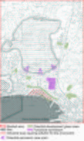 Areas that can go through functional conversion: In this case, our mapping reveals problems related to the land-use in the area. The lack of planification created areas with empty land and some poor placement of urban functions, such as the industry that disrupts the flow of the living areas. We found some areas that can be turned into green spaces, some with great viewpoints to the landscape, on the top of Monte Gauro. Meanwhile, we also marked the industrial area of the harbor which can cause a great deal of pollution to the water and coastal landscape. The water bank is not well taken care of and it would be a great place for a promenade.


B.3 Problem definition and priority setting
*Give a summary of the major findings of your mapping process, what are the problems/potentials identified?
The Rione Terra study area presents a few distinct elements that can greatly enhance its development. First of all, we have identified an existing agrarian landscape and heritage, that can greatly boost the economy. What is more, besides the coastal landscape and Monte Gauro, the area consists of many green spaces, that are unfortunately not very well connected which leads to underutilization of the resources available.
Secondly, the Rione Terra study area is a potentially high area for the economy because of its cultural heritage, having many heritage sites and sacred places that have been preserved. To link this to the first mapping, we found out that many of these sites are nearby urban plazas that are not very well kept. Some are not accessible to the public, or lack attractiveness. Some heritage sites, such as the Temple of Neptune, present a great deal of vegetation, so they can be integrated into parks or other kinds of green public spaces, even memorial public spaces. They can become great losir places for the people of the city and great touristic attractions if they are integrated into a green system. These findings can, in fact, enhance the economy of this area through historical tourism and agriculture or even agro-tourism. Of course, tourism needs to be controlled because it can damage the heritage sites and can greatly pollute the area.
The third part of the mapping leads us to understand the need for functional conversion in some areas. Some areas of great importance get developed much faster as compared to the others. The positive outcome could be re-establishing these structures into some green spaces or connection nodes to the bigger structure thus enhancing the functional and aesthetical value of the area and improving the overall standards for the city. The industrial area of the harbor which can cause a great deal of pollution to the water, can affect the green and blue landscape, because it is downgrading its attractivity.
To summarize:
One potential risk that we have found it's given by the potential for sea level growth that can jeopardize both port activities and the population. Another risk comes from the exploitation of green land, so a possible negative effect may be the loss of biodiversity caused by pollution. Becoming a very popular area for historical tourism, the increasing the number of tourists may be a negative effect on the environment as well as the resources of the area.
-
 Potentials/risks diagram

*Set priorities for the most relevant issues:
The priorities for our most relevant issues presented in the scheme above can be:
- valorization of the agricultural areas in a sustainable way by linking them into a green-blue system and developing agro-turism
- reducing environment pollution by converting the industrial areas form the port that pollute the air and also the water into light industry less polluting
- economic sustainable development by value the port activity and also turism
B.4 Theory reflection
To evaluate the complex area of the Rione Terra the methods considered were different: after studying the historical aspect and observing the area through google maps, the group chose some important methods that had been able to realize some aspects.
The Landscape & Visual Impact Assessment (LVIA) method: this method helps us to understand the effects of new landscape ideas. By creating a continuous line and reopening many public areas of the terrestrial district (now still closed) the negative effects of the landscape can be reduced or avoided.
Another method is the Blue Health Environmental assessment tool (BEAT), it helped us understand the impact that exposure to the sea has on the people who live there and on tourists.
These methods have a positive correspondence, because they are responsible for increasing tourism, reducing stress for users thanks to the proximity of the sea.
Furthermore, another method used was Ecosystem Services (ES). The last one gives us the possibility to study the naturalistic value of the area. This type of evaluation defines different aspects of the site, through the definition of heterogeneous factors of the Rione Terra system. Including both the risks to the health of ecosystems and the potential to provide a service.
B.5 References
- give a full list of the references you have used for this section
Phase C – Strategy and Master Plan
C.1 Goal Setting
The coastal area of the results of the Rione Terra and Portus julio evaluation has led to five objectives that aim at sustainable local regeneration. According to the studies carried out, five strategic planning objectives have been designed.
-To increase public transport lines and limited traffic areas, the aim is to reduce pollution. This objective is linked to objective 3: to ensure health and well-being for all and for all ages, and to objective 11: Making cities inclusive, safe, resilient and sustainable.
-Investing in sustainable industries and innovative development technologies. in fact, in the port area, there is the greatest number of human activities; moreover, there is a reduced amount of vegetation, which could prevent the collapse of the ridge, and there is most of the illegal constructions that undermine its integrity instead. This objective is linked to objective 9: building resistant infrastructure, promoting sustainable industrialization and innovation.
-Focus on sustainable economy, such as tourism and the fish market. This objective is linked to objective 8: Promote lasting, inclusive and sustainable economic growth, full and productive employment and decent work for all.
-Other is the protection of the cultural and natural heritage and the reduction of pollution and the increase in the ecological network. These objectives are linked to objective 14: conserving and sustainably using the oceans, seas and marine resources and objective 15: sustainable management of forests, combating desertification, halting and reversing land degradation, but also with objective 12: Guaranteeing sustainable consumption and production models
 |
Goal setting
|
Goal setting
C.2 Spatial Strategy and Transect
The intervention focuses on those that are fundamental elements received from the analysis. Attention to cultural heritage, attention to connections with the attraction of the landscape and attention to human well-being. identifying those that are critical points, we went to work creating links that took into account (especially in the industrial area) the fragmentation of the area, going to rejoin it. We have created links (the green ones) that go to mend sea and land . Through purely pedestrian paths made of broad points of view. With gray, we have highlighted the inclusion of a cycle path that runs alongside the coast. To give the coast back to the citizens we have worked considering a band as uniquely destined for the passage and the free vision of the landscape. However, as far as buildings are concerned, the intent is not to eliminate them completely, but to create a multifunctional pole with an L shape. And two other elements intended for catering and overnight stays respectively. The intent of this project is to give the sea back to those who live in this area rich in history and life.
-
 TRANSECT
 -

-
 OUR VISION
 -


C.3 From Theory of Change to Implementation
According to the goals of the project we have developed our own in order to improve the quality of its inhabitants and visitors. Our area was initially a large industry, so it was necessary to restore and reclaim the industry to regrow cleanly. As support for these new activities, infrastructures must be upgraded to ensure the flow from neighboring municipalities, reduce traffic and pollution and develop the interest of private investors in commercial activities and tourism attractors. A new clean network would allow the whole area to be accessible to citizens and foreigners. At the moment this area has a great potential. For all these reasons, we hope to fulfill the prefixed objectives of the sustainable development.
-
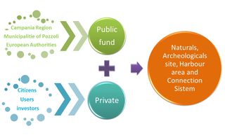 Governance model
 -
 Process timeline


C.4 References
- give a full list of the references you have used for this section
D. Process Reflection
This experience has taught us many things, working in a group of people of different nationalities, having self-control to present in a language different from ours, but above all we have got to know our territory better and make it known also to non-Italian students. thanks for everything.
