Case Study A.1: Pozzuoli-Solfatara-Astroni: Difference between revisions
| (208 intermediate revisions by 9 users not shown) | |||
| Line 17: | Line 17: | ||
| '''Topics''' || style="background:Lavender"|''Coastal Line Study, Understanding Coastal Landscapes, Evaluation and Assessment for Coastal Landscapes Integrated Planning and Design for Coastal Landscapes'' | | '''Topics''' || style="background:Lavender"|''Coastal Line Study, Understanding Coastal Landscapes, Evaluation and Assessment for Coastal Landscapes Integrated Planning and Design for Coastal Landscapes'' | ||
|- | |- | ||
| '''Author(s)''' || style="background:Lavender"|''Calin Sorina, Grigorov Ana-Maria, Trifan Loredana, Gontila Larisa, Hamid Gohari, Sanja Budinski, Claudio Miccoli, Ivana Punzo, Lia | | '''Author(s)''' || style="background:Lavender"|''Calin Sorina, Grigorov Ana-Maria, Trifan Loredana, Gontila Larisa, Hamid Gohari, Sanja Budinski, Claudio Miccoli, Ivana Punzo, Lia Chowdhury'' | ||
|- | |- | ||
| colspan="3" align="center" style="background:silver"| [[File: | | colspan="3" align="center" style="background:silver"| [[File:Base map 1.jpg|border|400px]] | ||
|- | |- | ||
| ||style="background:Lavender"| | | ||style="background:Lavender"| | ||
| Line 27: | Line 27: | ||
= Rationale = | = Rationale = | ||
'''Keywords: mixt area, biodiversity, economic potential''' | |||
Pozzuoli-Solfatara-Astroni area is very important as a mixt area, consisting in an urbanized area and a biodiversity and various landscape forms that highlight the potential of the area. | |||
The further study case is structured in three steps: understanding coastal lanscape, evaluation and assessment for coastal landscape (a diagnostic of the area, what are the ”symptoms” and most important, the causes of them) and, finally, an integrated planning and design for coastal landscapes (ideas and projects to solve or improve the present situation discovered in the first two steps to protect and highlight the main characteristics of the zone). | |||
Furthermore, the case study will have two big perspectives: the need of urbanization, touristic development and to cover the need for the locals and tourists (outlining the need for a stable and efficient economic system) and the need to protect the biodiversity and the landscape. | |||
This two need should merge, support each other and define a complex systems in which every element and relationship between them are to be considered in the future development of the area. | |||
= Location and scope = | = Location and scope = | ||
''You can edit this map with the [[Special:MapEditor|map editor]]'' | ''You can edit this map with the [[Special:MapEditor|map editor]]'' | ||
{{#display_map: | {{#display_map: 40.82682755158355,14.1426144354391 | ||
}} | }} | ||
= A Landscape System Analysis = | = Phase A: Landscape System Analysis = | ||
== A.1 Landscape layers and their system context == | == A.1 Landscape layers and their system context == | ||
=== Geomorphology, landscape units and coastal typology === | === Geomorphology, landscape units and coastal typology === | ||
'''Typology: ''Volcanic geomorphology- Volcanic Coast''''' | |||
Volcanism creates and degrades lanforms (directly), and provides and age for both the landsurface over which the erupted material lies and the succession in which is intercalated (indirectly). Volcanic geomorphogy, in contrast to other types of landforms, result from both constructive and destructive forces near-simultaneously. | |||
The Solfatara area and its fumaroles are the main surface expression of the vigorous hydrothermal activity within the active Campi Flegrei caldera system. A range of volcanic and structural processes dictate the actual state of the hydrothermal system below the crater. The presence of a large variety of volcanic products at shallow depth (including ash beds, pyroclastic density current deposits, breccias, and lavas), and the existence of a maar-related fault system appears to exert major controls on the degassing and alteration behavior. Adding further to the complexity of this environment, variations in permeability and porosity, due to subsoil lithology and alteration effects, may further influence fluid flow towards the surface. | |||
The hydrothermal activity across the crater floor of Solfatara produced very different morphologies and types of soils. In this area we can find the following sobsoil type: | |||
1. Zones dominated by thin, laminated depoits of finegrained material are found around the two bubbling Fagaia mud pools. | |||
2. A firm fine-grained level, mostrly composed of amorphous silica, has formed in the western altered part of the crater where this depost covers that of the Fangaia mud pools. | |||
3. A subsoil made up of subordinate fine-grained and mainly sandy/pebbly levels characterizes the center of the crater. | |||
4. Large mounds made of sulfur-cemented sandy/pebbly levels and minor intercalated fine-grained levels, covered by a hard, surficial patina. | |||
Coastal elevation changes can occur in area affected by volcanic-tectonic deformation. This phenomenon is found in the Pozzouli zone- the archaeological ruins of Pozzuoli on the Phlegrean Fields in the Bay of Naples- the bioeroded columns of the port’s Roman market were made famous. | |||
Relative sea-level movements at Pozzuoli are far more intense than the average 50 cm sea level rise recorded in the north west Mediterranean Sea since Roman times. There are 3 key moments post Roman period: first, submersion in a period of marine transgression (AD 400-550), without volcanic eruption, second, submersion affected the land without eruptive activity followed this inundation (AD 700-900), and third, submersion occurred in the Middle Ages when it was a major eruption in 1538. | |||
More recently, the sea level grew with 3.5 m, although no eruption occurred during those periods. The dominant sea-level change signal is linked to phases of volcanic activity and quiescence. | |||
The most important sites in the case study of Pozzouli-Solfatara-Astroni area that should be detailed are: Campi Flegrei and the Astroni Nature Reserve. | |||
''Campi Flegrei'' is a 75 km2 volcanic area located to the west of Naples. It was declared as a regional park in 1997. This area both geology and history. Campi Flegrei comprises a substantial number of sites that are remarkable for scientific quality, rarity, aesthetic appeal and educational value, valuable for their geological heritage. The interest for both scientists and general public (locals and tourists) is archaeological, ecological, historical or cultural. The Campi Flegrei volcanic sites also represent one of the highest volcanic risk areas in the world. Important geosites that are included in Campi Flegrei is Cuma, Averno, Monte Nuovo, Solfatara, Piperno and Monte di Procida. | |||
''Astroni Nature Reserve'' has been well known since the of Ancient Rome, when it was used for therapeutic baths. After the unification of Italy, Astroni suffered progressive degradation. Touristic attraction uncontrolled and unregulated use of the land destroyed the natural environment. Nowadays, Astroni Reserve belongs to the Campania Region. It comprises one of the volcanic craters of Campi Flegrei and is situated 16 km from the center of Naples. The Astroni crater is home to a great variety of habitats. | |||
The coastal typology is in a slow change due to diverse factors, such as: ''earthquakes, landslides, volcanic eruption, uncontrolled hazard zones'' (see Hazard maps below), and ''uncontrolled human intervention'' in the area and in the surrounding area. | |||
<gallery caption=" " widths="200px" heights="150px" perrow="5"> | <gallery caption=" " widths="200px" heights="150px" perrow="5"> | ||
File: | File:Topo map.jpg|''Topographic relief map- the most important sites'' | ||
File: | File:Hazard map 1.jpg|''Hazard Map: Pyroclastic Density Current Invasion Hazard'' | ||
File:Hazard map 2.jpg|''Hazard Map: Vent opening probability'' | |||
File:Solfatara.png|''Solfatara crater, author Patrick Massot, date 18 October 2014, 17:29:43'' | |||
File:Mud pool in Solfatara crater.jpg| ''Mud pool in Solfatara crater, author Patrick Massot, date 18 October 2014, 17:29:43'' | |||
File:Oasiastroni.jpg| ''Astroni Nature Reserve, author Holly Willmott, date 4 July 2014'' | |||
</gallery> | </gallery> | ||
=== Land use === | === Land use === | ||
Pozzouli was founded about 531 BC by Greek emigrants who called it Dicaearchia, the city of justice. After captured by Rome, it had the status of a Roman colony from 194 BC. The Romans called the city Puteoli meaning small wells, perhaps due to the availability of numerous thermal-mineral water springs. After Roman conquering the East, the need to have a stopover open to traffic with it made Puteoli the Mediterranean port of Rome which made it a leading commercial centre and a cosmopolitan city. However, it declined with the fall of the Roman Empire and the gradual sinking of the Puteolan coast, caused by bradyseism, forced the inhabitants to leave the lower part and the harbor areas of the city and to settle on the hill at the end of the 5th century or at the beginning of the 6th century. In the early 1970s the old Roman market, the Temple of Serapis of the 1st century AD was partially submerged due to bradyseismic activity. After the phenomena occurred in the seafront, urban expansion moved toward internal and more rural areas which was completely sudden and unregulated. | |||
Pozzuoli is on the Rome-Naples railway line and has a small commercial port. Public transportation is good near coastline while time consuming with indirect public transportation services towards north. The economy of this area is based largely on tourism, commerce, industry and agriculture. The fertile countryside supports a major food-processing industry in the town, which also engages in fishing and the manufacture of machinery. A number of residents work in the iron- and steelworks at nearby Bagnoli. Many factories have shut down within the last few decades. | |||
Thus, Pozzuoli the connecting point of rural, urban and industrial areas has gone through massive urbanization specially in the coastal area through last fifty years. In the given area urban fabric is denser in the hillside coastal area with mostly three to five storied buildings. The pedestrian friendly green belt alongside the coastline provides a welcoming seafront for the citizens. The area has still vast fragmented green areas of broad leaved forest, agriculture land, herbaceous plant vegetation, pastures as well as small urban green patches. There is also industrial and commercial area close to the coast while some future planning can be thought about the abandoned industrial areas. A huge aeronautical academy is currently working in top of the hill providing professional trainings to young people. There are some other land uses like sports, recreation & also mineral extraction from semi active volcano solfatara. Overall the current urban fabric and the industrial-commercial areas are dominating the site and will possibly be dominating in future as well with a threat of converting landuses due to massive tourism and population growth. However, considering ecological connection through the green areas and improving public transportation services specially between Agnano and Solfatara could be a great opportunity to achieve sustainable development goals. | |||
<gallery caption=" " widths="200px" heights="150px" perrow="5"> | <gallery caption=" " widths="200px" heights="150px" perrow="5"> | ||
File: | File:5 Existing Road Connection upload .jpg|''Map Showing Road Connection of the area'' | ||
File: | File:1 urban fabric upload.jpg|''Map showing Urban Fabric, sudden and unregulated settlement away from the coast due to 1970's bradyseism'' | ||
File: | File:2 green areas upload.jpg|''Map showing fragmented Green Areas including forest, crops and vegetation, pastures and urban green spaces'' | ||
File:3 industrial and commercial upload.jpg|''Map showing Industial & Commercial Areas'' | |||
File:4 overalll landuse upload.jpg|''Landuse map combining layers of urban fabric,forest and green lands and industrial commercial areas'' | |||
File:Pozzouli Coastal urban image.jpg|''Dense Urban image in Coastal area of Pozzuoli'' | |||
File:Pozzouli Vineyard near Astroni.jpg|''Vineyard image near Astroni'' | |||
File:An Abandoned Industrial Area image near Pozzouli Coast .jpg|''An Abandoned Industrial Area image at Bagnoli near Pozzuoli Coast'' | |||
</gallery> | |||
<gallery caption=" " widths="500px" heights="200px" perrow="5"> | |||
File:Coast solfatara astroni coland section 1.jpg|''Section through Coast-Solfatara-Astroni '' | |||
</gallery> | </gallery> | ||
| Line 70: | Line 115: | ||
=== Actors and stakeholders === | === Actors and stakeholders === | ||
* | * The first type of stakeholders is organizations and governmental associations in the area. The area is under the supervision of the municipality of Pozzuoli which is one of the main stakeholders with the high level of interest and the influences. The municipality of Pozzuoli is responsible for urbanistic plans and programs. The Superintendence for cultural heritage is the highest-ranked interest organization in the area that is caring for landscape and developing leisure and recreation of the area. Campania Region, as one of the stakeholders with a considerable level of interest, is planning for seashore protection and masterplan. Local people, tourists, investors, and businessman are considering as the second type of stakeholders. This type has a crucial role in the eco-social and environmental situation of the area. They can lead by the first group of the stakeholders to improve and promote the development factors of the area of the Pozzuoli. | ||
<gallery caption=" " widths="500px" heights="200px" perrow="5"> | <gallery caption=" " widths="500px" heights="200px" perrow="5"> | ||
File: | File:Power_map_groüp 1_draft1.jpg|''Power map'' | ||
</gallery> | </gallery> | ||
=== Sacred spaces and heritage === | === Sacred spaces and heritage === | ||
* | * The Flavian Amphitheater is the third largest Roman amphitheater in Italy. It was begun under the reign of the emperor Vespasian and probably finished under the reign of his son Titus. The arena can hold up to 50,000 spectators. The interior is mostly intact and one can still see parts of gears which were used to lift cages up to the arena floor. The site of the structure was chosen at the nearby crossing of roads from Naples, Capua and Cumae. It was abandoned when it was partially buried by eruptions from the Solfatara volcano. During the Middle Ages, the marble used on the exterior was stripped, but the interior was left alone and is perfectly preserved. | ||
* | |||
* The Temple of Serapis sits not far from the sea in the ancient town of Pozzuoli.It is not a temple at all, as its name would suggest, it is an important symbol of the region’s Roman roots, and more importantly, of the geologic forces at play in the Campi Flegrei. Serapis is the god of the underworld, as well as the god of the sun, healing, and fertility. Ptolemy I of Egypt created Serapis as an Egyptian-Greek god to unite the two cultures. Near the macellum there is that it lies about 30 feet below sea level. Its ancient granite columns seem to be suspended atop a mirky pool of water, leaving you with the impression that they are either rising up from or descending into the sea. Originally attributed to changes in sea level, geologists later learned that the ground was moving slowly up and down with the ebb and flow of magma chambers deep within the earth. From the Greek bradus, slow and sism movement, bradyseism is prevalent throughout the Campi Flegrei and the macellum is perhaps the most important example of it in the world. In fact, scientists have been documenting the ruins’ movements since the 18th century, when they found evidence of molluscs on several columns indicating that the columns were at one time submerged to a depth of at least 7 meters. | |||
<gallery caption=" " widths="200px" heights="150px" perrow="5"> | <gallery caption=" " widths="200px" heights="150px" perrow="5"> | ||
File: | File:Anfiteatro Flavio Pozzuoli.jpg|''Flavian Anphitheater - I century a.C.'' | ||
File: | File:Tempio Serapide.jpg|''The Temple of Serapis'' | ||
File: | File:Macellum Pozzuoli.jpg|''Macellum (Serapis temple) I – II century a.C.'' | ||
</gallery> | </gallery> | ||
=== Visual appearance and landscape narrative === | === Visual appearance and landscape narrative === | ||
Solfatara make unique the city of Pozzuoli because of the underground process: its sulphurous soil, underground water, jets of steam who pierce the crust of earth, the tremble of ground and the hot mud who comes to the surface bubbling over. This area is permeated by the strong smell of sulphur, it looks like the gates of Hades. | |||
Rione Terra is the only part of Pozzuoli that has all the stratifications from greek period till now. | |||
Legends and miths are settled in this lands since Greeks and Romans. In the XVIII century when the Grand Tour spread all over Europe many artists such as Peter Fabris, Michele Mercati, Johannes Stradanus, Gaspar Van Wittel and Jakob Philip Hackert painted the magical athmosphere of Pozzuoli, Naples and Bay. This Vulcanic Land has inspired also well known poets from Omer, Horace, Vergilius and Boccaccio till Goethe, Madame De Stael. | |||
*The first engraving above is an extraordinary proof of the expeditions of Sir William Hamilton by Peter Fabris. Hamilton is ambassador of the British Empire in Naples, a keen observer of local life and customs, as far as the scientific aspect is concerned. He has the task of informing British scholars about the activities of Vesuvius and Phlegraean Fields and the archaeological of Pompeii and Herculaneum. He visits the Solfatara of Pozzuoli even during eruptions to observe better the evolution. In this pictorial testimonies, Hamilton observes the gas fumes from a mouth of the Solfatara of Pozzuoli. | |||
*The second engraving is from an original by Mercati. The beauty of the composition relies on the circular shape of the crater which, in reality, has a more irregular and elongated shape. | |||
*The third picture instead, is Stradanus’s engraving who puts less emphasis on the composition and on the crater itself, but in his description is rich in dramatic in detail. Stradanus is particularly successful at depicting the light,the dirt at the centre of the crater and its quality, which is sandy at the top, and moving, almost fluid just below. He also situates the solfatara in its urban context | |||
<gallery caption=" " widths="200px" heights="150px" perrow="5"> | <gallery caption=" " widths="200px" heights="150px" perrow="5"> | ||
File: | File:Hamilton admires Solfatara Peter Fabris.jpg|''Hamilton admires Solfatara, Peter Fabris'' | ||
File: | File:Solfatara of Pozzuoli Michele Mercati.jpg|''Solfatara of Pozzuoli from Michele Mercati's (1541-1593)'' | ||
File: | File:Solfatara Johannes Stradanus.jpg|''Detail from Solfatara, engraving by Johannes Stradanus (1523-1605)'' | ||
</gallery> | </gallery> | ||
== A.2 Summary of you landscape system analysis and your development Targets == | == A.2 Summary of you landscape system analysis and your development Targets == | ||
The Sustainable Development Goals are the blueprint to achieve a better and more sustainable future for all. Some of the goals targeted for 2030 for sustainable development are at risk in the area of Pozzouli-Solfatara-Astroni. | |||
Promote inclusive and sustainable economic growth, employment and decent work for all, Goal 8: Sustainable economic growth will require societies to create the conditions that allow people to have quality jobs that stimulate the economy while not harming the environment. | |||
Build resilient infrastructure, promote sustainable industrialization and foster innovation, Goal 9: We can upgrade infrastructure and retrofit industries to make them sustainable, with increased resource-use efficiency and greater adoption of clean and environmentally sound technologies. Also adaptive reuse of abandoned industries can ensure certain benefit. | |||
Make cities inclusive, safe, resilient and sustainable, Goal 11: It is possible to strengthen our efforts to protect and safeguard cultural and natural heritage and providing universal access to safe, inclusive and accessible, green and public spaces. | |||
Take urgent action to combat climate change and its impacts, Goal 13: Strengthening resilience and adaptive capacity to climate-related hazards and natural disasters is also required. | |||
Conserve and sustainably use the oceans, seas and marine resources, Goal 14: We need to prevent and significantly reduce marine pollution from land-based activities, including marine debris and nutrient pollution. Also sustainably managing and protect marine and coastal ecosystems to avoid significant adverse impacts, including by strengthening their resilience, and take action for their restoration in order to achieve healthy and productive oceans. | |||
Sustainably manage forests, combat desertification, halt and reverse land degradation, halt biodiversity loss, Goal 15: Ensuring the conservation, restoration and sustainable use of freshwater ecosystems and their services, in particular forests, wetlands and hilly areas in line with obligations under international agreements. Promoting the implementation of sustainable management of all types of forests, halt deforestation, restore degraded forests and substantially increase afforestation and reforestation is also necessary. | |||
<gallery caption=" " widths="500px" heights="200px" perrow="5"> | <gallery caption=" " widths="500px" heights="200px" perrow="5"> | ||
File: | File:Dpsir sanja budinski.jpg|''DPSIR Framework is used for system analysis of the area. Population growth is recognized as a major driving force, which together with economic development puts pressures on the human and natural environment. As a consequence, there is landscape fragmentation, loss of natural and cultural heritage as well as deteriorated human wellbeing. A holistic approach to integrated development is a necessary response, which includes various steps for recognizing and conserving the values of the area.'' | ||
</gallery> | </gallery> | ||
[[File:Hypothesis123.png|500px]] | |||
At the current state the urban sprawl, fragmentation of landscapes and ecosystems and as well as the reduced quality of environment are leading the area to three main consequences: Loss of environmental and cultural heritage, biodiversity loss and also reduced quality of life for locals and a decreasing number of tourists. As a result of the rapidly urbanizing areas, agriculture intensifies on remaining undeveloped land and is likely to expand to new areas, putting pressure on land resources. The loss of biodiversity can be related to the antrophic activities. Humans have destroyed and continue to destroy the habitats of species on a daily basis. | |||
== A.3 Theory reflection == | == A.3 Theory reflection == | ||
* '' | *''UN HABITAT. New Urban Agenda: As the area characterized by rapid urbanization as the consequence of population growth, Puzzuoli coast is facing challenges such as Social (Migration), Climate change, Economic development, Demographic change, and Environment recourse management. The New Urban Agenda as guidance for further integrated urban development can facilitate mitigation of the problems such as urban sprawl, losing the identity of the space, unsustainable resource use and lack of participation, mainly through the dialog between multi-stakeholders (public and private sector, working with civil society).'' | ||
* '' | |||
*''European Commission, The Multifunctionality of Green Infrastructure (GI)'', the functions of GI are described in terms of four broad roles as: protecting ecosystems state and biodiversity, improving ecosystem functioning and promoting ecosystem services, promoting societal wellbeing and health and supporting the development of a green economy, and sustainable land and water management. Some of the objectives of EU GI strategy for EU are to enhance, conserve and restore biodiversity by inter alia increasing spatial and functional connectivity between natural and semi-natural areas and improving landscape permeability and mitigating fragmentation, to enhance the societal and cultural link with nature and biodiversity, to acknowledge and increase the economic value of ecosystem services and to create incentives for local stakeholders and communities to deliver them, to minimise urban sprawl and its negative effects on biodiversity, ecosystem services in Europe. GI can be a highly effective policy tool since it can perform several functions at several scales, while taking into account the multiple connections and interactions which are so essential in nature. Benefits of GI include less grey infrastructure, more green jobs, more productive workforce, agriculture as well as increase in property values improving the quality of life. | |||
* '' | |||
*''European Commission. Marine Strategy Framework Directive:'' The aim of the European Union’s ambitious Marine Strategy Framework Directive is to protect more effectively the marine environment across Europe. The european commission also produces a set of criteria and standards to help Member States to adopt this strategy.The aim is to achieve Good Environment Status (GES) by 2020,in order to protect marine resources. The Marine Strategy include the assessment of the current environmental status of marine waters and the impact of human activities.The climate changes can reduce the ability of an ecosystem to persist to other man-induced pressures. Impacts include rising sea levels, increased sea temperatures, precipitation changes, and ocean acidification. | |||
== A.4 References == | == A.4 References == | ||
* '' | * https://en.wikipedia.org/wiki/Economy_of_Naples, date 04.04.2019 | ||
*https://www.britannica.com/place/Pozzuoli, date 04.04.2019 | |||
*http://www.naplesldm.com/geology.php, date 04.04.2019 | |||
*https://www.google.com/maps, date 04.04.2019 | |||
*https://land.copernicus.eu/local/urban-atlas/urban-atlas-2012, date 04.04.2019 | |||
*https://land.copernicus.eu/pan-european/corine-land-cover, date 04.04.2019 | |||
*https://www.un.org/sustainabledevelopment/sustainable-development-goals/, date 04.04.2019 | |||
*https://www.academia.edu/12322699/Community_Supported_Agriculture_in_the_Urban_Fringe_Empirical_Evidence_for_Project_Feasibility_in_the_Metropolitan_Area_of_Naples_Italy_ | |||
* https://en.wikipedia.org/wiki/Pozzuoli, date 04.04.2019; | |||
* https://en.wikipedia.org/wiki/Solfatara_(volcano), date 04.04.2019; | |||
* http://eunis.eea.europa.eu/sites/IT8030007, date 04.04.2019; | |||
* https://www.wwf.it/oasi/campania/cratere_degli_astroni/, date 04.04.2019; | |||
* http://ec.europa.eu/environment/nature/ecosystems/index_en.htm, date 04.04.2019; | |||
* ''Paolo Camilletti, Gianluca Lanzi, Natural and man-made landscape in the Phlegraean Fields: Linking identity and potentials for sustainable development. TRIA 20 (1/2018) 119-140/ e-ISSN 2281-4574. Accessed: 03.04.2019'' | |||
* https://www.napoliunplugged.com/cratere-degli-astroni-nature-reserve.html, date 04.04.2019; | |||
* http://ec.europa.eu/environment/nature/legislation/habitatsdirective/docs/Int_Manual_EU28.pdf, date 04.04.2019; | |||
* https://www.eea.europa.eu/themes/landuse/land-cover-country-fact-sheets/it-italy-landcover-2012.pdf/view, date 04.04.2019; | |||
* https://www.researchgate.net/publication/268096157_Coastal_Geomorphology_and_Sea-Level_Change, date 04.04.2019; | |||
* https://urban.yale.edu/research/theme-4, date 04.04.2019; | |||
* https://link.springer.com/article/10.1007/s12371-011-0033-1, date 04.04.2019; | |||
* https://www.frontiersin.org/articles/10.3389/feart.2017.00072/full, date 04.04.2019; | |||
* https://link.springer.com/article/10.1007/s12371-011-0033-1 , date 04.04.2019; | |||
* https://www.researchgate.net/publication/320989930_Hydrothermal_activity_and_subsoil_complexity_implication_for_degassing_processes_at_Solfatara_crater_Campi_Flegrei_caldera, date 04.04.2019; | |||
* https://www.vulcanosolfatara.it/en/, date 04.04.2019; | |||
* https://www.wwf.it/oasi/campania/cratere_degli_astroni/cratere_degli_astroni__english_version_.cfm, date 04.04.2019; | |||
= Phase B: Landscape Evaluation and Assessment = | = Phase B: Landscape Evaluation and Assessment = | ||
All the resources that we have in this area must be well evaluated and proposed conservation strategies. The strategy helps in future planning of the territory’s open spaces, urban areas, riverine corridors, beach zones and nature reserves. The main goals for the assessment that we need to consider can be short-term or long-term, positive or negative, and may include: traffic,infrastructure capacity, heritage or streetscape character, land stability, biodiversity, people communities. | |||
So, the main issues for our assessment are: | |||
- improving the transport system, for increasing transport efficiency; | |||
- evaluation of ecological and cultural hotspots, because there is an emerging recognition that the diversity of life comprises both biological and cultural diversity; | |||
- protecting of green and blue areas, because they represent a combination of important ecosystems that provide habitat for many species, regular water-cycles and clean air. | |||
== B.2 Mapping == | == B.2 Mapping == | ||
<gallery caption=" " widths="500px" heights="200px" perrow="1"> | <gallery caption=" " widths="500px" heights="200px" perrow="1"> | ||
File: | File:Infrastucture mapping upload.jpg|'''''Mapping 1, Evaluation of Transportation Infrastructure:''' Public transportation in the site is good towards the coastal area with metro and underground subway and metro stations are placed in a good distance interval to become accessible for the public and tourists. However universal accessibility towards beach should be a consideration. Towards north the public transportation is available but more time consuming taking long routes and change of vehicles, for example if a tourist want to go from Solfatara to Astroni, he needs to first take a metro and then he has to take another bus and finally he has to walk around 40 minutes more to reach Astroni which will take altogether around 2 hrs. Also there is no bike route available now could be cause of the hilly areas. If the tourist takes walking route it will take a bit more than an hour to reach Astroni from Solfatara, though it has some private or restricted properties on the way at present.So walking route through green corridors of agriculture and pasture lands and improving pedestrian connections as well as the public transportation especially in the north Solfatara-Astroni side could enhance the accessibility to various hotspots of the site to promote tourism.'' | ||
File: | |||
File: | File:CoLand Assignment 2 Hotspots.jpg|'''''Mapping 2, Cultural and ecological hotspots''' has been performed in order to recognize points of interest for locals and visitos. However, not all of these hotspots have the same value. Acording to information and ratings found on the Internet, these spots are on different levels, depending on the quality of maintance, popularity, accessibility and the level of appreciation by locals and tourists. These levels will need to be reevaluated when combined with other maps in order to discover most suitable areas for developing the the green-blue infrastructure.'' | ||
File:Mapping Theme 3.jpg|'''Mapping 3, Green and blue infrastructure:''' In Astroni Solfatara territory we have a different green areas. Villa Avellino is a Roman architecture and it is built in 1540 by the princes Colonna di Stigliano. The Villa Avellino's park is the Pozzuoli's Park between the nature of the garden and the history of the city. The private garden of the Villa was given at municipality of pozzuoli in 1980 and that is a most famous green park. The Phlegraean Fields Regional Natural Park includes the Solfatara, the archaeological sites of Pozzuoli, Cuma and Baia, the naturalistic oases of the Astroni and Monte Nuovo craters, and the Averno, Lucrino and Fusaro lakes, all of volcanic origin. It is an extraordinary Park with an enormous landscape, environmental and archaeological value. The most important green area is the one of the Astroni Crater Nature Reserve, a royal hunting estate in the Aragonese and later Bourbon periods. It is a WWF-protected Oasis located within one of the Phlegraean craters, a volcanic area. The Crater dates back to around 4,000 years ago and was called by the Romans Forum Vulcani ("home of the volcano god"). In the Astroni Crater we can find Lago Grande, a lake with volcanic origins, is the largest of the 3 bodies of water present in the Reserve. In the lake there is a floating island formed by a lake nature that moves a second of the wind direction. The shores of the lake are covered by the white water lily, a deciduous plant introduced by Giovanni Gussone, a botanist from the Bourbon court, towards the middle of the 1800s. The other attractive is porto of Pozzuoli.' | |||
</gallery> | </gallery> | ||
The potential risks could be represented in the Ishikawa diagram, which is based on the cause effect analysis. | |||
The main causes are anthropic or natural. The anthropic causes are represented by human activities, such as intensive agriculture which could lead to a significant biodiversity loss because of the amount of fertilizers and pesticides used. | |||
Another effect from intensive agriculture on undeveloped land could be pressures on land resources. | |||
As for the urban growth, the main effect would be the loss of environmental and cultural heritage. | |||
From land conversion it could result in habitat fragmentation and ecosystem decay. | |||
Possible natural causes are the rising sea levels and volcanic eruptions (e.g Campi Flegrei). The first one could lead to devastating effects on coastal habitats, farther in land causing destructive erosion, wetland flooding and habitat loss for many different species. | |||
The second one can be considered as a natural disaster – the effects from this one leading to destructive flooding of the shoreline and also it affects the natural sceneries. | |||
File: | [[File:Assessment synthesis.png]] | ||
== B.4 Theory reflection == | == B.4 Theory reflection == | ||
* '' | |||
* '' | |||
* '''Environmental Impact Assessment of Projects- Guidance on the preparation of the Environmental Impact Assessment Report''' | |||
This guidance document is one in a series of three Guidance Documents on EIA (Environmental Assessment of Projects) that has been published by the European Commission. EIA of projects is an instrument of European Union environmental policy. | |||
''The aim of the Guidance Documents'' is to provide practical insight to all the actors involved during these stages in the EIA process. They are designed for use by competent authorities, developers, and EIA practitioners in the European Union Member States and, where applicable, by candidate countries. | |||
The EIA report’s ''content requirements'' are: project description, the starting point of EIA is the Baseline assessment (the Baseline scenario and its assessment provide a description of the affected environment as it is currently, and as it could be expected to develop if the project were not to proceed), environmental factors, assessing effects on the environment, mandatory assessment of alternatives, mitigation and compensation measures and finally, monitoring. EIA is linked to other EU instruments such as SEA Directive, Water Framework Directive, Waste Framework Directive, etc. and other guidance and tools. | |||
This guidance is relevant to our case study due to providing an instrument that is well structured. It also brings into discussion the impact of the project on all the layers of a territory, helping in the decision making process. | |||
* '''The Guidance note Coastal Character Assessment''' | |||
This guidance has been produced to aid the production of coastal character assessments. The method is linked to landscape character assessment but considers those additional specific characteristics associated with the coast. Local Coastal Character Areas are smaller in size and characterised by a finer level of detail and they further subdivide the Regional Character Area into areas of consistent coastal character with a strong integrity, like a specific bay, section of coast with a similar character. Areas of distinct character can be defined on the basis of physical landform, degree of enclosure or openness and an assessment of horizontal and vertical scale; degree of influence of the sea and maritime qualities on both landscape and coast of the area, including coastal dynamics; shape, scale and degree of fragmentation of the coastline; presence of human artefacts, distribution of settlement pattern and amount of human activity; landscape features, including historic features and their setting; experience of the coast, landscape and seascape, including degree of remoteness and potential opportunity to appreciate wildness. Checklists for establishing coastal character and visual character can be made including relevant consideration and recognized values focusing on: | |||
• Maritime influences and experience from the sea, | |||
• Character of the coastal edge and its immediate hinterland, | |||
• Extent of human activity, and | |||
• Views and visibility (visual assessment). | |||
* '''''Limitations/ difficulties (assessment and evaluation):''''' | |||
- Identifying the way economy, tourism and nature mix and interact in the present time (positive and negative aspects). | |||
- Finding the landscape “calling” and purpose in the local and regional picture. | |||
- Choosing the goals that will support the development in the close future, but will not lead to degradation of the environmental and natural values found in the Pozzuoli-Solfatara-Astroni area. | |||
== B.5 References == | == B.5 References == | ||
* | |||
* http://ec.europa.eu/environment/eia/pdf/EIA_guidance_EIA_report_final.pdf, date 02.05.2019 | |||
* http://ec.europa.eu/environment/eia/eia-support.htm, date 02.05.2019 | |||
=Phase C – Strategy and Master Plan = | =Phase C – Strategy and Master Plan = | ||
== C.1 Goal Setting == | == C.1 Goal Setting == | ||
'''Sustainable Tourism Development''' | |||
One of the goals to be achieved could be Sustainable tourism, that can be defined as: "Tourism that takes full account of its current and future economic, social and environmental impacts, addressing the needs of visitors, the industry, the environment and host communities" | |||
Thus sustainable tourism will | |||
-Make optimal use of environmental resources that constitute a key element in tourism development, maintaining essential ecological processes and helping to conserve natural heritage and biodiversity. (supporting Goal 15 LIFE ON LAND) | |||
-Respect the socio-cultural authenticity of host communities, conserve their built and living cultural heritage and traditional values, and contribute to inter-cultural understanding and tolerance. (supporting Goal 11 SUSTAINABLE CITIES AND COMMUNITIES) | |||
-Ensure viable, long-term economic operations, providing socio-economic benefits to all stakeholders that are fairly distributed, including stable employment and income-earning opportunities and social services to host communities, and contributing to poverty alleviation. ( supporting Goal 8 ECONOMIC GROWTH) | |||
== C.2 Spatial Strategy and Transect == | |||
<gallery caption=" " widths="500px" heights="200px" perrow="1"> | <gallery caption=" " widths="500px" heights="200px" perrow="1"> | ||
File: | File:Goal to Strategy Lia Chowdhury.jpg|''Draft Strategy Tree'' | ||
File: | File:Goal Vision Lia Chowdhury.jpg|''Vision map'' | ||
File: | File:Transect Lia Chowdhury.jpg|''Transect map'' | ||
File: | File:Conceptual sketch interventions Lia Chowdhury.jpg|''Conceptual sketch interventions'' | ||
</gallery> | </gallery> | ||
== C.3 From Theory of Change to Implementation == | == C.3 From Theory of Change to Implementation == | ||
•Partnerships needed are local and regional administration, private investors as well as local people. | |||
•Tourism stakeholders should participate in public-private partnerships for a sustainable tourism development of urban destinations. For sustainable tourism development the administration should associate global organisations, for example The Global Partnership for Sustainable Tourism,an organizational network of tourism stakeholders of the public and private sectors, non-profits. | |||
•A key objective of the Global Partnership is to provide guidance for developing sustainable tourism projects, promote sharing of best practices and encourage reporting of demonstrable results. | |||
Partner organizations share the common vision and understanding of the goal of sustainable tourism and collaborate internationally, regionally or nationally to transform tourism globally. | |||
<gallery caption=" " widths="500px" heights="200px" perrow="1"> | <gallery caption=" " widths="500px" heights="200px" perrow="1"> | ||
File: | File:Timeline c.jpg|'''''Timeline- steps to achieve our goal''' '' | ||
File: | File:Tourism-partnership.png|'''''An evolutionary model of tourism partnership''''' | ||
File:Screenshot 1.jpg|'''''Research- Planning- Implementation- Beneffits''''' | |||
</gallery> | </gallery> | ||
== C.4 References == | == C.4 References == | ||
* | |||
*https://www.researchgate.net/figure/Tourism-partnership-model-Source-Selin-and-Chavez-1995-848_fig1_306136833 , date 30.05.2019 | |||
*https://sustainabledevelopment.un.org/partnership/?p=7411 , date 30.05.2019 | |||
*https://www.slideshare.net/reymarieoohlala/sustainable-tourism-development , date 30.05.2019 | |||
*https://www.slideshare.net/JamesMacGregor/nyu-presentation-ver-a , date 30.05.2019 | |||
*https://sdt.unwto.org/content/about-us-5 , date 29.05.2019 | |||
= D. Process Reflection = | = D. Process Reflection = | ||
Reflecting back about the experience, this activity contributed to the development of our knowledge, skills and professional behavior. The most challenging part was the communication, language differences, professional terms, but in the end we managed to outcome it, and started to enjoy the debates. Generating a broad array of possible alternative points of view or solution to a problem. This way we learned from each other something: how to organize better, divide a complex problem, process of thinking, see the bigger image or pay attention to the details. We also needed to approach the same graphic language, this was difficult but we also learned different type of representation. | |||
For our team it was a great experience. We would not change much, but for sure we would like if we had more debates and more active communication. | |||
<gallery caption=" " widths="500px" heights="200px" perrow="1"> | |||
File:Critical-thinking.jpg|'''''Critical thinking''', source http://shutterstock.com '' | |||
</gallery> | |||
Latest revision as of 14:07, 31 May 2019
>>>back to working groups overview
| Area | Workgroup Naples 1 A: Pozzuoli-Solfatara-Astroni | |
| Place | Naples | |
| Country | Italy | |
| Topics | Coastal Line Study, Understanding Coastal Landscapes, Evaluation and Assessment for Coastal Landscapes Integrated Planning and Design for Coastal Landscapes | |
| Author(s) | Calin Sorina, Grigorov Ana-Maria, Trifan Loredana, Gontila Larisa, Hamid Gohari, Sanja Budinski, Claudio Miccoli, Ivana Punzo, Lia Chowdhury | |

| ||
Rationale
Keywords: mixt area, biodiversity, economic potential
Pozzuoli-Solfatara-Astroni area is very important as a mixt area, consisting in an urbanized area and a biodiversity and various landscape forms that highlight the potential of the area.
The further study case is structured in three steps: understanding coastal lanscape, evaluation and assessment for coastal landscape (a diagnostic of the area, what are the ”symptoms” and most important, the causes of them) and, finally, an integrated planning and design for coastal landscapes (ideas and projects to solve or improve the present situation discovered in the first two steps to protect and highlight the main characteristics of the zone).
Furthermore, the case study will have two big perspectives: the need of urbanization, touristic development and to cover the need for the locals and tourists (outlining the need for a stable and efficient economic system) and the need to protect the biodiversity and the landscape. This two need should merge, support each other and define a complex systems in which every element and relationship between them are to be considered in the future development of the area.
Location and scope
You can edit this map with the map editor
Phase A: Landscape System Analysis
A.1 Landscape layers and their system context
Geomorphology, landscape units and coastal typology
Typology: Volcanic geomorphology- Volcanic Coast
Volcanism creates and degrades lanforms (directly), and provides and age for both the landsurface over which the erupted material lies and the succession in which is intercalated (indirectly). Volcanic geomorphogy, in contrast to other types of landforms, result from both constructive and destructive forces near-simultaneously.
The Solfatara area and its fumaroles are the main surface expression of the vigorous hydrothermal activity within the active Campi Flegrei caldera system. A range of volcanic and structural processes dictate the actual state of the hydrothermal system below the crater. The presence of a large variety of volcanic products at shallow depth (including ash beds, pyroclastic density current deposits, breccias, and lavas), and the existence of a maar-related fault system appears to exert major controls on the degassing and alteration behavior. Adding further to the complexity of this environment, variations in permeability and porosity, due to subsoil lithology and alteration effects, may further influence fluid flow towards the surface.
The hydrothermal activity across the crater floor of Solfatara produced very different morphologies and types of soils. In this area we can find the following sobsoil type: 1. Zones dominated by thin, laminated depoits of finegrained material are found around the two bubbling Fagaia mud pools. 2. A firm fine-grained level, mostrly composed of amorphous silica, has formed in the western altered part of the crater where this depost covers that of the Fangaia mud pools. 3. A subsoil made up of subordinate fine-grained and mainly sandy/pebbly levels characterizes the center of the crater. 4. Large mounds made of sulfur-cemented sandy/pebbly levels and minor intercalated fine-grained levels, covered by a hard, surficial patina.
Coastal elevation changes can occur in area affected by volcanic-tectonic deformation. This phenomenon is found in the Pozzouli zone- the archaeological ruins of Pozzuoli on the Phlegrean Fields in the Bay of Naples- the bioeroded columns of the port’s Roman market were made famous. Relative sea-level movements at Pozzuoli are far more intense than the average 50 cm sea level rise recorded in the north west Mediterranean Sea since Roman times. There are 3 key moments post Roman period: first, submersion in a period of marine transgression (AD 400-550), without volcanic eruption, second, submersion affected the land without eruptive activity followed this inundation (AD 700-900), and third, submersion occurred in the Middle Ages when it was a major eruption in 1538. More recently, the sea level grew with 3.5 m, although no eruption occurred during those periods. The dominant sea-level change signal is linked to phases of volcanic activity and quiescence.
The most important sites in the case study of Pozzouli-Solfatara-Astroni area that should be detailed are: Campi Flegrei and the Astroni Nature Reserve.
Campi Flegrei is a 75 km2 volcanic area located to the west of Naples. It was declared as a regional park in 1997. This area both geology and history. Campi Flegrei comprises a substantial number of sites that are remarkable for scientific quality, rarity, aesthetic appeal and educational value, valuable for their geological heritage. The interest for both scientists and general public (locals and tourists) is archaeological, ecological, historical or cultural. The Campi Flegrei volcanic sites also represent one of the highest volcanic risk areas in the world. Important geosites that are included in Campi Flegrei is Cuma, Averno, Monte Nuovo, Solfatara, Piperno and Monte di Procida.
Astroni Nature Reserve has been well known since the of Ancient Rome, when it was used for therapeutic baths. After the unification of Italy, Astroni suffered progressive degradation. Touristic attraction uncontrolled and unregulated use of the land destroyed the natural environment. Nowadays, Astroni Reserve belongs to the Campania Region. It comprises one of the volcanic craters of Campi Flegrei and is situated 16 km from the center of Naples. The Astroni crater is home to a great variety of habitats.
The coastal typology is in a slow change due to diverse factors, such as: earthquakes, landslides, volcanic eruption, uncontrolled hazard zones (see Hazard maps below), and uncontrolled human intervention in the area and in the surrounding area.
-
 Topographic relief map- the most important sites
 -
 Hazard Map: Pyroclastic Density Current Invasion Hazard
 -
 Hazard Map: Vent opening probability
 -
 Solfatara crater, author Patrick Massot, date 18 October 2014, 17:29:43
 -
 Mud pool in Solfatara crater, author Patrick Massot, date 18 October 2014, 17:29:43
 -
 Astroni Nature Reserve, author Holly Willmott, date 4 July 2014


Land use
Pozzouli was founded about 531 BC by Greek emigrants who called it Dicaearchia, the city of justice. After captured by Rome, it had the status of a Roman colony from 194 BC. The Romans called the city Puteoli meaning small wells, perhaps due to the availability of numerous thermal-mineral water springs. After Roman conquering the East, the need to have a stopover open to traffic with it made Puteoli the Mediterranean port of Rome which made it a leading commercial centre and a cosmopolitan city. However, it declined with the fall of the Roman Empire and the gradual sinking of the Puteolan coast, caused by bradyseism, forced the inhabitants to leave the lower part and the harbor areas of the city and to settle on the hill at the end of the 5th century or at the beginning of the 6th century. In the early 1970s the old Roman market, the Temple of Serapis of the 1st century AD was partially submerged due to bradyseismic activity. After the phenomena occurred in the seafront, urban expansion moved toward internal and more rural areas which was completely sudden and unregulated.
Pozzuoli is on the Rome-Naples railway line and has a small commercial port. Public transportation is good near coastline while time consuming with indirect public transportation services towards north. The economy of this area is based largely on tourism, commerce, industry and agriculture. The fertile countryside supports a major food-processing industry in the town, which also engages in fishing and the manufacture of machinery. A number of residents work in the iron- and steelworks at nearby Bagnoli. Many factories have shut down within the last few decades.
Thus, Pozzuoli the connecting point of rural, urban and industrial areas has gone through massive urbanization specially in the coastal area through last fifty years. In the given area urban fabric is denser in the hillside coastal area with mostly three to five storied buildings. The pedestrian friendly green belt alongside the coastline provides a welcoming seafront for the citizens. The area has still vast fragmented green areas of broad leaved forest, agriculture land, herbaceous plant vegetation, pastures as well as small urban green patches. There is also industrial and commercial area close to the coast while some future planning can be thought about the abandoned industrial areas. A huge aeronautical academy is currently working in top of the hill providing professional trainings to young people. There are some other land uses like sports, recreation & also mineral extraction from semi active volcano solfatara. Overall the current urban fabric and the industrial-commercial areas are dominating the site and will possibly be dominating in future as well with a threat of converting landuses due to massive tourism and population growth. However, considering ecological connection through the green areas and improving public transportation services specially between Agnano and Solfatara could be a great opportunity to achieve sustainable development goals.
-
 Map Showing Road Connection of the area
 -
 Map showing Urban Fabric, sudden and unregulated settlement away from the coast due to 1970's bradyseism
 -
 Map showing fragmented Green Areas including forest, crops and vegetation, pastures and urban green spaces
 -
 Map showing Industial & Commercial Areas
 -
 Landuse map combining layers of urban fabric,forest and green lands and industrial commercial areas
 -
 Dense Urban image in Coastal area of Pozzuoli
 -
 Vineyard image near Astroni
 -
 An Abandoned Industrial Area image at Bagnoli near Pozzuoli Coast


-
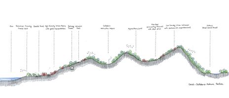 Section through Coast-Solfatara-Astroni

Green/blue infrastructure
As the European commission defines it, the Green Infrastructure represents a network of healthy ecosystems that often provides cost-effective alternatives to traditional 'grey' infrastructure and offers many other benefits for both EU citizens and biodiversity. Some of the main benefits provided by GI would be improved habitats for wildlife, ecological corridors and ladscape permeability. Society as a whole would be affected, not just the biodiversity if the natural powerhouses are damaged. In the study Green infrastructure is well represented in Astroni Natural Craters Reserve, which is included in the Natura 2000 network since 1995, under Birds Directive and Habitats Directive protecting 31 species and 2 habitats. The flora and fauna are very various, known as one of the richest places of Naples for birds diversity. Also inside the reservation the blue infrastructure is represented by three small lakes: Lago Grande, Cofaniello Grande and Confaniello Piccolo. Additionally it is important to mention the famous Solfatara in the northeast, a semiactive volcano that exhales sulfurous vapours and gives vent to liquid mud and hot mineral springs. Altough the study presents an important economic and touristic development, it’s essential to maintain the balance between nature and citizens. The underlying principle is that the same area of land can offer multiple benefits, if its ecosystems are in a healthy state, GI serving the interests of both people and nature.

Actors and stakeholders
- The first type of stakeholders is organizations and governmental associations in the area. The area is under the supervision of the municipality of Pozzuoli which is one of the main stakeholders with the high level of interest and the influences. The municipality of Pozzuoli is responsible for urbanistic plans and programs. The Superintendence for cultural heritage is the highest-ranked interest organization in the area that is caring for landscape and developing leisure and recreation of the area. Campania Region, as one of the stakeholders with a considerable level of interest, is planning for seashore protection and masterplan. Local people, tourists, investors, and businessman are considering as the second type of stakeholders. This type has a crucial role in the eco-social and environmental situation of the area. They can lead by the first group of the stakeholders to improve and promote the development factors of the area of the Pozzuoli.
-
 Power map

Sacred spaces and heritage
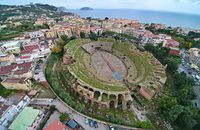
- The Flavian Amphitheater is the third largest Roman amphitheater in Italy. It was begun under the reign of the emperor Vespasian and probably finished under the reign of his son Titus. The arena can hold up to 50,000 spectators. The interior is mostly intact and one can still see parts of gears which were used to lift cages up to the arena floor. The site of the structure was chosen at the nearby crossing of roads from Naples, Capua and Cumae. It was abandoned when it was partially buried by eruptions from the Solfatara volcano. During the Middle Ages, the marble used on the exterior was stripped, but the interior was left alone and is perfectly preserved.
- The Temple of Serapis sits not far from the sea in the ancient town of Pozzuoli.It is not a temple at all, as its name would suggest, it is an important symbol of the region’s Roman roots, and more importantly, of the geologic forces at play in the Campi Flegrei. Serapis is the god of the underworld, as well as the god of the sun, healing, and fertility. Ptolemy I of Egypt created Serapis as an Egyptian-Greek god to unite the two cultures. Near the macellum there is that it lies about 30 feet below sea level. Its ancient granite columns seem to be suspended atop a mirky pool of water, leaving you with the impression that they are either rising up from or descending into the sea. Originally attributed to changes in sea level, geologists later learned that the ground was moving slowly up and down with the ebb and flow of magma chambers deep within the earth. From the Greek bradus, slow and sism movement, bradyseism is prevalent throughout the Campi Flegrei and the macellum is perhaps the most important example of it in the world. In fact, scientists have been documenting the ruins’ movements since the 18th century, when they found evidence of molluscs on several columns indicating that the columns were at one time submerged to a depth of at least 7 meters.
-
 Flavian Anphitheater - I century a.C.
 -
 The Temple of Serapis
 -
 Macellum (Serapis temple) I – II century a.C.


Visual appearance and landscape narrative
Solfatara make unique the city of Pozzuoli because of the underground process: its sulphurous soil, underground water, jets of steam who pierce the crust of earth, the tremble of ground and the hot mud who comes to the surface bubbling over. This area is permeated by the strong smell of sulphur, it looks like the gates of Hades. Rione Terra is the only part of Pozzuoli that has all the stratifications from greek period till now. Legends and miths are settled in this lands since Greeks and Romans. In the XVIII century when the Grand Tour spread all over Europe many artists such as Peter Fabris, Michele Mercati, Johannes Stradanus, Gaspar Van Wittel and Jakob Philip Hackert painted the magical athmosphere of Pozzuoli, Naples and Bay. This Vulcanic Land has inspired also well known poets from Omer, Horace, Vergilius and Boccaccio till Goethe, Madame De Stael.
- The first engraving above is an extraordinary proof of the expeditions of Sir William Hamilton by Peter Fabris. Hamilton is ambassador of the British Empire in Naples, a keen observer of local life and customs, as far as the scientific aspect is concerned. He has the task of informing British scholars about the activities of Vesuvius and Phlegraean Fields and the archaeological of Pompeii and Herculaneum. He visits the Solfatara of Pozzuoli even during eruptions to observe better the evolution. In this pictorial testimonies, Hamilton observes the gas fumes from a mouth of the Solfatara of Pozzuoli.
- The second engraving is from an original by Mercati. The beauty of the composition relies on the circular shape of the crater which, in reality, has a more irregular and elongated shape.
- The third picture instead, is Stradanus’s engraving who puts less emphasis on the composition and on the crater itself, but in his description is rich in dramatic in detail. Stradanus is particularly successful at depicting the light,the dirt at the centre of the crater and its quality, which is sandy at the top, and moving, almost fluid just below. He also situates the solfatara in its urban context
-
 Hamilton admires Solfatara, Peter Fabris
 -
 Solfatara of Pozzuoli from Michele Mercati's (1541-1593)
 -
 Detail from Solfatara, engraving by Johannes Stradanus (1523-1605)


A.2 Summary of you landscape system analysis and your development Targets
The Sustainable Development Goals are the blueprint to achieve a better and more sustainable future for all. Some of the goals targeted for 2030 for sustainable development are at risk in the area of Pozzouli-Solfatara-Astroni.
Promote inclusive and sustainable economic growth, employment and decent work for all, Goal 8: Sustainable economic growth will require societies to create the conditions that allow people to have quality jobs that stimulate the economy while not harming the environment.
Build resilient infrastructure, promote sustainable industrialization and foster innovation, Goal 9: We can upgrade infrastructure and retrofit industries to make them sustainable, with increased resource-use efficiency and greater adoption of clean and environmentally sound technologies. Also adaptive reuse of abandoned industries can ensure certain benefit.
Make cities inclusive, safe, resilient and sustainable, Goal 11: It is possible to strengthen our efforts to protect and safeguard cultural and natural heritage and providing universal access to safe, inclusive and accessible, green and public spaces.
Take urgent action to combat climate change and its impacts, Goal 13: Strengthening resilience and adaptive capacity to climate-related hazards and natural disasters is also required.
Conserve and sustainably use the oceans, seas and marine resources, Goal 14: We need to prevent and significantly reduce marine pollution from land-based activities, including marine debris and nutrient pollution. Also sustainably managing and protect marine and coastal ecosystems to avoid significant adverse impacts, including by strengthening their resilience, and take action for their restoration in order to achieve healthy and productive oceans.
Sustainably manage forests, combat desertification, halt and reverse land degradation, halt biodiversity loss, Goal 15: Ensuring the conservation, restoration and sustainable use of freshwater ecosystems and their services, in particular forests, wetlands and hilly areas in line with obligations under international agreements. Promoting the implementation of sustainable management of all types of forests, halt deforestation, restore degraded forests and substantially increase afforestation and reforestation is also necessary.
-
 DPSIR Framework is used for system analysis of the area. Population growth is recognized as a major driving force, which together with economic development puts pressures on the human and natural environment. As a consequence, there is landscape fragmentation, loss of natural and cultural heritage as well as deteriorated human wellbeing. A holistic approach to integrated development is a necessary response, which includes various steps for recognizing and conserving the values of the area.


At the current state the urban sprawl, fragmentation of landscapes and ecosystems and as well as the reduced quality of environment are leading the area to three main consequences: Loss of environmental and cultural heritage, biodiversity loss and also reduced quality of life for locals and a decreasing number of tourists. As a result of the rapidly urbanizing areas, agriculture intensifies on remaining undeveloped land and is likely to expand to new areas, putting pressure on land resources. The loss of biodiversity can be related to the antrophic activities. Humans have destroyed and continue to destroy the habitats of species on a daily basis.
A.3 Theory reflection
- UN HABITAT. New Urban Agenda: As the area characterized by rapid urbanization as the consequence of population growth, Puzzuoli coast is facing challenges such as Social (Migration), Climate change, Economic development, Demographic change, and Environment recourse management. The New Urban Agenda as guidance for further integrated urban development can facilitate mitigation of the problems such as urban sprawl, losing the identity of the space, unsustainable resource use and lack of participation, mainly through the dialog between multi-stakeholders (public and private sector, working with civil society).
- European Commission, The Multifunctionality of Green Infrastructure (GI), the functions of GI are described in terms of four broad roles as: protecting ecosystems state and biodiversity, improving ecosystem functioning and promoting ecosystem services, promoting societal wellbeing and health and supporting the development of a green economy, and sustainable land and water management. Some of the objectives of EU GI strategy for EU are to enhance, conserve and restore biodiversity by inter alia increasing spatial and functional connectivity between natural and semi-natural areas and improving landscape permeability and mitigating fragmentation, to enhance the societal and cultural link with nature and biodiversity, to acknowledge and increase the economic value of ecosystem services and to create incentives for local stakeholders and communities to deliver them, to minimise urban sprawl and its negative effects on biodiversity, ecosystem services in Europe. GI can be a highly effective policy tool since it can perform several functions at several scales, while taking into account the multiple connections and interactions which are so essential in nature. Benefits of GI include less grey infrastructure, more green jobs, more productive workforce, agriculture as well as increase in property values improving the quality of life.
- European Commission. Marine Strategy Framework Directive: The aim of the European Union’s ambitious Marine Strategy Framework Directive is to protect more effectively the marine environment across Europe. The european commission also produces a set of criteria and standards to help Member States to adopt this strategy.The aim is to achieve Good Environment Status (GES) by 2020,in order to protect marine resources. The Marine Strategy include the assessment of the current environmental status of marine waters and the impact of human activities.The climate changes can reduce the ability of an ecosystem to persist to other man-induced pressures. Impacts include rising sea levels, increased sea temperatures, precipitation changes, and ocean acidification.
A.4 References
- https://en.wikipedia.org/wiki/Economy_of_Naples, date 04.04.2019
- https://www.britannica.com/place/Pozzuoli, date 04.04.2019
- http://www.naplesldm.com/geology.php, date 04.04.2019
- https://www.google.com/maps, date 04.04.2019
- https://land.copernicus.eu/local/urban-atlas/urban-atlas-2012, date 04.04.2019
- https://land.copernicus.eu/pan-european/corine-land-cover, date 04.04.2019
- https://www.un.org/sustainabledevelopment/sustainable-development-goals/, date 04.04.2019
- https://www.academia.edu/12322699/Community_Supported_Agriculture_in_the_Urban_Fringe_Empirical_Evidence_for_Project_Feasibility_in_the_Metropolitan_Area_of_Naples_Italy_
- https://en.wikipedia.org/wiki/Pozzuoli, date 04.04.2019;
- https://en.wikipedia.org/wiki/Solfatara_(volcano), date 04.04.2019;
- http://eunis.eea.europa.eu/sites/IT8030007, date 04.04.2019;
- https://www.wwf.it/oasi/campania/cratere_degli_astroni/, date 04.04.2019;
- http://ec.europa.eu/environment/nature/ecosystems/index_en.htm, date 04.04.2019;
- Paolo Camilletti, Gianluca Lanzi, Natural and man-made landscape in the Phlegraean Fields: Linking identity and potentials for sustainable development. TRIA 20 (1/2018) 119-140/ e-ISSN 2281-4574. Accessed: 03.04.2019
- https://www.napoliunplugged.com/cratere-degli-astroni-nature-reserve.html, date 04.04.2019;
- http://ec.europa.eu/environment/nature/legislation/habitatsdirective/docs/Int_Manual_EU28.pdf, date 04.04.2019;
- https://www.eea.europa.eu/themes/landuse/land-cover-country-fact-sheets/it-italy-landcover-2012.pdf/view, date 04.04.2019;
- https://www.researchgate.net/publication/268096157_Coastal_Geomorphology_and_Sea-Level_Change, date 04.04.2019;
- https://urban.yale.edu/research/theme-4, date 04.04.2019;
- https://link.springer.com/article/10.1007/s12371-011-0033-1, date 04.04.2019;
- https://www.frontiersin.org/articles/10.3389/feart.2017.00072/full, date 04.04.2019;
- https://link.springer.com/article/10.1007/s12371-011-0033-1 , date 04.04.2019;
- https://www.researchgate.net/publication/320989930_Hydrothermal_activity_and_subsoil_complexity_implication_for_degassing_processes_at_Solfatara_crater_Campi_Flegrei_caldera, date 04.04.2019;
- https://www.vulcanosolfatara.it/en/, date 04.04.2019;
- https://www.wwf.it/oasi/campania/cratere_degli_astroni/cratere_degli_astroni__english_version_.cfm, date 04.04.2019;
Phase B: Landscape Evaluation and Assessment
All the resources that we have in this area must be well evaluated and proposed conservation strategies. The strategy helps in future planning of the territory’s open spaces, urban areas, riverine corridors, beach zones and nature reserves. The main goals for the assessment that we need to consider can be short-term or long-term, positive or negative, and may include: traffic,infrastructure capacity, heritage or streetscape character, land stability, biodiversity, people communities. So, the main issues for our assessment are:
- improving the transport system, for increasing transport efficiency;
- evaluation of ecological and cultural hotspots, because there is an emerging recognition that the diversity of life comprises both biological and cultural diversity;
- protecting of green and blue areas, because they represent a combination of important ecosystems that provide habitat for many species, regular water-cycles and clean air.
B.2 Mapping
-
 Mapping 1, Evaluation of Transportation Infrastructure: Public transportation in the site is good towards the coastal area with metro and underground subway and metro stations are placed in a good distance interval to become accessible for the public and tourists. However universal accessibility towards beach should be a consideration. Towards north the public transportation is available but more time consuming taking long routes and change of vehicles, for example if a tourist want to go from Solfatara to Astroni, he needs to first take a metro and then he has to take another bus and finally he has to walk around 40 minutes more to reach Astroni which will take altogether around 2 hrs. Also there is no bike route available now could be cause of the hilly areas. If the tourist takes walking route it will take a bit more than an hour to reach Astroni from Solfatara, though it has some private or restricted properties on the way at present.So walking route through green corridors of agriculture and pasture lands and improving pedestrian connections as well as the public transportation especially in the north Solfatara-Astroni side could enhance the accessibility to various hotspots of the site to promote tourism.
 -
 Mapping 2, Cultural and ecological hotspots has been performed in order to recognize points of interest for locals and visitos. However, not all of these hotspots have the same value. Acording to information and ratings found on the Internet, these spots are on different levels, depending on the quality of maintance, popularity, accessibility and the level of appreciation by locals and tourists. These levels will need to be reevaluated when combined with other maps in order to discover most suitable areas for developing the the green-blue infrastructure.
 -
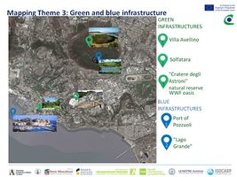 Mapping 3, Green and blue infrastructure: In Astroni Solfatara territory we have a different green areas. Villa Avellino is a Roman architecture and it is built in 1540 by the princes Colonna di Stigliano. The Villa Avellino's park is the Pozzuoli's Park between the nature of the garden and the history of the city. The private garden of the Villa was given at municipality of pozzuoli in 1980 and that is a most famous green park. The Phlegraean Fields Regional Natural Park includes the Solfatara, the archaeological sites of Pozzuoli, Cuma and Baia, the naturalistic oases of the Astroni and Monte Nuovo craters, and the Averno, Lucrino and Fusaro lakes, all of volcanic origin. It is an extraordinary Park with an enormous landscape, environmental and archaeological value. The most important green area is the one of the Astroni Crater Nature Reserve, a royal hunting estate in the Aragonese and later Bourbon periods. It is a WWF-protected Oasis located within one of the Phlegraean craters, a volcanic area. The Crater dates back to around 4,000 years ago and was called by the Romans Forum Vulcani ("home of the volcano god"). In the Astroni Crater we can find Lago Grande, a lake with volcanic origins, is the largest of the 3 bodies of water present in the Reserve. In the lake there is a floating island formed by a lake nature that moves a second of the wind direction. The shores of the lake are covered by the white water lily, a deciduous plant introduced by Giovanni Gussone, a botanist from the Bourbon court, towards the middle of the 1800s. The other attractive is porto of Pozzuoli.'


The potential risks could be represented in the Ishikawa diagram, which is based on the cause effect analysis. The main causes are anthropic or natural. The anthropic causes are represented by human activities, such as intensive agriculture which could lead to a significant biodiversity loss because of the amount of fertilizers and pesticides used. Another effect from intensive agriculture on undeveloped land could be pressures on land resources. As for the urban growth, the main effect would be the loss of environmental and cultural heritage. From land conversion it could result in habitat fragmentation and ecosystem decay. Possible natural causes are the rising sea levels and volcanic eruptions (e.g Campi Flegrei). The first one could lead to devastating effects on coastal habitats, farther in land causing destructive erosion, wetland flooding and habitat loss for many different species. The second one can be considered as a natural disaster – the effects from this one leading to destructive flooding of the shoreline and also it affects the natural sceneries.

B.4 Theory reflection
- Environmental Impact Assessment of Projects- Guidance on the preparation of the Environmental Impact Assessment Report
This guidance document is one in a series of three Guidance Documents on EIA (Environmental Assessment of Projects) that has been published by the European Commission. EIA of projects is an instrument of European Union environmental policy. The aim of the Guidance Documents is to provide practical insight to all the actors involved during these stages in the EIA process. They are designed for use by competent authorities, developers, and EIA practitioners in the European Union Member States and, where applicable, by candidate countries.
The EIA report’s content requirements are: project description, the starting point of EIA is the Baseline assessment (the Baseline scenario and its assessment provide a description of the affected environment as it is currently, and as it could be expected to develop if the project were not to proceed), environmental factors, assessing effects on the environment, mandatory assessment of alternatives, mitigation and compensation measures and finally, monitoring. EIA is linked to other EU instruments such as SEA Directive, Water Framework Directive, Waste Framework Directive, etc. and other guidance and tools.
This guidance is relevant to our case study due to providing an instrument that is well structured. It also brings into discussion the impact of the project on all the layers of a territory, helping in the decision making process.
- The Guidance note Coastal Character Assessment
This guidance has been produced to aid the production of coastal character assessments. The method is linked to landscape character assessment but considers those additional specific characteristics associated with the coast. Local Coastal Character Areas are smaller in size and characterised by a finer level of detail and they further subdivide the Regional Character Area into areas of consistent coastal character with a strong integrity, like a specific bay, section of coast with a similar character. Areas of distinct character can be defined on the basis of physical landform, degree of enclosure or openness and an assessment of horizontal and vertical scale; degree of influence of the sea and maritime qualities on both landscape and coast of the area, including coastal dynamics; shape, scale and degree of fragmentation of the coastline; presence of human artefacts, distribution of settlement pattern and amount of human activity; landscape features, including historic features and their setting; experience of the coast, landscape and seascape, including degree of remoteness and potential opportunity to appreciate wildness. Checklists for establishing coastal character and visual character can be made including relevant consideration and recognized values focusing on: • Maritime influences and experience from the sea, • Character of the coastal edge and its immediate hinterland, • Extent of human activity, and • Views and visibility (visual assessment).
- Limitations/ difficulties (assessment and evaluation):
- Identifying the way economy, tourism and nature mix and interact in the present time (positive and negative aspects).
- Finding the landscape “calling” and purpose in the local and regional picture.
- Choosing the goals that will support the development in the close future, but will not lead to degradation of the environmental and natural values found in the Pozzuoli-Solfatara-Astroni area.
B.5 References
- http://ec.europa.eu/environment/eia/pdf/EIA_guidance_EIA_report_final.pdf, date 02.05.2019
- http://ec.europa.eu/environment/eia/eia-support.htm, date 02.05.2019
Phase C – Strategy and Master Plan
C.1 Goal Setting
Sustainable Tourism Development
One of the goals to be achieved could be Sustainable tourism, that can be defined as: "Tourism that takes full account of its current and future economic, social and environmental impacts, addressing the needs of visitors, the industry, the environment and host communities"
Thus sustainable tourism will
-Make optimal use of environmental resources that constitute a key element in tourism development, maintaining essential ecological processes and helping to conserve natural heritage and biodiversity. (supporting Goal 15 LIFE ON LAND)
-Respect the socio-cultural authenticity of host communities, conserve their built and living cultural heritage and traditional values, and contribute to inter-cultural understanding and tolerance. (supporting Goal 11 SUSTAINABLE CITIES AND COMMUNITIES)
-Ensure viable, long-term economic operations, providing socio-economic benefits to all stakeholders that are fairly distributed, including stable employment and income-earning opportunities and social services to host communities, and contributing to poverty alleviation. ( supporting Goal 8 ECONOMIC GROWTH)
C.2 Spatial Strategy and Transect
-
 Draft Strategy Tree
 -
 Vision map
 -
 Transect map
 -
 Conceptual sketch interventions


C.3 From Theory of Change to Implementation
•Partnerships needed are local and regional administration, private investors as well as local people.
•Tourism stakeholders should participate in public-private partnerships for a sustainable tourism development of urban destinations. For sustainable tourism development the administration should associate global organisations, for example The Global Partnership for Sustainable Tourism,an organizational network of tourism stakeholders of the public and private sectors, non-profits.
•A key objective of the Global Partnership is to provide guidance for developing sustainable tourism projects, promote sharing of best practices and encourage reporting of demonstrable results.
Partner organizations share the common vision and understanding of the goal of sustainable tourism and collaborate internationally, regionally or nationally to transform tourism globally.
-
 Timeline- steps to achieve our goal
 -
 An evolutionary model of tourism partnership
 -
 Research- Planning- Implementation- Beneffits


C.4 References
- https://www.researchgate.net/figure/Tourism-partnership-model-Source-Selin-and-Chavez-1995-848_fig1_306136833 , date 30.05.2019
- https://sustainabledevelopment.un.org/partnership/?p=7411 , date 30.05.2019
- https://www.slideshare.net/reymarieoohlala/sustainable-tourism-development , date 30.05.2019
- https://www.slideshare.net/JamesMacGregor/nyu-presentation-ver-a , date 30.05.2019
- https://sdt.unwto.org/content/about-us-5 , date 29.05.2019
D. Process Reflection
Reflecting back about the experience, this activity contributed to the development of our knowledge, skills and professional behavior. The most challenging part was the communication, language differences, professional terms, but in the end we managed to outcome it, and started to enjoy the debates. Generating a broad array of possible alternative points of view or solution to a problem. This way we learned from each other something: how to organize better, divide a complex problem, process of thinking, see the bigger image or pay attention to the details. We also needed to approach the same graphic language, this was difficult but we also learned different type of representation.
For our team it was a great experience. We would not change much, but for sure we would like if we had more debates and more active communication.
-
 Critical thinking, source http://shutterstock.com
