Nile Delta: Difference between revisions
Created page with "'''>>>back to working groups overview''' <div id="BackToTop" class="noprint" style="background-color:#DDEFDD; position:fixed;..." |
|||
| (47 intermediate revisions by the same user not shown) | |||
| Line 9: | Line 9: | ||
{| align="right" width="400pt" style="background:Gainsboro; color:black" | {| align="right" width="400pt" style="background:Gainsboro; color:black" | ||
|- | |- | ||
| '''Area''' ||style="background:Lavender"| '' | | '''Area''' ||style="background:Lavender"| ''Nile delta'' | ||
|- | |- | ||
| '''Place''' || style="background:Lavender"|'' | | '''Place''' || style="background:Lavender"|''North of Egypt'' | ||
|- | |- | ||
| '''Country''' || style="background:Lavender"|'' | | '''Country''' || style="background:Lavender"|''Egypt'' | ||
|- | |- | ||
| '''Topics''' || style="background:Lavender"|'' | | '''Topics''' || style="background:Lavender"|''Tourism and nature protection'' | ||
|- | |- | ||
| '''Author(s)''' || style="background:Lavender"|'' | | '''Author(s)''' || style="background:Lavender"|''Ahmed kamal'' | ||
|- | |- | ||
| colspan="3" align="center" style="background:silver"| [[File: | | colspan="3" align="center" style="background:silver"| [[File:Nile_delta_location.jpeg|400px]] | ||
|- | |- | ||
| ||style="background:Lavender"| | | ||style="background:Lavender"| | ||
| Line 27: | Line 27: | ||
= Rationale = | = Rationale = | ||
*'' | *''Nile delta is the breadbasket of Egypt, 2\3 of the agriculture products comes from this area supporting 40 million of people and considering one of the best regions for agriculture in Egypt due to its location on the Midetterian sea besides two branches of Nile river in the lower part in Egypt which consider the source of water in these region. the coastline of Nile delta from Port said city to Alexandria city consider one of the most vulnerable coastlines in the world facing the problem of coastal erosion and rising sea level due to its lower elevation. | ||
= Location and scope = | = Location and scope = | ||
''You can edit this map with the [[Special:MapEditor|map editor]]'' | ''You can edit this map with the [[Special:MapEditor|map editor]]'' | ||
{{#display_map: | {{#display_map: 31.551428394344708,30.85032247829281~Nile delta | ||
}} | }} | ||
| Line 40: | Line 39: | ||
== A.1 Landscape layers and their system context == | == A.1 Landscape layers and their system context == | ||
=== Geomorphology, landscape units and coastal typology === | === Geomorphology, landscape units and coastal typology === | ||
* | * The Nile delta is formed by the two branches of Nile river in the lower part in Egypt. It spread out to V shape fan due to the Nile flood in the past before the high dam constructed in the upper part of the Nile. The construction of the high dam limited the Nile river to two branches (Rashid branch on the west and Dumyat branch on the east) | ||
* | * | ||
<gallery caption=" " widths="200px" heights="150px" perrow="5"> | <gallery caption=" " widths="200px" heights="150px" perrow="5"> | ||
File: | File:Geomorphology Nile delta.jpeg|''Abstract analysis map'' | ||
File: | File:Nile-Delta-Topography-map.jpg|''Topography map'' | ||
</gallery> | </gallery> | ||
=== Land use === | === Land use === | ||
* | * The Nile delta coastline begins from the east in Port said city which consider a big harbour located at the sea and very dense settlement to Alexandria city in the west which consider residential and recreational area all the year. The area between them very diverse between the agriculture fields due to the Nile river and, fishing farms, three big sea lagoons (Idku, lake Burulls and lake Manzella ) produce 60% of the fish catch beside small urban cities.The most activities in this area are fishing, agriculture and tourism. too many agriculture areas near the coast not suitable for cultivating and the function changed to fishing farm because the soil becomes salinity. | ||
<gallery caption=" " widths="200px" heights="150px" perrow="5"> | <gallery caption=" " widths="200px" heights="150px" perrow="5"> | ||
File: | File:Nile_delta_land_use.jpeg|''Landuse map (by the author)'' | ||
File: | File:Nile delta typology.jpeg|''Typology of coastline (by the author)'' | ||
File: | File:Alexandria.jpeg|''Alexandria city (west side of delta)'' | ||
File:Port said.jpeg|''Port said city (East side of delta)'' | |||
File:Ras_el_bar_city.jpeg|''Ras el bar city (Resedential and recreational area)'' | |||
File:River and the sea.jpeg|''Nile river at the right and the sea in the left'' | |||
</gallery> | </gallery> | ||
=== Green/blue infrastructure === | === Green/blue infrastructure === | ||
* | * The green and blue infrastructure very diverse in this area and the most dominant element is the agriculture area also you can find too many meadows and the contrast between the two Nile branches and the 3 lakes along the mediterranean sea. All of this elements consider great elements to connect all of this separated area to increase the high value of aesthetic value and give the people the opportunity to interact with nature and increase the biodiversity besides that | ||
<gallery caption=" " widths="200px" heights="150px" perrow="5"> | <gallery caption=" " widths="200px" heights="150px" perrow="5"> | ||
File: | File:Nile_delta_GI.jpeg|''Green infrastructure (by the author)'' | ||
File:your case_green blue infrastructure2.jpg|''add a caption'' | File:your case_green blue infrastructure2.jpg|''add a caption'' | ||
</gallery> | </gallery> | ||
| Line 73: | Line 70: | ||
* ''Draw a stakeholder and/or power map: Who is affected highly but with low power? Who has high power but is not affected?'' | * ''Draw a stakeholder and/or power map: Who is affected highly but with low power? Who has high power but is not affected?'' | ||
<gallery caption=" " widths="500px" heights="200px" perrow="5"> | <gallery caption=" " widths="500px" heights="200px" perrow="5"> | ||
File: | File:Nile delta Power map.jpg|''Power map edited by the author'' | ||
</gallery> | </gallery> | ||
=== Sacred spaces and heritage === | === Sacred spaces and heritage === | ||
* | * stanley bridge in Alexandria city crossing the mediterranean sea one of the most beautiful bridge in the city due to the unique character and the aesthetics value for this place as it considers landmark for the city. | ||
* | the other site is the administration building of canal el Suez one of the most important projects in Egypt that connected the mediterranean sea and the red sea. this building constructed in the 18th century. | ||
* | |||
<gallery caption=" " widths="200px" heights="150px" perrow="5"> | <gallery caption=" " widths="200px" heights="150px" perrow="5"> | ||
File: | File:Stanley bridge.jpg|''Stanley bridge in alexandria (west delta)'' | ||
File: | File:Suez canal adminstration building.jpeg|''Suez canal adminstration building'' | ||
File: | File:Suez canal.jpg|''Suez canal construction'' | ||
</gallery> | </gallery> | ||
=== Visual appearance and landscape narrative === | === Visual appearance and landscape narrative === | ||
* | * the landscape parks along the Meditteranean sea play an important role in people life. It is the green heart of the city. One of this parks is Montaza palace and its gardens as it considers one of the most beautiful parks in Alexandria city as a recreational area and historical area also. The aesthetics value of this area is very high due to the beauty, The character and diversity of green spaces. | ||
<gallery caption=" " widths="200px" heights="150px" perrow="5"> | <gallery caption=" " widths="200px" heights="150px" perrow="5"> | ||
File: | File:Montaza park.jpg|''Montaza palace and gardens in alexandria (west delta)'' | ||
File: | File:Montaza 3.jpg|''Montaza gardens (alexandria city)'' | ||
File:your case_character3.jpg|''add a caption'' | File:your case_character3.jpg|''add a caption'' | ||
</gallery> | </gallery> | ||
| Line 107: | Line 102: | ||
<gallery caption=" " widths="500px" heights="200px" perrow="5"> | <gallery caption=" " widths="500px" heights="200px" perrow="5"> | ||
File: | File:Nile delta Dpsir.jpg|''In the Nile delta there are too many drivers affect this area such as; Agriculture, Urbanization, Tourism and fishing industry and all of these drivers put pressure on the existing water resources because Egypt nowadays suffering from the water capacity also the environment will affect from the grey structure and the negative effects from climate and the decrease of biodiversity in this area '' | ||
</gallery> | </gallery> | ||
<gallery caption=" " widths="500px" heights="200px" perrow="5"> | <gallery caption=" " widths="500px" heights="200px" perrow="5"> | ||
File: | File:Nile delta Hypothesis.jpg|''we assume if the water level will increase 50cm 4 million people will suffer from this problem and we will lose 1800 km2 from the agriculture area but if the water level increase 1.50m 8 million people will suffer from this problem and we will lose 5000 km2 from agriculture area and the Nile delta is the main source of water and fish stock so the climate change will affect not only the environment but the local citizens also '' | ||
</gallery> | </gallery> | ||
== A.3 Theory reflection == | == A.3 Theory reflection == | ||
* | * https://publications.europa.eu/en/publication-detail/-/publication/738d80bb-7d10-47bc-b131-ba8110e7c2d6 | ||
*The green infrastructure plays an important role in human life .It maintaining the outside environment from the negative effects that happens from human grey structure and climate change negative effects .By investing in GI we will gain too many benefits at different levels environmentally, Socially and economy also. Regarding the environment it improves the quality of air and water ,Protecting from soil erosion that could happen and mitigate heat island instead of using air conditioning and save energy . On the other hand there are too many benefits for human by creating new jobs for engineers and planners and connect the people more with nature also it increase the local income through recreation and tourism by focusing on the aesthetics value and improve the overall image for the city. | |||
There are too potential possibility to invest in GI by connecting separate green areas through eco-corridors, green bridges and tunnels under the roads to improve the mobility of wild life to protect different species , Installing green roofs, green walls at building, Dense plantation inside the cities,creating buffer zones and use the nature to avoid the erosion, install plantation in coastal lines,It is not only help in increasing the biodiversity it also mitigate the heat island and the negative effects from climate change. | |||
The European union knows well the great benefits from investing in GI. So they trying to put the framework to connect the European countries through nature for example through project 2000 agreement which consider developing the whole protected area in Europe and find the possibilities to develop that. | |||
== A.4 References == | == A.4 References == | ||
* | * http://www.ipsnews.net/2014/01/nile-delta-disappearing-beneath-sea/ | ||
* https://www.theguardian.com/environment/2009/aug/21/climate-change-nile-flooding-farming | |||
* https://www.witpress.com/Secure/elibrary/papers/CP11/CP11004FU1.pdf | |||
* http://www.grida.no/resources/5629 | |||
= Phase B: Landscape Evaluation and Assessment = | = Phase B: Landscape Evaluation and Assessment = | ||
== B.1 Assessment Strategy == | == B.1 Assessment Strategy == | ||
* | * The Nile delta faces too many pressures on this area such as; The salinity of soil, water pollution, soil erosion and dense population but the major problem is the pressure on the agriculture especially the urban sprawl on the delta area and it is very important to evaluate these theme through the changes from 1882 to 2006 because in these dates too many changes happened on the delta area and has its negative impact on the agri-ecosystems, the surrounding landscape and the social and health problems. | ||
the second theme is the negative impact on rising sea level and we give full image of the relationship between rising sea level and coastal erosion because also this problem will seriously affect the 4 biggest cities on the mediterranean sea and its negative effect on the agriculture land, soil erosion, socio-economic problems and loss of productive lands. | |||
This problem will affect 20 percent of the deltic area especially the west of Delta because the most of this area below the sea level and 13% of the delta land lies between 1.00 and 2.00 m. | |||
== B.2 Mapping == | == B.2 Mapping == | ||
| Line 134: | Line 133: | ||
<gallery caption=" " widths="500px" heights="200px" perrow="1"> | <gallery caption=" " widths="500px" heights="200px" perrow="1"> | ||
File: | File: Urban sprawl 1.jpg|''Using the gis system using the built-up area changes from 1884 to 2006 and soil map. We get the final output from GIS shows the assessment of the soil to five categories depends on the quality of soil and built up areas in 3 dates from 1884 to 2006 '' | ||
File: | File: Urban sprawl 2.jpg|''We find that the built-up area increased very high especially from 1992 to 2006 due to many reasons such as social and economic reasons that cause too many problems and huge pressure on the agriculture land '' | ||
File: | File: Rise sea level.jpg|'' this maps shows the relation of rising sea level on the delta area in the current situation and 1.00, 2.00 m high and the population map shows the density of people different regions in the delta '' | ||
File: Rise sea level 2.jpg|''we find that the huge negative effects on productive agriculture land, the negative effects on the 4 biggest cities on the mediterranean sea and the people in this cities will be forced to abandon their settlement to the south and the coastal defences are not enough in all of this areas '' | |||
</gallery> | </gallery> | ||
| Line 145: | Line 145: | ||
<gallery caption=" " widths="500px" heights="200px" perrow="5"> | <gallery caption=" " widths="500px" heights="200px" perrow="5"> | ||
File: | File:Potential 1.jpg|''The north area of the delta faces too many problems and the high diversity of this area that contains too many elements such as; the coastal area, agriculture lands, the 4 lagoons on the sea, the biggest 4 cities, protective area , flora and fauna, huge aesthetic value due to the historical elements and the two branches of Nile river '' | ||
File: Potential 2.jpg|''The main strategy of development is to protect, restore and enhance the Delta ecosystem services '' | |||
</gallery> | </gallery> | ||
== B.4 Theory reflection == | == B.4 Theory reflection == | ||
* | *Online sources are quiet limited especially in GIS maps and data, So it is so important to make assessment for aesthetics value in the Nile delta and evaluate the culture landscapes which consider one of the main core in ecosystem services to give full image before starting putting scenarios and master plans to develop the area of Nile delta. | ||
== B.5 References == | == B.5 References == | ||
* | * http://egeoscien.neigae.ac.cn/fileup/PDF/20150302.pdf | ||
https://www.researchgate.net/publication/273767898_NILE_DELTA_CHALLENGES_AND_OPPORTUNITIES_A_STATE_OF_THE_ART_REVIEW | |||
http://egeoscien.neigae.ac.cn/fileup/PDF/20150302.pdf | |||
https://www.theguardian.com/environment/2009/aug/21/climate-change-nile-flooding-farming | |||
=Phase C – Strategy and Master Plan = | =Phase C – Strategy and Master Plan = | ||
== C.1 Goal Setting == | == C.1 Goal Setting == | ||
In my landscape assessment I explain about the issue of urban growth and the dense population in one of the most beautiful area in Egypt surrounded by high diversity of landscape elements between meadow, allotment gardens,Huge agriculture lands, the Nile river and the Mediterranean sea. The urban sprawl causes huge pressure on the area So i translated my assessment to main essential goals support the local citizens such as; | |||
1-Enhance and develop the existing infrastructure especially inside the dense settlement | |||
2-Improve the Health of local people and create better environment. | |||
3-Improve the local economy by changing the landuse in term of the concept of green infrastructure. | |||
4-Create more jobs for the local citizens. | |||
5-Enhance and protect the ecosystem services in the deltic area. | |||
6-Increase the bio diversity. | |||
7-Sustainable green cities to meet the needs of different people. | |||
and all of this goals took into consideration in the overall concept plan to turn to the sustainable development. | |||
== C.2 Spatial Strategy and Transect == | == C.2 Spatial Strategy and Transect == | ||
| Line 169: | Line 177: | ||
<gallery caption=" " widths="500px" heights="200px" perrow="1"> | <gallery caption=" " widths="500px" heights="200px" perrow="1"> | ||
File: | File:Ma1.jpeg|''google image shows the Study area at the left side of nile river '' | ||
File: | File:Ma2.jpeg|''sketch shows the Study area at the left side of nile river'' | ||
File: | File:Ma3.jpeg|''Overall concept'' | ||
File: | File:Ma4.jpeg|''transect method'' | ||
File:Ma12.jpeg|''visualizations1'' | |||
File:Ma14.jpeg|''visualizations2'' | |||
</gallery> | </gallery> | ||
== C.3 From Theory of Change to Implementation == | == C.3 From Theory of Change to Implementation == | ||
*'' | |||
*''Deltic area is complex area since it has too many pressure on it from urban growth, pollution, loss of agriculture lands and coastal area challenges and economy as well so it is important to different partner such as, the government which consider the main support, also to deal with investors to find the potential investment in many fields as well as the community who care about their environment . | |||
There are too many actions should be taken to complete this vision and the master plan should reflect meets the needs of different kind of people and interests. And to reach our goals we should focus on putting time line as a short term and medium and long term plan , the importance of including the community in the design process and increase the environmental knowledge and explain the whole situation is the key of the success .Enhancing and creating better environment for the local citizen is the main aim of my concept and this will not happen without different kind of resources and strong economy.'' | |||
<gallery caption=" " widths="500px" heights="200px" perrow="1"> | <gallery caption=" " widths="500px" heights="200px" perrow="1"> | ||
File: | File:Ma9.jpeg|''governance model and partnership'' | ||
File: | File:M11.jpeg|''transect method'' | ||
</gallery> | </gallery> | ||
== C.4 References == | == C.4 References == | ||
file:///C:/Users/TS-03/Downloads/Cardiff%202025%20Chap%2011%20(1).pdf | |||
file:///C:/Users/TS-03/Downloads/Cardiff%202025%20Chap%2013%20(2).pdf | |||
http://www.eg.undp.org/content/egypt/en/home/operations/projects/climate-and-disaster-resilience/project_sample1.html | |||
https://www.sciencedirect.com/science/article/pii/S1110016815002112 | |||
= D. Process Reflection = | = D. Process Reflection = | ||
| Line 196: | Line 213: | ||
*''You can also use diagrams/visuals'' | *''You can also use diagrams/visuals'' | ||
*''250 words text'' | *''250 words text'' | ||
Since i worked alone in this seminar. So i didn't get the chance to get more ideas about the site so I depend on what I learned from the online seminars, readings and searching in the internet As I saw too many useful different topics related to the coastal landscapes that this problem is a global challenge affects different areas around the world and the negative effects of it will affect the local people, environment, economy and tourism industry. | |||
The importance of understanding the problem is the first step in this project. By enhancing and protecting the ecosystem services in this area is very important because the environment support us with different kind of benefits such as provisioning services, regulating the environment and the aesthetics value of it. So it is very important to asses the Existing ecosystem services in this area. | |||
Also by focus on the investing in green infrastructure we can gain huge benefits from it and create more jobs which increase the local income and create better environment for the health of local people | |||
The design should also meets different kind of people and interests. | |||
I faced also too many limitation such as; Site visiting, getting Gis maps and data, studies about the aesthetics values in this area, and the time also is not enough for putting the concept plan and more assessment for the area. | |||
Latest revision as of 09:45, 19 June 2018
>>>back to working groups overview
| Area | Nile delta | |
| Place | North of Egypt | |
| Country | Egypt | |
| Topics | Tourism and nature protection | |
| Author(s) | Ahmed kamal | |

| ||
Rationale
- Nile delta is the breadbasket of Egypt, 2\3 of the agriculture products comes from this area supporting 40 million of people and considering one of the best regions for agriculture in Egypt due to its location on the Midetterian sea besides two branches of Nile river in the lower part in Egypt which consider the source of water in these region. the coastline of Nile delta from Port said city to Alexandria city consider one of the most vulnerable coastlines in the world facing the problem of coastal erosion and rising sea level due to its lower elevation.
Location and scope
You can edit this map with the map editor
A Landscape System Analysis
A.1 Landscape layers and their system context
Geomorphology, landscape units and coastal typology
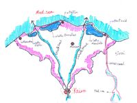
- The Nile delta is formed by the two branches of Nile river in the lower part in Egypt. It spread out to V shape fan due to the Nile flood in the past before the high dam constructed in the upper part of the Nile. The construction of the high dam limited the Nile river to two branches (Rashid branch on the west and Dumyat branch on the east)
-
 Abstract analysis map
 -
 Topography map


Land use
- The Nile delta coastline begins from the east in Port said city which consider a big harbour located at the sea and very dense settlement to Alexandria city in the west which consider residential and recreational area all the year. The area between them very diverse between the agriculture fields due to the Nile river and, fishing farms, three big sea lagoons (Idku, lake Burulls and lake Manzella ) produce 60% of the fish catch beside small urban cities.The most activities in this area are fishing, agriculture and tourism. too many agriculture areas near the coast not suitable for cultivating and the function changed to fishing farm because the soil becomes salinity.
-
 Landuse map (by the author)
 -
 Typology of coastline (by the author)
 -
 Alexandria city (west side of delta)
 -
 Port said city (East side of delta)
 -
 Ras el bar city (Resedential and recreational area)
 -
 Nile river at the right and the sea in the left


Green/blue infrastructure
- The green and blue infrastructure very diverse in this area and the most dominant element is the agriculture area also you can find too many meadows and the contrast between the two Nile branches and the 3 lakes along the mediterranean sea. All of this elements consider great elements to connect all of this separated area to increase the high value of aesthetic value and give the people the opportunity to interact with nature and increase the biodiversity besides that
-
 Green infrastructure (by the author)
 -
add a caption

Actors and stakeholders
- Who is driving changes in this landscape? Who is affected by those changes?
- Draw a stakeholder and/or power map: Who is affected highly but with low power? Who has high power but is not affected?
-
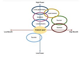 Power map edited by the author

Sacred spaces and heritage
- stanley bridge in Alexandria city crossing the mediterranean sea one of the most beautiful bridge in the city due to the unique character and the aesthetics value for this place as it considers landmark for the city.
the other site is the administration building of canal el Suez one of the most important projects in Egypt that connected the mediterranean sea and the red sea. this building constructed in the 18th century.
-
 Stanley bridge in alexandria (west delta)
 -
 Suez canal adminstration building
 -
 Suez canal construction


Visual appearance and landscape narrative
- the landscape parks along the Meditteranean sea play an important role in people life. It is the green heart of the city. One of this parks is Montaza palace and its gardens as it considers one of the most beautiful parks in Alexandria city as a recreational area and historical area also. The aesthetics value of this area is very high due to the beauty, The character and diversity of green spaces.
-
 Montaza palace and gardens in alexandria (west delta)
 -
 Montaza gardens (alexandria city)
 -
add a caption


A.2 Summary of you landscape system analysis and your development Targets
- You can summarize your findings with an DPSI(R) Model or a Spider Diagram
- Link back to the Sustainable Development Goals: Which goals are at risk?
- What is your hypothesis for this landscape?
- Visualise your hypothesis with one graphic/pict
- Are there any existing initiatives taking action in this landscape? Do you have a critical perspective on that?
- Add text and visuals
-
 In the Nile delta there are too many drivers affect this area such as; Agriculture, Urbanization, Tourism and fishing industry and all of these drivers put pressure on the existing water resources because Egypt nowadays suffering from the water capacity also the environment will affect from the grey structure and the negative effects from climate and the decrease of biodiversity in this area

-
 we assume if the water level will increase 50cm 4 million people will suffer from this problem and we will lose 1800 km2 from the agriculture area but if the water level increase 1.50m 8 million people will suffer from this problem and we will lose 5000 km2 from agriculture area and the Nile delta is the main source of water and fish stock so the climate change will affect not only the environment but the local citizens also

A.3 Theory reflection
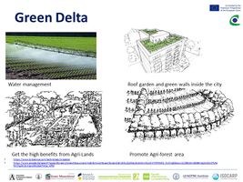
- The green infrastructure plays an important role in human life .It maintaining the outside environment from the negative effects that happens from human grey structure and climate change negative effects .By investing in GI we will gain too many benefits at different levels environmentally, Socially and economy also. Regarding the environment it improves the quality of air and water ,Protecting from soil erosion that could happen and mitigate heat island instead of using air conditioning and save energy . On the other hand there are too many benefits for human by creating new jobs for engineers and planners and connect the people more with nature also it increase the local income through recreation and tourism by focusing on the aesthetics value and improve the overall image for the city.
There are too potential possibility to invest in GI by connecting separate green areas through eco-corridors, green bridges and tunnels under the roads to improve the mobility of wild life to protect different species , Installing green roofs, green walls at building, Dense plantation inside the cities,creating buffer zones and use the nature to avoid the erosion, install plantation in coastal lines,It is not only help in increasing the biodiversity it also mitigate the heat island and the negative effects from climate change. The European union knows well the great benefits from investing in GI. So they trying to put the framework to connect the European countries through nature for example through project 2000 agreement which consider developing the whole protected area in Europe and find the possibilities to develop that.
A.4 References
- http://www.ipsnews.net/2014/01/nile-delta-disappearing-beneath-sea/
- https://www.theguardian.com/environment/2009/aug/21/climate-change-nile-flooding-farming
- https://www.witpress.com/Secure/elibrary/papers/CP11/CP11004FU1.pdf
- http://www.grida.no/resources/5629
Phase B: Landscape Evaluation and Assessment
B.1 Assessment Strategy
- The Nile delta faces too many pressures on this area such as; The salinity of soil, water pollution, soil erosion and dense population but the major problem is the pressure on the agriculture especially the urban sprawl on the delta area and it is very important to evaluate these theme through the changes from 1882 to 2006 because in these dates too many changes happened on the delta area and has its negative impact on the agri-ecosystems, the surrounding landscape and the social and health problems.
the second theme is the negative impact on rising sea level and we give full image of the relationship between rising sea level and coastal erosion because also this problem will seriously affect the 4 biggest cities on the mediterranean sea and its negative effect on the agriculture land, soil erosion, socio-economic problems and loss of productive lands. This problem will affect 20 percent of the deltic area especially the west of Delta because the most of this area below the sea level and 13% of the delta land lies between 1.00 and 2.00 m.
B.2 Mapping
- As defined by your assessment strategy you conduct the mapping and present your findings here
- As a minimum, at least three different themes need to be mapped, you may choose more if needed
-
 Using the gis system using the built-up area changes from 1884 to 2006 and soil map. We get the final output from GIS shows the assessment of the soil to five categories depends on the quality of soil and built up areas in 3 dates from 1884 to 2006
 -
 We find that the built-up area increased very high especially from 1992 to 2006 due to many reasons such as social and economic reasons that cause too many problems and huge pressure on the agriculture land
 -
 this maps shows the relation of rising sea level on the delta area in the current situation and 1.00, 2.00 m high and the population map shows the density of people different regions in the delta
 -
 we find that the huge negative effects on productive agriculture land, the negative effects on the 4 biggest cities on the mediterranean sea and the people in this cities will be forced to abandon their settlement to the south and the coastal defences are not enough in all of this areas


B.3 Problem definition and priority setting
- Give a summary of the major findings of your mapping process, what are the problems/potentials identified?
- Draw a problems/potentials map
- Set priorities for the most relevant issues
-
 The north area of the delta faces too many problems and the high diversity of this area that contains too many elements such as; the coastal area, agriculture lands, the 4 lagoons on the sea, the biggest 4 cities, protective area , flora and fauna, huge aesthetic value due to the historical elements and the two branches of Nile river
 -
 The main strategy of development is to protect, restore and enhance the Delta ecosystem services


B.4 Theory reflection
- Online sources are quiet limited especially in GIS maps and data, So it is so important to make assessment for aesthetics value in the Nile delta and evaluate the culture landscapes which consider one of the main core in ecosystem services to give full image before starting putting scenarios and master plans to develop the area of Nile delta.
B.5 References
 https://www.researchgate.net/publication/273767898_NILE_DELTA_CHALLENGES_AND_OPPORTUNITIES_A_STATE_OF_THE_ART_REVIEW
 http://egeoscien.neigae.ac.cn/fileup/PDF/20150302.pdf
 https://www.theguardian.com/environment/2009/aug/21/climate-change-nile-flooding-farming
Phase C – Strategy and Master Plan
C.1 Goal Setting
In my landscape assessment I explain about the issue of urban growth and the dense population in one of the most beautiful area in Egypt surrounded by high diversity of landscape elements between meadow, allotment gardens,Huge agriculture lands, the Nile river and the Mediterranean sea. The urban sprawl causes huge pressure on the area So i translated my assessment to main essential goals support the local citizens such as; 1-Enhance and develop the existing infrastructure especially inside the dense settlement 2-Improve the Health of local people and create better environment. 3-Improve the local economy by changing the landuse in term of the concept of green infrastructure. 4-Create more jobs for the local citizens. 5-Enhance and protect the ecosystem services in the deltic area. 6-Increase the bio diversity. 7-Sustainable green cities to meet the needs of different people. and all of this goals took into consideration in the overall concept plan to turn to the sustainable development.
C.2 Spatial Strategy and Transect
- translate your strategic goals into a vision
- develop a spatial translation of your vision
- exemplify your vision in the form of a transect with concrete interventions
- add map(s) and visualizations
-
 google image shows the Study area at the left side of nile river
 -
 sketch shows the Study area at the left side of nile river
 -
 Overall concept
 -
 transect method
 -
 visualizations1
 -
 visualizations2


C.3 From Theory of Change to Implementation
- Deltic area is complex area since it has too many pressure on it from urban growth, pollution, loss of agriculture lands and coastal area challenges and economy as well so it is important to different partner such as, the government which consider the main support, also to deal with investors to find the potential investment in many fields as well as the community who care about their environment .
There are too many actions should be taken to complete this vision and the master plan should reflect meets the needs of different kind of people and interests. And to reach our goals we should focus on putting time line as a short term and medium and long term plan , the importance of including the community in the design process and increase the environmental knowledge and explain the whole situation is the key of the success .Enhancing and creating better environment for the local citizen is the main aim of my concept and this will not happen without different kind of resources and strong economy.
-
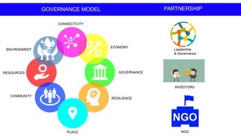 governance model and partnership
 -
 transect method


C.4 References
file:///C:/Users/TS-03/Downloads/Cardiff%202025%20Chap%2011%20(1).pdf
file:///C:/Users/TS-03/Downloads/Cardiff%202025%20Chap%2013%20(2).pdf
http://www.eg.undp.org/content/egypt/en/home/operations/projects/climate-and-disaster-resilience/project_sample1.html https://www.sciencedirect.com/science/article/pii/S1110016815002112
D. Process Reflection
- Reflect in your intercultural and interdisciplinary team on the outcomes of your study
- Which limitations were you facing?
- What have you learnt from each other?
- What would you do differently next time?
- You can also use diagrams/visuals
- 250 words text
Since i worked alone in this seminar. So i didn't get the chance to get more ideas about the site so I depend on what I learned from the online seminars, readings and searching in the internet As I saw too many useful different topics related to the coastal landscapes that this problem is a global challenge affects different areas around the world and the negative effects of it will affect the local people, environment, economy and tourism industry. The importance of understanding the problem is the first step in this project. By enhancing and protecting the ecosystem services in this area is very important because the environment support us with different kind of benefits such as provisioning services, regulating the environment and the aesthetics value of it. So it is very important to asses the Existing ecosystem services in this area. Also by focus on the investing in green infrastructure we can gain huge benefits from it and create more jobs which increase the local income and create better environment for the health of local people The design should also meets different kind of people and interests. I faced also too many limitation such as; Site visiting, getting Gis maps and data, studies about the aesthetics values in this area, and the time also is not enough for putting the concept plan and more assessment for the area.