Case Study E: Kopli liinid: Difference between revisions
Alin.pricop (talk | contribs) |
|||
| (146 intermediate revisions by 7 users not shown) | |||
| Line 15: | Line 15: | ||
| '''Country''' || style="background:Lavender"|''Estonia'' | | '''Country''' || style="background:Lavender"|''Estonia'' | ||
|- | |- | ||
| '''Topics''' || style="background:Lavender"|'' | | '''Topics''' || style="background:Lavender"|''Access to the sea for everyone; Green and blue infrastructure; Sustainable housing'' | ||
|- | |- | ||
| '''Author(s)''' || style="background:Lavender"|''Kätlin Umal, Aurore Rabier, Irma Karic, Sarah Jankowski, Bine Schneider, Martina Palmiero, Pricop Alin, Najoua Saadi | | '''Author(s)''' || style="background:Lavender"|''Kätlin Umal, Aurore Rabier, Irma Karic, Sarah Jankowski, Bine Schneider, Martina Palmiero, Pricop Alin, Najoua Saadi | ||
| Line 28: | Line 28: | ||
= Rationale = | = Rationale = | ||
On the north-eastern side of the Kopli peninsula in the north of Tallinn, lays the former village for the workers of the russo-baltic shipyard. It has with time declined and turned into a wasteland. For a time, it became a shelter for the poorest and an adventure terrain for photographs or young people that want to test their courage in the abandoned houses. However, nowadays, it seems that the influence of the Kalamaja district has came to Kopli lines, and that this former ghost-town will soon turn into a new trendy neighbourhood for families. The challenge is now to respond to the housing need while respecting the coastal ecosystem. | |||
On the north-eastern side of Kopli peninsula in the north of Tallinn, lays the former village for the workers of the russo-baltic shipyard. It has with time declined and turned into a wasteland. For a time, it became a shelter for the poorest and an adventure terrain for photographs or young people that want to test their courage in the abandoned houses. However, nowadays, it seems that the influence of the Kalamaja district has came to Kopli lines, and that this former ghost-town will soon turn into a new trendy neighbourhood for families. The challenge is now to respond to the housing need while respecting the coastal ecosystem. | |||
= Location and scope = | = Location and scope = | ||
| Line 63: | Line 62: | ||
After the end of the Second World War, the shipyard was no longer for military purposes. Little by little, the wooden houses of Kopli lines have deteriorated and the neighborhood became a ghost town. | After the end of the Second World War, the shipyard was no longer for military purposes. Little by little, the wooden houses of Kopli lines have deteriorated and the neighborhood became a ghost town. | ||
The Kopli area is mainly a wasteland nowadays. Its reputation towards the Tallinn inhabitants is quite bad because some of the remaining houses are squatted, and many misadventure stories are told about this place. However, the character of the place and the heritage it’s showing are triggering some people’s interest. | The Kopli area is mainly a wasteland nowadays. Its reputation towards the Tallinn inhabitants is quite bad because some of the remaining houses are squatted, and many misadventure stories are told about this place. However, the character of the place, and the heritage it’s showing, are triggering some people’s interest. | ||
But the tables seemed to have turned recently, when the company OÜ Fund Ehitus invested in that place. Inspired by the popularity of the Kalamaja district, they plan to build a whole new housing neighborhood, inspired by the previous planning of the worker’s village. They intend to give to the place its former function, but the character of the 'lines' might be lost in the process. | But the tables seemed to have turned recently, when the company OÜ Fund Ehitus invested in that place. Inspired by the popularity of the Kalamaja district, they plan to build a whole new housing neighborhood, inspired by the previous planning of the worker’s village. They intend to give to the place its former function, but the character of the 'lines' might be lost in the process. | ||
[[File:Chronologic landuse.PNG|400px]] | |||
''Kopli Lines: evolution of land-use: switching between natural and housing area'' | |||
''Kopli Lines | [[File:Typo LU b.jpg|400px]] | ||
''Kopli Lines main land-use in 2019 before the work construction'' | |||
[[File:P1090255.jpg|200px]] [[File:P1090254.jpg|200px]] | |||
''April 2019: The construction has started'' | |||
=== Green/blue infrastructure === | === Green/blue infrastructure === | ||
The KOPLI bay presents a generally green character and a relatively flat topography. | The KOPLI bay presents a generally green character and a relatively flat topography. | ||
| Line 113: | Line 116: | ||
=== Sacred spaces and heritage === | === Sacred spaces and heritage === | ||
The historical memory of Tallin is very interesting and complex. | The historical memory of Tallin is very interesting and complex. | ||
1. One of the places with more historical value in the Kopli district is the Estonian Maritime Academy. | 1. One of the places with more historical value in the Kopli district is the Estonian Maritime Academy. | ||
The first maritime school in Estonia was founded in Tallinn in 1715. | The first maritime school in Estonia was founded in Tallinn in 1715. | ||
| Line 124: | Line 127: | ||
3. Wooden houses are the cultural heritage elements of this area that represent one era for this place (until WWII). They have been built for the working class community where employees of Russo-Baltic Shipyard had all the essentials for their living. The architecture of these houses shows that the community lived simple and idyllic life next to its working place with the access to the beach. | 3. Wooden houses are the cultural heritage elements of this area that represent one era for this place (until WWII). They have been built for the working class community where employees of Russo-Baltic Shipyard had all the essentials for their living. The architecture of these houses shows that the community lived simple and idyllic life next to its working place with the access to the beach. | ||
4. The Rock of Kopli Park is a protected natural monument. The density and the size of the tip of the rocks are different in different parts of the park, the large boulders are close to each other. They create an unusual and very particular environment, and are important for Estonian natural history. | 4. The Rock of Kopli Park is a protected natural monument. The density and the size of the tip of the rocks are different in different parts of the park, the large boulders are close to each other. They create an unusual and very particular environment, and are important for Estonian natural history. | ||
| Line 130: | Line 132: | ||
<gallery caption=" " widths="200px" heights="150px" perrow="5"> | <gallery caption=" " widths="200px" heights="150px" perrow="5"> | ||
File:UTILE.jpg|''Map of sacred spaces and heritage with the keywords'' | |||
File: | |||
File:Sacredspaces3.jpg|''Nikolai kirik (church) and Wooden houses'' | File:Sacredspaces3.jpg|''Nikolai kirik (church) and Wooden houses'' | ||
File:Placese1 4.jpg |''Estonian Maritime Academy and Kopli Park'' | File:Placese1 4.jpg |''Estonian Maritime Academy and Kopli Park'' | ||
| Line 137: | Line 138: | ||
=== Visual appearance and landscape narrative === | === Visual appearance and landscape narrative === | ||
The name of the peninsula comes from its past land use as a place for herding. Since then the eastern coastline has changed less than the western during the change from fishing village to industrial area with factories and supporting buildings. As the past functions are ended on the area the Kopli lines have since stayed in stagnation. | The name of the peninsula comes from its past land use as a place for herding. Since then the eastern coastline has changed less than the western during the change from fishing village to industrial area with factories and supporting buildings. As the past functions are ended on the area the Kopli lines have since stayed in stagnation. | ||
| Line 158: | Line 156: | ||
[[File:System Analysis Kopli lines.PNG|600px]] | [[File:System Analysis Kopli lines.PNG|600px]] | ||
If nothing is done for this area, the following goals of the European Union Sustainable Development Plan risk not to be fulfilled: | If nothing is done for this area, the following goals of the European Union Sustainable Development Plan risk not to be fulfilled: | ||
*''Goal 10-Reduced inequalities:'' | |||
In the Kopli lines case, the driving forces are willing to give more power to a wealthier class, which goes against the pro-poor fiscal policies that the EU is trying to implement. There's also a gentrification risk. | In the Kopli lines case, the driving forces are willing to give more power to a wealthier class, which goes against the pro-poor fiscal policies that the EU is trying to implement. There's also a gentrification risk. | ||
*''Goal 13-Climate action:'' | |||
The upcoming project proposed by OÜ Fund Ehitus, is planning to re-build houses near the coast line, not taking into account the flood risk that will increase with the climate change phenomenon. It's also disturbing the biodiversity which is already poor along the Tallinn coast (excepted the Natura 2000 area) | The upcoming project proposed by OÜ Fund Ehitus, is planning to re-build houses near the coast line, not taking into account the flood risk that will increase with the climate change phenomenon. It's also disturbing the biodiversity which is already poor along the Tallinn coast (excepted the Natura 2000 area) | ||
*''Goal 14-Life below water:'' | |||
The upcoming project will also increase the population on the peninsula, which means more visits to the coast, and more risks of an increase of waste production that can end up in the sea. | The upcoming project will also increase the population on the peninsula, which means more visits to the coast, and more risks of an increase of waste production that can end up in the sea. | ||
*''Goal 15-Life on land:'' | |||
The area of Kopli lines became a wasteland with time, which is a chance to develop an interesting ecosystem and reinforce the biodiversity. If this area is built up again, the vegetation dynamic will be stopped and highly reduced. | The area of Kopli lines became a wasteland with time, which is a chance to develop an interesting ecosystem and reinforce the biodiversity. If this area is built up again, the vegetation dynamic will be stopped and highly reduced. | ||
'''Hypothesis:''' | |||
[[File:Hypothesis Kopli Lines b.jpg|600px]] | [[File:Hypothesis Kopli Lines b.jpg|600px]] | ||
'' | *'''The dynamics that drives the future changes of the place are the development of housing and of leisure activities (tourism). By following these dynamics, the coast aesthetic qualities and biodiversity risk to decrease,the population that visits the place will be less diverse, and the heritage of the place will be lost ''' | ||
''Are there any existing initiatives taking action in this landscape ?'' | |||
In 2016 a festival occured at the Kopli lines, except this and the housing programm, no actions were taken for this landscape. The existing actions are definitely moving forward to develop the city of Tallinn. However, this development may completely erase the history and heritage of the place. | In 2016 a festival occured at the Kopli lines, except this and the housing programm, no actions were taken for this landscape. The existing actions are definitely moving forward to develop the city of Tallinn. However, this development may completely erase the history and heritage of the place. | ||
== A.3 Theory reflection == | == A.3 Theory reflection == | ||
* ''National policy (NATIONAL SPATIAL PLAN ESTONIA 2030+)'' | |||
'''How can international documents be used for the local landscape ?''' | |||
* ''International Guidance Report: [https://unhabitat.org/books/guiding-principles-for-climate-city-planning-action/ Guiding Principles for City Climate Action Planning]'' | |||
This document is presenting several principles that city can adopt in order to become more resilient to climate change and help reduce the impacts of it. There are 8 general guiding principles, the city planning should be ambitious, inclusive, fair, comprehensive and integrated, relevant, actionable, evidence-based, transparent and verifiable. At the scale of the Kopli Lines neighbourhood, there are 3 principles that will particularly help developing a climate-resilient planning. Inclusiveness, that can be applied for example by involving the former population of the neighbourhood in order to avoid social conflicts. Fairness, by developing more functionnal and pro-environmental planning alternatives. Based on evidence, by asessing the risks and potentials of the actual site. | |||
* ''European policy : About Green Infrastructure: [http://ec.europa.eu/environment/nature/biodiversity/strategy/index_en.htm?fbclid=IwAR3KuO6LQt5xm-h0NR4d8ls4vxcIVptY17vEoClNfsWMUPkly4-Hd4rARso#stra Biodiversity Strategy] and [http://ec.europa.eu/environment/eia/pdf/EIA_guidance_EIA_report_final.pdf?fbclid=IwAR0-zOfzuojeARktg-gEjEYWa7FF2Q6LtUfo8qxq_MiSzkp35-CP75ajOFM Environmental Impact Assessment of Projects] " | |||
The European Commission has set a strategy for green infrastructure. This strategy aims to halt the loss of biodiversity in Europe by 2020, through disaster risk reduction and the promotion of green continuity. Thus the enlargement of the Natura 2000 network which currently covers 18% of the territory of the U.E. The Kopli Lines study area can contribute to this policy by setting up an ecological corridor. To do this, it is above all on the connection of natural or semi-natural green fragments present on the site that we must work, then think about sustainable management of this corridor from an economic, ecological and social point of view. From an architectural point of view, the adoption of green roofs could improve the Kopli ecosystem. | |||
* ''European policy: [http://ec.europa.eu/environment/iczm/prop_iczm.htm Coastal Zone Policy]'' | |||
Included as a framework for [https://ec.europa.eu/maritimeaffairs/policy/maritime_spatial_planning_en Maritime Spatial Planning] and [http://ec.europa.eu/environment/iczm/index_en.htm Integrated Coastal Management] the Coastal Zone Policy requires the EU Member States to provide a Strategic Environmental Assessment (Directive 2001/42/EC) in order to protect the natural resources and prevent the coastal risks. | |||
Our project site could reach the recommendations of the Integrated Coastal Management by promoting coastal tourism in our area. In order to reach the goals of the Maritime Spatial Planning, the site could also help the preservation, protection and improvement of the environment; improve the resilience to climate change impacts or promote a sustainable tourism. | |||
* ''National policy [https://eesti2030.files.wordpress.com/2014/02/estonia-2030.pdf (NATIONAL SPATIAL PLAN ESTONIA 2030+)]'' | |||
Estonia has a national spatial plan 2030+ dealing with the current issues in the country´s development and the measures that should be implemented by year 2030 in order to solve those issues. One of the main challenges is to assure that every settlement of Estonia becomes livable. The future development should focus on: improving the quality of everyday life concerning the residential situation, access to jobs and education in terms of public transport, improvement of regional and international transportation, energy management- production of sustainable energy, its storage and trade-, preservation and demarcation of landscapes that define Estonian identity… This plan represents the sum of general objectives that can be reinterpreted and put in the action on local level. | Estonia has a national spatial plan 2030+ dealing with the current issues in the country´s development and the measures that should be implemented by year 2030 in order to solve those issues. One of the main challenges is to assure that every settlement of Estonia becomes livable. The future development should focus on: improving the quality of everyday life concerning the residential situation, access to jobs and education in terms of public transport, improvement of regional and international transportation, energy management- production of sustainable energy, its storage and trade-, preservation and demarcation of landscapes that define Estonian identity… This plan represents the sum of general objectives that can be reinterpreted and put in the action on local level. | ||
== A.4 References == | == A.4 References == | ||
-The last days of Kopli lines: https://www. | * [[http://geoportaal.maaamet.ee/]] Estonian Geo portal | ||
* [[https://www.google.com/maps/@59.4632926,24.6674859,14.96z]] General maps | |||
* [[https://www.muurileht.ee/galerii-kopli-liinide-viimased-paevad/?i=undefined]] The last days of Kopli lines | |||
* [[http://hiddentallinn.com/kopli-lines/]] {Forgotten Tallinn Series, Ep.3}~ Kopli Lines, Abandoned Ghost Town | |||
* [[https://arileht.delfi.ee/news/uudised/fotod-surrealistlik-vaikelu-kopli-liinidel?id=77517004]] Surreal silence on Kopli routes | |||
* [[https://arileht.delfi.ee/news/uudised/fotod-ja-video-ehitusfirma-on-kopli-liinidel-toodega-algust-teinud?id=73922113]] The construction company has started work on Kopli lines | |||
* [[https://abandonedme.com/2017/04/10/kopli-liinid/]] Stalker, a blog about abandoned world; Kopli Lines | |||
* [[https://arileht.delfi.ee/news/uudised/fotod-kopli-liinid-on-hakanud-muutuma?id=85348949]] Kopli's lines have begun to change | |||
* [[https://arileht.delfi.ee/news/uudised/fotod-kas-see-kevad-jaab-mahajaetud-kopli-liinidele-viimaseks?id=70981581]] Will this spring be the last of abandoned Kopli lines? | |||
* [[https://www.delfi.ee/news/paevauudised/eesti/droonifotod-kopli-liinidel-on-lammutustood-taies-hoos-kaunis-mereaarne-ala-ootab-uuestisundi?id=78325775]] Redging works on Kopli routes are in full swing, a beautiful seaside area is waiting for rebirth | |||
* [[https://arileht.delfi.ee/news/uudised/fotod-kaua-oodatud-sundmus-kopli-liinide-esimene-uus-maja-sai-nurgakivi?id=82198117]] Long-awaited event. The first new house on Kopli's lines became a cornerstone | |||
* [[https://www.fundehitus.ee/kopliliinid/en/]] Kopli Lines: a new residential environment on the seashore | |||
* [[https://eesti2030.files.wordpress.com/2014/02/estonia-2030.pdf]] NATIONAL SPATIAL PLAN ESTONIA 2030+ | |||
* [[https://ajapaik.ee/map/?album=3245&mapType=roadmap&lat=59.458702495484026&lng=24.676735152043193&zoom=18&photoModalOpen=1&limitToAlbum=0]] Sacred spaces and heritage_ Koplipargi | |||
* [[https://ajapaik.ee/map/?album=3245&mapType=roadmap&lat=59.46165533238641&lng=24.666667648886914&zoom=18&photoModalOpen=1&limitToAlbum=0]] Sacred spaces and heritage_ Maritime Academy | |||
* [[http://ec.europa.eu/environment/nature/biodiversity/strategy/index_en.htm?fbclid=IwAR3KuO6LQt5xm-h0NR4d8ls4vxcIVptY17vEoClNfsWMUPkly4-Hd4rARso#stra]] European policy: Biodiversity strategy | |||
* [[http://ec.europa.eu/environment/eia/pdf/EIA_guidance_EIA_report_final.pdf?fbclid=IwAR0-zOfzuojeARktg-gEjEYWa7FF2Q6LtUfo8qxq_MiSzkp35-CP75ajOFM]] European policy: Environmental Impact Assessment of Projects | |||
* [[http://ec.europa.eu/environment/iczm/prop_iczm.htm]] European policy: Coastal Zone policy | |||
* [[https://ec.europa.eu/maritimeaffairs/policy/maritime_spatial_planning_en]] European policy: Maritime spatial planning | |||
* [[http://ec.europa.eu/environment/iczm/index_en.htm]] European policy: Integrated social management | |||
= Phase B: Landscape Evaluation and Assessment = | |||
== B.1 Assessment Strategy == | |||
''In our hypothesis, we described the main drivers and the potential risks they can create on the site. Based on those risks, we defined several goals that will assess the landscape through a serie of maps following these subjects.'' | |||
'''•Preserving the heritage (both architectural and cultural)''' | |||
Due to the risk of normalisation and the potential loss of heritage we identified, we decided to map ''the political changes in land use'' that have been decided within 15 years of interval, in order to see which priorities the municipality gave to what type of land use and also to map the ''actual state of the existing constructions'', in order to see which area have more potential for a housing program, and which one have more potential for developing leisure activities. Beside this, we wanted to put an accent on existing problem of gentrification that appeared in this area after WWII by placing homeless and poor people in the area that recently will be 'kicked out'due to the new plans of placing the residential neighborhood for high-income people. | |||
'''•Keep the area accessible for the public and develop welcoming infrastructure''' | |||
In our analysis, we saw that the site is very likely to develop itself through a housing program. We also saw that it was mainly a wasteland for now, not really welcoming. The risks we identified were the gentrification and a very fast touristic development. Due to these risks, we decided to map the ''social development of Kopli lines'', ''the available network of transports'', ''the actual state of the existing roads'' and to map ''the green areas'' that could help develop new access to the site. | |||
'''•Improving the green infrastructure and reducing the planned built surface ''' | |||
Due to the risk of artificialisation of the coast, we decided to map ''the green and blue infrastructure'' with more precision, by identifying the different types of vegetation. | |||
''After mapping and analysing the maps, we developed an assessment map (problems and potentials), which summarizes the key points and the goals for the area.'' | |||
== B.2 Mapping == | == B.2 Mapping == | ||
<gallery caption=" " widths="500px" heights="200px" perrow="1"> | <gallery caption=" " widths="500px" heights="200px" perrow="1"> | ||
File: | File:Comprehersive plan.jpg|''Landuse change of the Kopli peninsula'' -Tallinn is seeing Kopli growing from a mostly harbour site with industries to a single and multi family housing area surrounded by green infrastructure and mixed business areas. The biggest changes are the growth of green areas and of planned private business areas. Seeing how the green structure has changed, we can suppose that the municipality associates the green spaces with their accessibility to the public. | ||
File: | |||
File: | File:Mappa trasporti.jpg | ||
File:Mappa bus per tallin.jpg | |||
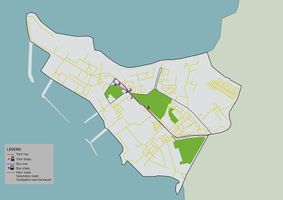
File:Mappa tram per tallin.jpg|''Map of the common transport and street'' -Kopli lines are accessible from the center of Tallinn by taking the bus or the tram. The stops are next to our site. The place is therefore accessible with common transports. It's also possible to reach it by car, by bike or by foot, but the quality of the road for the pedestrians isn't the best (walking next to the cars). Since the travel time is around 30min from the center to get to the neighbourhood, we can expect visitors that are more local than international. | |||
File:Building and road types b.png|''State of the heritage and of the place''-Because of the numerous years of abandonment, the housing heritage had suffered a lot. However, more than half of the houses can be renovated and preserved and are protected from any flooding risk. For the streets, and especially the paved ones, only a small part of it is remaining. However, it shows a good potential for improving an access to the site, especially for the pedestrians. About the flood risk, it is not that important on the site but shows the fragility of the coast towards storms, the area have then more potential for developing a green space than for developing houses. This map also shows some problems, for example with the railway that creates an unsafe physical limit for accessing the site, or the grey water evacuation that could cause some pollution problems. | |||
File:Kopli lines development.jpg|''Development of the Kopli lines'' -Kopli lines drastically changed its function in about 100 years, from idyllic neighborhood with all the essentials for living, to a ghost town neglected by the authorities and a final stop for homeless and poor people and finally to a residential area for high-income people. Political and economical changes after WWII brought the changes on social structure of Kopli lines with the final product of the exclusion of unprivileged people (gentrification) on this area. | |||
File:Kopli public-001.jpg|''Spatial ownership'' -Since the Soviet government did not allow locals to privatise their houses, the area of the Kopli lines is in possession of the government. With the decline of the district, the social cleansing and the squats, the ownership has not changed until today. That’s why the biggest part of the Kopli lines is a public space. These include meadows, public streets, a public church, the design house and the coastline. Whereas the remaining squatted buildings and ruins with the surrounding terrain assign to a more semi-public area. One bigger building in the west is privatelly owned in contrast to everything else there. | |||
File:Accessibility green and blue infrastructure.jpg| ''Typology of the green infrastructure'' -See in B.3 the analyse of the problems and potentials | |||
</gallery> | </gallery> | ||
== B.3 Problem definition and priority setting == | == B.3 Problem definition and priority setting == | ||
File: | '''Problems''' | ||
*Flooding | |||
The shore of our study area is not negatively affected by tides or the rising sea level, but it is exposed to storm surges of a high amplitude, at an unprecedented frequency in the last couple of decades, instead of one event in a century as it should occur. As a result, the moraine bluffs of the promontories are being eroded at a fast pace, and the volume of sand is decreasing, explaining the low width of the beach. | |||
Further inland, there is another depression at the end of the main road, near Susta Park, putting at risk most potential development in that area and discontinuing the accessibility. | |||
*Landscape diversity | |||
As we can observe on the map, the old functionality of the study area brings a lackluster in terms of a modern landscape diversity between housing, buisness and green areas. As a result, the accessibility is not meant for pedestrians and housing, but rather for industry. | |||
'''Potential''' | |||
There is a housing problem in Tallin, and changing the now unused industrial landscape in a housing one will reactivate the area and also help in solving the population issue. To do this, there is also the potential for funding and using the model of modern european standards in creating a sustenable and efficient landscape. There is also an upcoming touristic potential to our study area, since the area has a fascinating history and is close to the shore, bringing with it activities such as fishing, bird-watching and many more. | |||
[[File:Assessment map e.png|700px]] | |||
'''Problems and Potential of green and blue infrastructure''' | |||
Kopli now contains a patchwork of natural spaces, notably parks, residual greenspace and wetlands. These areas are considered to be real development infrastructures with several potential; ecological (rainwater retention, air purification), social (recreation, meeting, contact with nature,) functional (active mobility) and economic (attractiveness of the living environment). | |||
Despite of the presence of these natural areas, the green and blue infrastructure of Kopli remains not very accessible by public transport, highly fragmented and suffers from negative influences of urbanization. The city of Tallin is currently conducting a strategic study that aims to strengthen the links between the structuring green spaces of Kopli through a green corridor accompanied by a bicycle path layout. However, this vision ignores the potential of the unexploited residual open spaces present in Kopli. | |||
Indeed, the residual green spaces corresponding to empty areas with lawns or asphalts are spaces to maintain, because they offer an opportunity to answer the problems mentioned before. These spaces could have become gardens or park, that is to say public green spaces and recreation. Residual spaces would be areas where the idea of the metropolitan network could be reinvented. | |||
[[File:Vision of green Link.jpg|Vision of green Link.jpg |300px]] | |||
'''Priorities''' | |||
[[File:Goals and priorities a.png|300px]] | |||
== B.4 Theory reflection == | == B.4 Theory reflection == | ||
The assessment stage of our work was based on the findings from various readings that have been initially done. In that sense, we took in consideration different policies set by the EU to which our project can contribute, such as; "EU Coastal Zone Policy" to protect the natural resources and prevent the coastal risks - our project site could promote coastal tourism, protect and improve environment and improve the resilience to climate change, "National Spatial Plan Estonia 2030+" is assuring that every settlement of Estonia becomes livable with improved transportation connections - our project could contribute by the development of the residential area and the improvement of transportation network with the rest of the surrounding, "European policy : About Green Infrastructure" is dealing with halting the loss of biodiversity in Europe by 2020- our project area could contribute to this policy by setting up an ecological corridor... | |||
There were many difficulties of finding the data when mapping due to the data that are either processed on a large scale, in Estonian language or simply non-existent. | |||
== B.5 References == | == B.5 References == | ||
* | |||
*[[https://www.tallinn.ee/est/ehitus/Pohja-Tallinna-linnaosa-uldplaneering]] Landuse map of the comprehensive plan of North Tallinn subdistrict, 2017 | |||
*[[https://www.tallinn.ee/est/ehitus/g6597s45141]] Landuse map of the comprehensive plan of Tallinn, 2001 | |||
*[[http://geoportaal.maaamet.ee/]] Estonian Geo portal | |||
=Phase C – Strategy and Master Plan = | =Phase C – Strategy and Master Plan = | ||
== C.1 Goal Setting == | == C.1 Goal Setting == | ||
*'' | From our priorities and the different elements we highlighted, we developed 4 goals to guide our strategy. The main subjects that were at risk our under our priorities were the following: '''nature and biodiversity, social aspects and heritage conservation''' further on we also realised that '''public accessibility to the site''' was also a important subject to consider. Our different evaluations confirmed these were the key aspects to develop in the project. The 4 goals are then the following: | ||
* Keeping the cultural balance | |||
* Create a functional and sustainable neighbourhood: ''develop services and public place for people and build ecological friendly houses'' | |||
* Enhance nature and preserve the public spirit | |||
* Develop the access and mobility to and throughout the site: ''giving priorities to soft transportation and keeping some more intimate paths'' | |||
[[File:Goals.png|500px]] | |||
About linking our project to the EU sustainable development goals, if we refer to our first section, we were talking about the goals that were at risk, now that we started thinking about the project, we are more achieving the goal number 11: sustainable cities and communities in our project strategies. | |||
== C.2 Spatial Strategy and Transect == | == C.2 Spatial Strategy and Transect == | ||
'''Our goal:''' | |||
Sustainability in the development process. | |||
'''Our vision:''' | |||
The area of Kopli lines will turn into a multifunctional neighbourhood, developing at the same time housing and services (that will help preserve the heritage and story of the site) and a natural and recreative seaside, that might with time also invest the end of the peninsula. The link with the city and the rest of the peninsula will be reinforced in terms of green infrastructure, that will also support some soft transportation axis. | |||
<gallery caption=" " widths="500px" heights="200px" perrow="1"> | <gallery caption=" " widths="500px" heights="200px" perrow="1"> | ||
File: | File:Transect with description.jpg|'''Site transect''' ''Here our strategy and main actions are illustrated'' | ||
File: | File:Master plan finalest final.jpg|'''Masterplan''' | ||
File: | File:Schema green structures.jpg|'''Green structures''' ''Enhancing the green network and connect the green spaces between them'' | ||
File: | File:Schema active mobility.jpg|'''Active mobility''' ''Making the site accessible through various paths, with different atmospheres'' | ||
File:Schema motorized mobility.jpg| '''Motorised mobility''' ''Allowing the access to the car but developing as few roads as possible'' | |||
File:Schema construction programm.jpg| '''Construction programme''' ''Restrict the construction to where the lines are and eventually where some industries are right now '' | |||
</gallery> | </gallery> | ||
== C.3 From Theory of Change to Implementation == | == C.3 From Theory of Change to Implementation == | ||
The study area has a great potential for improvement, even though some people are content with the idea of a more wild and unkempt part of town, while others insist on changing the character of our landscape to a more civilized and populated area, reasoning that they fear the presence of homeless people and drug addicts in the area (although recognizing it got better over the years). | |||
The problems we met here are mainly in the development department: | |||
- needing new constructions besides the old wooden houses that can be reconditioned; | |||
- accessibility problems (the railway, the green areas, the beach); | |||
- lack of context, requiring a clear entrance, with the name of the area and some infrastructure to offer a neat look and a panoramic view; | |||
- bad reputation that could be ameliorated with the advent of better accessibility infrastructure and education through social events that could also help with the monotonous character of the area. | |||
In terms of who needs to act, the actors involved in our process would be stakeholders, locals, specialists on landscapes and for obtaining fundings and the city hall. | |||
The actors that need to implement the ideas are the Fund Ehitus real estate and also the municipality. The financial resources are already provided in the new incoming project, however, we can use natural corridors and the right to public access as assets. | |||
For the implementation of our goals that are meant to solve the problems that our study area is facing, we have compiled three distinct phases that were arranged by taking into consideration and balancing the restrictive factors with the potential of the area. | |||
<gallery caption=" " widths="500px" heights="200px" perrow="1"> | <gallery caption=" " widths="500px" heights="200px" perrow="1"> | ||
File: | File:Governance Kopli2.png|'''''Governance''' This model assures the accomplishment of our vision'' | ||
File: | File:Kopli phases.png|'''''Timeline''''' ''Three phases, first requiering 5 years and the second 10 years, while the third depends on the success of the first two steps'' | ||
</gallery> | </gallery> | ||
== C.4 References == | == C.4 References == | ||
* ''give a full list of the references you have used for this section'' | * ''give a full list of the references you have used for this section'' | ||
* [[http://geoportaal.maaamet.ee/]] Estonian Geo portal | |||
* [[https://www.google.com/maps/@59.4632926,24.6674859,14.96z]] General maps | |||
* [[https://arileht.delfi.ee/news/uudised/fotod-ja-video-ehitusfirma-on-kopli-liinidel-toodega-algust-teinud?id=73922113]] The construction company has started work on Kopli lines | |||
* [[https://arileht.delfi.ee/news/uudised/fotod-kopli-liinid-on-hakanud-muutuma?id=85348949]] Kopli's lines have begun to change | |||
* [[https://www.delfi.ee/news/paevauudised/eesti/droonifotod-kopli-liinidel-on-lammutustood-taies-hoos-kaunis-mereaarne-ala-ootab-uuestisundi?id=78325775]] Redging works on Kopli routes are in full swing, a beautiful seaside area is waiting for rebirth | |||
* [[https://arileht.delfi.ee/news/uudised/fotod-kaua-oodatud-sundmus-kopli-liinide-esimene-uus-maja-sai-nurgakivi?id=82198117]] Long-awaited event. The first new house on Kopli's lines became a cornerstone | |||
* [[https://www.fundehitus.ee/kopliliinid/en/]] Kopli Lines: a new residential environment on the seashore | |||
* [[https://eesti2030.files.wordpress.com/2014/02/estonia-2030.pdf]] NATIONAL SPATIAL PLAN ESTONIA 2030+ | |||
* [[https://ajapaik.ee/map/?album=3245&mapType=roadmap&lat=59.458702495484026&lng=24.676735152043193&zoom=18&photoModalOpen=1&limitToAlbum=0]] Sacred spaces and heritage_ Koplipargi | |||
* [[https://ajapaik.ee/map/?album=3245&mapType=roadmap&lat=59.46165533238641&lng=24.666667648886914&zoom=18&photoModalOpen=1&limitToAlbum=0]] Sacred spaces and heritage_ Maritime Academy | |||
* [[http://ec.europa.eu/environment/nature/biodiversity/strategy/index_en.htm?fbclid=IwAR3KuO6LQt5xm-h0NR4d8ls4vxcIVptY17vEoClNfsWMUPkly4-Hd4rARso#stra]] European policy: Biodiversity strategy | |||
* [[http://ec.europa.eu/environment/eia/pdf/EIA_guidance_EIA_report_final.pdf?fbclid=IwAR0-zOfzuojeARktg-gEjEYWa7FF2Q6LtUfo8qxq_MiSzkp35-CP75ajOFM]] European policy: Environmental Impact Assessment of Projects | |||
* [[http://ec.europa.eu/environment/iczm/prop_iczm.htm]] European policy: Coastal Zone policy | |||
* [[https://ec.europa.eu/maritimeaffairs/policy/maritime_spatial_planning_en]] European policy: Maritime spatial planning | |||
* [[http://ec.europa.eu/environment/iczm/index_en.htm]] European policy: Integrated social management | |||
= D. Process Reflection = | = D. Process Reflection = | ||
| Line 303: | Line 397: | ||
*''You can also use diagrams/visuals'' | *''You can also use diagrams/visuals'' | ||
*''250 words text'' | *''250 words text'' | ||
We encountered some limitations about the '''communication online''' (difference of schedule) but also about our difference of knowledge. The fact that '''not everyone was able to visit the site''' also created gaps in the reflexion. Finding information about the site was also difficult since some '''data were lacking''' or only in estonian. The '''language barrier''' was also an obstacle for interviews. | |||
As a team, we learned how to '''coordinate our''' efforts in order to provide the '''work in a limited time.''' | |||
Next time, we thought about '''creating another scheduled time for everyone''' to be able to discuss more and develop the project reflexion. | |||
Latest revision as of 07:46, 6 June 2019
>>>back to working groups overview
| Area | Kopli liinid | |
| Place | Tallinn | |
| Country | Estonia | |
| Topics | Access to the sea for everyone; Green and blue infrastructure; Sustainable housing | |
| Author(s) | Kätlin Umal, Aurore Rabier, Irma Karic, Sarah Jankowski, Bine Schneider, Martina Palmiero, Pricop Alin, Najoua Saadi
| |

| ||
Rationale
On the north-eastern side of the Kopli peninsula in the north of Tallinn, lays the former village for the workers of the russo-baltic shipyard. It has with time declined and turned into a wasteland. For a time, it became a shelter for the poorest and an adventure terrain for photographs or young people that want to test their courage in the abandoned houses. However, nowadays, it seems that the influence of the Kalamaja district has came to Kopli lines, and that this former ghost-town will soon turn into a new trendy neighbourhood for families. The challenge is now to respond to the housing need while respecting the coastal ecosystem.
Location and scope
You can edit this map with the map editor
A Landscape System Analysis
A.1 Landscape layers and their system context
Geomorphology, landscape units and coastal typology
The coast of Kopli Liinid is characterised by hard rock sandstone cliffs and limestone steps, soft rock coasts and wave-dominated sediment plains, which are characterised by silty, sandy, gravel, pebble and boulder beaches, about half kilometer in length.

The landscape on the coast of Kopli Lines and it's neighbours
We can find more soft rock bluffs of Quaternary glacial drift deposit at Kopli, while more eroded hard rock sandstone cliffs and limestone steps can be found at Viimsi. The main type of sediment found on our coast at Kopli is what is typically found inside most of the bays, which is sand, but because of the lower width, there are numerous rocks and pebbles scattered around, making an especially scenic site. Here we can also see the general differences between the various coastal typologies that Estonia has to offer, compared to the different landscape that Finland has in store

Coastal typologies; A-foredune ridges plain, Harilaid, Estonia (Photo H. Tõnisson), B-erosion of low sandy coast at Kopli Liind site, Estonia (Photo H. Tõnisson), C-very narrow and low sandy coast on rocky basement, kiiu Abla, North from Tallinn, Estonia (Photo T. Łabuz), D-pocket beach with ephemeral embryo forms surrounded by rocky coast, Helsinki, Finland (Photo T. Łabuz). Link:https://www.researchgate.net/figure/Low-and-scarce-sandy-coast-in-North-east-part-of-Baltic-Sea-A-foredune-ridges-plain_fig8_324177287 .
Land use
The Kopli lines history was mainly influenced by Russia and the Soviet Union. Before the XXth century, it was a natural area, where fishermen established some settlements. In 1912, Russia decided to use Tallinn as a naval base, and started to build a shipyard on the Kopli peninsula. The Kopli lines were created at that time, as the village for the workers.
After the end of the Second World War, the shipyard was no longer for military purposes. Little by little, the wooden houses of Kopli lines have deteriorated and the neighborhood became a ghost town. The Kopli area is mainly a wasteland nowadays. Its reputation towards the Tallinn inhabitants is quite bad because some of the remaining houses are squatted, and many misadventure stories are told about this place. However, the character of the place, and the heritage it’s showing, are triggering some people’s interest.
But the tables seemed to have turned recently, when the company OÜ Fund Ehitus invested in that place. Inspired by the popularity of the Kalamaja district, they plan to build a whole new housing neighborhood, inspired by the previous planning of the worker’s village. They intend to give to the place its former function, but the character of the 'lines' might be lost in the process.

Kopli Lines: evolution of land-use: switching between natural and housing area

Kopli Lines main land-use in 2019 before the work construction


April 2019: The construction has started
Green/blue infrastructure
The KOPLI bay presents a generally green character and a relatively flat topography.
Reading the green infrastructure map allows us to identify three components:
- A park located in the south of the bay named Susta-Park, with an area of 8 ha. It's characterized by its landscape diversity with wetlands, wooded areas and rocks. - Areas of lawns, planted with small scattered trees, located mainly at the seaside and to the east. - Wooded wetlands, marked on the map in (blue-green)
As for the blue infrastructure of Kopli it consists of two elements; - The running water of the sea from a shallow depth of 0 to 5 m - Stagnant water, especially large wet spots punctuated on the site.
Today, the urbanization does not stop widening to the detriment of existing green spaces and fragment the space. The map shows that green spaces are fragmented.

add a caption

add a caption
Actors and stakeholders
The landscape changes are manly driven by the investors and the city, who have both high power.
Even though, mostly affected by the landscape changes are the squatters, which are currently the only inhabitants.
-
 Power map showing the stakeholders

Sacred spaces and heritage
The historical memory of Tallin is very interesting and complex.
1. One of the places with more historical value in the Kopli district is the Estonian Maritime Academy. The first maritime school in Estonia was founded in Tallinn in 1715. Tallinn Maritime School, whose successor is the Estonian Maritime Academy of TUT, was founded as one navigation class in 1919. At the same time, in 1920 he established the School of Marine Engineers in Tallinn and in 1935 was merged with Tallinn Marine School. On August 1, 2014, the Estonian Maritime Academy joined the Tallinn University of Technology as a college member and has been renamed TUT Estonian Maritime Academy.
2. Nikolai Kirik (church) is the remaining element of the sacred places of this area. Its purpose was to serve as spiritual guidance for the local community. It has been designed by Aleksandr Vladovsky in 1935. The building resembles Russian historical wooden architecture. With its architecture, it resembles the wooden house of the working class that lived nearby. The church is an inseparable piece of pre-war cultural environment of the seaside Kopli area in Tallinn.
3. Wooden houses are the cultural heritage elements of this area that represent one era for this place (until WWII). They have been built for the working class community where employees of Russo-Baltic Shipyard had all the essentials for their living. The architecture of these houses shows that the community lived simple and idyllic life next to its working place with the access to the beach.
4. The Rock of Kopli Park is a protected natural monument. The density and the size of the tip of the rocks are different in different parts of the park, the large boulders are close to each other. They create an unusual and very particular environment, and are important for Estonian natural history.
-
 Map of sacred spaces and heritage with the keywords
 -
 Nikolai kirik (church) and Wooden houses
 -
 Estonian Maritime Academy and Kopli Park


Visual appearance and landscape narrative
The name of the peninsula comes from its past land use as a place for herding. Since then the eastern coastline has changed less than the western during the change from fishing village to industrial area with factories and supporting buildings. As the past functions are ended on the area the Kopli lines have since stayed in stagnation.
About the Kopli peninsula and its industrial past one can read in “Kopli sonata. The Russo-Baltic Shipyard.”
There are not many paintings of the area - neighboring areas with their rural/industrial settings have been inspiring more. There are but a lot of historical plans. And the site with its history and melancholy is inspiring a lot of photographers.
-
 Fisherman´s hut on the Kopli seashore by C. Fr. Chr. Buddeus (I half of 19th century)
 -
 grafiti in latin on a house waiting to be demolished
 -
 Plan of the Russo-Baltic shipyard from 1919-1920
 -
 Administrative building of the Russo-Baltic shipyard and the nearby barracks


A.2 Summary of your landscape system analysis and your development Targets

If nothing is done for this area, the following goals of the European Union Sustainable Development Plan risk not to be fulfilled:
- Goal 10-Reduced inequalities:
In the Kopli lines case, the driving forces are willing to give more power to a wealthier class, which goes against the pro-poor fiscal policies that the EU is trying to implement. There's also a gentrification risk.
- Goal 13-Climate action:
The upcoming project proposed by OÜ Fund Ehitus, is planning to re-build houses near the coast line, not taking into account the flood risk that will increase with the climate change phenomenon. It's also disturbing the biodiversity which is already poor along the Tallinn coast (excepted the Natura 2000 area)
- Goal 14-Life below water:
The upcoming project will also increase the population on the peninsula, which means more visits to the coast, and more risks of an increase of waste production that can end up in the sea.
- Goal 15-Life on land:
The area of Kopli lines became a wasteland with time, which is a chance to develop an interesting ecosystem and reinforce the biodiversity. If this area is built up again, the vegetation dynamic will be stopped and highly reduced.
Hypothesis:

- The dynamics that drives the future changes of the place are the development of housing and of leisure activities (tourism). By following these dynamics, the coast aesthetic qualities and biodiversity risk to decrease,the population that visits the place will be less diverse, and the heritage of the place will be lost
Are there any existing initiatives taking action in this landscape ?
In 2016 a festival occured at the Kopli lines, except this and the housing programm, no actions were taken for this landscape. The existing actions are definitely moving forward to develop the city of Tallinn. However, this development may completely erase the history and heritage of the place.
A.3 Theory reflection
How can international documents be used for the local landscape ?
- International Guidance Report: Guiding Principles for City Climate Action Planning
This document is presenting several principles that city can adopt in order to become more resilient to climate change and help reduce the impacts of it. There are 8 general guiding principles, the city planning should be ambitious, inclusive, fair, comprehensive and integrated, relevant, actionable, evidence-based, transparent and verifiable. At the scale of the Kopli Lines neighbourhood, there are 3 principles that will particularly help developing a climate-resilient planning. Inclusiveness, that can be applied for example by involving the former population of the neighbourhood in order to avoid social conflicts. Fairness, by developing more functionnal and pro-environmental planning alternatives. Based on evidence, by asessing the risks and potentials of the actual site.
- European policy : About Green Infrastructure: Biodiversity Strategy and Environmental Impact Assessment of Projects "
The European Commission has set a strategy for green infrastructure. This strategy aims to halt the loss of biodiversity in Europe by 2020, through disaster risk reduction and the promotion of green continuity. Thus the enlargement of the Natura 2000 network which currently covers 18% of the territory of the U.E. The Kopli Lines study area can contribute to this policy by setting up an ecological corridor. To do this, it is above all on the connection of natural or semi-natural green fragments present on the site that we must work, then think about sustainable management of this corridor from an economic, ecological and social point of view. From an architectural point of view, the adoption of green roofs could improve the Kopli ecosystem.
- European policy: Coastal Zone Policy
Included as a framework for Maritime Spatial Planning and Integrated Coastal Management the Coastal Zone Policy requires the EU Member States to provide a Strategic Environmental Assessment (Directive 2001/42/EC) in order to protect the natural resources and prevent the coastal risks. Our project site could reach the recommendations of the Integrated Coastal Management by promoting coastal tourism in our area. In order to reach the goals of the Maritime Spatial Planning, the site could also help the preservation, protection and improvement of the environment; improve the resilience to climate change impacts or promote a sustainable tourism.
- National policy (NATIONAL SPATIAL PLAN ESTONIA 2030+)
Estonia has a national spatial plan 2030+ dealing with the current issues in the country´s development and the measures that should be implemented by year 2030 in order to solve those issues. One of the main challenges is to assure that every settlement of Estonia becomes livable. The future development should focus on: improving the quality of everyday life concerning the residential situation, access to jobs and education in terms of public transport, improvement of regional and international transportation, energy management- production of sustainable energy, its storage and trade-, preservation and demarcation of landscapes that define Estonian identity… This plan represents the sum of general objectives that can be reinterpreted and put in the action on local level.
A.4 References
- [[1]] Estonian Geo portal
- [[2]] General maps
- [[3]] The last days of Kopli lines
- [[4]] {Forgotten Tallinn Series, Ep.3}~ Kopli Lines, Abandoned Ghost Town
- [[5]] Surreal silence on Kopli routes
- [[6]] The construction company has started work on Kopli lines
- [[7]] Stalker, a blog about abandoned world; Kopli Lines
- [[8]] Kopli's lines have begun to change
- [[9]] Will this spring be the last of abandoned Kopli lines?
- [[10]] Redging works on Kopli routes are in full swing, a beautiful seaside area is waiting for rebirth
- [[11]] Long-awaited event. The first new house on Kopli's lines became a cornerstone
- [[12]] Kopli Lines: a new residential environment on the seashore
- [[13]] NATIONAL SPATIAL PLAN ESTONIA 2030+
- [[14]] Sacred spaces and heritage_ Koplipargi
- [[15]] Sacred spaces and heritage_ Maritime Academy
- [[16]] European policy: Biodiversity strategy
- [[17]] European policy: Environmental Impact Assessment of Projects
- [[18]] European policy: Coastal Zone policy
- [[19]] European policy: Maritime spatial planning
- [[20]] European policy: Integrated social management
Phase B: Landscape Evaluation and Assessment
B.1 Assessment Strategy
In our hypothesis, we described the main drivers and the potential risks they can create on the site. Based on those risks, we defined several goals that will assess the landscape through a serie of maps following these subjects.
•Preserving the heritage (both architectural and cultural)
Due to the risk of normalisation and the potential loss of heritage we identified, we decided to map the political changes in land use that have been decided within 15 years of interval, in order to see which priorities the municipality gave to what type of land use and also to map the actual state of the existing constructions, in order to see which area have more potential for a housing program, and which one have more potential for developing leisure activities. Beside this, we wanted to put an accent on existing problem of gentrification that appeared in this area after WWII by placing homeless and poor people in the area that recently will be 'kicked out'due to the new plans of placing the residential neighborhood for high-income people.
•Keep the area accessible for the public and develop welcoming infrastructure
In our analysis, we saw that the site is very likely to develop itself through a housing program. We also saw that it was mainly a wasteland for now, not really welcoming. The risks we identified were the gentrification and a very fast touristic development. Due to these risks, we decided to map the social development of Kopli lines, the available network of transports, the actual state of the existing roads and to map the green areas that could help develop new access to the site.
•Improving the green infrastructure and reducing the planned built surface
Due to the risk of artificialisation of the coast, we decided to map the green and blue infrastructure with more precision, by identifying the different types of vegetation.
After mapping and analysing the maps, we developed an assessment map (problems and potentials), which summarizes the key points and the goals for the area.
B.2 Mapping
-
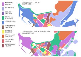 Landuse change of the Kopli peninsula -Tallinn is seeing Kopli growing from a mostly harbour site with industries to a single and multi family housing area surrounded by green infrastructure and mixed business areas. The biggest changes are the growth of green areas and of planned private business areas. Seeing how the green structure has changed, we can suppose that the municipality associates the green spaces with their accessibility to the public.
 -
-

-
 Map of the common transport and street -Kopli lines are accessible from the center of Tallinn by taking the bus or the tram. The stops are next to our site. The place is therefore accessible with common transports. It's also possible to reach it by car, by bike or by foot, but the quality of the road for the pedestrians isn't the best (walking next to the cars). Since the travel time is around 30min from the center to get to the neighbourhood, we can expect visitors that are more local than international.
 -
 State of the heritage and of the place-Because of the numerous years of abandonment, the housing heritage had suffered a lot. However, more than half of the houses can be renovated and preserved and are protected from any flooding risk. For the streets, and especially the paved ones, only a small part of it is remaining. However, it shows a good potential for improving an access to the site, especially for the pedestrians. About the flood risk, it is not that important on the site but shows the fragility of the coast towards storms, the area have then more potential for developing a green space than for developing houses. This map also shows some problems, for example with the railway that creates an unsafe physical limit for accessing the site, or the grey water evacuation that could cause some pollution problems.
 -
 Development of the Kopli lines -Kopli lines drastically changed its function in about 100 years, from idyllic neighborhood with all the essentials for living, to a ghost town neglected by the authorities and a final stop for homeless and poor people and finally to a residential area for high-income people. Political and economical changes after WWII brought the changes on social structure of Kopli lines with the final product of the exclusion of unprivileged people (gentrification) on this area.
 -
 Spatial ownership -Since the Soviet government did not allow locals to privatise their houses, the area of the Kopli lines is in possession of the government. With the decline of the district, the social cleansing and the squats, the ownership has not changed until today. That’s why the biggest part of the Kopli lines is a public space. These include meadows, public streets, a public church, the design house and the coastline. Whereas the remaining squatted buildings and ruins with the surrounding terrain assign to a more semi-public area. One bigger building in the west is privatelly owned in contrast to everything else there.
 -
 Typology of the green infrastructure -See in B.3 the analyse of the problems and potentials


B.3 Problem definition and priority setting
Problems
- Flooding
The shore of our study area is not negatively affected by tides or the rising sea level, but it is exposed to storm surges of a high amplitude, at an unprecedented frequency in the last couple of decades, instead of one event in a century as it should occur. As a result, the moraine bluffs of the promontories are being eroded at a fast pace, and the volume of sand is decreasing, explaining the low width of the beach. Further inland, there is another depression at the end of the main road, near Susta Park, putting at risk most potential development in that area and discontinuing the accessibility.
- Landscape diversity
As we can observe on the map, the old functionality of the study area brings a lackluster in terms of a modern landscape diversity between housing, buisness and green areas. As a result, the accessibility is not meant for pedestrians and housing, but rather for industry.
Potential
There is a housing problem in Tallin, and changing the now unused industrial landscape in a housing one will reactivate the area and also help in solving the population issue. To do this, there is also the potential for funding and using the model of modern european standards in creating a sustenable and efficient landscape. There is also an upcoming touristic potential to our study area, since the area has a fascinating history and is close to the shore, bringing with it activities such as fishing, bird-watching and many more.

Problems and Potential of green and blue infrastructure
Kopli now contains a patchwork of natural spaces, notably parks, residual greenspace and wetlands. These areas are considered to be real development infrastructures with several potential; ecological (rainwater retention, air purification), social (recreation, meeting, contact with nature,) functional (active mobility) and economic (attractiveness of the living environment).
Despite of the presence of these natural areas, the green and blue infrastructure of Kopli remains not very accessible by public transport, highly fragmented and suffers from negative influences of urbanization. The city of Tallin is currently conducting a strategic study that aims to strengthen the links between the structuring green spaces of Kopli through a green corridor accompanied by a bicycle path layout. However, this vision ignores the potential of the unexploited residual open spaces present in Kopli.
Indeed, the residual green spaces corresponding to empty areas with lawns or asphalts are spaces to maintain, because they offer an opportunity to answer the problems mentioned before. These spaces could have become gardens or park, that is to say public green spaces and recreation. Residual spaces would be areas where the idea of the metropolitan network could be reinvented.

Priorities

B.4 Theory reflection
The assessment stage of our work was based on the findings from various readings that have been initially done. In that sense, we took in consideration different policies set by the EU to which our project can contribute, such as; "EU Coastal Zone Policy" to protect the natural resources and prevent the coastal risks - our project site could promote coastal tourism, protect and improve environment and improve the resilience to climate change, "National Spatial Plan Estonia 2030+" is assuring that every settlement of Estonia becomes livable with improved transportation connections - our project could contribute by the development of the residential area and the improvement of transportation network with the rest of the surrounding, "European policy : About Green Infrastructure" is dealing with halting the loss of biodiversity in Europe by 2020- our project area could contribute to this policy by setting up an ecological corridor...
There were many difficulties of finding the data when mapping due to the data that are either processed on a large scale, in Estonian language or simply non-existent.
B.5 References
- [[21]] Landuse map of the comprehensive plan of North Tallinn subdistrict, 2017
- [[22]] Landuse map of the comprehensive plan of Tallinn, 2001
- [[23]] Estonian Geo portal
Phase C – Strategy and Master Plan
C.1 Goal Setting
From our priorities and the different elements we highlighted, we developed 4 goals to guide our strategy. The main subjects that were at risk our under our priorities were the following: nature and biodiversity, social aspects and heritage conservation further on we also realised that public accessibility to the site was also a important subject to consider. Our different evaluations confirmed these were the key aspects to develop in the project. The 4 goals are then the following:
- Keeping the cultural balance
- Create a functional and sustainable neighbourhood: develop services and public place for people and build ecological friendly houses
- Enhance nature and preserve the public spirit
- Develop the access and mobility to and throughout the site: giving priorities to soft transportation and keeping some more intimate paths

About linking our project to the EU sustainable development goals, if we refer to our first section, we were talking about the goals that were at risk, now that we started thinking about the project, we are more achieving the goal number 11: sustainable cities and communities in our project strategies.
C.2 Spatial Strategy and Transect
Our goal: Sustainability in the development process.
Our vision: The area of Kopli lines will turn into a multifunctional neighbourhood, developing at the same time housing and services (that will help preserve the heritage and story of the site) and a natural and recreative seaside, that might with time also invest the end of the peninsula. The link with the city and the rest of the peninsula will be reinforced in terms of green infrastructure, that will also support some soft transportation axis.
-
 Site transect Here our strategy and main actions are illustrated
 -
 Masterplan
 -
 Green structures Enhancing the green network and connect the green spaces between them
 -
 Active mobility Making the site accessible through various paths, with different atmospheres
 -
 Motorised mobility Allowing the access to the car but developing as few roads as possible
 -
 Construction programme Restrict the construction to where the lines are and eventually where some industries are right now


C.3 From Theory of Change to Implementation
The study area has a great potential for improvement, even though some people are content with the idea of a more wild and unkempt part of town, while others insist on changing the character of our landscape to a more civilized and populated area, reasoning that they fear the presence of homeless people and drug addicts in the area (although recognizing it got better over the years). The problems we met here are mainly in the development department:
- needing new constructions besides the old wooden houses that can be reconditioned;
- accessibility problems (the railway, the green areas, the beach);
- lack of context, requiring a clear entrance, with the name of the area and some infrastructure to offer a neat look and a panoramic view;
- bad reputation that could be ameliorated with the advent of better accessibility infrastructure and education through social events that could also help with the monotonous character of the area.
In terms of who needs to act, the actors involved in our process would be stakeholders, locals, specialists on landscapes and for obtaining fundings and the city hall.
The actors that need to implement the ideas are the Fund Ehitus real estate and also the municipality. The financial resources are already provided in the new incoming project, however, we can use natural corridors and the right to public access as assets.
For the implementation of our goals that are meant to solve the problems that our study area is facing, we have compiled three distinct phases that were arranged by taking into consideration and balancing the restrictive factors with the potential of the area.
-
 Governance This model assures the accomplishment of our vision
 -
 Timeline Three phases, first requiering 5 years and the second 10 years, while the third depends on the success of the first two steps


C.4 References
- give a full list of the references you have used for this section
- [[24]] Estonian Geo portal
- [[25]] General maps
- [[26]] The construction company has started work on Kopli lines
- [[27]] Kopli's lines have begun to change
- [[28]] Redging works on Kopli routes are in full swing, a beautiful seaside area is waiting for rebirth
- [[29]] Long-awaited event. The first new house on Kopli's lines became a cornerstone
- [[30]] Kopli Lines: a new residential environment on the seashore
- [[31]] NATIONAL SPATIAL PLAN ESTONIA 2030+
- [[32]] Sacred spaces and heritage_ Koplipargi
- [[33]] Sacred spaces and heritage_ Maritime Academy
- [[34]] European policy: Biodiversity strategy
- [[35]] European policy: Environmental Impact Assessment of Projects
- [[36]] European policy: Coastal Zone policy
- [[37]] European policy: Maritime spatial planning
- [[38]] European policy: Integrated social management
D. Process Reflection
- Reflect in your intercultural and interdisciplinary team on the outcomes of your study
- Which limitations were you facing?
- What have you learnt from each other?
- What would you do differently next time?
- You can also use diagrams/visuals
- 250 words text
We encountered some limitations about the communication online (difference of schedule) but also about our difference of knowledge. The fact that not everyone was able to visit the site also created gaps in the reflexion. Finding information about the site was also difficult since some data were lacking or only in estonian. The language barrier was also an obstacle for interviews.
As a team, we learned how to coordinate our efforts in order to provide the work in a limited time.
Next time, we thought about creating another scheduled time for everyone to be able to discuss more and develop the project reflexion.