COLAND Case Study 2020 - De Panne: Difference between revisions
No edit summary |
|||
| (235 intermediate revisions by 5 users not shown) | |||
| Line 15: | Line 15: | ||
| '''Country''' || style="background:Lavender"|''Belgium'' | | '''Country''' || style="background:Lavender"|''Belgium'' | ||
|- | |- | ||
| '''Topics''' || style="background:Lavender"|'' | | '''Topics''' || style="background:Lavender"|''Coastal management, Tourism, Protected areas, Biodiversity, Dune systems, Sustainability, Seasonality'' | ||
|- | |- | ||
| '''Author(s)''' || style="background:Lavender"|''Brigitta Nõmmik, Dumitru Chifa, Elina | | '''Author(s)''' || style="background:Lavender"|''Ajayi Olusegun, Amanuel Workneh, Brigitta Nõmmik, Dumitru Chifa, Elina Õunsaar'' | ||
|- | |- | ||
| colspan="3" align="center" style="background:silver"| [[File:Leopold I.jpg|400px]] | | colspan="3" align="center" style="background:silver"| [[File:Leopold I.jpg|400px]] | ||
|- | |- | ||
|- | |- | ||
| colspan="3" align="center" style="background:silver"| ''Leopold I Monument'' | | colspan="3" align="center" style="background:silver"| ''Leopold I Monument'' | ||
| Line 27: | Line 27: | ||
= Rationale = | = Rationale = | ||
A tourist target area with an extremely floating population, with high movement during the balnear season and almost a desert during the cold season. Tourism can be extremely demanding on the land and coast even more in this particular area that is surrounded by Natura 2000 protected areas. | |||
Maintaining and protecting the natural landscape while tackling the need of assuring that the appeal for the tourist continues, considering a possibility of extending the tourism season through the year avoiding desertification and keeping some constant income flow and finally approaching the car issue that is quite intense in this area. | |||
= Location and scope = | = Location and scope = | ||
''You can edit this map with the [[Special:MapEditor|map editor]]'' | ''You can edit this map with the [[Special:MapEditor|map editor]]'' | ||
{{#display_map: 51. | {{#display_map: | ||
|polygons=51.08964055159681,2.5446493749556476:51.06968933600817,2.5594122533736163:51.07227808749811,2.5800116186079913:51.073680267426965,2.5942595128951007:51.07756300550026,2.609709036820882:51.08176893742434,2.626016867631429:51.08662146068986,2.626016867631429:51.092228186950464,2.620695364945882:51.09923563898049,2.61400057124471:51.10579014366893,2.60850740718221:51.11107123354102,2.604387534135335:51.106436840156626,2.5909979467329913:51.100508450341536,2.5734884862837726:51.09468710972396,2.557867300981038~ ~ ~ ~ ~ ~#C9C9C9~0.6 | |||
}} | |||
= A Landscape System Analysis = | = A Landscape System Analysis = | ||
| Line 39: | Line 41: | ||
== A.1 Landscape layers and their system context == | == A.1 Landscape layers and their system context == | ||
=== Geomorphology, landscape units and coastal typology === | === Geomorphology, landscape units and coastal typology === | ||
'''Geomorphology:''' | |||
De Panne coastline consists of broad gently sloping sandy beaches with rows of dunes, former mudflats and salt marshes behind the dunes has been turned into polders. On the North Sea shallow continental shelf the Flemish Banks sandbanks occur. The natural beach sediments are mostly fine to medium size quartz grains. The Dunes consist of a mosaic of bare sand areas, dry, moist and wet grassland, shrub and initial dune forest. | |||
'''Evolution:''' | |||
After the melting of the North European Ice Cap the sea level started to rise (10 000 years ago) and regularly flooded flat areas sheltered by the coastal barrier. Holocene sand and clay deposited on tidal flats formed the dunes. Ongoing flooding triggered the formation of base peat where again sediments were deposited. This pattern reoccurred several times and formed the old dunes. About 3000 years ago a new dune chain was formed and old dunes disappeared. | |||
'''Drivers of Change:''' | |||
Natural interaction between the beach and the coastal dunes has been disrupted by several centuries of anthropogenic activities, the natural evolution of the coastline would be long term erosion and landward retreat. Marine processes - water level and waves erode dune toes, almost every winter sand is washed away and shoreline decreased. Regular maintenance nourishments are executed by the Coastal Division to repair this damage. | |||
<gallery caption=" " widths=" | <gallery caption=" " widths="250px" heights="150px" perrow="5"> | ||
File: | File:Coastal flood risk.jpg|''Coastal flood risk'' | ||
File: | File:depanne_coastal_section.jpg|''Coastal typology: North Sea coastal region. At the upper section is wide nourished beach and dunes are flattened for settlement, therefore providing less protection from stormwater and flooding. At the bottom section is natural narrow beach, eroded by wind, waves and tidal activity; natural shape dune up to mostly 12-15m high, behind dunes are polders that are under sea level and are protected by dunes. '' | ||
File:depanne_landscape units.jpg|''Landscape units:sea, eroded sand beach, wide sand beach, dunes: bare sand dunes, dune grasslands, dune forest; urban: mostly small private houses with garden, dense urban housing up to 4 floors and hotels up to 12 floors; agricultural land on polder (threatened by sea level rise due to climate change)'' | |||
</gallery> | </gallery> | ||
=== Land use === | === Land use === | ||
De Panne mostly consists of discontinuous urban fabric and broad-leaved forest integrated with sand dunes. The area is a part of De Westhoek Flemish Nature Reserve (345 ha), which is the only area on the Flemish coast where nearly all dune vegetation is represented in one unbroken dune landscape. The main points of attraction in the area are two artificial breaks in the dunes, which should normally keep the sea at bay, so that the sea water penetrates into the nature reserve at high tide, making the vegetation and wildlife here particularly special. | |||
Settlement in De Panne is quite dense, but gradually decreases as the city organically transitions into moors with low vegetation and sand dunes. Sand dunes and natural protection area limits the expansion of the building area, although there is also some sparse settlement near the beach and right on the border of the sand dunes. | |||
The main infrastructure consists of three main roads that connect De Panne to other districts such as Duinhoek, Oosthoek and Saint-Idesbald. From the south, the area is bordered with another highway that connects it with France. | |||
There is also a 64km coastal tram line that goes along the N34, starting in De Panne and extending all the way to Knokke-Heist. | |||
Non-irrigated arable land surrounds De Panne from the south, in the area itself there occurs no agricultural activity due to the moors and sands on the land cover. | |||
In the last 30 years, the land use hasn’t changed, only a minor increase in settlements. | |||
A great driving force in the area is tourism, as the beach area and Plopsaland De Panne theme park may be the main attraction, the De Westhoek natural reserve also plays an important role with its rich Flora, complemented by rare Fauna that might attract nature enthusiasts. | |||
Severe climate changes and the sea level rise provoque an intensification of the coastal erosion and flood occurrences along all the Belgian coastline. These changes may force mass migration towards the interior since the coastline would not be suitable for the actual human activities. | |||
<gallery caption=" " widths="200px" heights="150px" perrow="5"> | <gallery caption=" " widths="200px" heights="150px" perrow="5"> | ||
File: | File:Land cover.jpg|''Land cover'' | ||
File: | File:Road connections.jpg|''Road connections'' | ||
</gallery> | </gallery> | ||
=== Green/blue infrastructure === | === Green/blue infrastructure === | ||
The study area includes Natura 2000 birds and habitats directive sites which is a part of both the green and blue infrastructure. As the protected area is quite distributed with different peculiar landscape elements, the line between green corridor and blue infrastructure is interlacing and merging together. | |||
The major green and blue infrastructure elements are moors and heathland, sparse forest area around the centre and sand dunes. The sea is a part of blue infrastructure along with dunes and ditches in between as they contribute to the water management of De Panne. Changes could occur in the green infrastructure as the building area may expand in the future. As most of the area is protected (Natuurreservaat de Westhoek), including the sand dunes, human activity is probably not a force of change. Due to climate changes the sand dunes and surroundings will most likely be flooded in the future, which is currently managed through the dunes on the south of the city. | |||
The area is also surrounded by the mixed agricultural fields. It is a more less organized kind of farm land and animal breeding area, with almost none industrial zones. | |||
In addition to the the preserve areas and the sea, the inner city is integrated with small patches of green pocket spaces which gives relatively enough balance between the built urban setup and the natural environment. | |||
<gallery caption=" " widths="200px" heights="150px" perrow="5"> | <gallery caption=" " widths="200px" heights="150px" perrow="5"> | ||
File: | File:De Panne BlueGreen Infrastructure.png|''Green/Blue infrastructure'' | ||
File: | File:DePanne Site View.jpg|''Aerial view of De Panne'' | ||
</gallery> | </gallery> | ||
=== Actors and stakeholders === | === Actors and stakeholders === | ||
De Panne is a municipality with 10.153 citizens (NIS, 2007). It is known for its famous route called ‘Erfgoed wandeling’ (Heritage walking), Museum of Oceanic Coast and many sport activities designed for seniors. The unpredictable and dynamic nature of the De Panne coastal area requires adaptable and straightforward basic leadership that grasp a diversity of knowledge and value. Thus stakeholder involvement in the environmental decision-making has been progressively looked for and embedded into national and international policy. So the involved stakeholders concerned with the national agencies through cross-ministerial units, research institutes, coastal user-groups including the tourism industry, coastal residents, local fishers, farmers, developers, sand mining companies, CBOs (Community Based Organisation) and NGOs (Non Governamental Organisation) will be involved at all stages of the project. These stakeholders will be involved and also the beneficiaries of the project. | |||
<gallery caption=" " widths="500px" heights="200px" perrow="5"> | <gallery caption=" " widths="500px" heights="200px" perrow="5"> | ||
File: | File:PowerMap.jpg|''Power Map'' | ||
</gallery> | </gallery> | ||
=== Sacred spaces and heritage === | === Sacred spaces and heritage === | ||
'''Cultural heritage - Leopold I Monument'''<br> | |||
Leopold I memorial is designed by architect Victor Martiny and sculpted by René Cliquet. This monument made of Belgian bluestone and bronze in 1958 is located by sea opposite the Leopold I esplanade. | |||
Leopold I (16 December 1790 – 10 December 1865) was a German prince who became the first King of the Belgians. 17 July 1831, the day that he first entered to independent Belgia in De Panne is commemorated annually as Belgian National Day. He was offered the position of king because of his diplomatic connections with royal houses across Europe. He reigned 34 years during which he encouraged economic modernisation, the creation of Belgium's first railway in 1835 and subsequent industrialisation. His diplomatic action helped to avoid the spread of the Revolutions of 1848 into Belgium and even slightly expand the monarch's powers during his reign. | |||
'''Military heritage - Belgian Military Cemetery De Panne'''<br> | |||
The military graveyard is located close by the civil burial ground in De Panne. Altogether the site contains around 3370 Belgian war setbacks. De Panne is along these lines the biggest of all Belgian military burial grounds. It was started by battling units during the First World War. Afterward, graves from various smaller internment destinations in the Westhoek were moved here. | |||
'''Architectural heritage - Dumont Quarter'''<br> | |||
The Dumont Quarter is an architectural heritage created between the late 19th and early 20th century under the direction of Belgian architect Albert Dumont. His eldest son Alexis Dumont is co-designer of many buildings and also drew up the plan of the “new De Panne” in 1902-1904. | |||
This district has a unique construction plan with villas built in the style of rural cottages on top of the dunes with the respect for its existing surrounding environment. More modern villas were added later on. The Dumont Quarter has been protected since 1995. A memorial created by Alexis Dumont and Jules Lagae was erected in the district in 1926 for Albert Dumont. | |||
'''Natural heritage - The Westhoek dunes'''<br> | |||
The Westhoek dunes are part of 354 ha nature reserve right next to French border. | |||
The Westhoek dunes belong to the largest contiguous dune area of the Flemish coast and are protected as landscapes because of archeological and historical value. Area is the oldest Flemish state nature reserve, being under protection since 1935 and 1957. Dunes are characterized by the typical flora and fauna of moist hay and meadows. Also it is possible to observe the dynamic process of dune formation at the various stages of development and dune landscapes with a very different age, shape and vegetation. | |||
<gallery caption=" " widths="200px" heights="150px" perrow="5"> | <gallery caption=" " widths="200px" heights="150px" perrow="5"> | ||
File: | File:Heritage map.jpg|''Heritage location'' | ||
File: | File:Leopold I.jpg|''1 - Leopold I Monument'' | ||
File: | File:Belgian military cemetery copy.jpg |''2 - Belgian military cemetery'' | ||
File:Albert dumont monument.jpg|''3 - Albert Dumont monument'' | |||
File:The westhoek dunes.jpg|''4 - The Westhoek dunes'' | |||
</gallery> | </gallery> | ||
=== Visual appearance and landscape narrative === | === Visual appearance and landscape narrative === | ||
As De Panne is a coastal town, strong visual elements here are sea, sand (as beach and as dunes) and cottage style buildings. These elements are related with several layers of narratives providing food, shelter and amusement for local and visitors over the years. | |||
'''Narrative of fisheries''' | |||
De Panne was founded in 1783, when Austrian branch of the Habsburg Monarchy ruled the Southern Netherlands. Emperor Joseph II wanted to stimulate the inshore fisheries and agreed to erect a small fishing settlement in Adinkerke municipality. Two years after the foundation 26 households were counted in De Panne. The number of small fisheries steadily grew and flourished from the middle of the 19th century on. They were mostly herring fisheries and used specific vessels which were moored on the beach. Several small fish smokehouses were also present in the village. A wealthy landowner Pierre Bortier (1805-1879) who strongly believed that agriculture and fisheries were the crucial basis for a prosperous society, encouraged the fishermen of De Panne to take ownership of their own fishing vessels. That was one of the reasons the fisheries sector was prospered and De Panne was the second most important Belgian fishers community (after Ostend) during the second half of the 19th century. In 1903 there were 2050 inhabitants and 88 fishing vessels. But De Panne had no harbour, and although several plans were made over the years to construct a harbour, none of these projects succeeded. Due to modernisation and increase in scale the fisheries sector relocated to coastal towns with harbours after WWI and De Panne lost its importance as a fishing village. | |||
<gallery caption=" " widths="200px" heights="150px" perrow="5"> | <gallery caption=" " widths="200px" heights="150px" perrow="5"> | ||
File: | File:Edgard_Farasijn.jpg|''Edgard Farasijn (1858-1938) painting The Hotel Du Kuursaal in De Panne, before 1877'' | ||
File: | File:Carel_Nicolaas.jpg|''Carel Nicolaas Storm van's-Gravesande painting La Panne, 1877'' | ||
File: | File:fisheries_pannepot.jpg|''The fisherman’s wife came to unload the daily catch. Author G.Devent'' | ||
File:fisheries_market.jpg|''The fish auction in De Panne in 1930s. Author G.Devent'' | |||
</gallery> | |||
'''Narrative of the beach resort''' | |||
At the end of the 19th century when a beach tourism in Belgium started to become popular De Panne eventually transformed into a larger town than Adinkerke and became independent in 1911. New settlement was designed as a “garden city” to limit the impact on nature. Cottage style, art deco, art nouveau and modernist style villas give De Panne its unique appearance. The idea of healing sea baths came to the coast of Belgium from England. The seaside holiday was very popular amongst upper classes (nobility and young industrialists) for both the cure and for social amusement. After the WWI number of seaside visitors increases, as sunbathing also becomes popular. With the introduction of paid leave the elitist nature of coastal tourism gradually disappeared. New hotels, bungalows, villas and entertainment were built and the local population focused more and more on tourism and the associated secondary activities. After the Second World War, tourism expanded on a large scale, the secondary road network and habitation is expanding considerably causing dune fragmentation. | |||
<gallery caption=" " widths="200px" heights="150px" perrow="5"> | |||
File:massart-1908-foto.jpg|''Dunes of De Panne, to the left of the road that connected the then tram stop to the beach, august 1906. Author J. Massart'' | |||
File:La_Panne_Bains.jpg|''Vintage poster of De panne resort, 1912. Author anonymous.'' | |||
File:vintage_elisabeth.jpg|''French poster to advertise Le Panne resort 1920, Francis Delamare (1895-1972)'' | |||
File:Jan_Babtist.jpeg|''The mean street of De Panne, Belgium 2018. Jan Babtist.'' | |||
</gallery> | |||
'''Narrative of freedom''' | |||
The Municipality of De Panne has played a politically important role throughout history. According to the legend it was De Panne where king Leopold I stepped on to the shore of Belgium on 17 July 1831 and became its first king. | |||
During the First World War when Germany occupied Belgium, De Panne was the last free corner called "the actual capital of unoccupied Belgium". King Albert I resided there during the war and became incredibly popular because he stayed with his soldiers. This King Knight was also popular abroad as to stand against German ultimatum. During the war many refugees and allied soldiers gathered into De Panne, king family and dignities were established into the villas. All social, cultural and charitable works, also newspapers were published and printed in town, and hospitals were established to take care of wounded. In the second half of the war De Panne municipality was heavily bombarded, and the king left the town. More than half of the buildings were damaged and the population was very sparse but De Panne recovered and became a popular summer resort. | |||
Although Belgia remained neutral in the Second World War it was once again occupied by Germany. Many military buildings are still remaining from that time when German reserve troops were accommodating in De Panne. Field batteries situated on dunes of Cabour, and later on the beach of De Panne. Some bomb craters are still visible in the dunes from heavy bombing of 1944. Liberation with the help of Czechoslovakian soldiers is honored with several monuments and museums around and in De Panne. | |||
<gallery caption=" " widths="200px" heights="150px" perrow="5"> | |||
File:Royals_DePanne_foto.jpg|''Royal Residence in La Panne (1917). Author anonymous'' | |||
File:WWI_troops_foto.jpg|''During the WWI dunes were used as training ground and protection line and sandbags for the trenches were filled there. Autor anonymous'' | |||
File:Bastien_1918.png|''Dr. Depage met Queen Elisabeth in Hospital L'Océan in De Panne. (Alfred Bastien, 1918)'' | |||
File:atlanticwall_batterie_de_panne.jpg|''Adinkerke gun battery built by German troops at WWII. Author anonymous'' | |||
</gallery> | </gallery> | ||
== A.2 Summary of your landscape system analysis and your development targets == | == A.2 Summary of your landscape system analysis and your development targets == | ||
Goal 6: Clean water and sanitation - even though there is not much change in the population, the demand for proper sanitation and clean water increases with the seasonal flow of tourists. The wastewater treatment and disposal mechanisms should be given focus for better sustainable development of the site and maintaining the natural environment. | |||
Goal 7: Affordable and clean energy - the energy resource should be better suited with the efficient and sustainable development strategies. Renewable and environmentally friendly sources of energy need to be integrated in the area. Solar energy, which is already tried to be implemented in the area, and wind energy could be a good start to apply as a source of energy. | |||
Goal 8: Decent work and Economic growth - the young population in the area is noticed to migrate from the area to bigger cities and other countries. The area is basically known for its tourism activity. Though that is a good economic source, the place needs to develop enough work opportunities and economic development to sustain and further develop the city. | |||
Goal 12: Responsible consumption and production - the resource in the area, including the groundwater and the measure tourist attraction center of the coastal area, needs to be properly utilised and maintained. Over consumption of the resources will not only degrade the natural balance but also kill the whole economic and social activity of the area. | |||
Goal 13: Climate action - the area is relatively less harming to the climate, nonetheless activities that are engaged in the area need to keep improving previous impacts and counter balance the upcoming climate changes which will eventually influence the coast and the whole ecosystem of the area. | |||
Goal 14: Life below water - since the area is on the coast most activity done in the place influences the life system below the sea. The sea is part of the Natura 2000 preserve areas, which helps it to be impacted by human activities. But in addition to it the water and coastal recreation and any economic activities need to be considerate of the life cycle underwater. | |||
Goal 15: Life on Land - there are different habitat and bird preserve areas on the site. The place is integrated with complex biosystems, including forest, sand dunes, coast, sea, grassland and also the urban space within it. This mixed up life on land should be well maintained and the environment should be habitable for all the life within it. | |||
Goal 17: Partnership - the area is an ideal example where different stakeholders, the government, residents, interested investors and additional economic and social participants, are participating in the changing progress. A good partnership and collaboration between all the different groups is required to come up with a sustainable development in the area. | |||
<gallery caption=" " widths="500px" heights="200px" perrow="5"> | <gallery caption=" " widths="500px" heights="200px" perrow="5"> | ||
File: | File:Spider diagram.jpg|Spider diagram | ||
</gallery> | </gallery> | ||
In the study area, unlike most places, population growth and urbanisation are some how controlled and has less impact. Nonetheless the economic stability and the different change in the natural phenomena are major influential forces driving the change. Climate change and the change in the coastal interface of the city which is the major image of the place creates a major influence in the recent development of the area. Following those forces the activities in human and natural activities which led to changes in the area pressures the situation in the city. Pollution, sedimentation process especially in the coastal area and the habitat loss are major identified pressures in the place. The current lack of variety of job opportunity and social structure together with quality of water and waste waste production are further intrigued with upcoming pressures in the area. The resulting consequences of those driving forces results both social and natural changes. Major natural changes resulted are rise in the water level, loss of biodiversity and erosion on the coastal are. Whereas the people, especially the youth migrating to bigger cities and resulting dormant state of the place in some seasons are the sociological impacts. The actions done to counter balance these major impacts are the most sensitive parts on the current time we need to focus. In order to come up with a more sustainable development the good strategic counter acts are required. Beach nourishing, more diverse seasonal activities, preservation policies, public transport, recycling and use of renewable energy resources are considered responsive measures. Study area, unlike most places, population growth and urbanisation are some how controlled and has less impact. Nonetheless the economic stability and the different change in the natural phenomena are major influential forces driving the change. Climate change and the change in the coastal interface of the city which is the major image of the place creates a major influence in the recent development of the area. Following those forces the activities in human and natural activities which led to changes in the area pressures the situation in the city. Pollution, sedimentation process especially in the coastal area and the habitat loss are major identified pressures in the place. The current lack of variety of job opportunity and social structure together with quality of water and waste waste production are further intrigued with upcoming pressures in the area. The resulting consequences of those driving forces results both social and natural changes. Major natural changes resulted are rise in the water level, loss of biodiversity and erosion on the coastal are. Whereas the the people, especially the youth migrating to bigger cities and resulting dormant state of the place in some seasons are the sociological impacts. The actions done to counter balance these major impacts are the most sensitive parts on the current time we need to focus. In order to come up with a more sustainable development the good strategic counter acts are required. Beach nourishing, more diverse seasonal activities, preservation policies, public transport, recycling and use of renewable energy resources are considered responsive measures. | |||
<gallery caption=" " widths="500px" heights="200px" perrow="5"> | <gallery caption=" " widths="500px" heights="200px" perrow="5"> | ||
File: | File:Hypothesis illustration.jpg|Hypothesis illustration | ||
</gallery> | </gallery> | ||
'''Key words:'''''landscape fragmentation, sustainable transportation, seasonal activity and recreation and climate change.'' <br> In this city where tourism is the major economic activity we face the challenge of seasonal fluctuation on activeness of the area which raises an issue in the permanent infrastructure development. Whereas there also exists the need to maintain different landscape areas, of some under protection, and counteract the climate change. | |||
== A.3 Theory reflection == | == A.3 Theory reflection == | ||
In the '''International level''' the '''Guiding Principles for City Climate Action''' is one of the fundamental documents of the united nation published in 2015 by UN-Habitat. The guiding principle for city climate action planning is basically aimed primarily at city-level actors. They give a typical reference point to nearby authorities and local planning practitioners, just as other stakeholders in urban areas around the world. Together these eight principles are expected to be applied to significant components for the development of coastal areas (de Panne), from preparing to making a plan. (1) The Guiding Principles will be used to guide the development of de panne coastal area and (2) The Guiding Principles will also help with support from academic, private sector, and NGO endorsing partners, as well as the municipalities can be applied to help local climate action planning efforts in the communities. | |||
At '''European policy document''' the '''Integrated Coastal Management''' was adopted. The focus area could arrive at the suggestions of the Integrated Coastal Management which aims to improve the environmental management, promotes integrated coastal management methods with enhancing the protection of the coastal resources and promoting coastal tourism, reinforce local collaboration in the study area and foster sustainable coastal development: which stimulate an enduring changes are strategies towards progressively sustainable development, to support the populaces of the study area. | |||
In the '''National policy document''' the '''Natura 2000''' was used as theory of reflection at the national level which tends to focus on the network of protected region with conservation of biodiversity in terms of ensuring the long haul existence of Europe's most valuable and undermined species and habitats. Also the Natura 2000 divides conservation into types which form the cornerstone of the European Union nature Protection Policy are: (1) The Habitat directive which primary focus is on the protection of wild flora and fauna, particularly threatened or endemic species. (2) The Birds directive is aimed at protecting all wild bird habitats and wild bird species. This implies in the study area because of the natural habitat being rapidly decreasing because of the urban spread and agriculture in the area as well as the migration of species in the area. | |||
== A.4 References == | == A.4 References == | ||
* | |||
* http://ec.europa.eu/environment/iczm/index_en.htm | |||
* https://unhabitat.org/books/guiding-principles-for-climate-city-planning-action | |||
* http://ec.europa.eu/environment/nature/natura2000/index_en.htm | |||
* https://www.toerismevlaanderen.be/sites/toerismevlaanderen.be/files/assets/publication/TVL_KERNCIJFERS_2018_EN_LR_0.pdf | |||
* https://www.researchgate.net/publication/230629826_Ecological_restoration_in_Flanders | |||
* https://coastal.climatecentral.org/map/12/2.5928/51.0828/?theme=sea_level_rise&map_type=coastal_dem_comparison&elevation_model=coastal_dem&forecast_year=2050&pathway=rcp45&percentile=p50&return_level=return_level_0&slr_model=kopp_2014 | |||
* https://www.un.org/sustainabledevelopment/sustainable-development-goals/ | |||
* https://ec.europa.eu/eurostat/statistics-explained/index.php?title=Territorial_typologies_manual_-_coastal_regions#Classes_for_the_typology_and_their_conditions | |||
* http://www.vliz.be/imisdocs/publications/ocrd/263343.pdf | |||
* https://www.belgiancoast.co.uk/en/inspiration/coastal-tram | |||
* https://en.wikipedia.org/wiki/Leopold_I_of_Belgium | |||
* https://www.monarchie.be/en/royal-family/history/king-leopold-i | |||
* https://www.belgiancoast.co.uk/en/do/belgian-military-cemetery-de-panne | |||
* http://www.flandersfields.be/ | |||
* https://inventaris.onroerenderfgoed.be/erfgoedobjecten/200974 | |||
* http://tourism.depanne.be/product/1201/dumont-walking-tour | |||
* https://nl.wikipedia.org/wiki/Albert_Dumont | |||
* https://inventaris.onroerenderfgoed.be/personen/1980 | |||
* https://alexisdumont.brussels/nl/catalogus/monument-albert-dumont-albert-dumontlaan-de-panne | |||
* https://inventaris.onroerenderfgoed.be/aanduidingsobjecten/10587 | |||
* https://nl.wikipedia.org/wiki/Natuurreservaat_De_Westhoek | |||
* http://www.coastalwiki.org/wiki/Fisheries_in_De_Panne | |||
* http://www.xplorengo.com/eng/europe/Belgium/westflanders/depanne/culture.htm | |||
* https://depanne.com/en/history.php | |||
* https://inventaris.onroerenderfgoed.be/erfgoedobjecten/302416 | |||
* http://www.xplorengo.com/eng/europe/Belgium/westflanders/depanne/culture.htm | |||
* https://inventaris.onroerenderfgoed.be/erfgoedobjecten/213257 | |||
* https://inventaris.onroerenderfgoed.be/erfgoedobjecten/213256 | |||
* https://inventaris.onroerenderfgoed.be/erfgoedobjecten/213255 | |||
* https://inventaris.onroerenderfgoed.be/erfgoedobjecten/306840 | |||
* https://inventaris.onroerenderfgoed.be/erfgoedobjecten/200969 | |||
* https://spectator.sme.sk/c/20618600/czechoslovak-soldiers-remembered.html | |||
= Phase B: Landscape Evaluation and Assessment = | = Phase B: Landscape Evaluation and Assessment = | ||
== B.1 Assessment Strategy == | == B.1 Assessment Strategy == | ||
According to our hypothesis in the previous phase the main problems in the study area are an uneven flow of tourists with overflow at summer season and sudden decrease that leads to the ghost town at winter; lack of identity and massive use of cars. Our goals to assess the landscape, find the identity of the town, encourage sustainable transportation to have less pollution and control the tourist traffic and develop a strong local community with cooperation between the actors. | |||
For that, we map values to understand the nature of the different areas but also find if there are any special features to draw attention. Map of accessibility/walkability to find the opportunities to change individual car traffic with more sustainable public transport, bikes and walking. Map of the community helps us to evaluate the actors, network of public spaces and some socio-economic aspects. | |||
== B.2 Mapping == | == B.2 Mapping == | ||
<gallery caption=" " widths="500px" heights="200px" perrow="1"> | <gallery caption=" " widths="500px" heights="200px" perrow="1"> | ||
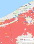
File: | File:DePanne_value_map1jpg.jpg|'''Value Map''' evaluates the aspects that have potential to draw attention and increase or decrease the value of the area. The strongest value of the area is its relatively large part of natural recreational areas like dunes and sea. The town has four areas with clearly different nature - heritage district and dune housing have potential to give the town its identity, while dense housing areas will remain neutral. Low value high rise buildings belt distracts and breaks the connection between sea and the rest of the town, therefore decreasing the value. There are not many activity points in this town. | ||
File: | |||
File: | File:Accessibility.jpg|'''Accessibility Map''' - De Panne is connected with two main roads, one connected with the high-way, this road has a tram line which starts near the train station and which follows the Belgian coast in all of its extent, the second connects with Veurne and it’s the only bus route which stops at De Panne’s main round-about. The secondary and tertiary roads spread like a spider web in the entire city, flooded with cars in every direction. This overwhelming car dominance is something hardly justified in a small-scale city like De Panne, where the whole extension of the area is barely over two kilometres. Reducing car presence would facilitate the implementation of alternative transportation (bikes, small scale public transports, etc.) and on the other hand, car-free streets create a more pleasant environment which would encourage users to walk more. | ||
File:Map 3.jpg| '''Community Map''' - Due to broad natural protected areas, the city of De Panne is narrowed down to a relatively small scale region divided between residential and 2nd housing areas. Along the coastline is a dense tourist housing strip right next to the beach, which is the main tourist hot spot in De Panne. Since the other main hot spot is the Plopsaland theme park in the south of the town, the main pathway commutes between those two sites. The city itself lacks open public spaces (i.e. parks or squares), therefore main meeting points come down to the few cultural institutions, churches and green spaces over town. Despite the heavy tourist flow, the main actors in De Panne are residents with the privately-owned property. Considering the circumstances, property developers and NGOs are also relevant in the city’s marketplace, having more and more opportunities for developing as long as there are tourists and need for housing. | |||
File:Flood Risk Map.jpg|'''2050 Flood Risk Map''' | |||
</gallery> | </gallery> | ||
== B.3 Problem definition and priority setting == | == B.3 Problem definition and priority setting == | ||
For the next phase, our first goal is to free this town of the massive amount of private cars and introduce walking, biking and alternative green energy transportation instead. As the town is only about three square km, it is perfectly accessible both to tourists and locals by train and tram. | |||
We want to develop a new identity that is based on historical houses on the dunes conception. Not encourage the development of high rise buildings, but gradually deconstruct them. And built a network of small public spaces which serves a local community all over the town. | |||
The goal is to make small gradual interventions over the years. | |||
<gallery caption=" " widths="500px" heights="200px" perrow="5"> | <gallery caption=" " widths="500px" heights="200px" perrow="5"> | ||
File: | File:SWOT.jpg|'''SWOT analyse''' | ||
</gallery> | </gallery> | ||
== B.4 Theory reflection == | == B.4 Theory reflection == | ||
To assess our contextual analysis, the techniques considered were different: after contemplating the verifiable angle and observing the area through Google maps and street map view, we decided to pick some significant techniques that had the option to understand a few perspectives of the study area and in identify the potential collaboration between the ecosystem and drivers of change in the area.<br> | |||
'''The Landscape & Visual Impact Assessment (LVIA)''' principles or theory was used to help us understand the planning decisions by distinguishing the impacts of new developments on views of the landscape itself and the ecological assets in its privilege and on how an individual sees. It implies how the negative impacts of the landscape of the study area can be reduced or maintained a strategic distance from.<br> | |||
Another method used for the theory of reflection is the '''Blue Health Environmental assessment tool (BEAT)''', which gives insight on the effect that exposure to the sea has on individuals and the tourists who come to visit and the social, physical or ecological characteristic of the environment itself in the study area. Also, these methods are liable for expanding the tourism industry and diminishing worry for users on account of the vicinity of the coastal area.<br> | |||
The '''Mainstreaming Ecosystem Services into EU''' policy which helps to understand the adoption of the ecosystem services concept in policies by integrating the use of the concept in five policies that deal with or are directly related to the use of natural resources or land in the study area in terms of Green Infrastructure Strategy (2013); Habitats Directive (1992); Biodiversity Strategy (2012); Water Framework Directive (2000); and Common Agricultural Policy (2013). This addresses the need to account for ecosystem services through biophysical mapping and connects ecosystems to human wellbeing is argued to provide a suitable, stepwise e framework for mapping ecosystem services to support EU policies more effectively. | |||
'''Limitations encountered'''<br> | |||
There were challenges of finding the information when mapping and getting an insight of the study area as a result of the data being mostly in dutch (translating was not time efficient or reliable), likewise another significant confinement has been field survey which was unrealistic for us to visit the study area and has been a significant disadvantage for this phase B, being most of our decision based on literature and assumptions. | |||
== B.5 References == | == B.5 References == | ||
* | * https://beatbluehealth.wixsite.com/site | ||
* https://biodiversity.europa.eu/maes | |||
* https://www.crcpress.com/Guidelines-for-Landscape-and-Visual-Impact-Assessment/Institute-EMA/p/book/9780415680042 | |||
* https://www.sciencedirect.com/topics/earth-and-planetary-sciences/common-agricultural-policy | |||
* https://www.google.com/maps/place/De+Panne,+Belgium/@51.0782898,2.5545699,13z/data=!3m1!4b1!4m5!3m4!1s0x47dc96975dcf9861:0x40099ab2f4d4fa0!8m2!3d51.0962794!4d2.5905629 | |||
=Phase C – Strategy and Master Plan = | =Phase C – Strategy and Master Plan = | ||
Our goal is to develop sustainable recreational resort-town with green energy policy and strong local community. For reaching this goal we defined strategic planning objectives based on the findings of previous phases. Objectives are named as: | |||
1. Develop walkable town with easy access + reasonable car use and parking. | |||
2. Encourage nature recreation | |||
3. Encourage local community | |||
4. Develop sustainable tourism all over the year. | |||
We carried out SWOT analyse for each objective to understand its strategic position. In the Phase A we set the original targets as tackle the climate change, fluctuating tourist flow, fragile social structure and environmental issues. In the Phase A.2 we listed '''the Sustainable Development Goals''' that are connected with development targets of study area. Number '''11 Sustainable cities and communities''', nr '''13 Climate action''' and nr '''15 Life on land''' are most directly connected to our development goal and objectives. | |||
<gallery caption=" " widths="500px" heights="200px" perrow="1"> | |||
File:SWOT - objectives.jpg|'''SWOT''' ''analyse of four objectives helps to find out the balance and see the obstacles that may occur during the planning process.'' | |||
</gallery> | |||
== C.2 Spatial Strategy and Transect == | == C.2 Spatial Strategy and Transect == | ||
<gallery caption=" " widths=" | The overwhelming car presence in De Panne is concerning especially in such a small area. | ||
File: | Parking cars literally on every free spot on the streets is not a welcoming approach in a resort town. The land occupied by car parking is wasted, not usable as city space. Parking in front of the buildings distracts accessibility, coming and going to parking is dangerous to other users, especially for bikers if bike lines are between car lines and parking. | ||
Once this problem was acknowledged, the approaching idea was quite clear, restrict and minimise car accessibility, provide alternative means of transport and make sure that the entire city is still functional and comfortable to its residents and tourists. | |||
File: | <gallery caption=" " widths="400px" heights="200px" perrow="5"> | ||
File:Master Plan.jpg|'''Master Plan''' '''''"Dépanne'' De Panne"''' | |||
File:Street Typology.jpg|'''Sections - Street Typology''' | |||
</gallery> | </gallery> | ||
The roads were divided into three types, primary, secondary and tertiary, where the last one was further subdivided in three. | |||
Primary roads (red) work as the main access points to the city. For the N34 was proposed only one car lane going both ways (with passing place) which would have a dissuading purpose where people will opt to leave the car in the parking space available around Plopsaland (or not bringing it at all since the train could be a viable alternative) due to the discomfort this road type can cause and take the tram to the city. The N35 is accessible by car and has the main bus route, street parking now is only allowed on one side of the street. | |||
Secondary roads (light blue) work as the main arteries in the city, these are larger streets allowing some flexibility and restricting road parking to some specific areas makes sure that there is no conflict between pedestrians and cars. | |||
Tertiary roads are subdivided into three categories: | |||
- “White” where car access is minimised to the essential (private garages and loading/unloading), no street parking is allowed, all cars should be left in the provided public parking areas or private garages, pedestrians have a total domain (some of the streets in this category have currently no pedestrian lines at all, but that “shared space” is car-dominated, parking allowed both sides of the street). | |||
- “Yellow” mainly thought for the permanent residents of De Panne allowing them more car movement since the need for it might be higher, street parking isn’t allowed (these roads would eventually transit to a white type road); | |||
- “Purple” serve the same purpose and concern as “yellow” roads but in this case, since they are larger lateral parking is allowed on one side of the road; | |||
“Green Avenue” is the major change in the city. This large open road/parking lot won’t be needed anymore due to car movement limitations, being proposed to be changed in a pedestrian road where different activity could take place. One car lane was maintained to serve a minibus round route. | |||
A circular minibus route was introduced to facilitate movement through the city. This allows to conveniently connect the different town and nature interest points and to serve more vulnerable age groups like elderly people and families with small children. | |||
All roads were thought and proposed to be bike-friendly, most of the streets provide a bike lane and in cases where that wasn’t possible sharrow lanes were introduced. With that infrastructure provided, there is a good possibility for the local municipality to introduce free bike-sharing. | |||
Despite some roads being quite strict with car movement, all accessibility was maintained, in case of any incident emergency vehicles have easy access. | |||
== C.3 From Theory of Change to Implementation == | == C.3 From Theory of Change to Implementation == | ||
In the development process we tried to prepare the city for the future we want to create step by step. The first intention is to promote walkability in urban culture. The small city could be easily accessed by pedestrians and in necessary times with possible vehicular systems. In this way, we enhance the infrastructure in the city to better pedestrian and bicycle use. This will be implemented with some trial stages at the beginning to review people’s reactions and how they would adapt to the new system. | |||
Together with the mobility, we planned on introducing a new way of experiencing and accessing the tourist destinations we have. This will also help connect the scattered green blue infrastructures and create a chance for the whole city to be explored and interacted by the tourist. | |||
All the steps will finally prepare the city to the extreme situation estimated in 2050, with the flooding. By adopting into the future the city will be ready to go along with the changes that might be brought upon in the future. | |||
<gallery caption=" " widths="500px" heights="200px" perrow="1"> | <gallery caption=" " widths="500px" heights="200px" perrow="1"> | ||
File: | |||
File: | File:Time line.jpg|'''Time line''' | ||
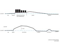
File:Transect.jpg|'''Transect''' ''of vision is showing evolving changes with 10 years steps. Starting with municipality lead changes in traffic during the first decade helps to reduce carbon emission as well as create comfortable and safe urban space for both local and visitors. During the next decade municipality cooperation with the Government is needed to start dune restauration instead of supporting low-value building strip. Any buildings with historical value (if there should be any) should be preserved during the process. With the sea level rise during the next decade resort- town faces some changes in its character and need that protecting dune buffer even more. Finally in the extreme scenario case water surrounds town of De Panne from both sides.'' | |||
</gallery> | </gallery> | ||
== C.4 References == | == C.4 References == | ||
* '' | * ''https://streetmix.net'' | ||
* ''https://www.youtube.com/watch?v=jq2yd4QgL5I'' | |||
* ''https://vimeo.com/ondemand/thehumanscale'' | |||
* ''https://gehlpeople.com/blog/public-space-and-public-life-are-more-important-than-ever/'' | |||
= D. Process Reflection = | = D. Process Reflection = | ||
Our international team consists of five people with independent-thinking skills, bringing diversity to the project. Therefore working as a team was inspiring and smooth. | |||
Communication worked better when we were able to work behind the same desk. After moving the whole process to online it was more difficult to explain our ideas to others, also to explain ideas to tutors - partly because of technical reasons as moving between the maps and sketches was more time-consuming. The lowest peak during the whole course was when the intensive programme was called off. It was really hard for us to keep up the motivation that week. Otherwise, our time management was successful and we managed to keep the process balanced. | |||
Working time in phase C was short compared to the time given in the previous phases of the project, rushing the final step is never a good idea. At the same time, phase C was the most challenging and most interesting for us. It was difficult to connect different study methods and approaches due to the access to information only available online and not being physically present in the study area. As the coastal character of the study area was new to all team members it was beneficial to get some insight from online-lectures. While some of the things we knew beforehand or learned through the course materials, having experienced these lessons make them even more important and prone to stay with us. With the end goal of this project, things we learned during this program were skills specific to collaborative efforts, allowing us to share diverse perspectives and also breaking complex tasks into parts and steps during the projects. | |||
Nevertheless, we are content with the outcome of our contribution and we are very pleased to have had such an opportunity. | |||
Latest revision as of 16:09, 16 April 2020
>>>back to working groups overview
| Area | Case Study 4: De Panne | |
| Place | De Panne | |
| Country | Belgium | |
| Topics | Coastal management, Tourism, Protected areas, Biodiversity, Dune systems, Sustainability, Seasonality | |
| Author(s) | Ajayi Olusegun, Amanuel Workneh, Brigitta Nõmmik, Dumitru Chifa, Elina Õunsaar | |

| ||
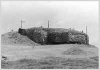
| Leopold I Monument | ||
Rationale
A tourist target area with an extremely floating population, with high movement during the balnear season and almost a desert during the cold season. Tourism can be extremely demanding on the land and coast even more in this particular area that is surrounded by Natura 2000 protected areas. Maintaining and protecting the natural landscape while tackling the need of assuring that the appeal for the tourist continues, considering a possibility of extending the tourism season through the year avoiding desertification and keeping some constant income flow and finally approaching the car issue that is quite intense in this area.
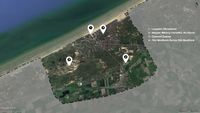
Location and scope
You can edit this map with the map editor
A Landscape System Analysis
A.1 Landscape layers and their system context
Geomorphology, landscape units and coastal typology
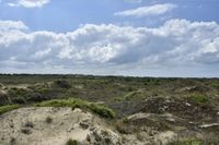
Geomorphology: De Panne coastline consists of broad gently sloping sandy beaches with rows of dunes, former mudflats and salt marshes behind the dunes has been turned into polders. On the North Sea shallow continental shelf the Flemish Banks sandbanks occur. The natural beach sediments are mostly fine to medium size quartz grains. The Dunes consist of a mosaic of bare sand areas, dry, moist and wet grassland, shrub and initial dune forest.
Evolution: After the melting of the North European Ice Cap the sea level started to rise (10 000 years ago) and regularly flooded flat areas sheltered by the coastal barrier. Holocene sand and clay deposited on tidal flats formed the dunes. Ongoing flooding triggered the formation of base peat where again sediments were deposited. This pattern reoccurred several times and formed the old dunes. About 3000 years ago a new dune chain was formed and old dunes disappeared.
Drivers of Change: Natural interaction between the beach and the coastal dunes has been disrupted by several centuries of anthropogenic activities, the natural evolution of the coastline would be long term erosion and landward retreat. Marine processes - water level and waves erode dune toes, almost every winter sand is washed away and shoreline decreased. Regular maintenance nourishments are executed by the Coastal Division to repair this damage.
-
 Coastal flood risk
 -
 Coastal typology: North Sea coastal region. At the upper section is wide nourished beach and dunes are flattened for settlement, therefore providing less protection from stormwater and flooding. At the bottom section is natural narrow beach, eroded by wind, waves and tidal activity; natural shape dune up to mostly 12-15m high, behind dunes are polders that are under sea level and are protected by dunes.
 -
 Landscape units:sea, eroded sand beach, wide sand beach, dunes: bare sand dunes, dune grasslands, dune forest; urban: mostly small private houses with garden, dense urban housing up to 4 floors and hotels up to 12 floors; agricultural land on polder (threatened by sea level rise due to climate change)


Land use
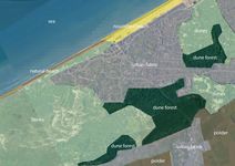
De Panne mostly consists of discontinuous urban fabric and broad-leaved forest integrated with sand dunes. The area is a part of De Westhoek Flemish Nature Reserve (345 ha), which is the only area on the Flemish coast where nearly all dune vegetation is represented in one unbroken dune landscape. The main points of attraction in the area are two artificial breaks in the dunes, which should normally keep the sea at bay, so that the sea water penetrates into the nature reserve at high tide, making the vegetation and wildlife here particularly special.
Settlement in De Panne is quite dense, but gradually decreases as the city organically transitions into moors with low vegetation and sand dunes. Sand dunes and natural protection area limits the expansion of the building area, although there is also some sparse settlement near the beach and right on the border of the sand dunes.
The main infrastructure consists of three main roads that connect De Panne to other districts such as Duinhoek, Oosthoek and Saint-Idesbald. From the south, the area is bordered with another highway that connects it with France. There is also a 64km coastal tram line that goes along the N34, starting in De Panne and extending all the way to Knokke-Heist.
Non-irrigated arable land surrounds De Panne from the south, in the area itself there occurs no agricultural activity due to the moors and sands on the land cover.
In the last 30 years, the land use hasn’t changed, only a minor increase in settlements.
A great driving force in the area is tourism, as the beach area and Plopsaland De Panne theme park may be the main attraction, the De Westhoek natural reserve also plays an important role with its rich Flora, complemented by rare Fauna that might attract nature enthusiasts.
Severe climate changes and the sea level rise provoque an intensification of the coastal erosion and flood occurrences along all the Belgian coastline. These changes may force mass migration towards the interior since the coastline would not be suitable for the actual human activities.
-
 Land cover
 -
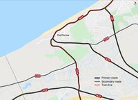 Road connections


Green/blue infrastructure
The study area includes Natura 2000 birds and habitats directive sites which is a part of both the green and blue infrastructure. As the protected area is quite distributed with different peculiar landscape elements, the line between green corridor and blue infrastructure is interlacing and merging together.
The major green and blue infrastructure elements are moors and heathland, sparse forest area around the centre and sand dunes. The sea is a part of blue infrastructure along with dunes and ditches in between as they contribute to the water management of De Panne. Changes could occur in the green infrastructure as the building area may expand in the future. As most of the area is protected (Natuurreservaat de Westhoek), including the sand dunes, human activity is probably not a force of change. Due to climate changes the sand dunes and surroundings will most likely be flooded in the future, which is currently managed through the dunes on the south of the city. The area is also surrounded by the mixed agricultural fields. It is a more less organized kind of farm land and animal breeding area, with almost none industrial zones.
In addition to the the preserve areas and the sea, the inner city is integrated with small patches of green pocket spaces which gives relatively enough balance between the built urban setup and the natural environment.
-
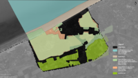 Green/Blue infrastructure
 -
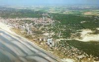 Aerial view of De Panne


Actors and stakeholders
De Panne is a municipality with 10.153 citizens (NIS, 2007). It is known for its famous route called ‘Erfgoed wandeling’ (Heritage walking), Museum of Oceanic Coast and many sport activities designed for seniors. The unpredictable and dynamic nature of the De Panne coastal area requires adaptable and straightforward basic leadership that grasp a diversity of knowledge and value. Thus stakeholder involvement in the environmental decision-making has been progressively looked for and embedded into national and international policy. So the involved stakeholders concerned with the national agencies through cross-ministerial units, research institutes, coastal user-groups including the tourism industry, coastal residents, local fishers, farmers, developers, sand mining companies, CBOs (Community Based Organisation) and NGOs (Non Governamental Organisation) will be involved at all stages of the project. These stakeholders will be involved and also the beneficiaries of the project.
-
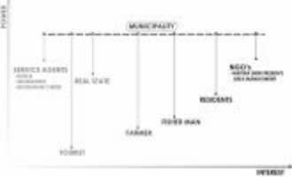 Power Map

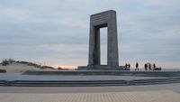
Sacred spaces and heritage
Cultural heritage - Leopold I Monument
Leopold I memorial is designed by architect Victor Martiny and sculpted by René Cliquet. This monument made of Belgian bluestone and bronze in 1958 is located by sea opposite the Leopold I esplanade.
Leopold I (16 December 1790 – 10 December 1865) was a German prince who became the first King of the Belgians. 17 July 1831, the day that he first entered to independent Belgia in De Panne is commemorated annually as Belgian National Day. He was offered the position of king because of his diplomatic connections with royal houses across Europe. He reigned 34 years during which he encouraged economic modernisation, the creation of Belgium's first railway in 1835 and subsequent industrialisation. His diplomatic action helped to avoid the spread of the Revolutions of 1848 into Belgium and even slightly expand the monarch's powers during his reign.
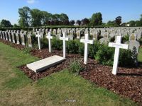
Military heritage - Belgian Military Cemetery De Panne
The military graveyard is located close by the civil burial ground in De Panne. Altogether the site contains around 3370 Belgian war setbacks. De Panne is along these lines the biggest of all Belgian military burial grounds. It was started by battling units during the First World War. Afterward, graves from various smaller internment destinations in the Westhoek were moved here.
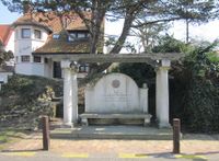
Architectural heritage - Dumont Quarter
The Dumont Quarter is an architectural heritage created between the late 19th and early 20th century under the direction of Belgian architect Albert Dumont. His eldest son Alexis Dumont is co-designer of many buildings and also drew up the plan of the “new De Panne” in 1902-1904.
This district has a unique construction plan with villas built in the style of rural cottages on top of the dunes with the respect for its existing surrounding environment. More modern villas were added later on. The Dumont Quarter has been protected since 1995. A memorial created by Alexis Dumont and Jules Lagae was erected in the district in 1926 for Albert Dumont.
Natural heritage - The Westhoek dunes
The Westhoek dunes are part of 354 ha nature reserve right next to French border. The Westhoek dunes belong to the largest contiguous dune area of the Flemish coast and are protected as landscapes because of archeological and historical value. Area is the oldest Flemish state nature reserve, being under protection since 1935 and 1957. Dunes are characterized by the typical flora and fauna of moist hay and meadows. Also it is possible to observe the dynamic process of dune formation at the various stages of development and dune landscapes with a very different age, shape and vegetation.
-
 Heritage location
 -
 1 - Leopold I Monument
 -
 2 - Belgian military cemetery
 -
 3 - Albert Dumont monument
 -
 4 - The Westhoek dunes


Visual appearance and landscape narrative
As De Panne is a coastal town, strong visual elements here are sea, sand (as beach and as dunes) and cottage style buildings. These elements are related with several layers of narratives providing food, shelter and amusement for local and visitors over the years.
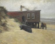
Narrative of fisheries
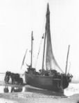
De Panne was founded in 1783, when Austrian branch of the Habsburg Monarchy ruled the Southern Netherlands. Emperor Joseph II wanted to stimulate the inshore fisheries and agreed to erect a small fishing settlement in Adinkerke municipality. Two years after the foundation 26 households were counted in De Panne. The number of small fisheries steadily grew and flourished from the middle of the 19th century on. They were mostly herring fisheries and used specific vessels which were moored on the beach. Several small fish smokehouses were also present in the village. A wealthy landowner Pierre Bortier (1805-1879) who strongly believed that agriculture and fisheries were the crucial basis for a prosperous society, encouraged the fishermen of De Panne to take ownership of their own fishing vessels. That was one of the reasons the fisheries sector was prospered and De Panne was the second most important Belgian fishers community (after Ostend) during the second half of the 19th century. In 1903 there were 2050 inhabitants and 88 fishing vessels. But De Panne had no harbour, and although several plans were made over the years to construct a harbour, none of these projects succeeded. Due to modernisation and increase in scale the fisheries sector relocated to coastal towns with harbours after WWI and De Panne lost its importance as a fishing village.
-
 Edgard Farasijn (1858-1938) painting The Hotel Du Kuursaal in De Panne, before 1877
 -
 Carel Nicolaas Storm van's-Gravesande painting La Panne, 1877
 -
 The fisherman’s wife came to unload the daily catch. Author G.Devent
 -
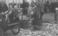 The fish auction in De Panne in 1930s. Author G.Devent


Narrative of the beach resort
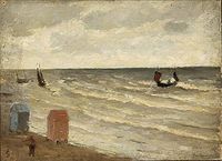
At the end of the 19th century when a beach tourism in Belgium started to become popular De Panne eventually transformed into a larger town than Adinkerke and became independent in 1911. New settlement was designed as a “garden city” to limit the impact on nature. Cottage style, art deco, art nouveau and modernist style villas give De Panne its unique appearance. The idea of healing sea baths came to the coast of Belgium from England. The seaside holiday was very popular amongst upper classes (nobility and young industrialists) for both the cure and for social amusement. After the WWI number of seaside visitors increases, as sunbathing also becomes popular. With the introduction of paid leave the elitist nature of coastal tourism gradually disappeared. New hotels, bungalows, villas and entertainment were built and the local population focused more and more on tourism and the associated secondary activities. After the Second World War, tourism expanded on a large scale, the secondary road network and habitation is expanding considerably causing dune fragmentation.
-
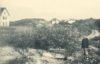 Dunes of De Panne, to the left of the road that connected the then tram stop to the beach, august 1906. Author J. Massart
 -
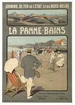 Vintage poster of De panne resort, 1912. Author anonymous.
 -
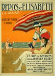 French poster to advertise Le Panne resort 1920, Francis Delamare (1895-1972)
 -
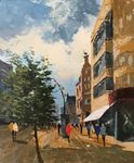 The mean street of De Panne, Belgium 2018. Jan Babtist.


Narrative of freedom
The Municipality of De Panne has played a politically important role throughout history. According to the legend it was De Panne where king Leopold I stepped on to the shore of Belgium on 17 July 1831 and became its first king. During the First World War when Germany occupied Belgium, De Panne was the last free corner called "the actual capital of unoccupied Belgium". King Albert I resided there during the war and became incredibly popular because he stayed with his soldiers. This King Knight was also popular abroad as to stand against German ultimatum. During the war many refugees and allied soldiers gathered into De Panne, king family and dignities were established into the villas. All social, cultural and charitable works, also newspapers were published and printed in town, and hospitals were established to take care of wounded. In the second half of the war De Panne municipality was heavily bombarded, and the king left the town. More than half of the buildings were damaged and the population was very sparse but De Panne recovered and became a popular summer resort. Although Belgia remained neutral in the Second World War it was once again occupied by Germany. Many military buildings are still remaining from that time when German reserve troops were accommodating in De Panne. Field batteries situated on dunes of Cabour, and later on the beach of De Panne. Some bomb craters are still visible in the dunes from heavy bombing of 1944. Liberation with the help of Czechoslovakian soldiers is honored with several monuments and museums around and in De Panne.
-
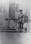 Royal Residence in La Panne (1917). Author anonymous
 -
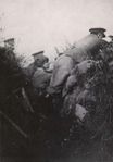 During the WWI dunes were used as training ground and protection line and sandbags for the trenches were filled there. Autor anonymous
 -
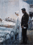 Dr. Depage met Queen Elisabeth in Hospital L'Océan in De Panne. (Alfred Bastien, 1918)
 -
 Adinkerke gun battery built by German troops at WWII. Author anonymous


A.2 Summary of your landscape system analysis and your development targets
Goal 6: Clean water and sanitation - even though there is not much change in the population, the demand for proper sanitation and clean water increases with the seasonal flow of tourists. The wastewater treatment and disposal mechanisms should be given focus for better sustainable development of the site and maintaining the natural environment.
Goal 7: Affordable and clean energy - the energy resource should be better suited with the efficient and sustainable development strategies. Renewable and environmentally friendly sources of energy need to be integrated in the area. Solar energy, which is already tried to be implemented in the area, and wind energy could be a good start to apply as a source of energy.
Goal 8: Decent work and Economic growth - the young population in the area is noticed to migrate from the area to bigger cities and other countries. The area is basically known for its tourism activity. Though that is a good economic source, the place needs to develop enough work opportunities and economic development to sustain and further develop the city.
Goal 12: Responsible consumption and production - the resource in the area, including the groundwater and the measure tourist attraction center of the coastal area, needs to be properly utilised and maintained. Over consumption of the resources will not only degrade the natural balance but also kill the whole economic and social activity of the area.
Goal 13: Climate action - the area is relatively less harming to the climate, nonetheless activities that are engaged in the area need to keep improving previous impacts and counter balance the upcoming climate changes which will eventually influence the coast and the whole ecosystem of the area.
Goal 14: Life below water - since the area is on the coast most activity done in the place influences the life system below the sea. The sea is part of the Natura 2000 preserve areas, which helps it to be impacted by human activities. But in addition to it the water and coastal recreation and any economic activities need to be considerate of the life cycle underwater.
Goal 15: Life on Land - there are different habitat and bird preserve areas on the site. The place is integrated with complex biosystems, including forest, sand dunes, coast, sea, grassland and also the urban space within it. This mixed up life on land should be well maintained and the environment should be habitable for all the life within it.
Goal 17: Partnership - the area is an ideal example where different stakeholders, the government, residents, interested investors and additional economic and social participants, are participating in the changing progress. A good partnership and collaboration between all the different groups is required to come up with a sustainable development in the area.
-
 Spider diagram

In the study area, unlike most places, population growth and urbanisation are some how controlled and has less impact. Nonetheless the economic stability and the different change in the natural phenomena are major influential forces driving the change. Climate change and the change in the coastal interface of the city which is the major image of the place creates a major influence in the recent development of the area. Following those forces the activities in human and natural activities which led to changes in the area pressures the situation in the city. Pollution, sedimentation process especially in the coastal area and the habitat loss are major identified pressures in the place. The current lack of variety of job opportunity and social structure together with quality of water and waste waste production are further intrigued with upcoming pressures in the area. The resulting consequences of those driving forces results both social and natural changes. Major natural changes resulted are rise in the water level, loss of biodiversity and erosion on the coastal are. Whereas the people, especially the youth migrating to bigger cities and resulting dormant state of the place in some seasons are the sociological impacts. The actions done to counter balance these major impacts are the most sensitive parts on the current time we need to focus. In order to come up with a more sustainable development the good strategic counter acts are required. Beach nourishing, more diverse seasonal activities, preservation policies, public transport, recycling and use of renewable energy resources are considered responsive measures. Study area, unlike most places, population growth and urbanisation are some how controlled and has less impact. Nonetheless the economic stability and the different change in the natural phenomena are major influential forces driving the change. Climate change and the change in the coastal interface of the city which is the major image of the place creates a major influence in the recent development of the area. Following those forces the activities in human and natural activities which led to changes in the area pressures the situation in the city. Pollution, sedimentation process especially in the coastal area and the habitat loss are major identified pressures in the place. The current lack of variety of job opportunity and social structure together with quality of water and waste waste production are further intrigued with upcoming pressures in the area. The resulting consequences of those driving forces results both social and natural changes. Major natural changes resulted are rise in the water level, loss of biodiversity and erosion on the coastal are. Whereas the the people, especially the youth migrating to bigger cities and resulting dormant state of the place in some seasons are the sociological impacts. The actions done to counter balance these major impacts are the most sensitive parts on the current time we need to focus. In order to come up with a more sustainable development the good strategic counter acts are required. Beach nourishing, more diverse seasonal activities, preservation policies, public transport, recycling and use of renewable energy resources are considered responsive measures.
-
 Hypothesis illustration

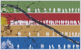
Key words:landscape fragmentation, sustainable transportation, seasonal activity and recreation and climate change.
In this city where tourism is the major economic activity we face the challenge of seasonal fluctuation on activeness of the area which raises an issue in the permanent infrastructure development. Whereas there also exists the need to maintain different landscape areas, of some under protection, and counteract the climate change.
A.3 Theory reflection
In the International level the Guiding Principles for City Climate Action is one of the fundamental documents of the united nation published in 2015 by UN-Habitat. The guiding principle for city climate action planning is basically aimed primarily at city-level actors. They give a typical reference point to nearby authorities and local planning practitioners, just as other stakeholders in urban areas around the world. Together these eight principles are expected to be applied to significant components for the development of coastal areas (de Panne), from preparing to making a plan. (1) The Guiding Principles will be used to guide the development of de panne coastal area and (2) The Guiding Principles will also help with support from academic, private sector, and NGO endorsing partners, as well as the municipalities can be applied to help local climate action planning efforts in the communities.
At European policy document the Integrated Coastal Management was adopted. The focus area could arrive at the suggestions of the Integrated Coastal Management which aims to improve the environmental management, promotes integrated coastal management methods with enhancing the protection of the coastal resources and promoting coastal tourism, reinforce local collaboration in the study area and foster sustainable coastal development: which stimulate an enduring changes are strategies towards progressively sustainable development, to support the populaces of the study area.
In the National policy document the Natura 2000 was used as theory of reflection at the national level which tends to focus on the network of protected region with conservation of biodiversity in terms of ensuring the long haul existence of Europe's most valuable and undermined species and habitats. Also the Natura 2000 divides conservation into types which form the cornerstone of the European Union nature Protection Policy are: (1) The Habitat directive which primary focus is on the protection of wild flora and fauna, particularly threatened or endemic species. (2) The Birds directive is aimed at protecting all wild bird habitats and wild bird species. This implies in the study area because of the natural habitat being rapidly decreasing because of the urban spread and agriculture in the area as well as the migration of species in the area.
A.4 References
- http://ec.europa.eu/environment/iczm/index_en.htm
- https://unhabitat.org/books/guiding-principles-for-climate-city-planning-action
- http://ec.europa.eu/environment/nature/natura2000/index_en.htm
- https://www.toerismevlaanderen.be/sites/toerismevlaanderen.be/files/assets/publication/TVL_KERNCIJFERS_2018_EN_LR_0.pdf
- https://www.researchgate.net/publication/230629826_Ecological_restoration_in_Flanders
- https://coastal.climatecentral.org/map/12/2.5928/51.0828/?theme=sea_level_rise&map_type=coastal_dem_comparison&elevation_model=coastal_dem&forecast_year=2050&pathway=rcp45&percentile=p50&return_level=return_level_0&slr_model=kopp_2014
- https://www.un.org/sustainabledevelopment/sustainable-development-goals/
- https://ec.europa.eu/eurostat/statistics-explained/index.php?title=Territorial_typologies_manual_-_coastal_regions#Classes_for_the_typology_and_their_conditions
- http://www.vliz.be/imisdocs/publications/ocrd/263343.pdf
- https://www.belgiancoast.co.uk/en/inspiration/coastal-tram
- https://en.wikipedia.org/wiki/Leopold_I_of_Belgium
- https://www.monarchie.be/en/royal-family/history/king-leopold-i
- https://www.belgiancoast.co.uk/en/do/belgian-military-cemetery-de-panne
- http://www.flandersfields.be/
- https://inventaris.onroerenderfgoed.be/erfgoedobjecten/200974
- http://tourism.depanne.be/product/1201/dumont-walking-tour
- https://nl.wikipedia.org/wiki/Albert_Dumont
- https://inventaris.onroerenderfgoed.be/personen/1980
- https://alexisdumont.brussels/nl/catalogus/monument-albert-dumont-albert-dumontlaan-de-panne
- https://inventaris.onroerenderfgoed.be/aanduidingsobjecten/10587
- https://nl.wikipedia.org/wiki/Natuurreservaat_De_Westhoek
- http://www.coastalwiki.org/wiki/Fisheries_in_De_Panne
- http://www.xplorengo.com/eng/europe/Belgium/westflanders/depanne/culture.htm
- https://depanne.com/en/history.php
- https://inventaris.onroerenderfgoed.be/erfgoedobjecten/302416
- http://www.xplorengo.com/eng/europe/Belgium/westflanders/depanne/culture.htm
- https://inventaris.onroerenderfgoed.be/erfgoedobjecten/213257
- https://inventaris.onroerenderfgoed.be/erfgoedobjecten/213256
- https://inventaris.onroerenderfgoed.be/erfgoedobjecten/213255
- https://inventaris.onroerenderfgoed.be/erfgoedobjecten/306840
- https://inventaris.onroerenderfgoed.be/erfgoedobjecten/200969
- https://spectator.sme.sk/c/20618600/czechoslovak-soldiers-remembered.html
Phase B: Landscape Evaluation and Assessment
B.1 Assessment Strategy
According to our hypothesis in the previous phase the main problems in the study area are an uneven flow of tourists with overflow at summer season and sudden decrease that leads to the ghost town at winter; lack of identity and massive use of cars. Our goals to assess the landscape, find the identity of the town, encourage sustainable transportation to have less pollution and control the tourist traffic and develop a strong local community with cooperation between the actors. For that, we map values to understand the nature of the different areas but also find if there are any special features to draw attention. Map of accessibility/walkability to find the opportunities to change individual car traffic with more sustainable public transport, bikes and walking. Map of the community helps us to evaluate the actors, network of public spaces and some socio-economic aspects.
B.2 Mapping
-
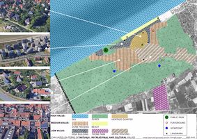 Value Map evaluates the aspects that have potential to draw attention and increase or decrease the value of the area. The strongest value of the area is its relatively large part of natural recreational areas like dunes and sea. The town has four areas with clearly different nature - heritage district and dune housing have potential to give the town its identity, while dense housing areas will remain neutral. Low value high rise buildings belt distracts and breaks the connection between sea and the rest of the town, therefore decreasing the value. There are not many activity points in this town.
 -
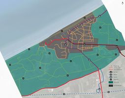 Accessibility Map - De Panne is connected with two main roads, one connected with the high-way, this road has a tram line which starts near the train station and which follows the Belgian coast in all of its extent, the second connects with Veurne and it’s the only bus route which stops at De Panne’s main round-about. The secondary and tertiary roads spread like a spider web in the entire city, flooded with cars in every direction. This overwhelming car dominance is something hardly justified in a small-scale city like De Panne, where the whole extension of the area is barely over two kilometres. Reducing car presence would facilitate the implementation of alternative transportation (bikes, small scale public transports, etc.) and on the other hand, car-free streets create a more pleasant environment which would encourage users to walk more.
 -
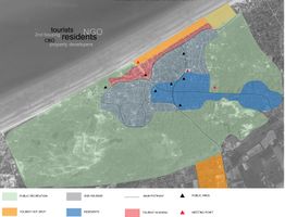 Community Map - Due to broad natural protected areas, the city of De Panne is narrowed down to a relatively small scale region divided between residential and 2nd housing areas. Along the coastline is a dense tourist housing strip right next to the beach, which is the main tourist hot spot in De Panne. Since the other main hot spot is the Plopsaland theme park in the south of the town, the main pathway commutes between those two sites. The city itself lacks open public spaces (i.e. parks or squares), therefore main meeting points come down to the few cultural institutions, churches and green spaces over town. Despite the heavy tourist flow, the main actors in De Panne are residents with the privately-owned property. Considering the circumstances, property developers and NGOs are also relevant in the city’s marketplace, having more and more opportunities for developing as long as there are tourists and need for housing.
 -
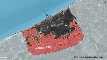 2050 Flood Risk Map


B.3 Problem definition and priority setting
For the next phase, our first goal is to free this town of the massive amount of private cars and introduce walking, biking and alternative green energy transportation instead. As the town is only about three square km, it is perfectly accessible both to tourists and locals by train and tram.
We want to develop a new identity that is based on historical houses on the dunes conception. Not encourage the development of high rise buildings, but gradually deconstruct them. And built a network of small public spaces which serves a local community all over the town.
The goal is to make small gradual interventions over the years.
-
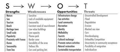 SWOT analyse

B.4 Theory reflection
To assess our contextual analysis, the techniques considered were different: after contemplating the verifiable angle and observing the area through Google maps and street map view, we decided to pick some significant techniques that had the option to understand a few perspectives of the study area and in identify the potential collaboration between the ecosystem and drivers of change in the area.
The Landscape & Visual Impact Assessment (LVIA) principles or theory was used to help us understand the planning decisions by distinguishing the impacts of new developments on views of the landscape itself and the ecological assets in its privilege and on how an individual sees. It implies how the negative impacts of the landscape of the study area can be reduced or maintained a strategic distance from.
Another method used for the theory of reflection is the Blue Health Environmental assessment tool (BEAT), which gives insight on the effect that exposure to the sea has on individuals and the tourists who come to visit and the social, physical or ecological characteristic of the environment itself in the study area. Also, these methods are liable for expanding the tourism industry and diminishing worry for users on account of the vicinity of the coastal area.
The Mainstreaming Ecosystem Services into EU policy which helps to understand the adoption of the ecosystem services concept in policies by integrating the use of the concept in five policies that deal with or are directly related to the use of natural resources or land in the study area in terms of Green Infrastructure Strategy (2013); Habitats Directive (1992); Biodiversity Strategy (2012); Water Framework Directive (2000); and Common Agricultural Policy (2013). This addresses the need to account for ecosystem services through biophysical mapping and connects ecosystems to human wellbeing is argued to provide a suitable, stepwise e framework for mapping ecosystem services to support EU policies more effectively.
Limitations encountered
There were challenges of finding the information when mapping and getting an insight of the study area as a result of the data being mostly in dutch (translating was not time efficient or reliable), likewise another significant confinement has been field survey which was unrealistic for us to visit the study area and has been a significant disadvantage for this phase B, being most of our decision based on literature and assumptions.
B.5 References
- https://beatbluehealth.wixsite.com/site
- https://biodiversity.europa.eu/maes
- https://www.crcpress.com/Guidelines-for-Landscape-and-Visual-Impact-Assessment/Institute-EMA/p/book/9780415680042
- https://www.sciencedirect.com/topics/earth-and-planetary-sciences/common-agricultural-policy
- https://www.google.com/maps/place/De+Panne,+Belgium/@51.0782898,2.5545699,13z/data=!3m1!4b1!4m5!3m4!1s0x47dc96975dcf9861:0x40099ab2f4d4fa0!8m2!3d51.0962794!4d2.5905629
Phase C – Strategy and Master Plan
Our goal is to develop sustainable recreational resort-town with green energy policy and strong local community. For reaching this goal we defined strategic planning objectives based on the findings of previous phases. Objectives are named as:
1. Develop walkable town with easy access + reasonable car use and parking.
2. Encourage nature recreation
3. Encourage local community
4. Develop sustainable tourism all over the year.
We carried out SWOT analyse for each objective to understand its strategic position. In the Phase A we set the original targets as tackle the climate change, fluctuating tourist flow, fragile social structure and environmental issues. In the Phase A.2 we listed the Sustainable Development Goals that are connected with development targets of study area. Number 11 Sustainable cities and communities, nr 13 Climate action and nr 15 Life on land are most directly connected to our development goal and objectives.
-
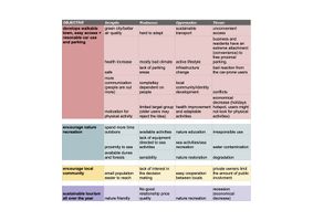 SWOT analyse of four objectives helps to find out the balance and see the obstacles that may occur during the planning process.

C.2 Spatial Strategy and Transect
The overwhelming car presence in De Panne is concerning especially in such a small area. Parking cars literally on every free spot on the streets is not a welcoming approach in a resort town. The land occupied by car parking is wasted, not usable as city space. Parking in front of the buildings distracts accessibility, coming and going to parking is dangerous to other users, especially for bikers if bike lines are between car lines and parking. Once this problem was acknowledged, the approaching idea was quite clear, restrict and minimise car accessibility, provide alternative means of transport and make sure that the entire city is still functional and comfortable to its residents and tourists.
-
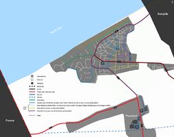 Master Plan "Dépanne De Panne"
 -
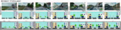 Sections - Street Typology


The roads were divided into three types, primary, secondary and tertiary, where the last one was further subdivided in three.
Primary roads (red) work as the main access points to the city. For the N34 was proposed only one car lane going both ways (with passing place) which would have a dissuading purpose where people will opt to leave the car in the parking space available around Plopsaland (or not bringing it at all since the train could be a viable alternative) due to the discomfort this road type can cause and take the tram to the city. The N35 is accessible by car and has the main bus route, street parking now is only allowed on one side of the street.
Secondary roads (light blue) work as the main arteries in the city, these are larger streets allowing some flexibility and restricting road parking to some specific areas makes sure that there is no conflict between pedestrians and cars.
Tertiary roads are subdivided into three categories:
- “White” where car access is minimised to the essential (private garages and loading/unloading), no street parking is allowed, all cars should be left in the provided public parking areas or private garages, pedestrians have a total domain (some of the streets in this category have currently no pedestrian lines at all, but that “shared space” is car-dominated, parking allowed both sides of the street).
- “Yellow” mainly thought for the permanent residents of De Panne allowing them more car movement since the need for it might be higher, street parking isn’t allowed (these roads would eventually transit to a white type road);
- “Purple” serve the same purpose and concern as “yellow” roads but in this case, since they are larger lateral parking is allowed on one side of the road;
“Green Avenue” is the major change in the city. This large open road/parking lot won’t be needed anymore due to car movement limitations, being proposed to be changed in a pedestrian road where different activity could take place. One car lane was maintained to serve a minibus round route.
A circular minibus route was introduced to facilitate movement through the city. This allows to conveniently connect the different town and nature interest points and to serve more vulnerable age groups like elderly people and families with small children.
All roads were thought and proposed to be bike-friendly, most of the streets provide a bike lane and in cases where that wasn’t possible sharrow lanes were introduced. With that infrastructure provided, there is a good possibility for the local municipality to introduce free bike-sharing.
Despite some roads being quite strict with car movement, all accessibility was maintained, in case of any incident emergency vehicles have easy access.
C.3 From Theory of Change to Implementation
In the development process we tried to prepare the city for the future we want to create step by step. The first intention is to promote walkability in urban culture. The small city could be easily accessed by pedestrians and in necessary times with possible vehicular systems. In this way, we enhance the infrastructure in the city to better pedestrian and bicycle use. This will be implemented with some trial stages at the beginning to review people’s reactions and how they would adapt to the new system. Together with the mobility, we planned on introducing a new way of experiencing and accessing the tourist destinations we have. This will also help connect the scattered green blue infrastructures and create a chance for the whole city to be explored and interacted by the tourist. All the steps will finally prepare the city to the extreme situation estimated in 2050, with the flooding. By adopting into the future the city will be ready to go along with the changes that might be brought upon in the future.
-
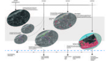 Time line
 -
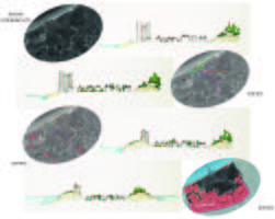 Transect of vision is showing evolving changes with 10 years steps. Starting with municipality lead changes in traffic during the first decade helps to reduce carbon emission as well as create comfortable and safe urban space for both local and visitors. During the next decade municipality cooperation with the Government is needed to start dune restauration instead of supporting low-value building strip. Any buildings with historical value (if there should be any) should be preserved during the process. With the sea level rise during the next decade resort- town faces some changes in its character and need that protecting dune buffer even more. Finally in the extreme scenario case water surrounds town of De Panne from both sides.


C.4 References
- https://streetmix.net
- https://www.youtube.com/watch?v=jq2yd4QgL5I
- https://vimeo.com/ondemand/thehumanscale
- https://gehlpeople.com/blog/public-space-and-public-life-are-more-important-than-ever/
D. Process Reflection
Our international team consists of five people with independent-thinking skills, bringing diversity to the project. Therefore working as a team was inspiring and smooth.
Communication worked better when we were able to work behind the same desk. After moving the whole process to online it was more difficult to explain our ideas to others, also to explain ideas to tutors - partly because of technical reasons as moving between the maps and sketches was more time-consuming. The lowest peak during the whole course was when the intensive programme was called off. It was really hard for us to keep up the motivation that week. Otherwise, our time management was successful and we managed to keep the process balanced.
Working time in phase C was short compared to the time given in the previous phases of the project, rushing the final step is never a good idea. At the same time, phase C was the most challenging and most interesting for us. It was difficult to connect different study methods and approaches due to the access to information only available online and not being physically present in the study area. As the coastal character of the study area was new to all team members it was beneficial to get some insight from online-lectures. While some of the things we knew beforehand or learned through the course materials, having experienced these lessons make them even more important and prone to stay with us. With the end goal of this project, things we learned during this program were skills specific to collaborative efforts, allowing us to share diverse perspectives and also breaking complex tasks into parts and steps during the projects.
Nevertheless, we are content with the outcome of our contribution and we are very pleased to have had such an opportunity.