COLAND Case Study 2020 - Dunkerque (West): Difference between revisions
| (63 intermediate revisions by 7 users not shown) | |||
| Line 10: | Line 10: | ||
{| align="right" width="400pt" style="background:Gainsboro; color:black" | {| align="right" width="400pt" style="background:Gainsboro; color:black" | ||
|- | |- | ||
| '''Area''' ||style="background:Lavender"| '' | | '''Area''' ||style="background:Lavender"| ''Dunkerque West'' | ||
|- | |- | ||
| '''Place''' || style="background:Lavender"|'' | | '''Place''' || style="background:Lavender"|''Dunkerque, department of Nord and the Nord-Pas-de-Calais region'' | ||
|- | |- | ||
| '''Country''' || style="background:Lavender"|'' | | '''Country''' || style="background:Lavender"|''France'' | ||
|- | |- | ||
| '''Topics''' || style="background:Lavender"|'' | | '''Topics''' || style="background:Lavender"|''industrisation + port activities, specific ecosystems, climate change'' | ||
|- | |- | ||
| '''Author(s)''' || style="background:Lavender"|'' | | '''Author(s)''' || style="background:Lavender"|''Anouchka Secol, Molly Verougstraete, Isadora Grumiaux, Julien Zirpolo, Alice Chanu, Camille Picherie, Ondine Boulanger'' | ||
|- | |- | ||
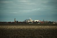
| colspan="3" align="center" style="background:silver"| [[File: | | colspan="3" align="center" style="background:silver"| [[File:Port de Dunkerque.jpg|400px]] | ||
|- | |- | ||
| ||style="background:Lavender"| | | ||style="background:Lavender"| | ||
| Line 28: | Line 28: | ||
= Rationale = | = Rationale = | ||
This case is a perfect illustration of the location of industries in a very natural landscape, where conflicts between the two exist and where compromises must constantly be found. | |||
Today, we can see that attempts are being made to protect certain areas in order to conserve the fauna and flora specific to this type of environment, while at the same time continuing to develop the port industry, which occupies an important part of the landscape, especially along the coast. It is therefore interesting to analyse this situation and find solutions to reconcile these different issues in the landscape. | |||
= Location and scope = | = Location and scope = | ||
''You can edit this map with the [[Special:MapEditor|map editor]]'' | ''You can edit this map with the [[Special:MapEditor|map editor]]'' | ||
{{#display_map: 51. | {{#display_map: 51.003046, 2.074032~Case study boundary west; 51.040957, 2.305579~Case study boundary east; | ||
}} | }} | ||
| Line 41: | Line 41: | ||
== A.1 Landscape layers and their system context == | == A.1 Landscape layers and their system context == | ||
=== Geomorphology, landscape units and coastal typology === | === Geomorphology, landscape units and coastal typology === | ||
From a geomorphological point of view, the territory has been influenced by two dominant factors: the maritime regime (the English Channel/North Sea) and hydrography. The area is part of the maritime or alluvial plain known as the Flemish maritime plain, which continues towards Belgium and the Netherlands. Its boundaries are defined by the former Aa delta. This type of geomorphological formation indicates that the area is highly marked and is changing noticeably as a result of the more or less rapid sedimentation phenomena. According to the geology map, we are faced with a recent Quaternary formation characterized by two fundamental typologies: dune formations and bay sealing sediments (sand and mud). The coastline has no hard formation at any point and is therefore very unstable on a human scale. | |||
To the north, the Channel's course narrows to only 35km, which has an influence on the sedimentary regimes. The foreshore is highly developed west of Dunkirk between 1000 and 1500m wide and the dune formations along the coastline reach 500 to 1000m wide. | To the north, the Channel's course narrows to only 35km, which has an influence on the sedimentary regimes. The foreshore is highly developed west of Dunkirk between 1000 and 1500m wide and the dune formations along the coastline reach 500 to 1000m wide. | ||
The morphology of the seabed influences the sedimentation and erosion mechanisms along the coast. The topography of the seabed is dominated by the presence of the Bancs de Flandres. They provide some protection for the coast by absorbing some of the energy of the swells. | The morphology of the seabed influences the sedimentation and erosion mechanisms along the coast. The topography of the seabed is dominated by the presence of the Bancs de Flandres. They provide some protection for the coast by absorbing some of the energy of the swells. | ||
| Line 56: | Line 56: | ||
They are characterized by a high ecological richness (ZNIEFF, SIC) and a landscape of meadows and sand dunes. | They are characterized by a high ecological richness (ZNIEFF, SIC) and a landscape of meadows and sand dunes. | ||
<gallery caption=" " widths="200px" heights="150px" perrow="5"> | <gallery caption=" " widths="200px" heights="150px" perrow="5"> | ||
File: | File:Unnamed.jpg| | ||
File: | File:Pasted image 0.png| | ||
File:Géopédo npdc.PNG| | |||
</gallery> | </gallery> | ||
=== Land use === | === Land use === | ||
The land use of West Dunkirk is mainly made up of two matrixes, which are almost equally distributed on the ground. The first matrix is an urban matrix. Compared to the urban matrices observed in Belgium, the French urban matrix is denser. Indeed, in the region of West Dunkirk , we find three denser urban poles <span style="color:red">(in red)</span> corresponding to Dunkerque in the East, Grand-Fort-Philippe and Gravelines in the West and Loon-Plage in the centre. As Dunkirk is the main town on this stretch of the coast, a sub-prefecture of the department of Northern France, it is the one that is experiencing the greatest sprawl with the addition of industrial and commercial zones <span style="color:#BF80FF>(in purple)</span> in its periphery. These areas, beyond the importance of the city of Dunkirk, have also developed due to the importance of the port of Dunkirk <span style="color:#B2B2B2>(in grey)</span> which has developed over almost all of this part of the coast. This port is an essential economic point for France since it provides a direct connection with Great Britain, but also because of its strong energy vocation. | |||
The rest of the surface area of this stretch of coast is essentially made up of an agricultural matrix <span style="color:#FFFF00>(in yellow)</span> composed of numerous small and complex plots of land, most of which are used for cereal crops. Although little represented on the whole territory, there is nevertheless a forest patch to the south-west of Dunkirk <span style="color:green">(in green)</span>. | |||
<gallery caption=" " widths="200px" heights="150px" perrow="5"> | <gallery caption=" " widths="200px" heights="150px" perrow="5"> | ||
File: | File:86800431 2754832294571180 2942692878599585792 o.jpg|''Crops & Industry'' | ||
File: | File:Coastal land use.jpg|''The Coastal Land Use of West Dunkirk'' | ||
File: | File:86766286 2754835341237542 2700167160705056768 o.jpg|''Land versus Sea'' | ||
</gallery> | </gallery> | ||
=== Green/blue infrastructure === | === Green/blue infrastructure === | ||
What are the major potential elements of a green/blue infrastructure network? | |||
Firstly, a green/blue infrastructure network is a natural and semi-natural network that provides services to humans. It is characterized by its multifunctionality, which makes it more cost-effective and resilient than grey infrastructure. The benefits of green/blue infrastructure are social, environmental and economic. | |||
“For example, a green infrastructure approach to stream networks can help filter and purify water for human use, reduce and manage stormwater runoff, provide attractive streamside landscapes, control flooding, reduce erosion and increase and maintain biological diversity” | |||
Dunkirk West is an area rich in blue infrastructure with a very important river system and many wetlands and permanent water areas. The main rivers that cross the area are: the Aa (channelled river), the Dunes Canal, the Bourbourg Canal (and its diversion) and the Oye River. Blue infrastructure is generally accompanied by green infrastructure, thus creating corridors that link several cores with a high concentration of functions (environmental, economic and societal). | |||
The functions of the green/blue infrastructure network: | |||
o Tourism: Platier D'Oye Nature Reserve (with Oye Beach) - Petit Fort Philippe Beach - Beach of Gravelines - Grand-Fort-Philippe Estran Park - Fort Vauban in Gravelines (Water Ditch). | |||
o Recreation: Beaches (Float, kitesurf, paddle, swimming, etc.) - Dunes (walk, observation, ect.) - Canals, river (promenade, navigation, ect.). | |||
o Maritime and river transport. | |||
o Heritage (historical interest): Fort Vauban in Gravelines (Water Ditch). | |||
o Biodiversity: diversity of habitats (including habitats conducive to avifauna) : Fine sand platform - “Green Beaches” (sandstone) - Shell bench - Salt grass herbarium - Wetlands (wet meadows, …) - Ponds - Afforestation - Thickets (dune beds) - Herbaceous wastelands - Mown or grazed grassland - Scattered halophilic vegetation on rocky embankments - Shaved sandy lawns - Salt/Sea Marshes (Foreshore with slikke and schorre) - Mud flats - Dunes. | |||
o Connectivity (corridors): Hedges - Wooded strips - Water system. | |||
o Water management (storm and river/sea => flood/overflow): wetlands absorb excess water, and dunes are natural dykes that hold marine waters. | |||
Are these likely to change/disappear? Why is that? | |||
These green/blue infrastructures are likely to change or even disappear. In fact, some have already changed. These changes may be due to the destruction, degradation, fragmentation and/or pollution of the environment. | |||
These are the result of the strong anthropic pressure that Dunkirk is experiencing (urbanisation, tourism, industrial development) and the regressive evolution of the coastline that is modifying the environment and the associated biodiversity. This regression of the coastline is causing the erosion of the dune belts. To counter this erosion, several structures are already in place such as groins, breakwaters, and traps at the foot of the dunes to encourage wind accumulation (example: Oye beach). | |||
Climate change is likely to accentuate the change or even the disappearance of certain environments and certain related species, particularly through rising water levels. | |||
<gallery caption=" " widths="200px" heights="150px" perrow="5"> | <gallery caption=" " widths="200px" heights="150px" perrow="5"> | ||
File: | File:Réseau hydrologique.jpg|''blue and green infrastructure network'' | ||
File: | File:Corine Land Cover - zones humides et surfaces en eaux permanentes (2015).jpg | ||
File:Harbour green and blue dunkerque.png | |||
</gallery> | </gallery> | ||
=== Actors and stakeholders === | === Actors and stakeholders === | ||
Our area covers the borough of Dunkirk as well as the borough of Saint-Omer. In this area, we are dealing with a group of municipalities called "Dunkerque Grand Littoral". This inter-municipal cooperation brings together 17 municipalities and its competences revolve around economic development, waste management, town planning, mobility and transport, energy, water management and sanitation, housing and roads. Finally, it intervenes in the fields of health, sport, justice, education, major risks and accessibility. This cooperative is managed by a President and its Vice-Presidents. This cooperation can therefore be considered as the leading player in the area. In the commune of Saint-Omer, which represents only a small part of our area, we find the Platier d'Oye national nature reserve. It is managed by the EDEN 62 mixed syndicate, which brings together, on an equal footing, elected members of the Departmental Council and local authorities. This syndicate is a will of the Pas-de-Calais Department and its missions are to protect, develop and raise awareness.' | Our area covers the borough of Dunkirk as well as the borough of Saint-Omer. At the European level, the European Commission has drafted numerous directives and laws to try to protect the coasts and shorelines. At the national level, we have the Conservatoire du Littoral which manages a third of its coastline. Our area covers the borough of Dunkirk as well as the borough of Saint-Omer. In this area, we are dealing with a group of municipalities called "Dunkerque Grand Littoral". This inter-municipal cooperation brings together 17 municipalities and its competences revolve around economic development, waste management, town planning, mobility and transport, energy, water management and sanitation, housing and roads. Finally, it intervenes in the fields of health, sport, justice, education, major risks and accessibility. This cooperative is managed by a President and its Vice-Presidents. This cooperation can therefore be considered as the leading player in the area. In the commune of Saint-Omer, which represents only a small part of our area, we find the Platier d'Oye national nature reserve. It is managed by the EDEN 62 mixed syndicate, which brings together, on an equal footing, elected members of the Departmental Council and local authorities. This syndicate is a will of the Pas-de-Calais Department and its missions are to protect, develop and raise awareness.' | ||
Then the second player would be represented by the various mayors of these 17 communes. They play a double role: ''state agent and commune agent''. As an ''agent of the state'', the mayor fulfils the following administrative functions: | Then the second player would be represented by the various mayors of these 17 communes. They play a double role: ''state agent and commune agent''. As an ''agent of the state'', the mayor fulfils the following administrative functions: | ||
| Line 105: | Line 132: | ||
=== Sacred spaces and heritage === | === Sacred spaces and heritage === | ||
We have listed here a number of places that have a cultural value to the people of Dunkirk. These places and elements bear witness to the past of the West of Dunkirk. | |||
1-'''The ruins of the old lock of Mardyck :''' | |||
Classified as a historical monument according to the decree of 18 June 1930. It was created in 1715 at the same time as the outlet canal to serve it. It was of great use before it was destroyed by the English and finally, the canal was filled in. | |||
2-'''The construction site of a ship in Tourville :''' | |||
The aim of this shipyard is to recreate a 17th century boat according to the techniques and tools of the time. | |||
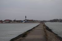
3-'''The lighthouse at Petit-Fort-Philippe :''' | |||
Built at the beginning of the 19th century, the lighthouse rises 30 meters above the ground. There are therefore 116 steps to climb to enjoy a panoramic view of the Dunkirk coast. | |||
4-'''Fort Vauban of Gravelines :''' | |||
In Gravelines, one can admire a fortified star signed by the military architect/engineer Vauban in the 17th century. The fort is classified as a Historic Monument. | |||
5-'''Belfry of Saint-Pol-sur-Mer :''' | |||
It was built in 2003 and is fairly recent. It has the four highest Jacquemarts in Europe, referring to important people of the city. The belfry is listed as a UNESCO World Heritage Site. | |||
6-'''Belfry of Gravelines :''' | |||
Dating from the 14th century, this belfry is listed as a UNESCO World Heritage Site. | |||
[[File:Able categorizing heritage elements according to centuries.jpg|thumb|table categorizing heritage elements according to centuries]] | |||
MUSEUMS: | |||
7-'''Museum of traditional games at Loon beach :''' | |||
The Galamé farm (former Flemish farmhouse) is the oldest dwelling in the city. This is where the museum of traditional games has been located since 2004. | |||
8-'''”Maison de la Mer” at Grand Fort Philippe :''' | |||
It is the only museum that provides an insight into the history and background of fishing in Iceland. | |||
9-'''Langevin Exhibition Centre in Grand-Synthe :''' | |||
This centre is made up of different associations: the Association of Former Miners, the Association of the Iron and Steel Industry and the Association for Development, Research and Study in the field of Archaeological and Paleontological Mineralogy. | |||
10-'''Museum of drawing and original print in Gravelines :''' | |||
It is the only French museum dedicated to printed works. It is located in the historical buildings of the Arsenal. | |||
11-'''Rescue house at Grand Fort Philippe :''' | |||
It recalls the prowess of rescuers at sea from photos, objects, etc.. | |||
[[File:Heritage distribution map.png|thumb|Heritage distribution map]] | |||
During our analysis, we noticed that heritage is mainly present in Dunkirk East because this is where the heart of the city of Dunkirk is located. However, we were able to identify about ten places or spaces representative of Dunkirk culture, west of the city centre. These include various museums of a unique character, architectural elements such as belfries listed as UNESCO World Heritage Sites, and a fortress designed by the architect/engineer Vauban. This list gives an idea of the marks left by the past that give a landscape identity to the various communes of Dunkirk West. | |||
<gallery caption=" " widths="200px" heights="150px" perrow="5"> | <gallery caption=" " widths="200px" heights="150px" perrow="5"> | ||
File: | File:The belfry of Gravelines.jpg|''The belfry of Gravelines'' | ||
File: | File:The Fort Vauban.jpg|''The Fort Vauban'' | ||
File: | File:The lighthouse of Petit Fort Philippe.jpg|''The lighthouse of Petit Fort Philippe'' | ||
</gallery> | </gallery> | ||
=== Visual appearance and landscape narrative === | === Visual appearance and landscape narrative === | ||
* | |||
* | * This landscape was represented by several Dunkirk painters such as Mathieu Elias and Philippe de Corbehem in the 17th century. However, it is more of interest to travellers. In the first half of the 19th century, Jean-Baptiste Camille Corot produced several Romantic-style oil paintings such as "Dunkerque, vue du port de pêche (1873)" or "Dunkerque plein air" which illustrate an idealized vision of fishing and small houses in the dunes as far as the eye can see. At the end of the century, there were still a few less numerous representations of the dune landscape such as the oil on canvas "Dunkerque" inspired by the Realism of Marie-Thérèse VanKerk. At the beginning of the 21st century, lighthouses become one of the most appreciated subjects in contemporary work. Thus, we find "Phare de Saint Pol" by Pascal Leroux in 2004, "Phare de Dunkerque" by Alain Depieretti in 2011 or "Phare Saint-pol" by Brigitte Bodo. | ||
* Some people have written about Dunkerque. In his epistolary account "France and Belgium, Alps and Pyrenees, travels and excursions" published after his death in 1892, Victor Hugo wrote letters to his wife Adèle, recounting his journey. In particular, he talks about his stay in Dunkirk. A second work "Dunkerque - Un port, des villes, un littoral, un siècle d'aventure urbaine" by Collectif Maurice Culot. | |||
* There is also a movie "Dunkirk" by Christopher Nolan, released in 2017, dealing with the Second World War, parts of which, particularly in the dunes, were shot in Dunkirk. This landscape inspire also singers like Alain Souchon in the song "Le Baiser". | |||
* The Dunkirk landscape was abundantly painted in the 18th century. There are numerous oil paintings in the Romantic style, depicting picturesque dune and maritime landscapes showing an idealized vision of fishing and life on the coast. In addition to painters, this landscape has also inspired poets, singers, and writers, such as Victor Hugo, during their visits. Over time, we notice that the subject matter of the works has changed to focus more on built and architectural elements such as the Saint-Pol lighthouse, which has been depicted several times in contemporary works. The Second World War played a very important role, loading the landscape with history. Several texts have been written on the subject and the better known film Dunkerque illustrates this event. Since the 19th century, the landscape has been much less represented. One can hypothesize that the establishment of industries has caused the picturesque side of the place to be lost. | |||
<gallery caption=" " widths="200px" heights="150px" perrow="5"> | <gallery caption=" " widths="200px" heights="150px" perrow="5"> | ||
File: | File:Dunkerque-plein-air-Jean-Baptiste-Camille-Corot.jpg|''Painting : Dunkerque plein air (1873) by Jean-Baptiste Camille Corot'' | ||
File: | File:Dunkerque-unportdesvillesunlittoralunsiecledaventureurbaine-collectifMauriceCulot.jpg|''Book : Dunkerque - Un port, des villes, un littoral, un siècle d'aventure urbaine (2000) by Collectif Maurice Culot'' | ||
File: | File:Dunkirk-Christopher-Nolan.jpg|''Movie : Dunkerque (2017) by Christopher Nolan'' | ||
</gallery> | </gallery> | ||
== A.2 Summary of your landscape system analysis and your development targets == | == A.2 Summary of your landscape system analysis and your development targets == | ||
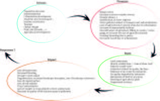
We found that the major drivers of our DPSIR model were related to urbanization and climate change and industry development. These different drivers put pressure on the coastal landscape, human well-being and the specific biodiversity in place. There is already fragmentation of the territory, a decrease in water and air quality, and strong erosion of the dune belt, which could worsen over the years without intervention to reduce these pressures. | |||
<gallery caption=" " widths="500px" heights="200px" perrow="5"> | |||
DPSI Dunk. West.jpg|''Our DPSIR Analysis''</gallery> | |||
The disappearance of natural areas affects the quality of life of the premises and therefore has an effect on point 3 "Good Health and Well-Being". | |||
Rising water levels can salinise the ground water on land and thus limit access to fresh water for cultivation. There is therefore an effect on point 6 "Clean Water and sanitation". | |||
The presence of oil platforms in the maritime environment and a major nuclear power plant shows us that energy from the coast is not green energy. However, it remains affordable in accordance with point 7 "Affordable and clean energy". | |||
In compliance with point 9 Industry, Innovation and Infrastructure', the port of Dunkirk continues to develop. However, this has a negative impact on point 11 "Sustainable cities and communities" since the extension of port activities tarnishes the landscape and makes it less attractive due to the concentration of functions and their lack of multiplicity. The region ends up being neglected because the coastline loses its attractiveness. Tourism also suffers from this loss of attractiveness and endangers point 15 "Life on Land". | |||
Point 13 "Climate Action" is one of the points most at risk. Indeed, little action is being taken on the coast, despite the climate emergency. The region is therefore suffering a loss of biodiversity (which also affects point 15 "Life on Land") due to the gradual disappearance of the dune barrier and the high risk of disappearance of wetlands of a special nature due to future submersion. Point 14 "Life Below Water" is also affected by river and sea traffic. The densification of this traffic due to the increase in the port goes against the recommendations of the UN. | |||
Finally, point 17 "Parnerships for the goals" may seem to be intact due to the establishment of a European Commission, but the lack of legislative power of the Commission and the lack of consistency in the way the coastal landscape of the different countries is treated (not the same legislation, not the same recommendations) endangers the coast as a whole. | |||
<gallery caption=" " widths="500px" heights="200px" perrow="5"> | <gallery caption=" " widths="500px" heights="200px" perrow="5"> | ||
File: | File:EN-SDG-Poster A4 0.jpg|''The Sustainable Development goals of ONU ©unesco.org'' | ||
</gallery> | </gallery> | ||
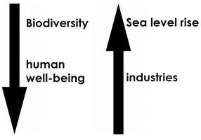
In relation to the analysis carried out according to the DPSIR model and in relation to the UN sustainable development objectives that have been observed to be at risk, we have identified two major issues concerning our territory. | |||
The first is related to the reduction of the natural environment and its loss of biodiversity. Indeed, due to the erosion of the dune barrier, the extension of the port, aggressive mobility and rising water levels, landscapes specific to this region are disappearing, leading to the disappearance of species typical to these environments. | |||
The second is more anthropogenic. The impoverishment of the quality of the environment, caused by the extension of the port and the coastal industry and a specialisation of functions (lack of diversity) impacts on human well-being and leads to a loss of interest in the region and in the development of its tourism. | |||
<gallery caption=" " widths="500px" heights="200px" perrow="5"> | <gallery caption=" " widths="500px" heights="200px" perrow="5"> | ||
File: | File:Hypothesis DunkirkWest.JPG|''There is therefore a decrease in biodiversity and human well-being to the benefit of the development of industries and the problems linked to sea level rise'' | ||
</gallery> | </gallery> | ||
Are there any initiatives taken for this landscape? Do you have a critical view on this? | |||
Platier d'Oye Nature Reserve : | |||
Against the erosion of the dunes: | |||
Spurs: Wooden piles aligned perpendicular to the sea whose role is to slow down the waves and promote the accumulation of sand on the beach. | |||
=> Questionable interest, because the transit parallel to the coast is mostly at the bottom of the beach. In addition, the waves go around the structures and attack the dune on both sides. | |||
Breakwaters: Wooden piles aligned parallel to the sea whose role is to break the waves. | |||
Large windbreaks : Piles connected by fascines installed at the foot of the dune in order to dampen the waves and encourage the accumulation of sand by both the sea and the wind, thus limiting the retreat of the dune barrier (mobilization of the sand as soon as the wind exceeds 20km/h). | |||
=> At the time of our visit of February 14, 2020, shortly after the storm Ciara of February 9, there were no more fascines and no accumulation of sand in the traps. Moreover, there was still a strong erosion of the dunes behind them. The effectiveness of these structures during heavy storms can therefore be questioned. | |||
Public Awareness : | |||
Creation of an information centre "la Maison dans la Dune". | |||
Eco-tourism: Tranquilisation of the area for birds and facilitation of discovery for the public (development of an educational trail). | |||
Ecological development of Dunkerque-Port: Various avoidance, reduction and compensation measures have been taken for the construction of the LNG terminal. Thus, certain areas of ecological interest and corridors have been preserved or even reinforced, and several protection measures as well as new developments in favour of biodiversity have been carried out: | |||
- Permanent land protection and conservation management of the power plant triangle site (grassed lawns, preservation of species stations). | |||
- Creation of two salt basins east of the Clipon | |||
- Land protection and conservation management of the dune site east of the Clipon and creation of wet depressions | |||
- Creation of freshwater lagoon-type wetlands | |||
In addition, with a view to resilient and sustainable territorial development, there is implementation of SDPN and management plans for areas reserved for the preservation of biodiversity. In this way, coherent and site-specific management plans are put in place. | |||
=> Critical? Despite the various measures for biodiversity, industrialization implies other consequent impacts, both direct and indirect, on the landscape. | |||
== A.3 Theory reflection == | == A.3 Theory reflection == | ||
'''International : Guiding Principles for Climate City Planning Action''' | |||
These guiding principles provide a common reference point. It permit to give a global response to climate change by curbing their greenhouse gas emissions and adapting to the effects of a changing climate mainly of cities. | |||
Organisation : | |||
• strengthening government capacity | |||
• involving local communities and multi-stakeholders | |||
• ensure transparency of the process of participation | |||
• choosing priorities actions over the short, medium and long term | |||
• developing a strategy | |||
Planning process : | |||
• Effective mitigation and realisation of baseline inventories and assessments | |||
• Ambitious target-setting and good synergies developing | |||
• on-going process and evaluation | |||
The result is the planning of climate action in cities through the creation of stand-alone plans or the integration of climate action into ongoing planning processes. | |||
'''EU : Water and Marine Policy''' | |||
On 12 March 2013, the commission adopted draft proposals for directives aimed at establishing a framework for maritime spatial planning and managing coastal integration, with a view to the sustainable development of coastal zones. This document thus contributes to the implementation of several other Community policies related to marine and coastal areas. These include, for example, the Habitats and Natura Directives and the Urban Strategy Framework Directive. Of course, there are many others. | |||
'''France : The Coastal Law''' | |||
The Coastal Law is a law adopted in 1986 by France that provides a framework for coastal development. It concerns nearly 1200 communes bordering the sea. In the face of urban pressure, erosion or marine submersion phenomena suffered by these territories, it attempts to reconcile preservation and development of the coastline. The main objectives of this law are to preserve natural areas, develop economic activities linked to the proximity of water, set up a graduated protection, allow a sustainable development of the territories, leave the possibility to adapt to the territory and reinforce research and innovation. | |||
== A.4 References == | == A.4 References == | ||
| Line 156: | Line 285: | ||
*''Which elements and phenomena need to be mapped, why and how?'' | *''Which elements and phenomena need to be mapped, why and how?'' | ||
*''This a text contribution, max 250 words'' | *''This a text contribution, max 250 words'' | ||
Based on our assumptions, we therefore assumed that there was a loss of biodiversity and a deterioration of human well-being for the benefit of industrial development and also caused by the rise in sea level. This is why we thought it would be interesting to make maps based on sea level rise, the evolution of the landscape over time and blue and green infrastructure in order to analyse the problems that could appear over time or be accentuated. The map of rising water levels would show us the parts of the territory that will be impacted. In terms of evolution over time, it would be interesting to see how the industrial landscape has evolved and how it might develop further. Finally, it is also interesting to analyze the green and blue structures to understand their impact on the landscape and the fragmentation that would exist within this landscape. | |||
== B.2 Mapping == | == B.2 Mapping == | ||
| Line 161: | Line 292: | ||
*''As a minimum, at least three different themes need to be mapped, you may choose more if needed'' | *''As a minimum, at least three different themes need to be mapped, you may choose more if needed'' | ||
'''Green and Blue Screen Mapping''' | |||
<gallery caption=" " widths="500px" heights="200px" perrow="1"> | |||
File:Dunkerque Ouest trame verte bleue light.jpg|''On a fairly large scale, the hydrological network appears to be very connected and very dense. It fragments the agricultural landscape into many small entities. Often accompanied by green infrastructure (hedges, grassy strips...) it contributes to a good connection of the ecological network. The green network, which is also fairly dense, seems more fragmented, but includes more extensive "pockets".'' | |||
</gallery> | |||
'''Mapping sea level rise''' | |||
<gallery caption=" " widths="500px" heights="200px" perrow="1"> | |||
File:Sea level rise to 1 meter.PNG|''This map shows the rise in water level for 1 meter of water level. The first thing you can see is that the polders are submerged. Secondly, it can be deduced that the presence of canals has influenced the advance of the water inland.'' | |||
File:Sea level rise to 25 metres.PNG|''This second map shows the disappearance of Dunkirk under a water rise of up to 25 metres.'' | |||
</gallery> | |||
'''Mapping of the evolution of industrialization/urbanization''' | |||
<gallery caption=" " widths="500px" heights="200px" perrow="1"> | <gallery caption=" " widths="500px" heights="200px" perrow="1"> | ||
File: | File:Évolution de l'urba.jpg|''This map shows the evolution of urbanisation between the 18 Century and Today. We see that the most important urbanisation is during the second half of the 20 century and around Dunkerque. This urbanisation is linked to the harbour activity. Until then the urbanisation has slowed this might be thanks to the littoral law of the French government which limits and regulates urbanization. We also observe that in the early age of this area the water managment was already important and influences the urbanisation.'' | ||
</gallery> | </gallery> | ||
| Line 171: | Line 312: | ||
* ''Draw a problems/potentials map'' | * ''Draw a problems/potentials map'' | ||
* ''Set priorities for the most relevant issues'' | * ''Set priorities for the most relevant issues'' | ||
First of all, there is an increase over time in the presence of industries in the landscape as well as in the nuclei of towns developing near them. This obviously has a significant impact on the landscape that we find today and which differs greatly from the one in place several decades or even hundreds of years ago. We can also observe that the hydrographic network seems very connected and very dense. It breaks up the agricultural landscape into many small entities. Often accompanied by green infrastructures (hedges, grassy strips...) it contributes to a good connection of the ecological network. The green network, which is also fairly dense, seems more fragmented, but includes more extensive "pockets". All this blue grid favours the entry of water into the land and may therefore be a problem in the future. | |||
As a result, there is, above all, a fairly significant potential rise in sea level in future years. This will obviously have consequences on the current landscape and it will be important to think about future developments that will be adequate to adapt to this problem. This is, in our opinion, the biggest problem to be dealt with here for our area. | |||
<gallery caption=" " widths="500px" heights="200px" perrow="5"> | <gallery caption=" " widths="500px" heights="200px" perrow="5"> | ||
| Line 177: | Line 321: | ||
== B.4 Theory reflection == | == B.4 Theory reflection == | ||
'''The BEAT : The Bluehealth Environmental Assessment Tool''' | |||
It is important to be able to make effective linkages at the planning and design level to enable people to access water and enjoy the many health and wellness benefits associated with these blue spaces. The Bluehealth Environmental Assessment Tool (BEAT) provides a comprehensive method for assessing all relevant areas related to "blue spaces" (any outdoor space where water is obviously present and that people can experience, whether through direct contact in, on or near water, or through indirect means such as seeing it). The tool is primarily designed to identify the extent to which a particular blue space offers opportunities for exposure to water, but also the possible impacts on the environment itself. It can be used as a means of collecting data for monitoring purposes, as a starting point for a planning and design project aimed at improving, restoring or providing new access to seaside landscapes, or as a post-occupation assessment of a constructed project. It is therefore of interest in our area since we encounter many blue infrastructures and issues related to them. | |||
'''An Approach to Landscape Character Assessment''' | |||
This method helps us all to conserve, enhance, restore and regenerate landscapes and link environmental, social and economic challenge. For instance, it permits to describe a landscape, to give spatial reference, to define the sense of place and special qualities, to help to decision making. The users of this approach are all those who may have a direct (local authorities, users and inhabitants of the landscape) or indirect (policies) link with the land or seascape. | |||
First we have to define the purpose and then to do desk study. Based on these informations, we have to plan field survey. Then identify the landscape character and key characteristics. | |||
This method is implemented by cartographic tools. | |||
[[File:Landscape assessment.JPG|thumb|What is a landscape ; environmental, aesthetic ans social challenge]] | |||
'''The Seascape Character Assessment''' | |||
The seascape character assessment provides a comprehensive and accurate overview of seascapes by following the principles of Landscape Character Assessment. The interest of this assessment is to obtain a description of the coastal and seascapes, which allows, among other things, an overview of the coastal landscape at all its scales. In addition, awareness of coastal landscapes will contribute to the search for solutions for sustainable development issues in the future. | |||
== B.5 References == | == B.5 References == | ||
Latest revision as of 13:21, 17 March 2020
>>>back to working groups overview
| Area | Dunkerque West | |
| Place | Dunkerque, department of Nord and the Nord-Pas-de-Calais region | |
| Country | France | |
| Topics | industrisation + port activities, specific ecosystems, climate change | |
| Author(s) | Anouchka Secol, Molly Verougstraete, Isadora Grumiaux, Julien Zirpolo, Alice Chanu, Camille Picherie, Ondine Boulanger | |

| ||
Rationale
This case is a perfect illustration of the location of industries in a very natural landscape, where conflicts between the two exist and where compromises must constantly be found. Today, we can see that attempts are being made to protect certain areas in order to conserve the fauna and flora specific to this type of environment, while at the same time continuing to develop the port industry, which occupies an important part of the landscape, especially along the coast. It is therefore interesting to analyse this situation and find solutions to reconcile these different issues in the landscape.
Location and scope
You can edit this map with the map editor
A Landscape System Analysis
A.1 Landscape layers and their system context
Geomorphology, landscape units and coastal typology
From a geomorphological point of view, the territory has been influenced by two dominant factors: the maritime regime (the English Channel/North Sea) and hydrography. The area is part of the maritime or alluvial plain known as the Flemish maritime plain, which continues towards Belgium and the Netherlands. Its boundaries are defined by the former Aa delta. This type of geomorphological formation indicates that the area is highly marked and is changing noticeably as a result of the more or less rapid sedimentation phenomena. According to the geology map, we are faced with a recent Quaternary formation characterized by two fundamental typologies: dune formations and bay sealing sediments (sand and mud). The coastline has no hard formation at any point and is therefore very unstable on a human scale. To the north, the Channel's course narrows to only 35km, which has an influence on the sedimentary regimes. The foreshore is highly developed west of Dunkirk between 1000 and 1500m wide and the dune formations along the coastline reach 500 to 1000m wide. The morphology of the seabed influences the sedimentation and erosion mechanisms along the coast. The topography of the seabed is dominated by the presence of the Bancs de Flandres. They provide some protection for the coast by absorbing some of the energy of the swells. The evolution of the coastline is due to erosion and sedimentation phenomena, whether natural (wind, swell, tide) or anthropogenic (dyke, urbanisation, canal, etc.). From Calais to Dunkirk, the coastline has tended to become rather fatter, with the shoreline growing by around 500 m over the last 300 or 400 centuries. This is due to several factors, including the welding to the shore of the sandy banks encountered in front of the coastline. In particular, the closure of the Mardyck channel, which was favoured by the construction of the Dunkirk jetties, has led to a significant advance in the shoreline. The current coastal regime is, to a large extent, the legacy of changes in the seabed and coastline that have taken place during these sea level variations.
On the coast, swells have a predominant action on sedimentation, while offshore, currents have a predominant action on sedimentation. The action of the swells is translated by a lateral transport (coastal transit) but also by a sorting in the profile which results in a decrease of the granulometry of the coast to the bottom. The distribution is done as such: where the currents are strongest, the materials are the largest and where they are weakest, the sediments are the finest.
The progression of the coastline to the east is the result of a natural phenomenon accentuated by the construction of dykes in order to gain land. The harbour piers, which acted as groynes, prevented the movement of sediment and caused the beaches east of Dunkirk to become thinner and west to become fatter. Over time the surface area of the dune cord has shrunk considerably. The development of urbanization is the main cause (40%). The remaining dunes have also lost height. From the landscape point of view, this maritime plain, also called "Bootland" (bare country), is characterized by a little marked relief whose altitude is lower than 5m for the majority. The landscape is open and strongly exposed to the wind, added to its agronomic richness, there is little afforestation. There are therefore large areas of open cultivation, beets, chicory, flax, vegetables and cereals. It is criss-crossed by polders and an extensive network of canals whose flow is constantly regulated. It is separated from the North Sea by a dune strip. This physical characteristic explains the ease of urban development (no relief hindrance). The natural orientation of the territory thus dictates the organisation of human settlements, which are part of this network (infrastructures, urbanisation, etc.). There are two major landscape entities: the dune belt and the channelled maritime plain. The channelled maritime plain is the result of strong human intervention in its environment. In the Middle Ages, the plain was polderised, then the marshes were drained from the 12th century onwards through the setting up of the watering system. From the period when the territory was only sea, the landscape keeps strong characteristics: the horizons, the wind, the presence of water, which make it a landscape in transition, between land and sea. Successive urbanisations, the installation of port facilities on the seafront, the development of infrastructures, have modified the legibility of these large geographical entities, thus introducing strong ruptures.
The beach and dune areas bear witness to the original landscape of the seafront. They are characterized by a high ecological richness (ZNIEFF, SIC) and a landscape of meadows and sand dunes.


Land use
The land use of West Dunkirk is mainly made up of two matrixes, which are almost equally distributed on the ground. The first matrix is an urban matrix. Compared to the urban matrices observed in Belgium, the French urban matrix is denser. Indeed, in the region of West Dunkirk , we find three denser urban poles (in red) corresponding to Dunkerque in the East, Grand-Fort-Philippe and Gravelines in the West and Loon-Plage in the centre. As Dunkirk is the main town on this stretch of the coast, a sub-prefecture of the department of Northern France, it is the one that is experiencing the greatest sprawl with the addition of industrial and commercial zones (in purple) in its periphery. These areas, beyond the importance of the city of Dunkirk, have also developed due to the importance of the port of Dunkirk (in grey) which has developed over almost all of this part of the coast. This port is an essential economic point for France since it provides a direct connection with Great Britain, but also because of its strong energy vocation. The rest of the surface area of this stretch of coast is essentially made up of an agricultural matrix (in yellow) composed of numerous small and complex plots of land, most of which are used for cereal crops. Although little represented on the whole territory, there is nevertheless a forest patch to the south-west of Dunkirk (in green).
-
 Crops & Industry
 -
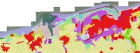 The Coastal Land Use of West Dunkirk
 -
 Land versus Sea


Green/blue infrastructure
What are the major potential elements of a green/blue infrastructure network?
Firstly, a green/blue infrastructure network is a natural and semi-natural network that provides services to humans. It is characterized by its multifunctionality, which makes it more cost-effective and resilient than grey infrastructure. The benefits of green/blue infrastructure are social, environmental and economic. “For example, a green infrastructure approach to stream networks can help filter and purify water for human use, reduce and manage stormwater runoff, provide attractive streamside landscapes, control flooding, reduce erosion and increase and maintain biological diversity”
Dunkirk West is an area rich in blue infrastructure with a very important river system and many wetlands and permanent water areas. The main rivers that cross the area are: the Aa (channelled river), the Dunes Canal, the Bourbourg Canal (and its diversion) and the Oye River. Blue infrastructure is generally accompanied by green infrastructure, thus creating corridors that link several cores with a high concentration of functions (environmental, economic and societal). The functions of the green/blue infrastructure network:
o Tourism: Platier D'Oye Nature Reserve (with Oye Beach) - Petit Fort Philippe Beach - Beach of Gravelines - Grand-Fort-Philippe Estran Park - Fort Vauban in Gravelines (Water Ditch).
o Recreation: Beaches (Float, kitesurf, paddle, swimming, etc.) - Dunes (walk, observation, ect.) - Canals, river (promenade, navigation, ect.).
o Maritime and river transport.
o Heritage (historical interest): Fort Vauban in Gravelines (Water Ditch).
o Biodiversity: diversity of habitats (including habitats conducive to avifauna) : Fine sand platform - “Green Beaches” (sandstone) - Shell bench - Salt grass herbarium - Wetlands (wet meadows, …) - Ponds - Afforestation - Thickets (dune beds) - Herbaceous wastelands - Mown or grazed grassland - Scattered halophilic vegetation on rocky embankments - Shaved sandy lawns - Salt/Sea Marshes (Foreshore with slikke and schorre) - Mud flats - Dunes.
o Connectivity (corridors): Hedges - Wooded strips - Water system.
o Water management (storm and river/sea => flood/overflow): wetlands absorb excess water, and dunes are natural dykes that hold marine waters.
Are these likely to change/disappear? Why is that?
These green/blue infrastructures are likely to change or even disappear. In fact, some have already changed. These changes may be due to the destruction, degradation, fragmentation and/or pollution of the environment. These are the result of the strong anthropic pressure that Dunkirk is experiencing (urbanisation, tourism, industrial development) and the regressive evolution of the coastline that is modifying the environment and the associated biodiversity. This regression of the coastline is causing the erosion of the dune belts. To counter this erosion, several structures are already in place such as groins, breakwaters, and traps at the foot of the dunes to encourage wind accumulation (example: Oye beach). Climate change is likely to accentuate the change or even the disappearance of certain environments and certain related species, particularly through rising water levels.
-
 blue and green infrastructure network
 -
-

.jpg)

Actors and stakeholders
Our area covers the borough of Dunkirk as well as the borough of Saint-Omer. At the European level, the European Commission has drafted numerous directives and laws to try to protect the coasts and shorelines. At the national level, we have the Conservatoire du Littoral which manages a third of its coastline. Our area covers the borough of Dunkirk as well as the borough of Saint-Omer. In this area, we are dealing with a group of municipalities called "Dunkerque Grand Littoral". This inter-municipal cooperation brings together 17 municipalities and its competences revolve around economic development, waste management, town planning, mobility and transport, energy, water management and sanitation, housing and roads. Finally, it intervenes in the fields of health, sport, justice, education, major risks and accessibility. This cooperative is managed by a President and its Vice-Presidents. This cooperation can therefore be considered as the leading player in the area. In the commune of Saint-Omer, which represents only a small part of our area, we find the Platier d'Oye national nature reserve. It is managed by the EDEN 62 mixed syndicate, which brings together, on an equal footing, elected members of the Departmental Council and local authorities. This syndicate is a will of the Pas-de-Calais Department and its missions are to protect, develop and raise awareness.'
Then the second player would be represented by the various mayors of these 17 communes. They play a double role: state agent and commune agent. As an agent of the state, the mayor fulfils the following administrative functions: - the publication of laws and regulations - the organisation of elections - the legalization of signatures. It may be responsible for the execution of general security measures. As an agent of the municipality, he is responsible for the execution of the decisions of the municipal council and acts under the control of this council. He represents the municipality in court, awards contracts, signs contracts, prepares the budget, and manages the assets. In the area of town planning, he issues building permits and other town planning authorisations on behalf of the municipality. By its municipal by-laws, it can regulate traffic, parking, bathing and navigation in its municipality or prescribe works in case of endangerment of the population or the environment.
Finally, the third and last actor is the people living and working in the area, not forgetting tourists. Thus, we find the port of Dunkirk and all the workers associated with it. It should be noted that this port is classified as France's 3rd largest port, renowned as a port for large bulk goods destined for its many industrial establishments. In other words, it plays an essential role in the landscape. There are also many commercial zones within our study area, which also impact the landscape. The farmers who structure the landscape with their plots of land cannot be overlooked either. Finally, let us not forget of course the inhabitants who live the landscape on a daily basis, as well as the tourists who impact the landscape to a greater or lesser extent depending on their presence.
So it can therefore be said here that it is the inhabitants and workers (mainly farmers) who are affected by the changes made to the landscape. Nor should we forget the local fauna and flora that depend on the actions initiated in the landscape. Hence the importance of having protected areas such as the Platier d'Oye Nature Reserve.
-
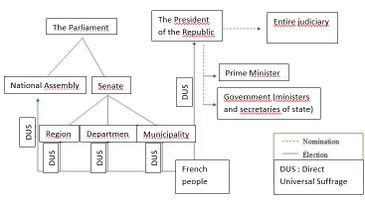 How the french republic works
 -
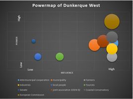 Power Map of western Dunkirk


Sacred spaces and heritage
We have listed here a number of places that have a cultural value to the people of Dunkirk. These places and elements bear witness to the past of the West of Dunkirk.
1-The ruins of the old lock of Mardyck : Classified as a historical monument according to the decree of 18 June 1930. It was created in 1715 at the same time as the outlet canal to serve it. It was of great use before it was destroyed by the English and finally, the canal was filled in.
2-The construction site of a ship in Tourville : The aim of this shipyard is to recreate a 17th century boat according to the techniques and tools of the time.
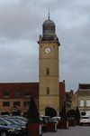
3-The lighthouse at Petit-Fort-Philippe : Built at the beginning of the 19th century, the lighthouse rises 30 meters above the ground. There are therefore 116 steps to climb to enjoy a panoramic view of the Dunkirk coast.
4-Fort Vauban of Gravelines : In Gravelines, one can admire a fortified star signed by the military architect/engineer Vauban in the 17th century. The fort is classified as a Historic Monument.
5-Belfry of Saint-Pol-sur-Mer : It was built in 2003 and is fairly recent. It has the four highest Jacquemarts in Europe, referring to important people of the city. The belfry is listed as a UNESCO World Heritage Site.
6-Belfry of Gravelines : Dating from the 14th century, this belfry is listed as a UNESCO World Heritage Site.

MUSEUMS:
7-Museum of traditional games at Loon beach : The Galamé farm (former Flemish farmhouse) is the oldest dwelling in the city. This is where the museum of traditional games has been located since 2004.
8-”Maison de la Mer” at Grand Fort Philippe : It is the only museum that provides an insight into the history and background of fishing in Iceland.
9-Langevin Exhibition Centre in Grand-Synthe : This centre is made up of different associations: the Association of Former Miners, the Association of the Iron and Steel Industry and the Association for Development, Research and Study in the field of Archaeological and Paleontological Mineralogy.
10-Museum of drawing and original print in Gravelines : It is the only French museum dedicated to printed works. It is located in the historical buildings of the Arsenal.
11-Rescue house at Grand Fort Philippe : It recalls the prowess of rescuers at sea from photos, objects, etc..

During our analysis, we noticed that heritage is mainly present in Dunkirk East because this is where the heart of the city of Dunkirk is located. However, we were able to identify about ten places or spaces representative of Dunkirk culture, west of the city centre. These include various museums of a unique character, architectural elements such as belfries listed as UNESCO World Heritage Sites, and a fortress designed by the architect/engineer Vauban. This list gives an idea of the marks left by the past that give a landscape identity to the various communes of Dunkirk West.
-
 The belfry of Gravelines
 -
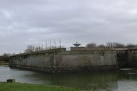 The Fort Vauban
 -
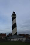 The lighthouse of Petit Fort Philippe


Visual appearance and landscape narrative
- This landscape was represented by several Dunkirk painters such as Mathieu Elias and Philippe de Corbehem in the 17th century. However, it is more of interest to travellers. In the first half of the 19th century, Jean-Baptiste Camille Corot produced several Romantic-style oil paintings such as "Dunkerque, vue du port de pêche (1873)" or "Dunkerque plein air" which illustrate an idealized vision of fishing and small houses in the dunes as far as the eye can see. At the end of the century, there were still a few less numerous representations of the dune landscape such as the oil on canvas "Dunkerque" inspired by the Realism of Marie-Thérèse VanKerk. At the beginning of the 21st century, lighthouses become one of the most appreciated subjects in contemporary work. Thus, we find "Phare de Saint Pol" by Pascal Leroux in 2004, "Phare de Dunkerque" by Alain Depieretti in 2011 or "Phare Saint-pol" by Brigitte Bodo.
- Some people have written about Dunkerque. In his epistolary account "France and Belgium, Alps and Pyrenees, travels and excursions" published after his death in 1892, Victor Hugo wrote letters to his wife Adèle, recounting his journey. In particular, he talks about his stay in Dunkirk. A second work "Dunkerque - Un port, des villes, un littoral, un siècle d'aventure urbaine" by Collectif Maurice Culot.
- There is also a movie "Dunkirk" by Christopher Nolan, released in 2017, dealing with the Second World War, parts of which, particularly in the dunes, were shot in Dunkirk. This landscape inspire also singers like Alain Souchon in the song "Le Baiser".
- The Dunkirk landscape was abundantly painted in the 18th century. There are numerous oil paintings in the Romantic style, depicting picturesque dune and maritime landscapes showing an idealized vision of fishing and life on the coast. In addition to painters, this landscape has also inspired poets, singers, and writers, such as Victor Hugo, during their visits. Over time, we notice that the subject matter of the works has changed to focus more on built and architectural elements such as the Saint-Pol lighthouse, which has been depicted several times in contemporary works. The Second World War played a very important role, loading the landscape with history. Several texts have been written on the subject and the better known film Dunkerque illustrates this event. Since the 19th century, the landscape has been much less represented. One can hypothesize that the establishment of industries has caused the picturesque side of the place to be lost.
-
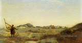 Painting : Dunkerque plein air (1873) by Jean-Baptiste Camille Corot
 -
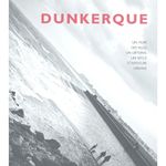 Book : Dunkerque - Un port, des villes, un littoral, un siècle d'aventure urbaine (2000) by Collectif Maurice Culot
 -
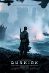 Movie : Dunkerque (2017) by Christopher Nolan


A.2 Summary of your landscape system analysis and your development targets
We found that the major drivers of our DPSIR model were related to urbanization and climate change and industry development. These different drivers put pressure on the coastal landscape, human well-being and the specific biodiversity in place. There is already fragmentation of the territory, a decrease in water and air quality, and strong erosion of the dune belt, which could worsen over the years without intervention to reduce these pressures.
-
 Our DPSIR Analysis

The disappearance of natural areas affects the quality of life of the premises and therefore has an effect on point 3 "Good Health and Well-Being". Rising water levels can salinise the ground water on land and thus limit access to fresh water for cultivation. There is therefore an effect on point 6 "Clean Water and sanitation". The presence of oil platforms in the maritime environment and a major nuclear power plant shows us that energy from the coast is not green energy. However, it remains affordable in accordance with point 7 "Affordable and clean energy". In compliance with point 9 Industry, Innovation and Infrastructure', the port of Dunkirk continues to develop. However, this has a negative impact on point 11 "Sustainable cities and communities" since the extension of port activities tarnishes the landscape and makes it less attractive due to the concentration of functions and their lack of multiplicity. The region ends up being neglected because the coastline loses its attractiveness. Tourism also suffers from this loss of attractiveness and endangers point 15 "Life on Land". Point 13 "Climate Action" is one of the points most at risk. Indeed, little action is being taken on the coast, despite the climate emergency. The region is therefore suffering a loss of biodiversity (which also affects point 15 "Life on Land") due to the gradual disappearance of the dune barrier and the high risk of disappearance of wetlands of a special nature due to future submersion. Point 14 "Life Below Water" is also affected by river and sea traffic. The densification of this traffic due to the increase in the port goes against the recommendations of the UN. Finally, point 17 "Parnerships for the goals" may seem to be intact due to the establishment of a European Commission, but the lack of legislative power of the Commission and the lack of consistency in the way the coastal landscape of the different countries is treated (not the same legislation, not the same recommendations) endangers the coast as a whole.
-
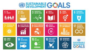 The Sustainable Development goals of ONU ©unesco.org

In relation to the analysis carried out according to the DPSIR model and in relation to the UN sustainable development objectives that have been observed to be at risk, we have identified two major issues concerning our territory. The first is related to the reduction of the natural environment and its loss of biodiversity. Indeed, due to the erosion of the dune barrier, the extension of the port, aggressive mobility and rising water levels, landscapes specific to this region are disappearing, leading to the disappearance of species typical to these environments. The second is more anthropogenic. The impoverishment of the quality of the environment, caused by the extension of the port and the coastal industry and a specialisation of functions (lack of diversity) impacts on human well-being and leads to a loss of interest in the region and in the development of its tourism.
-
 There is therefore a decrease in biodiversity and human well-being to the benefit of the development of industries and the problems linked to sea level rise

Are there any initiatives taken for this landscape? Do you have a critical view on this?
Platier d'Oye Nature Reserve : Against the erosion of the dunes: Spurs: Wooden piles aligned perpendicular to the sea whose role is to slow down the waves and promote the accumulation of sand on the beach. => Questionable interest, because the transit parallel to the coast is mostly at the bottom of the beach. In addition, the waves go around the structures and attack the dune on both sides. Breakwaters: Wooden piles aligned parallel to the sea whose role is to break the waves. Large windbreaks : Piles connected by fascines installed at the foot of the dune in order to dampen the waves and encourage the accumulation of sand by both the sea and the wind, thus limiting the retreat of the dune barrier (mobilization of the sand as soon as the wind exceeds 20km/h). => At the time of our visit of February 14, 2020, shortly after the storm Ciara of February 9, there were no more fascines and no accumulation of sand in the traps. Moreover, there was still a strong erosion of the dunes behind them. The effectiveness of these structures during heavy storms can therefore be questioned. Public Awareness : Creation of an information centre "la Maison dans la Dune". Eco-tourism: Tranquilisation of the area for birds and facilitation of discovery for the public (development of an educational trail).
Ecological development of Dunkerque-Port: Various avoidance, reduction and compensation measures have been taken for the construction of the LNG terminal. Thus, certain areas of ecological interest and corridors have been preserved or even reinforced, and several protection measures as well as new developments in favour of biodiversity have been carried out:
- Permanent land protection and conservation management of the power plant triangle site (grassed lawns, preservation of species stations).
- Creation of two salt basins east of the Clipon
- Land protection and conservation management of the dune site east of the Clipon and creation of wet depressions
- Creation of freshwater lagoon-type wetlands
In addition, with a view to resilient and sustainable territorial development, there is implementation of SDPN and management plans for areas reserved for the preservation of biodiversity. In this way, coherent and site-specific management plans are put in place. => Critical? Despite the various measures for biodiversity, industrialization implies other consequent impacts, both direct and indirect, on the landscape.
A.3 Theory reflection
International : Guiding Principles for Climate City Planning Action These guiding principles provide a common reference point. It permit to give a global response to climate change by curbing their greenhouse gas emissions and adapting to the effects of a changing climate mainly of cities.
Organisation : • strengthening government capacity • involving local communities and multi-stakeholders • ensure transparency of the process of participation • choosing priorities actions over the short, medium and long term • developing a strategy
Planning process : • Effective mitigation and realisation of baseline inventories and assessments • Ambitious target-setting and good synergies developing • on-going process and evaluation
The result is the planning of climate action in cities through the creation of stand-alone plans or the integration of climate action into ongoing planning processes.
EU : Water and Marine Policy
On 12 March 2013, the commission adopted draft proposals for directives aimed at establishing a framework for maritime spatial planning and managing coastal integration, with a view to the sustainable development of coastal zones. This document thus contributes to the implementation of several other Community policies related to marine and coastal areas. These include, for example, the Habitats and Natura Directives and the Urban Strategy Framework Directive. Of course, there are many others.
France : The Coastal Law
The Coastal Law is a law adopted in 1986 by France that provides a framework for coastal development. It concerns nearly 1200 communes bordering the sea. In the face of urban pressure, erosion or marine submersion phenomena suffered by these territories, it attempts to reconcile preservation and development of the coastline. The main objectives of this law are to preserve natural areas, develop economic activities linked to the proximity of water, set up a graduated protection, allow a sustainable development of the territories, leave the possibility to adapt to the territory and reinforce research and innovation.
A.4 References
- give a full list of the references you have used for this section
Phase B: Landscape Evaluation and Assessment
B.1 Assessment Strategy
- Based on the hypothesis derived from your previous landscape systems analysis you are now asked to define the goals for assessing the landscape. Your assessment is the basis for evaluating the landscape status.
- Which elements and phenomena need to be mapped, why and how?
- This a text contribution, max 250 words
Based on our assumptions, we therefore assumed that there was a loss of biodiversity and a deterioration of human well-being for the benefit of industrial development and also caused by the rise in sea level. This is why we thought it would be interesting to make maps based on sea level rise, the evolution of the landscape over time and blue and green infrastructure in order to analyse the problems that could appear over time or be accentuated. The map of rising water levels would show us the parts of the territory that will be impacted. In terms of evolution over time, it would be interesting to see how the industrial landscape has evolved and how it might develop further. Finally, it is also interesting to analyze the green and blue structures to understand their impact on the landscape and the fragmentation that would exist within this landscape.
B.2 Mapping
- As defined by your assessment strategy you conduct the mapping and present your findings here
- As a minimum, at least three different themes need to be mapped, you may choose more if needed
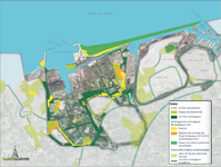
Green and Blue Screen Mapping
-
 On a fairly large scale, the hydrological network appears to be very connected and very dense. It fragments the agricultural landscape into many small entities. Often accompanied by green infrastructure (hedges, grassy strips...) it contributes to a good connection of the ecological network. The green network, which is also fairly dense, seems more fragmented, but includes more extensive "pockets".

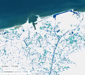
Mapping sea level rise
-
 This map shows the rise in water level for 1 meter of water level. The first thing you can see is that the polders are submerged. Secondly, it can be deduced that the presence of canals has influenced the advance of the water inland.
 -
 This second map shows the disappearance of Dunkirk under a water rise of up to 25 metres.


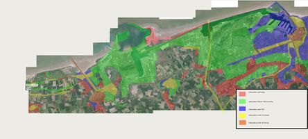
Mapping of the evolution of industrialization/urbanization
-
 This map shows the evolution of urbanisation between the 18 Century and Today. We see that the most important urbanisation is during the second half of the 20 century and around Dunkerque. This urbanisation is linked to the harbour activity. Until then the urbanisation has slowed this might be thanks to the littoral law of the French government which limits and regulates urbanization. We also observe that in the early age of this area the water managment was already important and influences the urbanisation.

B.3 Problem definition and priority setting
- Give a summary of the major findings of your mapping process, what are the problems/potentials identified?
- Draw a problems/potentials map
- Set priorities for the most relevant issues
First of all, there is an increase over time in the presence of industries in the landscape as well as in the nuclei of towns developing near them. This obviously has a significant impact on the landscape that we find today and which differs greatly from the one in place several decades or even hundreds of years ago. We can also observe that the hydrographic network seems very connected and very dense. It breaks up the agricultural landscape into many small entities. Often accompanied by green infrastructures (hedges, grassy strips...) it contributes to a good connection of the ecological network. The green network, which is also fairly dense, seems more fragmented, but includes more extensive "pockets". All this blue grid favours the entry of water into the land and may therefore be a problem in the future. As a result, there is, above all, a fairly significant potential rise in sea level in future years. This will obviously have consequences on the current landscape and it will be important to think about future developments that will be adequate to adapt to this problem. This is, in our opinion, the biggest problem to be dealt with here for our area.
-
add caption here
B.4 Theory reflection
The BEAT : The Bluehealth Environmental Assessment Tool
It is important to be able to make effective linkages at the planning and design level to enable people to access water and enjoy the many health and wellness benefits associated with these blue spaces. The Bluehealth Environmental Assessment Tool (BEAT) provides a comprehensive method for assessing all relevant areas related to "blue spaces" (any outdoor space where water is obviously present and that people can experience, whether through direct contact in, on or near water, or through indirect means such as seeing it). The tool is primarily designed to identify the extent to which a particular blue space offers opportunities for exposure to water, but also the possible impacts on the environment itself. It can be used as a means of collecting data for monitoring purposes, as a starting point for a planning and design project aimed at improving, restoring or providing new access to seaside landscapes, or as a post-occupation assessment of a constructed project. It is therefore of interest in our area since we encounter many blue infrastructures and issues related to them.
An Approach to Landscape Character Assessment
This method helps us all to conserve, enhance, restore and regenerate landscapes and link environmental, social and economic challenge. For instance, it permits to describe a landscape, to give spatial reference, to define the sense of place and special qualities, to help to decision making. The users of this approach are all those who may have a direct (local authorities, users and inhabitants of the landscape) or indirect (policies) link with the land or seascape.
First we have to define the purpose and then to do desk study. Based on these informations, we have to plan field survey. Then identify the landscape character and key characteristics. This method is implemented by cartographic tools.

The Seascape Character Assessment
The seascape character assessment provides a comprehensive and accurate overview of seascapes by following the principles of Landscape Character Assessment. The interest of this assessment is to obtain a description of the coastal and seascapes, which allows, among other things, an overview of the coastal landscape at all its scales. In addition, awareness of coastal landscapes will contribute to the search for solutions for sustainable development issues in the future.
B.5 References
- give a full list of the references you have used for this section
Phase C – Strategy and Master Plan
C.1 Goal Setting
- Define strategic planning objectives based on the evaluation findings
- Link back to your original targets from section one and the Development Goals
- 150 words text contribution
C.2 Spatial Strategy and Transect
- translate your strategic goals into a vision
- develop a spatial translation of your vision
- exemplify your vision in the form of a transect with concrete interventions
- add map(s) and visualizations
-
add caption here
-
add caption here
-
add caption here
-
add caption here
C.3 From Theory of Change to Implementation
- For implementing your vision: Which partnerships are needed? Which governance model is required?
- Who needs to act and how? Draw and explain a change/process model/timeline
- Which resources are needed? On which assets can you build?
- add 150 words text and visuals
-
add caption here
-
add caption here
C.4 References
- give a full list of the references you have used for this section
D. Process Reflection
- Reflect in your intercultural and interdisciplinary team on the outcomes of your study
- Which limitations were you facing?
- What have you learnt from each other?
- What would you do differently next time?
- You can also use diagrams/visuals
- 250 words text