COLAND Case Study 2020 - Reiu: Difference between revisions
| (117 intermediate revisions by 2 users not shown) | |||
| Line 33: | Line 33: | ||
''You can edit this map with the [[Special:MapEditor|map editor]]'' | ''You can edit this map with the [[Special:MapEditor|map editor]]'' | ||
{{#display_map: 58. | {{#display_map: | ||
|lines=58.29123179894238,24.59665848380774:58.29411889838185,24.604554907147584:58.29628406842865,24.609018102948365:58.2991707557901,24.60936142570227:58.303500345354514,24.61039139396399:58.305664941482576,24.60936142570227:58.311436550404984,24.60489822990149:58.31612528930494,24.60215164787024:58.32333752007013,24.599061743085084:58.32586145330872,24.598031774823365:58.327123352357226,24.603524938885865:58.32928650306893,24.60592819816321:58.33253098093557,24.608331457440553:58.34046067305519,24.61142136222571:58.3494695269834,24.614511267010865:58.35777956550077,24.60190586010706:58.35759945332795,24.57415407474496:58.36039108875725,24.568317587928554:58.36318250345279,24.562824423866054:58.355708220039304,24.54565828617074:58.340304406318545,24.566772635535976:58.33408697459983,24.575119156515658:58.32615585206584,24.581642288839877:58.320566947041485,24.58507551637894:58.30884540655773,24.587135452902377:58.301991014058245,24.58507551637894:58.298382905638064,24.579925675070346:58.29748082104859,24.576492447531283:58.29621786399243,24.578895706808627:58.29477442931159,24.57855238405472:58.293330935762015,24.576492447531283; 58.29297005317623,24.577179093039096:58.29098513318422,24.596748490011752 | |||
}} | }} | ||
| Line 74: | Line 75: | ||
<gallery caption=" " widths="200px" heights="150px" perrow="5"> | <gallery caption=" " widths="200px" heights="150px" perrow="5"> | ||
Landuse Map Reiu Raeküla Area.JPG|''Land use map <small>(Source:Geoportaal)</small>'' | |||
File:Landuse diagram Reiu Raeküla.png|''Land use diagram <small> '' | |||
File:Reiu Raeküla Esotnian Old Map.JPG|''Land map from 1797 <small>(Source:Old Maps Online)</small> '' | File:Reiu Raeküla Esotnian Old Map.JPG|''Land map from 1797 <small>(Source:Old Maps Online)</small> '' | ||
File:Reiu Raeküla Areal Photo.jpg|''Areal photo of different land usages <small>(Source: Maa-amet)</small>'' | File:Reiu Raeküla Areal Photo.jpg|''Areal photo of different land usages <small>(Source: Maa-amet)</small>'' | ||
| Line 172: | Line 174: | ||
<gallery caption=" " widths="200px" heights="150px" perrow="5"> | <gallery caption=" " widths="200px" heights="150px" perrow="5"> | ||
File:Reiu Raeküla Monument 1.png|''Monument/ memorial for terror victims in World War II <small>(Photo:Tarvi Sits)</small>'' | File:Reiu Raeküla Monument 1.png|''Monument/ memorial for terror victims in World War II <small>(Photo:Tarvi Sits)</small>'' | ||
File:Reiu Raeküla School house.png|''Raeküla historical schoolhouse <small> (Source: Pärnu Raeküla kool)</small>'' | File:Reiu Raeküla School house.png|''Raeküla historical schoolhouse <small> (Source: Pärnu Raeküla kool)</small>'' | ||
File:Reiu Raeküla Raeküla distric.png|''Raeküla distric 1967 <small> (Source: Ajapaik)</small>'' | |||
File:Reiu Raeküla Reiu old Bidge.png|''Reiu old bridge <small> (Photo:Heidi Tooming )</small>'' | |||
</gallery> | </gallery> | ||
| Line 304: | Line 307: | ||
https://www.raekyla.parnu.ee/et/koolist/ajalugu | https://www.raekyla.parnu.ee/et/koolist/ajalugu | ||
https://tarbija24.postimees.ee/1367348/raekula-ehk-patsikula-ehk-rotikula | |||
https://ajapaik.ee/photo/182845/raekula-linnaosa-parnus/ | |||
http://www.raudtee.eu/?main=1&sub=51&stat=146&tlink=0 | |||
http://entsyklopeedia.ee/meedia/reiu_j%C3%B5gi3/paikuse_reiu_joe_vabaohulava | |||
https://infoleht.keskkonnainfo.ee/GetFile.aspx?fail=639343088 | https://infoleht.keskkonnainfo.ee/GetFile.aspx?fail=639343088 | ||
| Line 339: | Line 350: | ||
= Phase B: Landscape Evaluation and Assessment = | = Phase B: Landscape Evaluation and Assessment = | ||
== B.1 Assessment Strategy == | == B.1 Assessment Strategy == | ||
As in Phase A, the highest proportion of natural components found in the region are beaches, forests, agricultural land. The forest covering 1/3 of the area is a landscape reserve, coastal meadows are part of the Europe wide Natura 2000 network. Housing construction has developed in a peaceful manner in the area, but industrial activity is not very important. The Reiu-Raeküla area is located in the immediate vicinity of the larger city of Pärnu and its natural environment is an important recreation area for the inhabitants of Pärnu. However, the area's recreational function could be developed, but protected natural environments require a more sensitive approach. It is also important to consider the profile and the recommended number of visitors. | |||
'''Our priorities:''' | |||
1. Preservation of the natural environment | |||
2. Increasing vacation opportunities and making them more accessible | |||
3. Economic development of the region through the improvement of recreational services. | |||
It is important to assess the sensitivity of the landscapes for further work on the priority axes, so we present the following maps: | |||
1. Connections and settlements that assess the availability of recreational facilities for the local population and for those who come further | |||
2. Map for basic users of vacation facilities | |||
3. Map of the region's natural, social and economic values. | |||
'''Overview of the area''' | |||
<gallery caption=" " widths="200px" heights="150px" perrow="5"> | |||
File:Reiu Raeküla LAndscape protection area-min.jpg|''Landscape protection area <small>(Photo: private collection)</small>'' | |||
File:Reiu Raeküla Landscape Protection Area 2-min.jpg|''Landscape protection area <small>(Photo: private collection)</small>'' | |||
File:Reiu Raeküla Meadow Bird tower-min.jpg|''Meadow bird watching tower <small>(Photo: private collection)</small>'' | |||
File:Reiu Raeküla Meadows 1-min.jpg|''Meadow <small>(Photo: private collection)</small>'' | |||
File:Reiu Raeküla Meadows 3-min.jpg|''Meadow <small>(Photo: private collection)</small>'' | |||
File:Reiu Raeküla Rae Beach 1-min.jpg|''Rae beach <small>(Photo: private collection)</small>'' | |||
File:Reiu Raeküla Rae Beach 2-min.jpg|''Rae beach <small>(Photo: private collection)</small>'' | |||
File:Reiu Raeküla Rae beach 3-min.jpg|''Rae beach <small>(Photo: private collection)</small>'' | |||
File:Reiu Raeküla Reiu beach-min.jpg|''Reiu beach <small>(Photo: private collection)</small>'' | |||
File:Reiu Raeküla Reiu-lotemaa beach-min.jpg|''Reiu beach <small>(Photo: private collection)</small>'' | |||
</gallery> | |||
== B.2 Mapping == | == B.2 Mapping == | ||
1. Connections and settlement | |||
<gallery caption=" " widths="500px" heights=" | 2. Service users and activities | ||
File: | |||
File: | 3. Values | ||
File: | |||
<small>3.1 Social values</small> | |||
<small>3.2 Nature values</small> | |||
'''''1. Settlement and connections''' | |||
<gallery caption=" " widths="500px" heights="400px" perrow="1"> | |||
File:Connections & Settlement.jpg|'' The biggest settlement in the study area it is Raeküla. The other settlement we can find in the study area are the Urban Sprawls. These ones are located besides the coastline. The typology are housing villas mainly. It is a suggestion that these settlements, should be moved. Because of their closeness to the coastline in a future, there is an imminent risk of flood. Another type of settlement we find it is a growing settlement. Located in Silla, this settlement has all chances to be a dense settlement for a future.The public transport connections are great. There is some seasonality in the public transport availability - the connections are better in summer time. The average distance from Bus stop to recreational area is 2.5 km or less. The connections for bicycles is in development what will be about 16 km. There are some bike trails around Paikuse open-air stage. The weakest connections are around the coastal line. The coastal area has big potential to have one long promenade from Pärnu to Lottemaa theme park. The promenade is the missing link to good connections in the coastal area. In the future this region is cut half by Rail Baltica. The coastal line is most attractive recreational area in the region. The railway will have negative impact on flora,fauna and connectivity. The green infrastructure and natural spreading of plant species will be disturbed. | |||
</gallery> | |||
'''''2. Recreation''' | |||
<gallery caption=" " widths="500px" heights="400px" perrow="1"> | |||
File:Recreation.jpg|''The average distance of residential buildings from the nearest recreational area is 2.5 km.Most of the tourist who visit the area are from Estonia. Most of the activities are located at the coastal line or in the forest. The area has beautiful nature that people wish to see and take a break from everyday life.'' | |||
</gallery> | |||
'''''3. Values''' | |||
'''3.1 Social values''' | |||
1. Green environment: habitats: forest, coastal meadow and sandy beaches. | |||
2. Blue environment: the interface of sea and land, usage, accessibility and along the seafront. | |||
3.Grey environment: settlements, connections and accesses. The nature and social values of | |||
the current situation were prescribed. | |||
Social values: Grey environment: several types of settlements, both more dense/urban, but also rural/scattered pattern, accent villas near coastline. The access to the seafront limited already. Flooding may become a threat in the future. Green environment: – Forest: medium scale outdoor activities, recreation, local wellness and health. Meadow: seasonal maintenance work, bird watching. Sandy beaches: Family activities. Public health threats depending the water quality. | |||
Summarized: potential resource, protection need special management and approaches, access to seafront is a limited resource, improper use/management may destroy biodiversities | |||
<gallery caption=" " widths="500px" heights="400px" perrow="1"> | |||
Reiu Raeküla Current Social Values.JPG|''Current social value. | |||
File:Reiu Raeküla Potential Social Values.JPG|''Potentsial social values'' | |||
</gallery> | |||
'''3.2 Nature values''' | |||
This map shows the values of the various landscapes in the study area. The area is characterized by a high percentage of natural areas, their value being primarily biodiversity and the provision of various recreational opportunities. Natural areas are valued at high, medium and low. Coastal meadows are of the highest value as many different bird species breed and stop there, as well as rare species of plants, such as wild orchids. The forest area is of medium value because the vegetation is a little poorer in species, but the fauna and birds are rich in species. The natural value of the golf course is estimated to be low because of its intensive maintenance and very low species diversity. Agricultural areas have the lowest value and have the lowest species diversity. Natural opportunities are not well used to generate economic income. The potential of nature could be better utilized in providing recreational activities by diversifying them. The area is used for recreational purposes such as sunbathing and hiking. Coastal meadows and forests are also protected, which also helps to preserve existing values better. | |||
<gallery caption=" " widths="500px" heights="400px" perrow="1"> | |||
File:Nature Values Reiu Raeküla.JPG|''Nature values'' | |||
</gallery> | </gallery> | ||
== B.3 Problem definition and priority setting == | == B.3 Problem definition and priority setting == | ||
<gallery caption=" " widths="500px" heights=" | <gallery caption=" " widths="500px" heights="400px" perrow="5"> | ||
File: | File:Reiu-Raeküla Risk.jpg|'''''Risks'''- The main risks for meadows are erosion, pollution and littering, forestation of meadows, invasive plants, construction and overall low maintenance. These risk factors are mainly located in the North-West of the study area. Biggest risks are low maintenance and from low maintenance comes the forestation of the area.The main risks for beach area are sand erosion, reed enlargement, over tourism, real estate development, sea erosion and flooding. Over tourism is considered as a risk only at the beach region.The main risks for forest zone are deforestation, loss of habitat, farming activities, real estate development. The biggest risk is deforestation because it will influence other factors like habitat. Also, Rail Baltica will have major negative impact to the forested area.'' | ||
File:Reiu-Raeküla Potentials.jpg|'''''Potentials'''- Coastal area potentials are beach tourism, social networking, hiking, water purification, urban drainage and sustainability. The biggest potential is to make new connections to link the forest area to coastal zone. For forest the potentials are mainly camping and hiking.The priority is to protect the nature and improve connections between forest and beach. This link will help to develop the area from the socioeconomic point'' | |||
</gallery> | </gallery> | ||
== B.4 Theory reflection == | == B.4 Theory reflection == | ||
Our study area is located in an area of rich nature, including forests, coastal meadows, sandy | |||
beaches, as well as agricultural land and residential areas. So we used the Landscape Character | |||
Assessment, which aims to identify landscapes that are sensitive in nature and highly valued for | |||
their nature and characteristics. (LCA) This allows us to decide what changes can be made | |||
without significant changes in the landscape. We used Coastal Character Assessment to assess | |||
the coastline, which, like the previous one, helps identify sensitive coastal landscapes. For a | |||
more accurate result, it was also possible to conduct an on-site field survey, which allowed us to | |||
identify details not visible in the map analysis in phase A. Similar to the SWOT analysis method, | |||
we determined the values, risks and opportunities of different landscape types. Mapping them | |||
gives us directions for the next strategic plan. The most sensitive landscape type was the coastal | |||
meadow of our area, which is important not only at local level but also at global level through | |||
natural processes (TEEB) | |||
== B.5 References == | == B.5 References == | ||
* | * Maa-amet geoportaal | ||
* http://pol.parnumaa.ee/content/editor/files/Pärnu%20TP_Transpordiuuring_20101117.pdf | |||
* https://www.academia.edu/2592728/Managing_meadows_or_managing_people_Coastal_meadow_restoration_and_management_in_the_Häädemeeste_region | |||
* https://www.academia.edu/2091833/This_report_can_be_downloaded_from_www._balticgreenbelt._net | |||
* Hagen, D., Kotiaho, J. S., Kareksela, S., Lindhagen, A., Isaksson, D., Päivinen., J.Hansen, K. T. (2016). Restoration priorities and strategies : Restoration to protect biodiversity and enhance Green Infrastructure : Nordic examples of priorities and needs for strategic solutions. Nordic Council of Ministers. TemaNord, 2016:534. Retrieved from http://norden.diva-portal.org/smash/get/diva2:1033385/FULLTEXT01.pdf | |||
* TEEB: Economics of Ecosystem and Biodiversity. The Economics of Ecosystem and Biodiversity. http://www.teebweb.org/ | |||
* Scottish Natural Heritage: nature.scot. Landscape Character Assessment, https://www.nature.scot/professional-advice/landscape/landscape-tools-and-techniques/landscape-evaluation | |||
=Phase C – Strategy and Master Plan = | =Phase C – Strategy and Master Plan = | ||
| Line 374: | Line 473: | ||
*''Define strategic planning objectives based on the evaluation findings'' | *''Define strategic planning objectives based on the evaluation findings'' | ||
*''Link back to your original targets from section one and the [http://www.un.org/sustainabledevelopment/sustainable-development-goals/Sustainable Development Goals]'' | *''Link back to your original targets from section one and the [http://www.un.org/sustainabledevelopment/sustainable-development-goals/Sustainable Development Goals]'' | ||
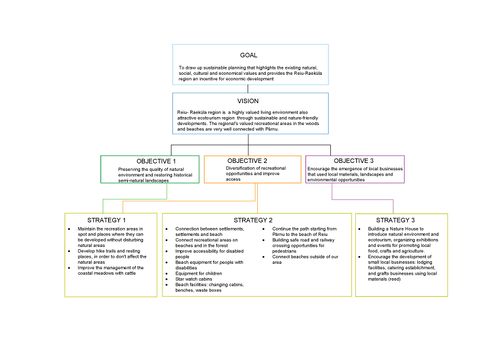
There are different protected areas in our area: coastal meadows belonging to the Natura 2000 network and forests landscape protection area. This is vital to know in order to develop a project. That it is why the preservation of the natural environment is our first goal. The project should be suitable taking into account the values and risk the natural area of Reiu- Raeküla. The improvement of the recreation area it is important too, in our previous task we found out that the existing recreation could be develop in order to provide better recreational opportunities for the people living in the area as well as for tourists. This lead us to out final goal which it is the economic development of the region through improvement of recreational services, in which we try to make the project to have a balance between the natural aspect, the social and economic. We try to make a suitable, sustainable, and resilient project as we are able to. | |||
Our goals are also in line with the sustainable development goals set out in the first phase: | |||
1. Health and well-being | |||
2. Decent work and economic growth | |||
3. Sustainable cities and communities | |||
4. Life on land | |||
== C.2 Spatial Strategy and Transect == | == C.2 Spatial Strategy and Transect == | ||
The location of the Reiu-Raeküla area near the big city makes it an attractive living environment, the proximity to the sea increases the pressure of real estate development even more. At the same time, the area has beaches and forests that offer recreational opportunities for everyone. Our vision is to improve access to recreational areas and diversify the number of users by developing the existing values of the region and to increase the attractiveness of the region for nature tourism lovers. Increasing the number of visitors promotes the development of local businesses. The following diagram shows how we plan to achieve our goals: | |||
<gallery caption=" " widths="500px" heights=" | <gallery caption=" " widths="500px" heights="500px" perrow="1"> | ||
File: | File:Reiu Raeküla Strategy Tree.jpg|''Strategy tree'' | ||
File: | File:Reiu Raeküla Masterplan.jpg|''Masterplan'' | ||
File: | File:Reiu Raeküla Transect A.JPG|''Transect A'' | ||
File: | File:Reiu Raeküla Transect B.JPG|''Transect B'' | ||
File:Reiu Raeküla Transect C.JPG|''Transect C'' | |||
File:Reiu Raeküla Forest Cabins.jpg|''Forest cabins'' | |||
File:Reiu Raeküla Nature House.jpg|''Nature house'' | |||
File:Reiu Raeküla Meadow Boardwalk.jpg|''Boardwalk over meadow'' | |||
File:Reiu Raeküla Sea Cabins.jpg|''Beach cabins/ stargazing cabins'' | |||
File:Reiu Raeküla Beach.jpg|''Beach'' | |||
</gallery> | </gallery> | ||
== C.3 From Theory of Change to Implementation == | == C.3 From Theory of Change to Implementation == | ||
<gallery caption=" " widths="500px" heights=" | The coastal landscape of Pärnu is rapidly changing and sensitive with a unique ecology. Coastal meadows, lagoons and beaches are often under the interest of human activity because of their location, natural beauty and abundant animal and plant species. However, rapid and unorganized development will rapidly ruin the ecosystem and decrease potential natural and social values for the settlements in the proximity. | ||
File: | It is therefore essential to evaluate 1. what kind of activities to allow into these areas, 2. whether and how to maintain the landscape, 3. how and where to allow to build, 4, were to have accesses to the area, 5. how to take care the water bodies and increase readiness for possible flooding. | ||
The current work was carried out in order to study the coastal landscape of Pärnu Reiu-Raeküla area, to evaluate the natural qualities, risks and potentials, and for developing a sustainable wellness plan for taking into account 1. human wellbeing, 2. economic wellbeing and 3. nature wellbeing. The phases of the work are pictured in the process flowchart. | |||
'''The legal framework''' | |||
In certain areas, there is a national legal requirement (phase 1) to keep and protect the environment from the negative impacts of human activity, based either for public health or for nature protection (Water Act, Nature Conservation Act, Forest Act). Estonia as an EU member (phase 1) has also international obligations by the European Union environmental policy, adjusted by national legislation, and monitored by the European Commission (Directive 2009/147/EC on the conservation). Marine Strategy Framework Directive (MSFD, 2008/56/EC) is beyond the scope of this work. As a member of the United Nations, Estonia is committed to Agenda 2030 (phase 1). From the seventeen goals in this work, the most important were numbers 4., 6., 8., 11., 15.,17. | |||
'''Adjustments to the local environment of Häädemeeste and Pärnu''' | |||
For the plan to be feasible, it also became essential to study the Pärnu County strategy and the economic structure of both Häädemeeste and Pärnu, as the study area belongs to both of them. The set cornerstones targeted to 2030 of strategy are 1. Smart Economy, 2. Tourism and recreation, 3. Human resources, 4. Ecotechnology (phase1). These were examined with the SWOT process, and each decisive factor and internal factors were taken into the brainstorming process, which as a result gave a narrative: Empowerment and Wellbeing with Coastal Acupuncture (phase 2) | |||
'''From narrative to service product''' | |||
The narrative (with visions and goals) was taken into a preliminary design phase (phase 2), after which it would go to the notifying. This phase 3 includes all the information processes with hearing and appealing processes of all the stakeholders. As the number of stakeholders is significant, there should be several options to have the information and possibilities to inform the concerns and worries. In phase 4, the plan would be corrected and completed. Phase 5 includes the approval process for the implementation. Phase 6 and 7 include starting of the implementation, grey infrastructures: protecting the existing nature during the construction work, roads, electricity, sewer and drain systems, service area and parking areas. In Phase 8., part of the area would be finished by having the boardwalks and access to the beach. Phase 9 would include the building of the Nature House, the core of the plan, in which there would be a visitor centre, education of sustainable material use (reed), exhibitions (nature photographs), shop for nature art, handicraft and a cafeteria serving local food. The Nature house would also serve as a base for meadow maintenance camps, and ecotourists and hikers. Phase 10 would include the restorative meadow work, building fences for the cattle, phase 11 would be the final opening of the whole area for the public. | |||
'''The outcome''' | |||
The plan would serve local economy by powering B2B, B2C services in Häädemeeste and Pärnu, increase NGO influence in coastal areas, increase home-based businesses and the traditional farming in coastal areas and ecological food production, increase recreational options of dwellers and tourist, increase education and public awareness of Estonian culture and nature and increase the wellness and health of the dwellers, visitors and nature. The planned and controlled process would optimize protecting nature, that is sensitive to change, and increase wellbeing in a balanced way. | |||
<gallery caption=" " widths="500px" heights="400px" perrow="1"> | |||
File:Reiu Raeküla Theory Of Change to Implementation.JPG|''Project flow chart'' | |||
</gallery> | </gallery> | ||
== C.4 References == | == C.4 References == | ||
* | * https://www.academia.edu/4606300/Coastal_lagoons_in_Estonia_and_in_the_Central_Baltic_Sea_region | ||
* https://www.academia.edu/2592728/Managing_meadows_or_managing_people_Coastal_meadow_restoration_and_management_in_the_Häädemeeste_region | |||
* https://www.light-for-the-world.org/un-2030-agenda-sustainable-development | |||
* https://www.envir.ee/sites/default/files/elfinder/article_files/paf_est.pdf | |||
* https://ec.europa.eu/environment/nature/natura2000/management/docs/FAQ-WFD%20final.pdf | |||
* https://www.oecd.org/environment/country-reviews/OECD_EPR_Estonia_Highlights.pdf | |||
* https://helda.helsinki.fi/bitstream/handle/10138/40630/FE485_08%2C_Inventories_for_nature_protection_in_Estonia_-_problems_and_results.pdf?sequence=8 | |||
* https://www.envir.ee/sites/default/files/paf_estonia_2020_2027.pdf | |||
* https://ec.europa.eu/environment/life/project/Projects/index.cfm?fuseaction=search.dspPage&n_proj_id=4076 | |||
* https://www.keskkonnaagentuur.ee/sites/default/files/elk2015_eng.pdf | |||
* https://webgate.ec.europa.eu/fpfis/cms/farnet2/on-the-ground/flag-factsheets/parnu-flag_en | |||
* https://life.envir.ee/urbancows | |||
* https://www.academia.edu/2091833/This_report_can_be_downloaded_from_www._balticgreenbelt._net | |||
Hagen, D., Kotiaho, J. S., Kareksela, S., Lindhagen, A., Isaksson, D., Päivinen, J., . . . Hansen, K. T. (2016). Restoration priorities and strategies : Restoration to protect biodiversity and enhance Green Infrastructure : Nordic examples of priorities and needs for strategic solutions. Nordic Council of Ministers. TemaNord, 2016:534. Retrieved from http://norden.diva-portal.org/smash/get/diva2:1033385/FULLTEXT01.pdf | |||
* Floods Directive: progress in assessing risks, while planning and implementation need to improve , EN 2018, 25 | |||
* Pärnumaa arengustrateegia 01.01.2019.pdf | |||
* Green Infrastructure in Estonia — Biodiversity Information system for Europe.pdf | |||
* Natura 2000and Urban planning.pdf | |||
* Strategic planning tree for a municipality 2017.pdf (EMÛ TEACHING MATERIAL) | |||
= D. Process Reflection = | = D. Process Reflection = | ||
Learning from spatial planning based on a case study was a good method. The alternation of thematic lectures with the practical part provided a lot of new knowledge, but it was also quite tense and fast. In the course of our work, we gained valuable knowledge from each stage of the planning process. In the course of the work, we explained the strengths of the group members and planned the division of work accordingly. Already in the analysis phase, we set priorities unanimously. After visiting the area during the landscape and coastal assessment, we ranked the challenges, risks, values and potentials. The planning of the area was complicated by the large proportion of protected natural areas, which significantly limited the possibilities of the solution we offer. In the course of our work we learned to take better account of the surrounding area and the connections of the planned area with it. There were no problems with the use of information sources, because there were 3 Estonians in the group and we also had the opportunity to visit the area. | |||
Latest revision as of 09:47, 9 April 2020
>>>back to working groups overview
| Area | Reiu-Raeküla | |
| Place | Pärnu county | |
| Country | Estonia | |
| Topics | Multifunctional coastline, meadows, forest, tourism | |
| Author(s) | Suvi Pohjola-Stenroos, Renata Villalobos Anaya, Karin Rea, Mirjam Manglus, Airi Loid, Massooma Abbas | |
|
| ||

Rationale
Raeküla & Reiu area is located south-east of Pärnu. The is important recreational area for the locals and also for the tourists. There are beautiful sandy beaches and a system of illuminated health paths built into the forest. At the same time coastal meadows and forests are protected areas for habitats and species. This may create a conflict between an increasing numbers of vacationers and the conservation objectives of the species. The purpose of future planning is to maintain a balance between those two aspects. The future planning must also take into account the increase of water levels what are caused by climate change.
Location and scope
You can edit this map with the map editor
A Landscape System Analysis
A.1 Landscape layers and their system context
Geomorphology, landscape units and coastal typology
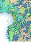
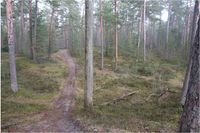
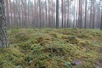
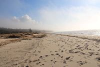
The Raeküla (Pärnu city)-Reiu (Häädemeeste county) study area is in south-western Estonia on the western coast of the Gulf of Riga. The 150-km-long coastline is straight. During the deglaciation of SW Estonia, the Baltic Ice Lake formed between the retreating Scandinavian Ice Sheet and emerged land in the southeast at about 13,300 cal, years BP. The Baltic Ice Lake water was deep enough for the formation of annually laminated varved clays over a vast area in Pärnu Bay and the present-day mainland area. Due to the shift in water levels interrupted by Ancylus Lake and Littorina Sea transgression, the landscape OF SW Estonia changed dramatically. The land uplift in relatively low in the Pärnu region and has always been at risk of flooding. The area is known for unique environmental settings: mild maritime climate, broad beaches, coniferous pine forests on the coastal zone. Types of Landscapes types include mixed and broadleaved forests, traditional agricultural semi-natural landscapes, wooded meadows, plant communities, heathland, bogs and moors, complex anthropogenic areas with different land use structure, shrubland, grasslands, birch-dominating coastal areas and flooded meadows
-
 Geology (Source: Maa-amet)
 -
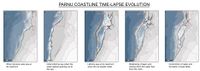 Coastline reconstruction of the eastern Gulf of Riga, Baltic Sea, during the Stone Age (Source: Wiley online Library)
 -
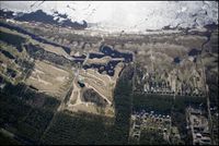 Areal view (Source:Maa-amet)


Land use
The land use presented in this region of Estonia it is wide. According to “Land Use map: Land Board 2020” in this area the main land uses are such as: Forest, grassland, green space, private yard and other.
The forest area has around 23.99% of the total area, the grassland 22.41%, green space 15.66%, private yard 19.62% and other 14.20 By this we could say that the land use has change by the time, but there are parts that have stayed mostly are the forest and the grassland area. There exist other kind of land use, and also represent an important part of the area such as: Bogs with 6.37%, fields 6.06%, Production yard with 2.26%, gardening land 1.24% and shrub with 2.82%.
The land use that have the least presence on the area are such as: Cemetery 0.17%, landfill 0.02%, port 0.04%, sandy area 0.58%, shallow bog 0.06% and wasteland with 0.06%.
The land use in the area has changed over time and there are several land use that were added according to several needs. Hopefully in the future the forest area will remain as well as the grassland. This could only happen of the urbanization of Pärnu remains and does not spreads.
-
 Land use map (Source:Geoportaal)
 -
 Land use diagram
 -
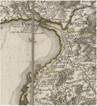 Land map from 1797 (Source:Old Maps Online)
 -
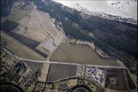 Areal photo of different land usages (Source: Maa-amet)


Green/blue infrastructure
1/3 of the area consists of a landscape reserve and forest growing on it. There are health trails that can be used all year round. Under protection are the bird species: Pernis apivorus, Bonasa bonasia, Strix uralensis, Caprimulgus europaeus and the plant species: Listeria ovata, Epipactis helleborine, Dactylorhiza incarnata, Huperzia selago. In the coastal meadows the reed has grown and the characteristic vegetation is disappearing. To restore it, an urban cow project has been launched: in summer, cows live on coastal meadows and eat less reed, and the former vegetation is restored.
Elements of blue infrastructure:
1) Pärnu bay
2) Reiu river, border of study area
3) Pärnu river
Forces of changing (Peoples treatment):
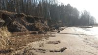
1) Real estate developments in coastal areas and near highways - which can lead to the disappearance of forests, as well as the conversion of protected forests to wind.
2) Increase in the number of holiday tourists on the beach – which may have negative impact on the cleanliness of the water and the shoreline
3) Increasing ATV and bicycle users; and uncontrolled use of forest paths – may endanger the conservation of protected species
4) The construction of the Rail Baltic railway - may adversely affect the landscape protection area in the central part of the study area. Completed railroads can also degrade residents' access to health trails in the forest
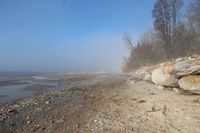
Coastal conditions can also change due to natural forces:
1) The high shoreline damages the high shore near Reiu village
2) Climate change may cause coastal meadows and buildings closer to the sea to be submerged
-
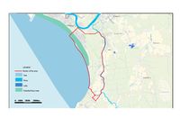 Reiu & Raeküla Blue infrastructure
 -
 Reiu & Raeküla Green infrastructure


Actors and stakeholders
Areal problem – possibilities
- Pärnu county population 86.163
- Pärnu city 43.000, Häädemeeste 4.800 > during the summer months > 100.000
- Ethnic groups: Estonians (79.3), Russian (15.3%), Ukrainians (2.12%), Finns (0.73%), Belarusians(0.65%) > heterogenicity
- Economically balanced region with many comprehensive industries
- Competitive business on worldscale markets in some sectors
- Active non- profit organizations especially in nature resources, (14 association /1000 inhabitants)
Local market
- Tourism
- Harbour (guest harbour: for 140 boat spaces with all facilities)
- Fishing
- Trading
- Wellness and holiday resort business
- Accomodation (b&b)
- Events: music festivals, sport events
- Historical scene: museums, historical sites, traditional
- Nature: bird watching, photographers
- Construction, developers, real estate
Problems
- Coastline nature sensitive for extensive tourism
- Water quality problems (nutrients, shallow bay, temperature, wind> favour cyanobacteria = toxic blue algae)
- Connections challenging; limited possibilities to walk from pärnu city to Lottemaa direction along the seafront
- Occasional flooding
- Occasional ridged ice formation causes damages on sea front
- Cyanobacteria on Pärnu beach
Potential
- Nature tourism in balanced way
- Coastline activities: bird watching, plant watching, butterfly watching,
- Serene walking paths in pine forests
- Star watching cabins on the beach
- Pärnu city sea pool with boardwalk
- Connected trail between sea pool, selected coastal meadows, to serene
- Piers for landscape and sea watching along the route
-
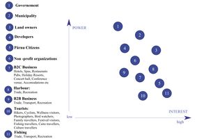 Reiu & Raeküla powermap

Sacred spaces and heritage
In the study area has been offically marked two elements that hold cultural value.
The first area has two memorials to terror victims in World War II. The statue was established in 1967 and tombstone was established in 1991 – after Estonian Restoration of Independence. The common tomb is in Raeküla forest.
The second element is historical schoolhouse. The school has had historically very important impact on education of Pärnu city. Raeküla school society was established in 1903 and at the same time was opened two grade school. The schoolhouse was finished in 1912. In 1919, the school housed the 7th Pärnu Elementary School.
Raeküla is a district of Pärnu city. The first mentionings of the ‘garden city’ is dated in 1265. Rapid growth of the village started in 1896. Narrow-gauge railway from Valga to Pärnu was built in 1896. The father of Konstantin Päts (the first president of Estonia) was well-known construction foreman who moved to the area and started to develop the village. Raeküla is full of single family houses with little gardens. The area has specific style that is kept throughout the district.
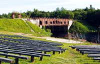
The railway from Valga to Pärnu has had great impact on the development of the study area. The Reiu bridge was established in 1927. It is a bridge for narrow-gauge railway. The railway is not in use. The bridge was unusable by the year 1944. Nowadays the railway bridge has a recreational use. There is an open-air stage next to the old railway bridge where Pärnu Endla Theater organizes open-air performances in the summer.
-
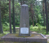 Monument/ memorial for terror victims in World War II (Photo:Tarvi Sits)
 -
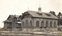 Raeküla historical schoolhouse (Source: Pärnu Raeküla kool)
 -
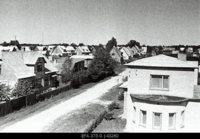 Raeküla distric 1967 (Source: Ajapaik)
 -
 Reiu old bridge (Photo:Heidi Tooming )


Visual appearance and landscape narrative
There is not any known visual or written creation about the areas. There can be some paintings that local small artist have done but their works are not usually public so they can’t be found and this statement can’t be totally confirmed.
If we take a modern turn then we can see that people have captured a moment/ activities the way that the nature is always big part of that. Different kind of activities and opportunities for different tastes. People are capturing elements that they like and feel good about.
-
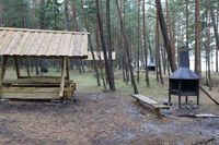 Picnic area (Photo: private collection)
 -
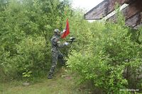 Active sport paintball (Photo: private collection)
 -
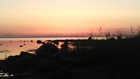 Opportunity to enjoy views (Photo: private collection)
 -
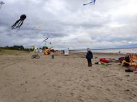 Estonian Kite Festival (Photo: private collection)


A.2 Summary of your landscape system analysis and your development targets
Human activities:
- Industry
- Service sector
- Logging
- Heating houses with wood
- Tourism &
- Hospitality Services
- Large outdoor events,
- Traffic-Transport
Nature processes:
- Strong wind
- Waves
- Erosion
- Sedimentation,
- High temperature changes
- Lack of ice on sea on winter
- Flooding
Pressure:
- CO2
- Soil & Water pollution
- Tree damages
- Noise &Light pollution
- Littering.
State:
- ATM the study site is more protected and in natural state
- Used for recreation, bird watching, picnicking, family holidays, nature watching, producing
wellbeing and joy, but does not have connection to city network along the seafront
- Tree roots on certain spots have remarkable erosion lesions
- Occasional urban sprawl along the seafront.
Impacts:
- If the development continues and the sea level rises more often or permanently, high wind,
waves and flooding will cause damage to ecosystems and as well as to residential areas.
- Coastal meadows will be under water, ditches do not drain, household water supplies
(surface water source) may contaminate from flooding surface waters
- Pollution will cause health problems, invasive species appear and start taking over the native
- Number of pollinator will decrease, soil will compact and trees have damages.
- Without proper zoning on coastal areas, disturbances will take over the entire Pärnu Bay.
Zoning requirements include separating the following areas: trade, fisheries and protected areas.
- Water pollution will decrease to value of Pärnu as a wellness resort and increase health hazards.


A.3 Theory reflection
We are all affected by the climate change, the clear evidence of this is rising sea levels in the and increased precipitation. Coastal areas are particularly vulnerable in this respect. „Guiding Principles for City Climate Action Planning“ speaks mainly about cities and the changes they need. Positive changes in cities also affect the surrounding areas with the same positive way. Recommendations apply to smaller municipalities for planning decisions. The study area is already experienced flooding problems and the strong wind and heavy waves are destroying the shore.
Natura 2000 is a European network of nature conservation areas and aims to maintain (where necessary) or restore the status of threatened species and habitats across Europe. The meaning and content of Natura 2000 are laid down in EU Directive 92 /43 (EMÜ). As the Raeküla coastal meadow is a part of the Natura 2000 network, it must be managed in accordance with the principles of ecology and sustainability, avoiding significant disturbance to the species. However, Natura sites can be important destinations for nature tourism and this has a positive impact to the local economy.
Multifunctional use of green infrastructure would to improve the quality of life in many Pärnu Bay area in many ways. It has environmental, social and economic credentials, based on the multifunctional use of natural capital. It’s a potentially a very valuable policy tool, GI’s multifunctionality could contribute to the achievement of a number of policy aims and fulfil the needs of a variety of stakeholder groups.
The Häädemeeste municipality development plan sets out visions until 2030. The purpose of the municipality is to provide for the local population a pleasant living environment with workplaces, but also to become more attractive to the visitor, especially families. There may be a conflict between the development of tourism in the area under study and the preservation of the natural environment, because conservation status requires reduced human intervention and some activities are undesirable or even prohibited during certain seasons.
A.4 References
https://www.stat.ee/news-release-2020-016
https://news.err.ee/977849/swimming-still-not-advised-in-parnu-after-cyanobacteria-found-in-seawater
http://www.parnusadam.ee/en/info
http://www.fishingvillage.ee/en/
https://en.wikipedia.org/wiki/Pärnu
https://register.muinas.ee/public.php?menuID=monument&action=view&id=8341
https://register.muinas.ee/public.php?menuID=monument&action=view&id=27187
https://www.raekyla.parnu.ee/et/koolist/ajalugu
https://tarbija24.postimees.ee/1367348/raekula-ehk-patsikula-ehk-rotikula
https://ajapaik.ee/photo/182845/raekula-linnaosa-parnus/
http://www.raudtee.eu/?main=1&sub=51&stat=146&tlink=0
http://entsyklopeedia.ee/meedia/reiu_j%C3%B5gi3/paikuse_reiu_joe_vabaohulava
https://infoleht.keskkonnainfo.ee/GetFile.aspx?fail=639343088
https://www.raekylavanakool.ee/wp-content/uploads/Jäljed-Raeküla-linnaosas.pdf
https://www.researchgate.net/publication/318199123_The_Baltic_Sea_Basin
https://papers.ssrn.com/sol3/papers.cfm?abstract_id=3506436
https://onlinelibrary.wiley.com/doi/full/10.1111/bor.12157
https://xgis.maaamet.ee/xgis2/page/app/geoloogia400k
https://fotoladu.maaamet.ee/?basemap=hybriidk&zlevel=8,24.53354,58.29405&overlay=avaleht
https://www.khanacademy.org/test-prep/mcat/society-and-culture/demographics/a/what-is-urban-growth
https://www.oldmapsonline.org/
https://ajapaik.ee/map/?mapType=roadmap&lat=59&lng=26&zoom=8&photoModalOpen=1&limitToAlbum=1
http://1886.u-bordeaux-montaigne.fr/items/show/70160
https://www.oldmapsonline.org/map/u-bordeaux-montaigne/70160
https://ajapaik.ee/map/?mapType=roadmap&lat=59&lng=26&zoom=8&photoModalOpen=1&limitToAlbum=1
Phase B: Landscape Evaluation and Assessment
B.1 Assessment Strategy
As in Phase A, the highest proportion of natural components found in the region are beaches, forests, agricultural land. The forest covering 1/3 of the area is a landscape reserve, coastal meadows are part of the Europe wide Natura 2000 network. Housing construction has developed in a peaceful manner in the area, but industrial activity is not very important. The Reiu-Raeküla area is located in the immediate vicinity of the larger city of Pärnu and its natural environment is an important recreation area for the inhabitants of Pärnu. However, the area's recreational function could be developed, but protected natural environments require a more sensitive approach. It is also important to consider the profile and the recommended number of visitors.
Our priorities:
1. Preservation of the natural environment
2. Increasing vacation opportunities and making them more accessible
3. Economic development of the region through the improvement of recreational services.
It is important to assess the sensitivity of the landscapes for further work on the priority axes, so we present the following maps:
1. Connections and settlements that assess the availability of recreational facilities for the local population and for those who come further
2. Map for basic users of vacation facilities
3. Map of the region's natural, social and economic values.
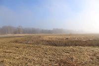
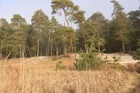
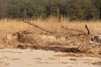
Overview of the area
-
 Landscape protection area (Photo: private collection)
 -
 Landscape protection area (Photo: private collection)
 -
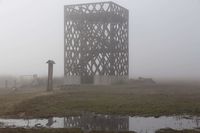 Meadow bird watching tower (Photo: private collection)
 -
 Meadow (Photo: private collection)
 -
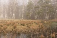 Meadow (Photo: private collection)
 -
 Rae beach (Photo: private collection)
 -
 Rae beach (Photo: private collection)
 -
 Rae beach (Photo: private collection)
 -
 Reiu beach (Photo: private collection)
 -
 Reiu beach (Photo: private collection)


B.2 Mapping
1. Connections and settlement
2. Service users and activities
3. Values
3.1 Social values
3.2 Nature values
1. Settlement and connections
-
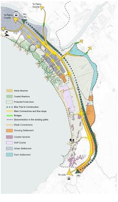 The biggest settlement in the study area it is Raeküla. The other settlement we can find in the study area are the Urban Sprawls. These ones are located besides the coastline. The typology are housing villas mainly. It is a suggestion that these settlements, should be moved. Because of their closeness to the coastline in a future, there is an imminent risk of flood. Another type of settlement we find it is a growing settlement. Located in Silla, this settlement has all chances to be a dense settlement for a future.The public transport connections are great. There is some seasonality in the public transport availability - the connections are better in summer time. The average distance from Bus stop to recreational area is 2.5 km or less. The connections for bicycles is in development what will be about 16 km. There are some bike trails around Paikuse open-air stage. The weakest connections are around the coastal line. The coastal area has big potential to have one long promenade from Pärnu to Lottemaa theme park. The promenade is the missing link to good connections in the coastal area. In the future this region is cut half by Rail Baltica. The coastal line is most attractive recreational area in the region. The railway will have negative impact on flora,fauna and connectivity. The green infrastructure and natural spreading of plant species will be disturbed.

2. Recreation
-
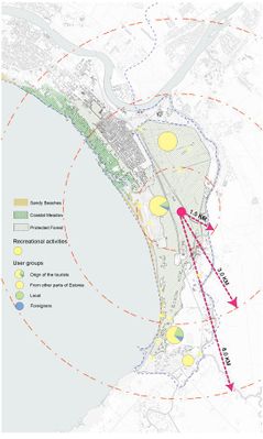 The average distance of residential buildings from the nearest recreational area is 2.5 km.Most of the tourist who visit the area are from Estonia. Most of the activities are located at the coastal line or in the forest. The area has beautiful nature that people wish to see and take a break from everyday life.

3. Values
3.1 Social values
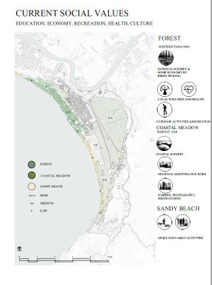
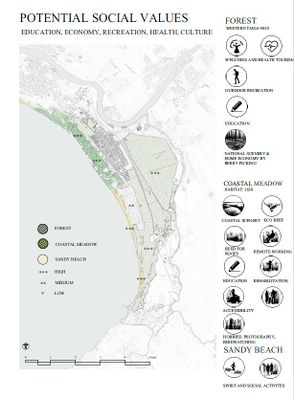
1. Green environment: habitats: forest, coastal meadow and sandy beaches.
2. Blue environment: the interface of sea and land, usage, accessibility and along the seafront.
3.Grey environment: settlements, connections and accesses. The nature and social values of the current situation were prescribed.
Social values: Grey environment: several types of settlements, both more dense/urban, but also rural/scattered pattern, accent villas near coastline. The access to the seafront limited already. Flooding may become a threat in the future. Green environment: – Forest: medium scale outdoor activities, recreation, local wellness and health. Meadow: seasonal maintenance work, bird watching. Sandy beaches: Family activities. Public health threats depending the water quality.
Summarized: potential resource, protection need special management and approaches, access to seafront is a limited resource, improper use/management may destroy biodiversities
-
 Current social value.
 -
 Potentsial social values


3.2 Nature values
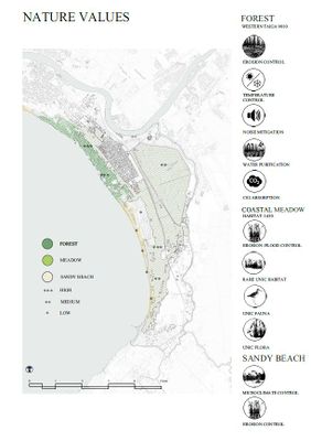
This map shows the values of the various landscapes in the study area. The area is characterized by a high percentage of natural areas, their value being primarily biodiversity and the provision of various recreational opportunities. Natural areas are valued at high, medium and low. Coastal meadows are of the highest value as many different bird species breed and stop there, as well as rare species of plants, such as wild orchids. The forest area is of medium value because the vegetation is a little poorer in species, but the fauna and birds are rich in species. The natural value of the golf course is estimated to be low because of its intensive maintenance and very low species diversity. Agricultural areas have the lowest value and have the lowest species diversity. Natural opportunities are not well used to generate economic income. The potential of nature could be better utilized in providing recreational activities by diversifying them. The area is used for recreational purposes such as sunbathing and hiking. Coastal meadows and forests are also protected, which also helps to preserve existing values better.
-
 Nature values

B.3 Problem definition and priority setting
-
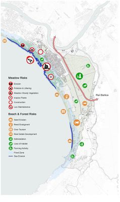 Risks- The main risks for meadows are erosion, pollution and littering, forestation of meadows, invasive plants, construction and overall low maintenance. These risk factors are mainly located in the North-West of the study area. Biggest risks are low maintenance and from low maintenance comes the forestation of the area.The main risks for beach area are sand erosion, reed enlargement, over tourism, real estate development, sea erosion and flooding. Over tourism is considered as a risk only at the beach region.The main risks for forest zone are deforestation, loss of habitat, farming activities, real estate development. The biggest risk is deforestation because it will influence other factors like habitat. Also, Rail Baltica will have major negative impact to the forested area.
 -
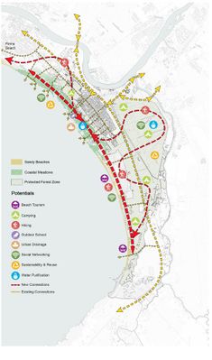 Potentials- Coastal area potentials are beach tourism, social networking, hiking, water purification, urban drainage and sustainability. The biggest potential is to make new connections to link the forest area to coastal zone. For forest the potentials are mainly camping and hiking.The priority is to protect the nature and improve connections between forest and beach. This link will help to develop the area from the socioeconomic point


B.4 Theory reflection
Our study area is located in an area of rich nature, including forests, coastal meadows, sandy beaches, as well as agricultural land and residential areas. So we used the Landscape Character Assessment, which aims to identify landscapes that are sensitive in nature and highly valued for their nature and characteristics. (LCA) This allows us to decide what changes can be made without significant changes in the landscape. We used Coastal Character Assessment to assess the coastline, which, like the previous one, helps identify sensitive coastal landscapes. For a more accurate result, it was also possible to conduct an on-site field survey, which allowed us to identify details not visible in the map analysis in phase A. Similar to the SWOT analysis method, we determined the values, risks and opportunities of different landscape types. Mapping them gives us directions for the next strategic plan. The most sensitive landscape type was the coastal meadow of our area, which is important not only at local level but also at global level through natural processes (TEEB)
B.5 References
- Maa-amet geoportaal
- http://pol.parnumaa.ee/content/editor/files/Pärnu%20TP_Transpordiuuring_20101117.pdf
- Hagen, D., Kotiaho, J. S., Kareksela, S., Lindhagen, A., Isaksson, D., Päivinen., J.Hansen, K. T. (2016). Restoration priorities and strategies : Restoration to protect biodiversity and enhance Green Infrastructure : Nordic examples of priorities and needs for strategic solutions. Nordic Council of Ministers. TemaNord, 2016:534. Retrieved from http://norden.diva-portal.org/smash/get/diva2:1033385/FULLTEXT01.pdf
- TEEB: Economics of Ecosystem and Biodiversity. The Economics of Ecosystem and Biodiversity. http://www.teebweb.org/
- Scottish Natural Heritage: nature.scot. Landscape Character Assessment, https://www.nature.scot/professional-advice/landscape/landscape-tools-and-techniques/landscape-evaluation
Phase C – Strategy and Master Plan
C.1 Goal Setting
- Define strategic planning objectives based on the evaluation findings
- Link back to your original targets from section one and the Development Goals
There are different protected areas in our area: coastal meadows belonging to the Natura 2000 network and forests landscape protection area. This is vital to know in order to develop a project. That it is why the preservation of the natural environment is our first goal. The project should be suitable taking into account the values and risk the natural area of Reiu- Raeküla. The improvement of the recreation area it is important too, in our previous task we found out that the existing recreation could be develop in order to provide better recreational opportunities for the people living in the area as well as for tourists. This lead us to out final goal which it is the economic development of the region through improvement of recreational services, in which we try to make the project to have a balance between the natural aspect, the social and economic. We try to make a suitable, sustainable, and resilient project as we are able to.
Our goals are also in line with the sustainable development goals set out in the first phase:
1. Health and well-being
2. Decent work and economic growth
3. Sustainable cities and communities
4. Life on land
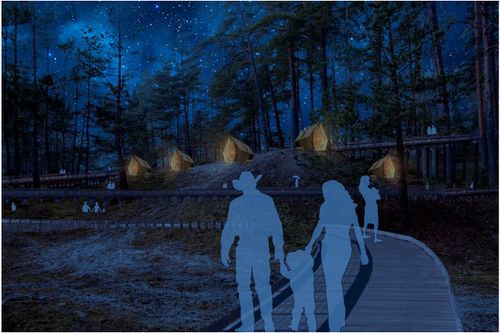
C.2 Spatial Strategy and Transect
The location of the Reiu-Raeküla area near the big city makes it an attractive living environment, the proximity to the sea increases the pressure of real estate development even more. At the same time, the area has beaches and forests that offer recreational opportunities for everyone. Our vision is to improve access to recreational areas and diversify the number of users by developing the existing values of the region and to increase the attractiveness of the region for nature tourism lovers. Increasing the number of visitors promotes the development of local businesses. The following diagram shows how we plan to achieve our goals:
-
 Strategy tree
 -
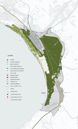 Masterplan
 -
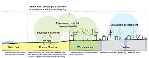 Transect A
 -
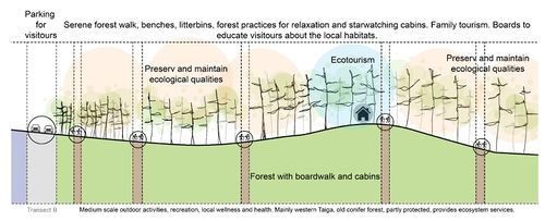 Transect B
 -
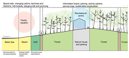 Transect C
 -
 Forest cabins
 -
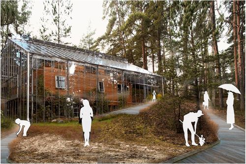 Nature house
 -
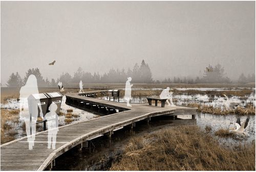 Boardwalk over meadow
 -
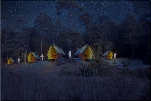 Beach cabins/ stargazing cabins
 -
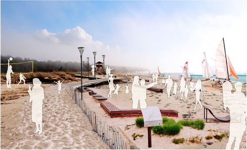 Beach
Beach


C.3 From Theory of Change to Implementation
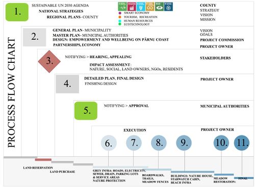
The coastal landscape of Pärnu is rapidly changing and sensitive with a unique ecology. Coastal meadows, lagoons and beaches are often under the interest of human activity because of their location, natural beauty and abundant animal and plant species. However, rapid and unorganized development will rapidly ruin the ecosystem and decrease potential natural and social values for the settlements in the proximity. It is therefore essential to evaluate 1. what kind of activities to allow into these areas, 2. whether and how to maintain the landscape, 3. how and where to allow to build, 4, were to have accesses to the area, 5. how to take care the water bodies and increase readiness for possible flooding. The current work was carried out in order to study the coastal landscape of Pärnu Reiu-Raeküla area, to evaluate the natural qualities, risks and potentials, and for developing a sustainable wellness plan for taking into account 1. human wellbeing, 2. economic wellbeing and 3. nature wellbeing. The phases of the work are pictured in the process flowchart.
The legal framework
In certain areas, there is a national legal requirement (phase 1) to keep and protect the environment from the negative impacts of human activity, based either for public health or for nature protection (Water Act, Nature Conservation Act, Forest Act). Estonia as an EU member (phase 1) has also international obligations by the European Union environmental policy, adjusted by national legislation, and monitored by the European Commission (Directive 2009/147/EC on the conservation). Marine Strategy Framework Directive (MSFD, 2008/56/EC) is beyond the scope of this work. As a member of the United Nations, Estonia is committed to Agenda 2030 (phase 1). From the seventeen goals in this work, the most important were numbers 4., 6., 8., 11., 15.,17.
Adjustments to the local environment of Häädemeeste and Pärnu
For the plan to be feasible, it also became essential to study the Pärnu County strategy and the economic structure of both Häädemeeste and Pärnu, as the study area belongs to both of them. The set cornerstones targeted to 2030 of strategy are 1. Smart Economy, 2. Tourism and recreation, 3. Human resources, 4. Ecotechnology (phase1). These were examined with the SWOT process, and each decisive factor and internal factors were taken into the brainstorming process, which as a result gave a narrative: Empowerment and Wellbeing with Coastal Acupuncture (phase 2)
From narrative to service product
The narrative (with visions and goals) was taken into a preliminary design phase (phase 2), after which it would go to the notifying. This phase 3 includes all the information processes with hearing and appealing processes of all the stakeholders. As the number of stakeholders is significant, there should be several options to have the information and possibilities to inform the concerns and worries. In phase 4, the plan would be corrected and completed. Phase 5 includes the approval process for the implementation. Phase 6 and 7 include starting of the implementation, grey infrastructures: protecting the existing nature during the construction work, roads, electricity, sewer and drain systems, service area and parking areas. In Phase 8., part of the area would be finished by having the boardwalks and access to the beach. Phase 9 would include the building of the Nature House, the core of the plan, in which there would be a visitor centre, education of sustainable material use (reed), exhibitions (nature photographs), shop for nature art, handicraft and a cafeteria serving local food. The Nature house would also serve as a base for meadow maintenance camps, and ecotourists and hikers. Phase 10 would include the restorative meadow work, building fences for the cattle, phase 11 would be the final opening of the whole area for the public.
The outcome
The plan would serve local economy by powering B2B, B2C services in Häädemeeste and Pärnu, increase NGO influence in coastal areas, increase home-based businesses and the traditional farming in coastal areas and ecological food production, increase recreational options of dwellers and tourist, increase education and public awareness of Estonian culture and nature and increase the wellness and health of the dwellers, visitors and nature. The planned and controlled process would optimize protecting nature, that is sensitive to change, and increase wellbeing in a balanced way.
-
 Project flow chart

C.4 References
Hagen, D., Kotiaho, J. S., Kareksela, S., Lindhagen, A., Isaksson, D., Päivinen, J., . . . Hansen, K. T. (2016). Restoration priorities and strategies : Restoration to protect biodiversity and enhance Green Infrastructure : Nordic examples of priorities and needs for strategic solutions. Nordic Council of Ministers. TemaNord, 2016:534. Retrieved from http://norden.diva-portal.org/smash/get/diva2:1033385/FULLTEXT01.pdf
- Floods Directive: progress in assessing risks, while planning and implementation need to improve , EN 2018, 25
- Pärnumaa arengustrateegia 01.01.2019.pdf
- Green Infrastructure in Estonia — Biodiversity Information system for Europe.pdf
- Natura 2000and Urban planning.pdf
- Strategic planning tree for a municipality 2017.pdf (EMÛ TEACHING MATERIAL)
D. Process Reflection
Learning from spatial planning based on a case study was a good method. The alternation of thematic lectures with the practical part provided a lot of new knowledge, but it was also quite tense and fast. In the course of our work, we gained valuable knowledge from each stage of the planning process. In the course of the work, we explained the strengths of the group members and planned the division of work accordingly. Already in the analysis phase, we set priorities unanimously. After visiting the area during the landscape and coastal assessment, we ranked the challenges, risks, values and potentials. The planning of the area was complicated by the large proportion of protected natural areas, which significantly limited the possibilities of the solution we offer. In the course of our work we learned to take better account of the surrounding area and the connections of the planned area with it. There were no problems with the use of information sources, because there were 3 Estonians in the group and we also had the opportunity to visit the area.