COLAND Case Study 2020 - Dunkerque (East): Difference between revisions
| (80 intermediate revisions by 4 users not shown) | |||
| Line 17: | Line 17: | ||
| '''Topics''' || style="background:Lavender"|''Environmental Heritage - Tourism and Commerce - Land Consumption'' | | '''Topics''' || style="background:Lavender"|''Environmental Heritage - Tourism and Commerce - Land Consumption'' | ||
|- | |- | ||
| '''Author(s)''' || style="background:Lavender"|''Ambrosino Mara | | '''Author(s)''' || style="background:Lavender"|''Ambrosino Mara, Hassler Alessandra, Savelli Giulia, Scoppola Pietro, Guerra Antonio'' | ||
|- | |- | ||
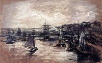
| colspan="3" align="center" style="background:silver"| [[File: | | colspan="3" align="center" style="background:silver"| [[File:30904532827 4fc9c5778d b.jpg|400px]] | ||
|- | |- | ||
| ||style="background:Lavender"| | | ||style="background:Lavender"| | ||
| Line 40: | Line 40: | ||
== A.1 Landscape layers and their system context == | == A.1 Landscape layers and their system context == | ||
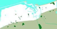
=== Geomorphology, landscape units and coastal typology === | === Geomorphology, landscape units and coastal typology === | ||
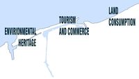
First of all in our area ,Dunquerke east, we identified the 3 keywords,as we can see, that return our image of thearea for us. | |||
The first, ENVIRONMENTAL HERITAGE, highlights the strong presence of the natural historical heritage of the area which leads us to identify the second keyword: | |||
TOURISM AND COMMERCE. Dunquerke area attracts a large tourist flow for its coast which performs a dual function, economic and environmental. | |||
However, these two functions clashed with each other and the economic function prevailed over the environmental one. For these reasons the urbanized part subtracts soil from natural part; hence the choice of the third keyword is : LAND CONSUMPTION. | |||
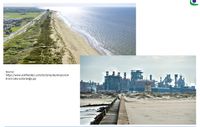
The characteristic elements of the coast are the sand dunes, are result of the natural effects produced by the wind and waves. The dunes outline the course of the soil which is slightly steep towards the sea. Moreover, these natural barriers mark the border between nature and urbanized environment, marked by docks. | |||
The docks are the center of the anthropized system formed by the port and industries, tourist and economic centers. | |||
These functions are in contrast with the surrounding naturalistic system but together they characterize the coast line of the area. | |||
<gallery caption=" " widths="200px" heights="150px" perrow="5"> | <gallery caption=" " widths="200px" heights="150px" perrow="5"> | ||
File: | File:Slide 1 Giulia.jpg|''Key words'' | ||
File: | File:Slide 2 Giulia.JPG|''Costal Typology'' | ||
</gallery> | </gallery> | ||
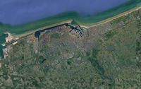
=== Land use === | === Land use === | ||
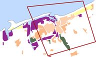
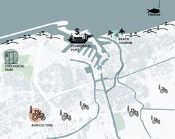
Dunkirk is characterized by three main functional areas: on the west side of our area, as we can see, there is an intensified presence of industrial activities because the port is the economic core of the area, the residential area is developed in the south area where there is a strong presence of historic buildings. | |||
Therefore on the east side there is a residential area characterized by a resort because it is not industrialized and still in direct contact with the coast line. | |||
All these functions, however, are not well connected to each other so in the future we assume that the predominant land use will be the infrastructure system. | |||
<gallery caption=" " widths="200px" heights="150px" perrow="5"> | <gallery caption=" " widths="200px" heights="150px" perrow="5"> | ||
File: | File:Costutio.jpg|''actual land use of the area'' | ||
File: | File:Costruito.jpg|''actual top view of the area from google maps'' | ||
File: | File:Legenda1.JPG|''legend'' | ||
</gallery> | </gallery> | ||
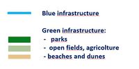
=== Green/blue infrastructure === | === Green/blue infrastructure === | ||
The main green and blue infrastructure is the coast line. This is characterized, as previously mentioned, from the dunes and the largest run east of the Belgian coast. The "dunes flamandes" (Flemish dunes) run to the east on the Belgian border. It is an absolutely unique ecosystem that hosts hundreds of botanical species. | |||
The beach is extended continuously over 15 km. Discovered at low tide, the vast zone is sometimes bordered by dunes. | |||
The blue infrastructures are characterized by the presence of water channels that run into hinterland and by the port that divides the anthropic system from the naturalistic one. Green infrastructures are characterized by a large presence of green soil which differs from agricultural and woodland soil. | |||
The connection between the green of the agricultural soils and the blue of the sea is interrupted by the presence of urbanized soil. | |||
<gallery caption=" " widths="200px" heights="150px" perrow="5"> | <gallery caption=" " widths="200px" heights="150px" perrow="5"> | ||
File: | File:V b.jpg|''green and blue infrastructures'' | ||
File: | File:V bg.JPG|''actual top view of the area from google maps'' | ||
File:Legenda verde.JPG|''legend'' | |||
</gallery> | </gallery> | ||
=== Actors and stakeholders === | === Actors and stakeholders === | ||
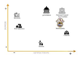
In Dunkerque the primary type of stakeholders is organizations and governmental associations in the area. The district is under the supervision of the municipality of Dunkerque which is one of the main stakeholders with a high level of interest and the influence. Therefore, the French National council for coastline is the highest-ranked interest organization in the area that is caring for landscape and it is responsible of the environmental issues of the area. | |||
The council is nominee by the national government every 4 years. | |||
Port industries also have a considerable influence as they strongly affect the economy of the area. | |||
Local people, tourists, investors, and businessman are considering as the second type of stakeholders. | |||
Each of them has a different role in the local society as they influence both social environmental and economic factors of the area. | |||
They can lead by the first group of the stakeholders to improve and promote the development factors of the area of Dunkerque. | |||
<gallery caption=" " widths="500px" heights="200px" perrow="5"> | <gallery caption=" " widths="500px" heights="200px" perrow="5"> | ||
File: | File:Power map Dunkerque East.JPG| ''Main Actors and Stakeholders in Dunkerque East'' | ||
</gallery> | </gallery> | ||
| Line 99: | Line 116: | ||
<gallery caption=" " widths="200px" heights="150px" perrow="5"> | <gallery caption=" " widths="200px" heights="150px" perrow="5"> | ||
File:9-plan-aquarelle 01.gif|''Dunkerque watercolor plan in 646'' | File:9-plan-aquarelle 01.gif|''Dunkerque watercolor plan in 646 _ Click to see the map!'' | ||
File:15-plan.gif|''Map of Dunkerque in 1400'' | File:15-plan.gif|''Map of Dunkerque in 1400 _ Click to see the map!'' | ||
File:23-Plan-arsenal.gif|''The naval park arsenal at the end of the 18th century'' | File:23-Plan-arsenal.gif|''The naval park arsenal at the end of the 18th century _ Click to see the map!'' | ||
File:ManifestoWIKI.jpg|''Artwork of Dunkerque heritage'' | File:ManifestoWIKI.jpg|''Artwork of Dunkerque heritage'' | ||
</gallery> | </gallery> | ||
| Line 124: | Line 141: | ||
File:Cantata.png|''“Cantate à Jean Bart”'' | File:Cantata.png|''“Cantate à Jean Bart”'' | ||
File:Jean-Baptiste-Corot-A-Dune-at-Dunkirk.jpg|''A dune in Dunkerque, Jean Baptiste Camille Corot'' | File:Jean-Baptiste-Corot-A-Dune-at-Dunkirk.jpg|''A dune in Dunkerque, Jean Baptiste Camille Corot'' | ||
File: | File:Large 000000.jpg|''The withdrawal from Dunkirk, Charles Ernest Cundall (1940)'' | ||
File: | File:2016 PAR 13572 0037 000(paul signac dunkerque).jpg|''Dunkerque, Paul Signac'' | ||
File: | File:Alexis Vollon.jpg|''The harbour of Dunkerque, Alexis Vollon'' | ||
</gallery> | </gallery> | ||
== A.2 Summary of your landscape system analysis and your development targets == | == A.2 Summary of your landscape system analysis and your development targets == | ||
''After our analysis we can explain the weakness and the strongness of Dunkerque by the DPSIR analysis model. | |||
Surely our Driving Forces are the cultural points like Museum Dunkerque, Lieù d’Art et Action Contemporane de Dunkerque, FRAC and the two ship Duchesse Anne and Sandettiè. Another strenght is the turist beach like Malo les Bains. | |||
About the Pressure, instead, one of the weakness is the impact given by the industries and the urban contest fragmentation. The States of the Green and Blu infrastructure are interrupted by the urban contest. A great value to improve the urban contest is given by the municipality that institueted the “Free Public Transport” which caused the economic growth and a less impact on the Climate change. | |||
By this way the municipality try to Response to the problems that we have shown before.'' | |||
<gallery caption=" " widths="500px" heights="200px" perrow="5"> | <gallery caption=" " widths="500px" heights="200px" perrow="5"> | ||
| Line 143: | Line 158: | ||
<gallery caption=" " widths="500px" heights="200px" perrow="5"> | <gallery caption=" " widths="500px" heights="200px" perrow="5"> | ||
File: | File:Hypothesis slide page-0001.jpg|''State of facts If the actual driving forces would continue as they do'' | ||
</gallery> | </gallery> | ||
| Line 157: | Line 172: | ||
= Phase B: Landscape Evaluation and Assessment = | = Phase B: Landscape Evaluation and Assessment = | ||
== B.1 Assessment Strategy == | == B.1 Assessment Strategy == | ||
*'' | *''In the face of the analysis that we made on the area we found that we could operate at best on the zone by powering biodiversity, landuse and accessibility. This analysis has been confirmed by a survey addressed to Danquerke citizien which validate that we have been able to identify the focal points to ensure a densest and closer process of development and protection of the territory.'' | ||
== B.2 Mapping == | == B.2 Mapping == | ||
| Line 166: | Line 179: | ||
<gallery caption=" " widths="500px" heights="200px" perrow="1"> | <gallery caption=" " widths="500px" heights="200px" perrow="1"> | ||
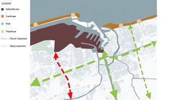
File: | File:Connections.jpg|''Two important themes emerge on this map. There are horizontal and vertical connections that connect Hinteland and the sea. Just a single axis does not reach the sea because it is closed by the barrier formed by the industrial area. A proposed project could be to connect the western part of the Dunkirk canal with the eastern part to bring it closer to the waterfront.'' | ||
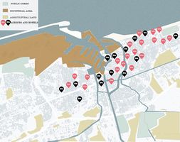
File: | File:Land use b2.jpg|''This map represents land use in terms of inhabited buildings, accommodation facilities, industries, agriculture and public green as they appear today. We observed these data on the basis of our previous analyzes and the questionnaire we submitted to the population of the area. The main urban changes date back to the second post-war period till 70s, however an increase in urbanized land in the coastal area can be noted in the last twenty years with a consequent increase in accommodation facilities, especially airbnbs (shown on the map with the red icon).'' | ||
File: | File:Ecosysterm service dune.jpg|''From the mapping of ecosystem services and from the study on the biodiversity of the territory, it emerged that our study area, by its nature, offers many benefits. In particular, the coast has a great biodiversity with the presence of tree species on its dunes and the fauna of its waters. In the hinterland there are various protected green areas where the typical fauna of the area is safeguarded but unfortunately, there is a great economic tendency to exploit the coast through the port which makes polluted waters at the expense of the species that live there.'' | ||
</gallery> | </gallery> | ||
== B.3 Problem definition and priority setting == | == B.3 Problem definition and priority setting == | ||
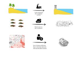
<gallery caption=" " widths=" | By mapping the three major aspects we chose to focus on ('''ACCESSIBILITY''', '''LAND USE''', '''BIODIVERSITY'''), what we were able to deduce was that: | ||
File: | |||
- There are different connections from the waterfront to the inner city and back at the moment, which might be a good starting point to work on to, in order to reclose the split which there is now between the coastline and the interland, due to the uncontrolled urbanisation of some activities. | |||
- In fact, the predominance of the industrial areas and the big port, in addition to the tourist urbanisation, are causing a deep cut in the landscape, making the coast not so easy to access. | |||
- Moreover, the industrial and harbour activity, got the pollution increasing over the years, having the local population to fear for the safety of the typical beach dunes which characterize the landscape. | |||
For each of these aspects, we deduced, then, the risks and the potentials, as two pieces of a coin. | |||
In fact, as it’s important to be aware of the dangers of the uncontrolled expansion of the industrial and harbour activities and of the tourist urbanization, so it is necessary to consider their role in the economy growth of the city and their potential in terms of agriculture and cultural heritage. | |||
As well as the density of buildings in the center, which make it hard to get access to the coast today, it’s still well connected so it could be easily improved with the development of the existing infrastructures turned to green. | |||
And in last, the biodiversity of the coast, whose risk is represented by pollution and climate change, has of course a great potential for its own nature. | |||
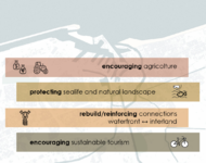
After mapping this system of pros and cons, we could set the '''goals''' for assessing the landscape. Those are: | |||
- Encouraging the '''agriculture''' and the '''local activities''', in order to try to balance the predominance of industry | |||
- Protecting the '''sealife and the biodiversity''' of the landscape from water pollution caused by harbour and industries and studying possible measures of '''sea level rise''' '''prevention''' | |||
- Finding a sustainable way of '''controlling urban development''', and reinforcing the '''existing connections''' to the waterfront with green infrastructures | |||
- Finding possible solutions for '''sustainable tourism''' | |||
<gallery caption=" " widths="200px" heights="150px" perrow="5"> | |||
File:Immagine2.png|''Assessment synthesis'' | |||
File:Immagine3.png|''Evaluation of Risks and Potentials'' | |||
File:Immagine1.jpg|''Risks and Potentials map'' | |||
File:Immagine4.png|''Priorities and targets'' | |||
</gallery> | </gallery> | ||
== B.4 Theory reflection == | == B.4 Theory reflection == | ||
The main difficulty we found during the second phase of the project was to set goals without having the possibility to study the area personally, so we tried to obtain updated datas about the environment and the perceptions of locals by writing a survey. | |||
https://docs.google.com/forms/d/e/1FAIpQLSf8qSJFpWRmuwB3UzMz0dC8Uo59d7tX_NnzY_K4_CfcRHEmfg/viewform?usp=sf_link | |||
From this we could obtain interesting answers about the risks and potentials as felt by the population: most of the answers, in fact, were from people who have been living in Dunkerque since their birth. | |||
We asked them about the importance of agriculture and the impact of harbour industry on the landscape and on the environment, getting very interesting answers, feeling the affection of locals for their city and their worry of losing the biodiversity due to pollution. | |||
It also helped us evaluating their ideas about the safeguard of the landscape, the prevention of risks and the elements of potentials which were essential in setting the goals for the project. | |||
<gallery caption=" " widths="200px" heights="150px" perrow="5"> | |||
File:Q1.jpg| | |||
File:Q2.jpg| | |||
File:Q3.jpg| | |||
File:Q4.jpg| | |||
</gallery> | |||
== B.5 References == | == B.5 References == | ||
| Line 190: | Line 245: | ||
=Phase C – Strategy and Master Plan = | =Phase C – Strategy and Master Plan = | ||
== C.1 Goal Setting == | == C.1 Goal Setting == | ||
Stepping back to the points we set previously [[https://colandwiki.hfwu.de/index.php?title=COLAND_Case_Study_2020_-_Dunkerque_(East)#B.3_Problem_definition_and_priority_setting| previously ]], | |||
the goals we aimed to define in our project could be reflected as some of the points of '''SDGs (Agenda 2030)''' like as: | |||
'''11. SUSTAINABLE CITIES AND COMMUNITIES ''' Supported by our will to set strategies to: | |||
- ''Promote sustainable tourism'' (Organic agriculture / 0 km origin; Technologies for water saving; Ecologically oriented renovation of hotel facilities for the choice of renewable energy sources; Mobility and Public Transport; Promotion and Knowledge of monuments and areas of historical; artistic and natural interest; Highlighting territorial cultural heritage) | |||
- ''Reinforcement of connections to the waterfront'' (green infrastructures); | |||
'''12. RESPONSIBLE CONSUMPTION AND PRODUCTION''' with the ''encouragement of agriculture'' itself; | |||
'''13. CLIMATE ACTION''' with the ''Redesign of the coastline''; | |||
'''14. LIFE UNDER WATER & 15. LIFE ON LAND''' With ''actions against pollution'' and ''protection of the sealife and biodiversity'' of the landscape heritage (like the sand dunes). | |||
== C.2 Spatial Strategy and Transect == | == C.2 Spatial Strategy and Transect == | ||
<gallery caption=" " widths=" | |||
File: | During the process, we had to face that part of our goals was already supported by the '''municipality''' with many plans, which promote sustainable activities in the town, like the dense ''GREEN INFRASTRUCTURE SYSTEM'', a plan for ''10-THOUSAND TREES'', a plan for ''SHARED GARDENS'' and a ''BIKE SHARING'' system, with 46 stations and long trails that cover all the city. | ||
File: | |||
File: | Also, on the contrary, one big problem we had to face was the '''pollution''' of the sea, in particular in the area of the port, with the consequential problem of ''Eutrophication & Hypoxia''. (All the websites for references are at the end of this section) | ||
File: | |||
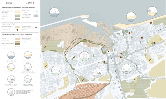
The '''masterplan''' includes goals and actions on both larger and smaller scale, | |||
focusing on the ''WATERFRONT'' (highlighting the area of dunes, protected by NATURA 2000, and the BAREER OF THE PORT on the west side); | |||
and on the ''INTERLAND'' (with the existing system of parks, green corridors, gardens and SHARED GARDENS). | |||
The '''actions''' will include: | |||
- Thickening of the coastline | |||
- Sustainable water treatment plants against the pollution | |||
- Extension of the existing net of shared gardens | |||
- Redevelopment of the green areas along the canals | |||
'''Bigger scale interventions''' will include, instead: | |||
- New activities and facilities on the shore | |||
- Green filter system for industrial areas | |||
- Shared gardens and didactic farms | |||
- Protection of submarine heritage (2ww shipwrecks visitable with diving activities) | |||
- Identification & conversion of non working areas for temporary installations for art and culture in order to promote tourism activities in every season of the year and avoid exclusive intensive mass tourism in just one season and in just one part of the town. | |||
<gallery caption=" " widths="600px" heights="350px" perrow="1"> | |||
File:MasterplanoUNICO.jpg|'''''Masterplan''' - spatial strategies - goals and actions'' | |||
</gallery> | |||
<gallery caption=" " widths="500px" heights="300px" perrow="1"> | |||
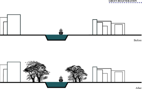
File:Strategy trnsct.png|''The transect shows some points that summarize the main interventions of our project. There are shared gardens, which could be located in larger green areas. The most degraded channel margins are regenerated with new green. The coast falls into two interventions: one for beach nourishment and the creation of a pedestrian and cycle path.'' | |||
File:Green regeneration.png|''The margins of the canal before and after the redevelopment of the green'' | |||
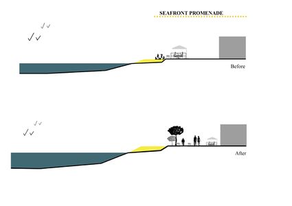
File:Seafront promenade.jpeg|''The creation of a cycle and pedestrian path that separates the urban from the beach'' | |||
File:Nourishment coast.jpeg|''The last intervention,re-proposed by a project idea that analyzed the problem of urbanization towards the east, on the coast contrasts the problem of the wind, with the insertion of trees, and the rise of the sea with the increase of the sandy area.'' | |||
</gallery> | </gallery> | ||
== C.3 From Theory of Change to Implementation == | == C.3 From Theory of Change to Implementation == | ||
''For the interventions described above, it is necessary to comply with a gradual governance process that can involve a multiplicity of actors who have the role of financing the interventions. It is therefore necessary that these actors are associated with a common vision with respect to the interventions. The actors involved in the governance process are manifold, in our case the main ones are the region of upper France, the municipality of Dunkerque and the EU support programs to which are added the various stakeholders and private users who have a role functional in the success of the interventions. Taking into consideration the various political and bureaucratic procedures, we hypothesized a timetable for the realization of our main interventions.'' | |||
<gallery caption=" " widths="500px" heights="200px" perrow="1"> | <gallery caption=" " widths="500px" heights="200px" perrow="1"> | ||
File: | File:Governance process and funding.jpg|''Governance process and funding'' | ||
File: | File:Timeline masterplan.jpg|''Interventions timeline'' | ||
</gallery> | </gallery> | ||
== C.4 References == | == C.4 References == | ||
'''POLLUTION''' | |||
- ''Interactive Map of Eutrophication & Hypoxia:'' https://www.wri.org/media/maps/eutrophication/fullscreen.html | |||
- http://www.dunkerque-port.fr/fr/activites-commerciales/activites-industrielles-port-dunkerque.html | |||
- https://www.dunkerquelng.com/4/securite-et-environnement#enjeux-environnementaux | |||
'''EXISTING PLANS''' | |||
- ''BIODIVERSITY IN THE CITY :'' https://www.ville-dunkerque.fr/vie-quotidienne/developpement-durable/la-biodiversite-en-ville | |||
- ''MUNICIPAL CLIMATE PLAN :'' https://www.ville-dunkerque.fr/vie-quotidienne/developpement-durable/plan-climat-municipal | |||
- ''SHARED GARDENS :'' https://www.ville-dunkerque.fr/vie-quotidienne/developpement-durable/les-jardins-partages | |||
- ''10000-TREES PLAN :'' https://www.ville-dunkerque.fr/vie-quotidienne/plan-10-000-arbres | |||
'''PUBLIC TRANSPORT''' | |||
- https://www.dkbus.com/ | |||
- https://www.dkbus.com/ftp/FR_document/Capture%20plan%20station%20Dkv%C3%A9lo.PNG | |||
- https://www.dkbus.com/ftp/documents/DKbusPlanreseau20200106web.pdf | |||
'''SUSTAINABILITY''' | |||
- https://climate-adapt.eea.europa.eu/countries-regions/transnational-regions/atlantic-area | |||
- https://bluehealth2020.eu/projects/anne-kanal/ | |||
- https://www.nuovi-turismi.com/ecoturismo-buone-pratiche-e-certificazioni-alberghiere/ | |||
- https://9a0efb03-d474-404a-84fd-2ddc24916544.filesusr.com/ugd/8f3e40_efcdebf8a09f492ca09bf399b0da0e01.pdf | |||
- https://it.euronews.com/2012/02/21/lo-spirito-sostenibile-di-dunkerque | |||
= D. Process Reflection = | = D. Process Reflection = | ||
Latest revision as of 11:47, 9 April 2020
>>>back to working groups overview
| Area | Dunkerque (East) | |
| Place | Dunkerque | |
| Country | France | |
| Topics | Environmental Heritage - Tourism and Commerce - Land Consumption | |
| Author(s) | Ambrosino Mara, Hassler Alessandra, Savelli Giulia, Scoppola Pietro, Guerra Antonio | |

| ||
Rationale
- Why do you think this case is relevant? What is your hypothesis considering the landscape challenges?
- Format: 3-4 sentences
Location and scope
You can edit this map with the map editor
A Landscape System Analysis
A.1 Landscape layers and their system context
Geomorphology, landscape units and coastal typology
First of all in our area ,Dunquerke east, we identified the 3 keywords,as we can see, that return our image of thearea for us. The first, ENVIRONMENTAL HERITAGE, highlights the strong presence of the natural historical heritage of the area which leads us to identify the second keyword: TOURISM AND COMMERCE. Dunquerke area attracts a large tourist flow for its coast which performs a dual function, economic and environmental. However, these two functions clashed with each other and the economic function prevailed over the environmental one. For these reasons the urbanized part subtracts soil from natural part; hence the choice of the third keyword is : LAND CONSUMPTION.
The characteristic elements of the coast are the sand dunes, are result of the natural effects produced by the wind and waves. The dunes outline the course of the soil which is slightly steep towards the sea. Moreover, these natural barriers mark the border between nature and urbanized environment, marked by docks. The docks are the center of the anthropized system formed by the port and industries, tourist and economic centers. These functions are in contrast with the surrounding naturalistic system but together they characterize the coast line of the area.
-
 Key words
 -
 Costal Typology


Land use
Dunkirk is characterized by three main functional areas: on the west side of our area, as we can see, there is an intensified presence of industrial activities because the port is the economic core of the area, the residential area is developed in the south area where there is a strong presence of historic buildings. Therefore on the east side there is a residential area characterized by a resort because it is not industrialized and still in direct contact with the coast line. All these functions, however, are not well connected to each other so in the future we assume that the predominant land use will be the infrastructure system.
-
 actual land use of the area
 -
 actual top view of the area from google maps
 -
 legend


Green/blue infrastructure
The main green and blue infrastructure is the coast line. This is characterized, as previously mentioned, from the dunes and the largest run east of the Belgian coast. The "dunes flamandes" (Flemish dunes) run to the east on the Belgian border. It is an absolutely unique ecosystem that hosts hundreds of botanical species. The beach is extended continuously over 15 km. Discovered at low tide, the vast zone is sometimes bordered by dunes.
The blue infrastructures are characterized by the presence of water channels that run into hinterland and by the port that divides the anthropic system from the naturalistic one. Green infrastructures are characterized by a large presence of green soil which differs from agricultural and woodland soil. The connection between the green of the agricultural soils and the blue of the sea is interrupted by the presence of urbanized soil.
-
 green and blue infrastructures
 -
 actual top view of the area from google maps
 -
 legend


Actors and stakeholders
In Dunkerque the primary type of stakeholders is organizations and governmental associations in the area. The district is under the supervision of the municipality of Dunkerque which is one of the main stakeholders with a high level of interest and the influence. Therefore, the French National council for coastline is the highest-ranked interest organization in the area that is caring for landscape and it is responsible of the environmental issues of the area. The council is nominee by the national government every 4 years.
Port industries also have a considerable influence as they strongly affect the economy of the area. Local people, tourists, investors, and businessman are considering as the second type of stakeholders. Each of them has a different role in the local society as they influence both social environmental and economic factors of the area. They can lead by the first group of the stakeholders to improve and promote the development factors of the area of Dunkerque.
-
 Main Actors and Stakeholders in Dunkerque East

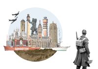
Sacred spaces and heritage
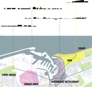
The place that more than any other in Dunkerque holds a strong cultural value is the port, which contributed to the birth and the development of the city itself over the centuries. It started out as a centre of herring fishing under the Counts of Flanders in the 11th century and began to engage in commercial traffic after 1350 as a result of contacts with Holland and England. Its expansion continued until the mid-18th century, alternating with the numerous bombings and reconstructions in the times of wars, which contributed to its modifications.
The skyline of Dunkerque is then spread out horizontally over the sea, that makes it easy to catch the vertical elements that rise over the civil buildings, like towers, bell towers and lighthouses, most of which are protected by UNESCO and represent a strong part of the cultural heritage of the city. Among the most relevant:
- La Tour du Leughenaer (1450)
- Le beffroi de Dunkerque (xv sec, monument historique depuis 1840)
- Le phare de Dunkerque ou phare du Risban (1842)
- L’hôtel de ville de Dunkerque (1897-1901, its belfry was declared a UNESCO World Heritage Site in 2005)
- Feu de Saint-Pol (1937)
Dunkirk was also the scene of the historic evacuation of the British Expeditionary Force from France in May and June 1940. Known as Operation Dynamo, it was the largest evacuation of Allied forces during the Second World War. That's why the places of the wars that took place in Dunkerque had a great impact in changing the anthropic system of the city and, most of all, its symbolical value, with the introduction of many memorial sites and cemeteries (like the "Dunkirk Memorial", unveiled in Dunkerque on 29 June 1957 by Queen Elizabeth).
But the natural system of the city is rich in cultural heritage as well, thanks to the Dunes of the Flemish maritime plain, which characterize the coastline and are included in the List of Sites of Community interest for Natura 2000.
-
 Dunkerque watercolor plan in 646 _ Click to see the map!
 -
 Map of Dunkerque in 1400 _ Click to see the map!
 -
 The naval park arsenal at the end of the 18th century _ Click to see the map!
 -
 Artwork of Dunkerque heritage


Visual appearance and landscape narrative
Due to its historical and symbolic value, Dunkerque has been the subject of several movies and visual artpieces:
“Week-end à Zuydcoote” (1964) and “Dunkirk” (2017), are just two of the famous movies which take place during Operation Dynamo in Second World War, under the German bombardments;
“Karnaval” (1999), instead, takes place during the traditional Dunkirk Carnival, catching another face of the cultural heritage of this land;
In the music field, the “Cantate à Jean Bart”, popular "anthem" of Dunkerque, is a song played on the evening of the Dunkirk Band directly in front of the statue of the hero, where the crowd of "carnivals" meet and sing on their knees, with arms stretched towards the sky.
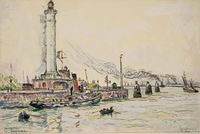
Also many painters, like Jean Baptiste Camille Corot, Charles Ernest Cundall, Paul Signac and many other local and contemporary artists, celebrated the beauty of Dunkerque’s landscape in their paintings, focusing on the coastal landscape with the sea and the sand dunes.
-
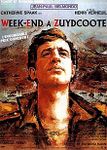 Week-end à Zuydcoote (film, 1964)
 -
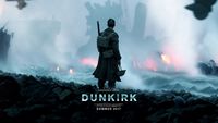 Dunkerque (film, 2017)
 -
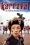 Karnaval (film, 1999)
 -
 “Cantate à Jean Bart”
 -
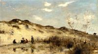 A dune in Dunkerque, Jean Baptiste Camille Corot
 -
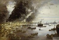 The withdrawal from Dunkirk, Charles Ernest Cundall (1940)
 -
 Dunkerque, Paul Signac
 -
 The harbour of Dunkerque, Alexis Vollon


.jpg)

A.2 Summary of your landscape system analysis and your development targets
After our analysis we can explain the weakness and the strongness of Dunkerque by the DPSIR analysis model. Surely our Driving Forces are the cultural points like Museum Dunkerque, Lieù d’Art et Action Contemporane de Dunkerque, FRAC and the two ship Duchesse Anne and Sandettiè. Another strenght is the turist beach like Malo les Bains. About the Pressure, instead, one of the weakness is the impact given by the industries and the urban contest fragmentation. The States of the Green and Blu infrastructure are interrupted by the urban contest. A great value to improve the urban contest is given by the municipality that institueted the “Free Public Transport” which caused the economic growth and a less impact on the Climate change. By this way the municipality try to Response to the problems that we have shown before.
-
explain your analysis briefly in the caption
-
 State of facts If the actual driving forces would continue as they do

A.3 Theory reflection
- Reflect on at least three international policy documents in relation to their local landscape case
- choose one international, one European and one national document
- You can choose references from our reading list
- Scope: 250 words
A.4 References
- give a full list of the references you have used for this section
Phase B: Landscape Evaluation and Assessment
B.1 Assessment Strategy
- In the face of the analysis that we made on the area we found that we could operate at best on the zone by powering biodiversity, landuse and accessibility. This analysis has been confirmed by a survey addressed to Danquerke citizien which validate that we have been able to identify the focal points to ensure a densest and closer process of development and protection of the territory.
B.2 Mapping
- As defined by your assessment strategy you conduct the mapping and present your findings here
- As a minimum, at least three different themes need to be mapped, you may choose more if needed
-
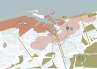
 Two important themes emerge on this map. There are horizontal and vertical connections that connect Hinteland and the sea. Just a single axis does not reach the sea because it is closed by the barrier formed by the industrial area. A proposed project could be to connect the western part of the Dunkirk canal with the eastern part to bring it closer to the waterfront.
 -
 This map represents land use in terms of inhabited buildings, accommodation facilities, industries, agriculture and public green as they appear today. We observed these data on the basis of our previous analyzes and the questionnaire we submitted to the population of the area. The main urban changes date back to the second post-war period till 70s, however an increase in urbanized land in the coastal area can be noted in the last twenty years with a consequent increase in accommodation facilities, especially airbnbs (shown on the map with the red icon).
 -
 From the mapping of ecosystem services and from the study on the biodiversity of the territory, it emerged that our study area, by its nature, offers many benefits. In particular, the coast has a great biodiversity with the presence of tree species on its dunes and the fauna of its waters. In the hinterland there are various protected green areas where the typical fauna of the area is safeguarded but unfortunately, there is a great economic tendency to exploit the coast through the port which makes polluted waters at the expense of the species that live there.


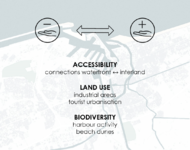
B.3 Problem definition and priority setting
By mapping the three major aspects we chose to focus on (ACCESSIBILITY, LAND USE, BIODIVERSITY), what we were able to deduce was that:
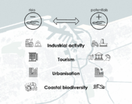
- There are different connections from the waterfront to the inner city and back at the moment, which might be a good starting point to work on to, in order to reclose the split which there is now between the coastline and the interland, due to the uncontrolled urbanisation of some activities.
- In fact, the predominance of the industrial areas and the big port, in addition to the tourist urbanisation, are causing a deep cut in the landscape, making the coast not so easy to access.
- Moreover, the industrial and harbour activity, got the pollution increasing over the years, having the local population to fear for the safety of the typical beach dunes which characterize the landscape.
For each of these aspects, we deduced, then, the risks and the potentials, as two pieces of a coin.
In fact, as it’s important to be aware of the dangers of the uncontrolled expansion of the industrial and harbour activities and of the tourist urbanization, so it is necessary to consider their role in the economy growth of the city and their potential in terms of agriculture and cultural heritage.
As well as the density of buildings in the center, which make it hard to get access to the coast today, it’s still well connected so it could be easily improved with the development of the existing infrastructures turned to green.
And in last, the biodiversity of the coast, whose risk is represented by pollution and climate change, has of course a great potential for its own nature.
After mapping this system of pros and cons, we could set the goals for assessing the landscape. Those are:
- Encouraging the agriculture and the local activities, in order to try to balance the predominance of industry
- Protecting the sealife and the biodiversity of the landscape from water pollution caused by harbour and industries and studying possible measures of sea level rise prevention
- Finding a sustainable way of controlling urban development, and reinforcing the existing connections to the waterfront with green infrastructures
- Finding possible solutions for sustainable tourism
-
 Assessment synthesis
 -
 Evaluation of Risks and Potentials
 -
 Risks and Potentials map
 -
 Priorities and targets


B.4 Theory reflection
The main difficulty we found during the second phase of the project was to set goals without having the possibility to study the area personally, so we tried to obtain updated datas about the environment and the perceptions of locals by writing a survey.
From this we could obtain interesting answers about the risks and potentials as felt by the population: most of the answers, in fact, were from people who have been living in Dunkerque since their birth. We asked them about the importance of agriculture and the impact of harbour industry on the landscape and on the environment, getting very interesting answers, feeling the affection of locals for their city and their worry of losing the biodiversity due to pollution. It also helped us evaluating their ideas about the safeguard of the landscape, the prevention of risks and the elements of potentials which were essential in setting the goals for the project.


B.5 References
- give a full list of the references you have used for this section
Phase C – Strategy and Master Plan
C.1 Goal Setting
Stepping back to the points we set previously [previously ],
the goals we aimed to define in our project could be reflected as some of the points of SDGs (Agenda 2030) like as:
11. SUSTAINABLE CITIES AND COMMUNITIES Supported by our will to set strategies to:
- Promote sustainable tourism (Organic agriculture / 0 km origin; Technologies for water saving; Ecologically oriented renovation of hotel facilities for the choice of renewable energy sources; Mobility and Public Transport; Promotion and Knowledge of monuments and areas of historical; artistic and natural interest; Highlighting territorial cultural heritage)
- Reinforcement of connections to the waterfront (green infrastructures);
12. RESPONSIBLE CONSUMPTION AND PRODUCTION with the encouragement of agriculture itself;
13. CLIMATE ACTION with the Redesign of the coastline;
14. LIFE UNDER WATER & 15. LIFE ON LAND With actions against pollution and protection of the sealife and biodiversity of the landscape heritage (like the sand dunes).
C.2 Spatial Strategy and Transect
During the process, we had to face that part of our goals was already supported by the municipality with many plans, which promote sustainable activities in the town, like the dense GREEN INFRASTRUCTURE SYSTEM, a plan for 10-THOUSAND TREES, a plan for SHARED GARDENS and a BIKE SHARING system, with 46 stations and long trails that cover all the city.
Also, on the contrary, one big problem we had to face was the pollution of the sea, in particular in the area of the port, with the consequential problem of Eutrophication & Hypoxia. (All the websites for references are at the end of this section)
The masterplan includes goals and actions on both larger and smaller scale,
focusing on the WATERFRONT (highlighting the area of dunes, protected by NATURA 2000, and the BAREER OF THE PORT on the west side);
and on the INTERLAND (with the existing system of parks, green corridors, gardens and SHARED GARDENS).
The actions will include:
- Thickening of the coastline
- Sustainable water treatment plants against the pollution
- Extension of the existing net of shared gardens
- Redevelopment of the green areas along the canals
Bigger scale interventions will include, instead:
- New activities and facilities on the shore
- Green filter system for industrial areas
- Shared gardens and didactic farms
- Protection of submarine heritage (2ww shipwrecks visitable with diving activities)
- Identification & conversion of non working areas for temporary installations for art and culture in order to promote tourism activities in every season of the year and avoid exclusive intensive mass tourism in just one season and in just one part of the town.
-
 Masterplan - spatial strategies - goals and actions

-
 The transect shows some points that summarize the main interventions of our project. There are shared gardens, which could be located in larger green areas. The most degraded channel margins are regenerated with new green. The coast falls into two interventions: one for beach nourishment and the creation of a pedestrian and cycle path.
 -
 The margins of the canal before and after the redevelopment of the green
 -
 The creation of a cycle and pedestrian path that separates the urban from the beach
 -
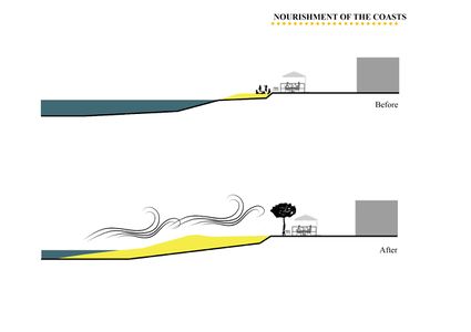 The last intervention,re-proposed by a project idea that analyzed the problem of urbanization towards the east, on the coast contrasts the problem of the wind, with the insertion of trees, and the rise of the sea with the increase of the sandy area.


C.3 From Theory of Change to Implementation
For the interventions described above, it is necessary to comply with a gradual governance process that can involve a multiplicity of actors who have the role of financing the interventions. It is therefore necessary that these actors are associated with a common vision with respect to the interventions. The actors involved in the governance process are manifold, in our case the main ones are the region of upper France, the municipality of Dunkerque and the EU support programs to which are added the various stakeholders and private users who have a role functional in the success of the interventions. Taking into consideration the various political and bureaucratic procedures, we hypothesized a timetable for the realization of our main interventions.
-
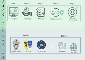 Governance process and funding
 -
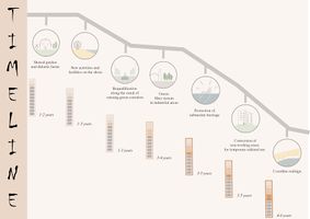 Interventions timeline


C.4 References
POLLUTION
- Interactive Map of Eutrophication & Hypoxia: https://www.wri.org/media/maps/eutrophication/fullscreen.html
- http://www.dunkerque-port.fr/fr/activites-commerciales/activites-industrielles-port-dunkerque.html
- https://www.dunkerquelng.com/4/securite-et-environnement#enjeux-environnementaux
EXISTING PLANS
- BIODIVERSITY IN THE CITY : https://www.ville-dunkerque.fr/vie-quotidienne/developpement-durable/la-biodiversite-en-ville
- MUNICIPAL CLIMATE PLAN : https://www.ville-dunkerque.fr/vie-quotidienne/developpement-durable/plan-climat-municipal
- SHARED GARDENS : https://www.ville-dunkerque.fr/vie-quotidienne/developpement-durable/les-jardins-partages
- 10000-TREES PLAN : https://www.ville-dunkerque.fr/vie-quotidienne/plan-10-000-arbres
PUBLIC TRANSPORT
- https://www.dkbus.com/ftp/FR_document/Capture%20plan%20station%20Dkv%C3%A9lo.PNG
- https://www.dkbus.com/ftp/documents/DKbusPlanreseau20200106web.pdf
SUSTAINABILITY
- https://climate-adapt.eea.europa.eu/countries-regions/transnational-regions/atlantic-area
- https://bluehealth2020.eu/projects/anne-kanal/
- https://www.nuovi-turismi.com/ecoturismo-buone-pratiche-e-certificazioni-alberghiere/
- https://it.euronews.com/2012/02/21/lo-spirito-sostenibile-di-dunkerque
D. Process Reflection
- Reflect in your intercultural and interdisciplinary team on the outcomes of your study
- Which limitations were you facing?
- What have you learnt from each other?
- What would you do differently next time?
- You can also use diagrams/visuals
- 250 words text