COLAND Case Study 2020 - Knokke: Difference between revisions
Nuciu.maria (talk | contribs) |
|||
| Line 164: | Line 164: | ||
<gallery caption=" " widths="500px" heights="200px" perrow="1"> | <gallery caption=" " widths="500px" heights="200px" perrow="1"> | ||
File:Zona de coasta 1 | File:Zona de coasta 2.1.png|''Tourist potential in the coastal area'' | ||
File:Zona verde si albastra.png|''Tourist potential in the green and blue area'' | File:Zona verde si albastra.png|''Tourist potential in the green and blue area'' | ||
File:Demografie si migratie.jpg|''The tourist movement'' | File:Demografie si migratie.jpg|''The tourist movement'' | ||
Revision as of 18:03, 10 April 2020
>>>back to working groups overview
| Area | Knokke - Dutch Border | |
| Place | Knokke | |
| Country | Belgium and Netherlands | |
| Topics | Transboundary area; Wetland of international importance; Natura 2000; Green and blue infrastructure | |
| Author(s) | Stefania Legeny, Irina Midoni, Roxana Ignat, Carla Gavrilescu, Maria Nuciu, Ioana Ciuca, Ana Glisic | |

| ||
Rationale
- Knokke, a town in the municipality of Knokke-Heist, located in the province of West Flanders in Flanders, Belgium, which is the most north-eastern coastalzone. Knokke is well known for its beaches and for the dike system.
- Land use has changed with economic, technological and cultural development of the area, and a large area of land is a Natura 2000 habitat.
- The green infrastructure of the area is primarily comprised of the Natura 2000 habitat network. It covers a large percentage of the area under forest, humid habitats, hedges, tufts and arable land, the coastline, agricultural land, a branched cycle path system, etc.
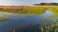
- The coastal area is constantly moving, a major factor is the erosion in the surface and the sedimentation processes, in addition to the human activities.
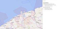
Location and scope
You can edit this map with the map editor
A Landscape System Analysis
A.1 Landscape layers and their system context
Geomorphology, landscape units and coastal typology
- Belgium can be divided into three main geographical regions, such as: in the north-west a coastal plain area, a central plateau area and in the southeast a high plateau of the Ardennes.
- With a coastal area of approximately 98 kilometers, bordering the southeastern part of the North Sea, the influence of the sea is felt in the cities of Belgium that are now protected against flooding.Belgium has a very small coastal area, but it hosts several types of coastal habitats, which are important for the flora and fauna of the area, such as: underground sand banks, sandy beaches, intertidal sand dunes, sand dunes and polder meadows. The coastal area is constantly moving, a major factor is the erosion in the surface and the sedimentation processes, in addition to the human activities, which can have a positive and negative impact.
- From a geological point of view, the territory of Belgium comprises various typologies formed over millions of years, in the north being cenozoic deposits consisting mostly of marine and unconsolidated sediments, in the south, the Paleozoic rocks dominate on large areas.
- The main human activities in the Belgian coast area include: extraction, maritime transport, fishing, industry and mining. All the activities have led to a degradation of the Belgian coast area, a qualitative and quantitative degradation of the coastal ecosystem. The managerial responsibility of governing the institutions is limited to the manifestation of state power from the federal, regional and local areas.
-
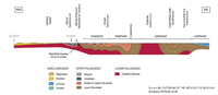 The geology of Belgium
 -
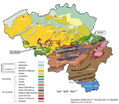 Geological eras of Belgium


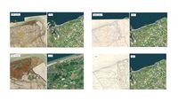
Land use
The most noticeable changes in land use from the 18th century to the present occur in the coastal zone. In the beginning of 20th century a dock was opened on the western border of the case study area and the town of Knokke has been expanding extensively towards the coast, an area once dominated by sand dunes. The percentage of area under discontinuous urban tissue and arable land with one-year crops is increasing. The Zwin, border and nature park, originally part of the channel that led to the fortification of the city of Suis, and the port between the border of the two countries - Belgium and the Netherlands, is today a less moist area of international importance. There is a tourist resort between the town of Knokka and nature park Zwin. Land use has changed with economic, technological and cultural development of the area. The most important directions of transport infrastructure from the 18th century to the present have remained unchanged in some sections. Cities were expanding towards potential tourist sites. However, in the 21st century, it seems that all the resources for this purpose are exploited and that further enhancement of tourism development can endanger the environment. Also, a large area of land is a Natura 2000 habitat.
-
 History of Knokke
 -
 Corine Land Cover Changes 1990-2018
 -
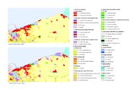
 Natura 2000 Sites


Green/blue infrastructure
Natura 2000 sites:
- Dune areas and Zwin (Habitats Directive Sites)
- The Zwin (Birds Directive Sites)
- Zwin and Kievittepolder (Habitats Directive Sites and Birds Directive Sites)
The green infrastructure of the area is primarily comprised of the Natura 2000 habitat network. It covers a large percentage of the area under forest, humid habitats, hedges, tufts and arable land, the coastline, agricultural land, a branched cycle path system, etc.
Natura 2000 envisages measures to preserve protected habitats. This ensures their relative stability and prevents ecosystem damage. Green and blue infrastructure that is not part of recognized, protected habitats can be disrupted if the uncontrolled and reckless development of tourist settlements or other facilities that make these areas non-porous. Further development of climate change in the direction it is headed today will result in the primary drying up of temporary wet habitats and smaller water areas. Increasing green and blue infrastructure will positively influence the further development of sustainable mobility (cycling, walking) and fostering social gatherings (social aspect) by creating suitable microclimatic and macro-climatic conditions. Disrupting the blue and green infrastructure will reduce the economic gains from tourism.
-
 High Resolution Layers 2015 - Copernicus
 -
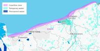 Coastline and Water Areas - Copernicus 2015
 -
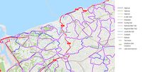 Transport infrastructure
 -
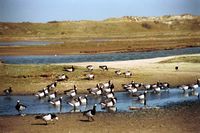
 Sea lavender on the saltmarsh - The Zwin


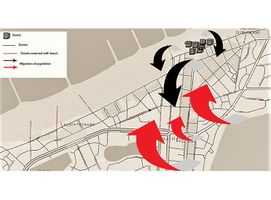
Actors and stakeholders
In this area, changes are caused of the erosion of the coast and the excessive building on the coast. Because of these changes, the beach is disturbed. The dwellers have the smallest power over those events but it's in their best interest to do something. On the other hand, the local authorities have more influence on those changes. Tourists have less power and less effect because of the short period of summer season.
-
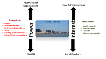 Power Map

Sacred spaces and heritage
- Which places/elements hold cultural value and to whom?
- You may add a map and some images, please also explain in your caption why these elements are valuable
-
 Zwin Nature Reserve
 -
 Freedom museum
 -
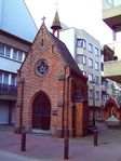 Fisherman chapel


Visual appearance and landscape narrative
- Knokke is known for its beautiful landscapes therefore is an inspiration for numerous artists to capture different aspects such as the magical dunes or windmills. Camille Pissarro is one of the artists that was mesmerized by this area, so he created in 1894 "The Dunes at Knokke" oil on Canvas, and "Windmill at Knokke", both paintings show the Impressionism style and highlight the mystical nature that surrounds Knokke.
-
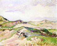 The Dunes at Knokke
 -
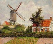 Windmill at Knokke-Belgium
 -
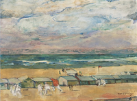 Beach with Beach


A.2 Summary of your landscape system analysis and your development targets
Sustainable Development Goals at risk: Goal 3: Good Health and Well-being, Goal 11: Sustainable Cities and Communities, Goal 13: Climate Action, Goal 14: Life Below Water, Goal 15: Life on land, Goal 17: Partnerships to achieve the Goal.
Based on the historical development of the landscape and it’s current state it can be concluded in which way it will develop. Visible changes in the landscape in the next period will refer to the expanding of the city core and increasing of non-porous area to the city industrial zones. Density of population will increase and already damaged habitats in the tourist zone will degrade. The appearance of erosion is inevitable. Already fragmented landscape will lose the connection which allows the movement of matter and organisms. It can come to endagering of existing corridors. Increased density of population and overload of significant natural and historical features of the landscape will create invisible negative sources disturbing environmental health and quality of life. Habitats recognised through Natura 2000 program disable uncontrolled development of the surrounding parts of landscape, but to prevent indirect disturbing of this habitats under the influence of urbanised areas existance of buffer zones is necessary.
-
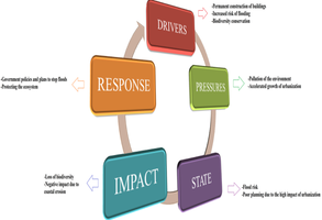 DPSIR analysis of the Knokke area

-
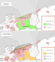 Hypothesis for The Knokke Area

A.3 Theory reflection
- Reflect on at least three international policy documents in relation to their local landscape case
- choose one international, one European and one national document
- You can choose references from our reading list
- Scope: 250 words
- United Nations. Sustainable Development Goals
- European Commission Natura 2000
- Decleer, 2008: Ecological Restoration in Flanders
A.4 References
- http://en.topimpressionists.com/TopImpressionists.nsf/A?Open&A=8EWDKX&fbclid=IwAR1l8zhmwsLG7T_acaR65iDT995BspjKcQxkU_6AfIGtGN5XVmY7WN1KfEw
- https://www.wikiart.org/en/camille-pissarro/windmill-at-knokke-belgium-1894?fbclid=IwAR2wr1THcwtzaIMTThYsjpXPd6mdeEbkaIeWQaCWoDAjTHuteF4c5Gtr14I
- https://www.researchgate.net/publication/264993155_An_overview_of_the_Geology_of_Belgium
- https://imcore.files.wordpress.com/2009/10/belgian_coast_case_study1.pdf
- https://www.persee.fr/doc/rjenv_0397-0299_2001_hos_26_1_3852
- https://ec.europa.eu/eurostat/documents/3217494/5728589/KS-HA-11-001-13-EN.PDF/c0dd33ed-0db2-4d8b-ae03-26d9bf3e57fc?version=1.0
- https://mapire.eu/en/map/belgium-1846/
- https://mapire.eu/en/map/europe-18century-firstsurvey/
- https://natura2000.eea.europa.eu/#
- https://land.copernicus.eu/
- https://ec.europa.eu/environment/archives/life/publications/lifepublications/lifefocus/documents/grassland.pdf
- https://land.copernicus.eu/
Phase B: Landscape Evaluation and Assessment
B.1 Assessment Strategy
- Our assessment strategy is to maintain the balance between nature and anthropogenic activities, because it is important to consider the sustainability elements.When we think about the natural factors, since the 1999 the Flemish Gouverment acquiired 15,000 ha of forests, dunes and nature areas,even if some dunes are private property, the Gouverment can limit property rights on lands that belongs to private owners, in order to reduce excesiv constructions.We try to keep in mind that not all anthropic activities have a destructiv effect, in case of erosion of coastal area, Flemish Gouverment step up through:monitoring, inspecting and maintaining coastal infrastructure on a daily basis
B.2 Mapping
- As defined by your assessment strategy you conduct the mapping and present your findings here
- As a minimum, at least three different themes need to be mapped, you may choose more if needed
-
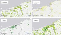
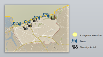 Tourist potential in the coastal area
 -
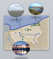 Tourist potential in the green and blue area
 -
 The tourist movement


B.3 Problem definition and priority setting
- In the Knokke area there are some problems like the excessive construction who will end up with suprapopulation, erosion of the coast, the pollution of the zone and the low level of vegetation in this area. On the other hand there are some potentials points who can rise the potential of the coast like the beach, tourists, historical monuments and artefacts, and the infrastructure.All the thins written above are connected with each other. Whit a massive population the tourists are less, the low level of vegetation change the climate and without vegetation the pollution of the air is very high. If the erosion will continue the beach will be very affected and with that, the number of tourists who will come will fall down, but there are some historical places who can attract some tourists too, but not in a big number.
-
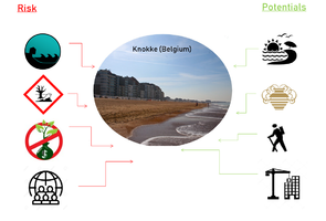 Problems/potentials scheme

B.4 Theory reflection
- When we think about our Critical Reflection , we encountered positive and negative parts, the good part is given by the presence of the touristic potential, due to the beach areas, and the not so good part, it is because of legal aspects of things.The limits appear according to the hierachy of state power, and the diffrence between the private and the public domain, wich fallows different rules moast of the time.
B.5 References
- give a full list of the references you have used for this section
Phase C – Strategy and Master Plan
C.1 Goal Setting
- Regarding the goals of this study, bu beeing a member of the European Union , it is important to achieve the goals of Sustainable Developement in total, from 1 to 17.But for a well developed country like Belgium, it is safe to assume that the targets between 1 to 8, have already been reached.We focused our attention on the rest of the goals, which are for the future, as things are constantly changing and evolving, such as:sustainable cities, industry and innovation, actions for climate change, biodiversity protection, competent institutions that are made to ensure peace and well-being.
C.2 Spatial Strategy and Transect
- When we thought about making the graphic representation, we initially analysed the elements of our study area, what makes it important and unique? As far as tourism goes, the main attraction of Knokke is the beach. We did not want to put more pressure on the environment, but instead our vision is to highlight the elements already existing in this area, like the Zwin Nature Park, a natural reserve, famous for its large fauna (white storks) and flora (lavender).Another important aspects are the five beaches of Knokke region, all being easily accessible from the town.
- Regarding the transect part, we divided the area into two parts: anthropogenic and natural areas.The anthropogenic part is composed of urban area, and the natural part is composed from the coastal zone and natural reserve.Based on the most important findings in our study area, we split them in three (natural reserve,coastal and urban area), because this way is easier to track and discuss the implementation we want to bring.
- Normally in natural areas we would not want to implement constructions, in order to not put un extra pressure on the environment, so we would add only constructions that could help the natural areas in a sustainable way.For the coastal area, we want to implement sandy dams along the coastline, to help slow down the coastal erosion over time.Next, we want to implement devices that generate green energy, using waves speed, and finally we want to add green areas along the coast, to balance out with the multitude of buildings around.And for the natural reserve, nothing can be implemented because it is a natural park, prohibited by law to have construction in progress.
- In the urban area, we want to use the most attractive touristic points, such as museums, art gallerys and bicycle rental stands, combining these three elements together and the result is a bicycle route where you can visit the points of tourist interest.
-
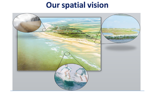 Spatial vision in the study area
 -
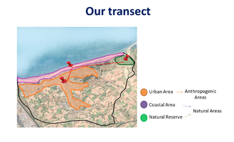 The main focus areas of the study area
 -
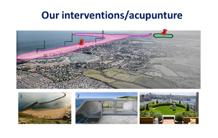 Interventions in the natural area
 -
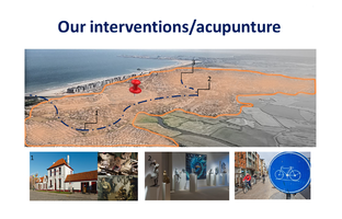 Interventions in the urban area


C.3 From Theory of Change to Implementation
- For implementing your vision: Which partnerships are needed? Which governance model is required?
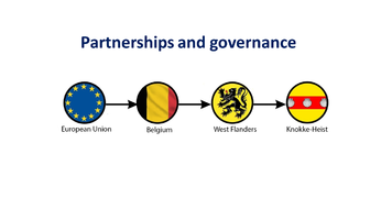
Knokke-Heist is a municipality in the Belgium province of West Flanders. When Belgium entered in European Union, the country benefits of certain facilities. Knokke-Heist is in the coastal area and there is a project initiated by the European Union and European Commission named "North Sea Region Programme". The purpose of the project is to make the North Sea Region a better place to live, work and invest in. Belgium continued the measures implemented by the project by building digs to stop the erosion in the affected areas.
-
 Distribution of power in the state
 -
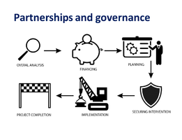 Schematic implementation of projects


In order to make a project and to finish it there are some steps to follow:
First of all overall analysis, when a project is started an overview is required in order to vizualize the project.
The financing can be from European Union or other source of income.
Planning the project is the next big step right before the implementation of it. It must be planned and tuned every detail.
Securing intervention is the legality of the project proved in official documents.
When all is done, and aproved, the implementation can begin. This is the step where the project comes to life.
After some years or months of work the project is completed.
C.4 References
- give a full list of the references you have used for this section
D. Process Reflection
- The best way to talk about the Process Reflection is through the Kruger Effect, which means the less information we had about our area, the more we were confident that we would handle it.We are now at a point where we can say that is a complicated topic.We have also faced the lack of certain key information, like the official laws and so on.