Novodari-Mamaia: Difference between revisions
| Line 69: | Line 69: | ||
<gallery caption=" " widths="200px" heights="150px" perrow="5"> | <gallery caption=" " widths="200px" heights="150px" perrow="5"> | ||
File:Siutghiol Lake Navodari Mamaia case study.jpg|''Siutghiol Lake'' | File:Siutghiol Lake Navodari Mamaia case study.jpg|''Siutghiol Lake'' | ||
File:Siutghiol Lake 2 Navodari Mamaia case study.jpg|''Siutghiol Lake'' | |||
File:Tasaul Lake Navodari Mamaia case study.jpg|''Tașaul Lake (Google maps - Satellite)'' | File:Tasaul Lake Navodari Mamaia case study.jpg|''Tașaul Lake (Google maps - Satellite)'' | ||
File:Corbu Lake Navodari Mamaia case study.jpg|''Corbu Lake (Google maps - Street View)'' | File:Corbu Lake Navodari Mamaia case study.jpg|''Corbu Lake (Google maps - Street View)'' | ||
Revision as of 11:42, 17 April 2018
>>>back to working groups overview
| Area | please enter the area name here | |
| Place | please enter the town/village name | |
| Country | please enter the country here | |
| Topics | please enter the main coast-related topics here | |
| Author(s) | Please enter your name(s)- optional | |

| ||
Rationale
- Why do you think this case is relevant? What is your hypothesis considering the landscape challenges?
- Format: 3-4 sentences
Location and scope
You can edit this map with the map editor
A Landscape System Analysis
A.1 Landscape layers and their system context
Geomorphology, landscape units and coastal typology
- Description of evolution, status quo and driving forces, is the coastal typology changing? Why is that? (approx 200 signs)
- add 1-2 graphical representations to the image gallery, you can add more if you like
-
add a caption
-
add a caption
Land use
- settlements, infrastructure, agriculture, resource extraction, natural areas, energy production...
- description of evolution, status quo and driving forces, is the land use likely to change? Why is that? (approx 200 signs)
- add 1-2 graphical representations to the image gallery, you can add more if you like
-
add a caption
-
add a caption
-
add a caption
Green/blue infrastructure
- What are the major potential elements of a green/blue infrastructure network? Are these likely to change/disappear? Why is that?
- You find my background material on green infrastructure in our reading list
- add 1-2 graphical representations to the image gallery, you can add more if you like
In the context of an urbanised environment, green and blue infrastructure is to be understood as all natural and semi-natural landscape elements that (could) form a green-blue network. It can refer to landscape elements on various spatial scale levels: from individual rows of trees to complete valley systems. Examples of green landscape elements are hedgerows, copses, bushes, orchards, woodlands, natural grasslands and ecological parks. Blue landscape elements are linked to water. They can be pools, ponds and pond systems, wadis, artificial buffer basins or water courses. Together they form the green-blue infrastructure.
In Năvodari-Mamaia coastal zone the major potential elements of blue infrastructure network are Siutghiol Lake (with Ovidiu island), Tașaul Lake, Corbu Lake, Poarta Albă-Midia Năvodari Canal and Aqua Magic Park. The green infrastructure elements are reprezented by hedgerows, trees, bushes and natural grasslands. Năvodari City is also known for its many green spaces, the most important being Ion Dobre Park, The Central Park and The Jilava Park. This elements representing the green and blue infrastructure are unlikely to disappear in the near future beacause most of them are natural landscape elements. Also, this components are important for economic growth, tourism, recreational activities and industry.
-
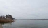 Siutghiol Lake
 -
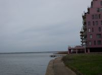 Siutghiol Lake
 -
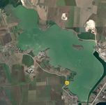 Tașaul Lake (Google maps - Satellite)
 -
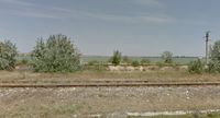 Corbu Lake (Google maps - Street View)
 -
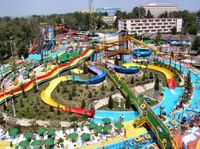 Aqua Magic Park
 -
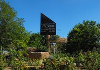 Ion Dobre Park


Actors and stakeholders
- Who is driving changes in this landscape? Who is affected by those changes?
- Draw a stakeholder and/or power map: Who is affected highly but with low power? Who has high power but is not affected?
-
add a caption
Sacred spaces and heritage
- Which places/elements hold cultural value and to whom?
- You may add a map and some images, please also explain in your caption why these elements are valuable
-
add a caption
-
add a caption
-
add a caption
Visual appearance and landscape narrative
- Which elements are essential for the landscape character?
- Has the landscape been painted or otherwise depicted, when and whom? Which elements are essential?
- Which narratives exist? Who has written about this landscape or depicted it in some way?
- You can add text and images
-
add a caption
-
add a caption
-
add a caption
A.2 Summary of you landscape system analysis and your development Targets
- You can summarize your findings with an DPSI(R) Model or a Spider Diagram
- Link back to the Sustainable Development Goals: Which goals are at risk?
- What is your hypothesis for this landscape?
- Visualise your hypothesis with one graphic/pict
- Are there any existing initiatives taking action in this landscape? Do you have a critical perspective on that?
- Add text and visuals
-
explain your analysis briefly in the caption
-
explain your hypthesis briefly in the caption
A.3 Theory reflection
- Reflect on at least three international policy documents in relation to their local landscape case
- choose one international, one European and one national document
- You can choose references from our reading list
- Scope: 250 words
A.4 References
- give a full list of the references you have used for this section
Phase B: Landscape Evaluation and Assessment
B.1 Assessment Strategy
- Based on the hypothesis derived from your previous landscape systems analysis you are now asked to define the goals for assessing the landscape. Your assessment is the basis for evaluating the landscape status.
- Which elements and phenomena need to be mapped, why and how?
- This a text contribution, max 250 words
B.2 Mapping
- As defined by your assessment strategy you conduct the mapping and present your findings here
- As a minimum, at least three different themes need to be mapped, you may choose more if needed
-
briefly explain the findings of your mapping
-
briefly explain the findings of your mapping
-
briefly explain the findings of your mapping
B.3 Problem definition and priority setting
- Give a summary of the major findings of your mapping process, what are the problems/potentials identified?
- Draw a problems/potentials map
- Set priorities for the most relevant issues
-
add caption here
B.4 Theory reflection
- Please reflect the assessment and evaluation methods used based on at least three readings
- Did you encounter limitations'
- 200 words test contribution
B.5 References
- give a full list of the references you have used for this section
Phase C – Strategy and Master Plan
C.1 Goal Setting
- Define strategic planning objectives based on the evaluation findings
- Link back to your original targets from section one and the Development Goals
- 150 words text contribution
C.2 Spatial Strategy and Transect
- translate your strategic goals into a vision
- develop a spatial translation of your vision
- exemplify your vision in the form of a transect with concrete interventions
- add map(s) and visualizations
-
add caption here
-
add caption here
-
add caption here
-
add caption here
C.3 From Theory of Change to Implementation
- For implementing your vision: Which partnerships are needed? Which governance model is required?
- Who needs to act and how? Draw and explain a change/process model/timeline
- Which resources are needed? On which assets can you build?
- add 150 words text and visuals
-
add caption here
-
add caption here
C.4 References
- give a full list of the references you have used for this section
D. Process Reflection
- Reflect in your intercultural and interdisciplinary team on the outcomes of your study
- Which limitations were you facing?
- What have you learnt from each other?
- What would you do differently next time?
- You can also use diagrams/visuals
- 250 words text