Narva Jõesuu Town: Difference between revisions
| Line 106: | Line 106: | ||
<gallery caption=" " widths="200px" heights="150px" perrow="5"> | <gallery caption=" " widths="200px" heights="150px" perrow="5"> | ||
File:Pine forest along the coast.jpg|''Pine forest along the coastal'' | File:Pine forest along the coast.jpg|''Pine forest along the coastal'' | ||
File: | File:Olev Soans 1960.jpg|''Postcard from 1960.'' | ||
File:your case_character3.jpg|''add a caption'' | File:your case_character3.jpg|''add a caption'' | ||
</gallery> | </gallery> | ||
Revision as of 16:00, 17 April 2018
>>>back to working groups overview
| Area | 11.03 km2 (4.26 sq mi) | |
| Place | Narva-Jõesuu
| |
| Country | Estonia | |
| Topics | Coastal Line study of Narva-Jõesuu | |
| Author(s) | Anne, Erki & Rajen | |
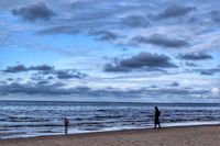
 Narva-Jõesuu beach Narva-Jõesuu beach
Pine forest along the coast | ||

Rationale
- Why do you think this case is relevant? What is your hypothesis considering the landscape challenges?
- Format: 3-4 sentences
Location and scope
You can edit this map with the map editor
A Landscape System Analysis
A.1 Landscape layers and their system context
Geomorphology, landscape units and coastal typology
- Description of evolution, status quo and driving forces, is the coastal typology changing? Why is that? (approx 200 signs)
It is located on the country's northern Baltic coast and the Gulf of Finland.
The settlement arose around the 14th century, It was the site of an outer harbour of the City of Narva from the 16th century, containing several timber stockyards, sawmills, and a small shipbuilding industry. Narva is a melting pot of Estonian and Russian cultures and a great place to stop and relax when travelling to and from St. Petersburg. The first spa in Narva-Jõesuu was opened in the 19th century, beginning a fine and well established tradition. Once a prime example of Baroque architecture in Europe, the town was heavily damaged in the Second war and almost entirely rebuilt. In the last few years its resort facilities have been renovated and thanks to its eight-kilometre-long white sand beach lined with pine tres, Narva-Jõesuu has become a popular summer destination.
- add 1-2 graphical representations to the image gallery, you can add more if you like
-
add a caption
-
add a caption
Land use
- settlements, infrastructure, agriculture, resource extraction, natural areas, energy production...
The settlement arose around the 14th century, It was the site of an outer harbour of the City of Narva from the 16th century, containing several timber stockyards, sawmills, and a small shipbuilding industry. Narva is a melting pot of Estonian and Russian cultures and a great place to stop and relax when travelling to and from St. Petersburg. The first spa in Narva-Jõesuu was opened in the 19th century, beginning a fine and well established tradition. Once a prime example of Baroque architecture in Europe, the town was heavily damaged in the Second war and almost entirely rebuilt. In the last few years its resort facilities have been renovated and thanks to its eight-kilometre-long white sand beach lined with pine tres, Narva-Jõesuu has become a popular summer destination.
- description of evolution, status quo and driving forces, is the land use likely to change? Why is that? (approx 200 signs)
- add 1-2 graphical representations to the image gallery, you can add more if you like
-
add a caption
-
add a caption
-
add a caption
Green/blue infrastructure
- What are the major potential elements of a green/blue infrastructure network? Are these likely to change/disappear? Why is that?
- You find my background material on green infrastructure in our reading list
- add 1-2 graphical representations to the image gallery, you can add more if you like
-
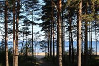 Pine forest along along the coast
 -
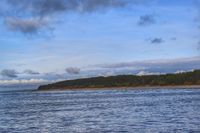
 Narva Bay


Actors and stakeholders
- Who is driving changes in this landscape? Who is affected by those changes?
- Draw a stakeholder and/or power map: Who is affected highly but with low power? Who has high power but is not affected?
-
add a caption
Sacred spaces and heritage
- Which places/elements hold cultural value and to whom?
- You may add a map and some images, please also explain in your caption why these elements are valuable
-
add a caption
-
add a caption
-
add a caption
Visual appearance and landscape narrative
- Which elements are essential for the landscape character?
- Has the landscape been painted or otherwise depicted, when and whom? Which elements are essential?
- Which narratives exist? Who has written about this landscape or depicted it in some way?
- You can add text and images
-
 Pine forest along the coastal
 -
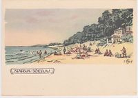 Postcard from 1960.
 -
add a caption

A.2 Summary of you landscape system analysis and your development Targets
- You can summarize your findings with an DPSI(R) Model or a Spider Diagram
- Link back to the Sustainable Development Goals: Which goals are at risk?
- What is your hypothesis for this landscape?
- Visualise your hypothesis with one graphic/pict
- Are there any existing initiatives taking action in this landscape? Do you have a critical perspective on that?
- Add text and visuals
-
explain your analysis briefly in the caption
-
explain your hypthesis briefly in the caption
A.3 Theory reflection
- Reflect on at least three international policy documents in relation to their local landscape case
- choose one international, one European and one national document
- You can choose references from our reading list
- Scope: 250 words
A.4 References
- give a full list of the references you have used for this section
Phase B: Landscape Evaluation and Assessment
B.1 Assessment Strategy
- Based on the hypothesis derived from your previous landscape systems analysis you are now asked to define the goals for assessing the landscape. Your assessment is the basis for evaluating the landscape status.
- Which elements and phenomena need to be mapped, why and how?
- This a text contribution, max 250 words
B.2 Mapping
- As defined by your assessment strategy you conduct the mapping and present your findings here
- As a minimum, at least three different themes need to be mapped, you may choose more if needed
-
briefly explain the findings of your mapping
-
briefly explain the findings of your mapping
-
briefly explain the findings of your mapping
B.3 Problem definition and priority setting
- Give a summary of the major findings of your mapping process, what are the problems/potentials identified?
- Draw a problems/potentials map
- Set priorities for the most relevant issues
-
add caption here
B.4 Theory reflection
- Please reflect the assessment and evaluation methods used based on at least three readings
- Did you encounter limitations'
- 200 words test contribution
B.5 References
- give a full list of the references you have used for this section
Phase C – Strategy and Master Plan
C.1 Goal Setting
- Define strategic planning objectives based on the evaluation findings
- Link back to your original targets from section one and the Development Goals
- 150 words text contribution
C.2 Spatial Strategy and Transect
- translate your strategic goals into a vision
- develop a spatial translation of your vision
- exemplify your vision in the form of a transect with concrete interventions
- add map(s) and visualizations
-
add caption here
-
add caption here
-
add caption here
-
add caption here
C.3 From Theory of Change to Implementation
- For implementing your vision: Which partnerships are needed? Which governance model is required?
- Who needs to act and how? Draw and explain a change/process model/timeline
- Which resources are needed? On which assets can you build?
- add 150 words text and visuals
-
add caption here
-
add caption here
C.4 References
- give a full list of the references you have used for this section
D. Process Reflection
- Reflect in your intercultural and interdisciplinary team on the outcomes of your study
- Which limitations were you facing?
- What have you learnt from each other?
- What would you do differently next time?
- You can also use diagrams/visuals
- 250 words text