Averno and Lucrino Lakes-Pozzuoli Coast: Difference between revisions
| Line 123: | Line 123: | ||
== A.3 Theory reflection == | == A.3 Theory reflection == | ||
'' | |||
According to Agenda 2030 there are a lot of possibilities on Pozzuoli’s area, with Goal 9 we choose to invest in resilient infrastructure promoting sustainable industrialization and innovative technologies for development. By 2030 we hope to raise industry’s sector, fishmarket and tourism focusing on affordable access for all. | |||
The Goal 11 take care of protection and safeguard of natural heritage and world’s cultural. We want to provide public transport, safe roads, green and public spaces for every range of people (from children to disable). Suppurt the resilient buildings with local materials and improve the sea financial (port, market, restaurant, artisanal fishers) for tourism according to regional development planning. | |||
Last but non least, the Goal 14 is crucial for the sea’s environment and marine resources. Water, weather, climate, coastlines are important for a growth of a city that face to the sea. | |||
By 2020 regulate the overfishing and illegal fishing practices [Averno Lake was confiscated by police in 2010 because of mafia infiltration] , reduce pollution and increasing use of marine resources, acquaculture and biodiversity. | |||
The Marine Directive 2008 is the first EU legislative instrument related to the protection of marine biodiversity till 2020 and to the resource base upon which marine-related economic and social activities depend. Climate change can reduce the ‘ecosystem resilience’, impacts include rising sea levels, increased sea temperatures, precipitation changes, and ocean acidification. | |||
Regarding the Italian treaties, we decided to consider for the delicate area of Pozzuoli the Ecomafia 2009 report by Legambiente which establishes the protection and safeguard of the environment, related to the waste emergency. Applied tricks, racket of animals, archeomafia, agromafia, forest fire (like Vesuvius'fire in 2017) are topics on the agenda for the Campania region, the data speak of 71 ecoreati a day, without count the illegal buildings. We know that with sensibilization we can change people's mind: that's our goal. | |||
'' | |||
== A.4 References == | == A.4 References == | ||
Revision as of 12:06, 19 April 2018
>>>back to working groups overview
| Area | Averno and Lucrino Lakes | |
| Place | Pozzuoli, Naples | |
| Country | Italy | |
| Topics | Heritage, Turism & Landscape in Pozzuoli Coast | |
| Author(s) | Vassallo Martina © - Errichiello Raffaele - Iossa Pasquale - Marandino Federica | |

| ||
Rationale
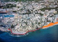
Pozzuoli is one of the most relevant site in Naples metropolitan area. The Coast is rich of assets of cultural interest, starting from the old Roman military port nearby Averno and Lucrino Lakes (full of monuments, temples and archeological sites), continuing to Monte Nuovo and Astroni Park (where is located the famous Solfatara), till the new area recently built and still in requalification phase of Rione Terra. This quarter extended to the dock of Puteoli (ancient name of Pozzuoli) is developing as a new economic and touristic source; this changes are reflected in other parts of the city like industries and beaches increasingly crowded. Our priority is to include the coastal landscape into a urban resilience that provide green and blu infrastructure.
Location and scope
You can edit this map with the map editor
A Landscape System Analysis
A.1 Landscape layers and their system context
Geomorphology, landscape units and coastal typology
Pozzuoli is located on the homonymous gulf in a volcanic area, the Campi Flegrei, which includes a still active volcano, the Solfatara. The territory is mostly hilly, including several volcanic craters including the Astroni, Monte Nuovo and the one that houses Lake Averno. From this area the ground falls quite steeply thru the sea. Typical of this city and the entire area of the Campi Flegrei is the geothermal phenomena called bradyseism, which is the raising and lowering of the earth's crust as a result of the increase in underground pressure. The rapid rise in sea level generated by this phemomena involved the coastal area and the port, which was repositioned about 50 meters after than the previous location.
-
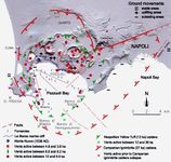 Analysis weathering from INGV Vesuvian Observatory
 -
 Progress of the coast after bradyseism phenomenon in 1980
 -
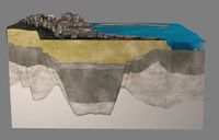 Study of subsoil, photo from Science Magazine, 7th August 2015
 -
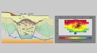 Study of subsoil, photo from Science Magazine, 7th August 2015


Land use
Pozzuoli, at the time named Dicearchia, was inhabited since 531 a.C. as greek colony under dependency of Cuma. In 338 a.C. all the Campania region was occupied by Romans, who gave to their key maritime colony the new latin name Puteoli which means small wells, due to the numerous springs of thermo-mineral waters found there. Since the first settlements the population increased and Pozzuoli became the point of convergence of rural, urban and industrial areas. In the city there was a flourishing industrial activity developed along the road Via Fasano that connects the center with the urban settlement of Arco Felice. The first industry was the British Armstrong. Between the two World Wars Pozzuoli was one of the most important industrial pole for the armament of battleships. During 1957 the industry has been trasformed into mechanical enstablishment “Aerfer” and after 10 years incorporated by railways workshops “Sofer” (one year later, in 1968 becamed consortium “Inbus”). In 2003 the factories were closed after 100 years of activity. Now there’s a project of redevelopment for a sailing center. Olivetti enstablishment was built in 1955 by Luigi Cosenza. The singularity of the building is an exemplary integration in the natural panorama of the Neapolitan coast and the nearby residential district form a unique space in the area. The Law 64/1986 allowed a restructuring plan for the Olivetti Research Centre, now the enstablishment has a new role with new laboratories for new office’s activities. The industrial area is going to be redeveloped through the improvement of roads and sea trasports, at the moment the influx of people is focused on maritimes link to the islands and on the fishmarket that is growing faster (is the 3th one more important in Italy). Lucrino Lake take is name from latin word "Lucrum" (that means earning, profit) because of the fish farms and oysters (senator Sergio Orata became one of the richest man in that age). The city remains in contact with Napoli and the suburban aereas nearby trought 3 reailways, one subway and the Cumana and Circuflegrea lines.
-
add a caption
-
add a caption
-
add a caption
Green/blue infrastructure
- What are the major potential elements of a green/blue infrastructure network? Are these likely to change/disappear? Why is that?
- You find my background material on green infrastructure in our reading list
- add 1-2 graphical representations to the image gallery, you can add more if you like
-
add a caption
-
add a caption
Actors and stakeholders
- Who is driving changes in this landscape? Who is affected by those changes?
- Draw a stakeholder and/or power map: Who is affected highly but with low power? Who has high power but is not affected?
-
add a caption
Sacred spaces and heritage
- Which places/elements hold cultural value and to whom?
- You may add a map and some images, please also explain in your caption why these elements are valuable
-
add a caption
-
add a caption
-
add a caption
Visual appearance and landscape narrative
- Which elements are essential for the landscape character?
- Has the landscape been painted or otherwise depicted, when and whom? Which elements are essential?
- Which narratives exist? Who has written about this landscape or depicted it in some way?
- You can add text and images
-
add a caption
-
add a caption
-
add a caption
A.2 Summary of you landscape system analysis and your development Targets
- You can summarize your findings with an DPSI(R) Model or a Spider Diagram
- Link back to the Sustainable Development Goals: Which goals are at risk?
- What is your hypothesis for this landscape?
- Visualise your hypothesis with one graphic/pict
- Are there any existing initiatives taking action in this landscape? Do you have a critical perspective on that?
- Add text and visuals
-
explain your analysis briefly in the caption
-
explain your hypthesis briefly in the caption
A.3 Theory reflection
According to Agenda 2030 there are a lot of possibilities on Pozzuoli’s area, with Goal 9 we choose to invest in resilient infrastructure promoting sustainable industrialization and innovative technologies for development. By 2030 we hope to raise industry’s sector, fishmarket and tourism focusing on affordable access for all. The Goal 11 take care of protection and safeguard of natural heritage and world’s cultural. We want to provide public transport, safe roads, green and public spaces for every range of people (from children to disable). Suppurt the resilient buildings with local materials and improve the sea financial (port, market, restaurant, artisanal fishers) for tourism according to regional development planning. Last but non least, the Goal 14 is crucial for the sea’s environment and marine resources. Water, weather, climate, coastlines are important for a growth of a city that face to the sea. By 2020 regulate the overfishing and illegal fishing practices [Averno Lake was confiscated by police in 2010 because of mafia infiltration] , reduce pollution and increasing use of marine resources, acquaculture and biodiversity. The Marine Directive 2008 is the first EU legislative instrument related to the protection of marine biodiversity till 2020 and to the resource base upon which marine-related economic and social activities depend. Climate change can reduce the ‘ecosystem resilience’, impacts include rising sea levels, increased sea temperatures, precipitation changes, and ocean acidification.
Regarding the Italian treaties, we decided to consider for the delicate area of Pozzuoli the Ecomafia 2009 report by Legambiente which establishes the protection and safeguard of the environment, related to the waste emergency. Applied tricks, racket of animals, archeomafia, agromafia, forest fire (like Vesuvius'fire in 2017) are topics on the agenda for the Campania region, the data speak of 71 ecoreati a day, without count the illegal buildings. We know that with sensibilization we can change people's mind: that's our goal.
A.4 References
- give a full list of the references you have used for this section
Phase B: Landscape Evaluation and Assessment
B.1 Assessment Strategy
- Based on the hypothesis derived from your previous landscape systems analysis you are now asked to define the goals for assessing the landscape. Your assessment is the basis for evaluating the landscape status.
- Which elements and phenomena need to be mapped, why and how?
- This a text contribution, max 250 words
B.2 Mapping
- As defined by your assessment strategy you conduct the mapping and present your findings here
- As a minimum, at least three different themes need to be mapped, you may choose more if needed
-
briefly explain the findings of your mapping
-
briefly explain the findings of your mapping
-
briefly explain the findings of your mapping
B.3 Problem definition and priority setting
- Give a summary of the major findings of your mapping process, what are the problems/potentials identified?
- Draw a problems/potentials map
- Set priorities for the most relevant issues
-
add caption here
B.4 Theory reflection
- Please reflect the assessment and evaluation methods used based on at least three readings
- Did you encounter limitations'
- 200 words test contribution
B.5 References
- give a full list of the references you have used for this section
Phase C – Strategy and Master Plan
C.1 Goal Setting
- Define strategic planning objectives based on the evaluation findings
- Link back to your original targets from section one and the Development Goals
- 150 words text contribution
C.2 Spatial Strategy and Transect
- translate your strategic goals into a vision
- develop a spatial translation of your vision
- exemplify your vision in the form of a transect with concrete interventions
- add map(s) and visualizations
-
add caption here
-
add caption here
-
add caption here
-
add caption here
C.3 From Theory of Change to Implementation
- For implementing your vision: Which partnerships are needed? Which governance model is required?
- Who needs to act and how? Draw and explain a change/process model/timeline
- Which resources are needed? On which assets can you build?
- add 150 words text and visuals
-
add caption here
-
add caption here
C.4 References
- give a full list of the references you have used for this section
D. Process Reflection
- Reflect in your intercultural and interdisciplinary team on the outcomes of your study
- Which limitations were you facing?
- What have you learnt from each other?
- What would you do differently next time?
- You can also use diagrams/visuals
- 250 words text