Peipsi Lake from Kallaste Southwards: Difference between revisions
| Line 59: | Line 59: | ||
=== Green/blue infrastructure === | === Green/blue infrastructure === | ||
''The major potential elements of a green/blue infrastructure network are: | ''The major potential elements of a green/blue infrastructure network are: | ||
*Wetlands with reeds and bulrush | |||
*Alatskivi Landscape Reserve | |||
*Alastkivi Park | |||
*Lake Peipsi watershed (Emajõe Suursoo and Remedovsky) | *Lake Peipsi watershed (Emajõe Suursoo and Remedovsky) | ||
*Lake Alatskivi | *Lake Alatskivi | ||
*Lake Lahepera | *Lake Lahepera | ||
*Watershed of Narva River (77km) | *Watershed of Narva River (77km) | ||
Due to the increased load of nutrients caused by human activities, eutrophication, caused by the high nutrient load, is a major threat to water quality in the lake. | Due to the increased load of nutrients caused by human activities, eutrophication, caused by the high nutrient load, is a major threat to water quality in the lake. | ||
| Line 86: | Line 87: | ||
File:Wetland.JPG|''Wetland with reeds and bulrush by Triin Olvet'' | File:Wetland.JPG|''Wetland with reeds and bulrush by Triin Olvet'' | ||
File:Natura2000map.jpg|''Natura 2000 information map of Peipsi Lake. Base map source: http://natura2000.eea.europa.eu/'' | File:Natura2000map.jpg|''Natura 2000 information map of Peipsi Lake. Base map source: http://natura2000.eea.europa.eu/'' | ||
File:Green infra map.jpg|''Green infrastructure map. Alatskivi Landscape Reserve photo by Sergei Gussev. | |||
File:Blue infra map.jpg |''Blue infrastructure map. Lake Alatskivi photo by Kristjan Lust. Lake Lahepera photo by Mmh. Lake Peipsi photo by Silvana Gallone. '' | File:Blue infra map.jpg |''Blue infrastructure map. Lake Alatskivi photo by Kristjan Lust. Lake Lahepera photo by Mmh. Lake Peipsi photo by Silvana Gallone. '' | ||
</gallery> | </gallery> | ||
Revision as of 12:45, 19 April 2018
>>>back to working groups overview
| Area | Peipsi Lake | |
| Place | Kallaste Southwards | |
| Country | Estonia | |
| Topics | Sand stone coast: folklore culture, agriculture and tourism | |

| ||
Rationale
Since the 18th century, the old Russian Orthodox belivers use to live on the Estonian side of the lake, which is the 5th largest in Europe. Along the coast, which is the longest sandstone coast in Estonia, it is possible to find at least 11 outcrops whose highest is proctected since 1959. This is why it is important to keep the cultural heritage and the unique landscape, which made out of this place, a touristic spot. Moreover, the lake is an important ressource of fishies and the water management is really important in these regions where the land use to be big arable aareas in both Estonian and Russian side, which caused eutrophication of the water.
Location and scope
You can edit this map with the map editor
A Landscape System Analysis
A.1 Landscape layers and their system context
Geomorphology, landscape units and coastal typology
Coastal area of Peipsi is flat. Geological substructure is devonian era sedimentary rock of Aruküla Stage (350 mln years old). In the late ice-age and at the beginning of Holocene, the current lowland was under the water. Sedimentary rock is covered with glacial and post-glacial lake sediments (sand, clay, organical sediments).
-
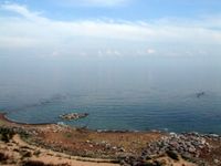 Lake Peipsi shore by Elvis Kõll
 -
 Peipsi lake at Kallaste by Laima Gūtmane


Land use
During the Soviet time, the fisherman and the farmers around Peipsi lake use to sell their production along the Hansa traiding organization ways, from the middle age. Since 1992, the borders make it hard for traders. Around the lake, the land use to be arable in both sides, but the new intensives agricultural technologies and chemical created eutrophication phenomenon in the water of the lake, especially because of the forest cuts, the trees can not absorb the chemicals anymore. However, the economics problems of Russia and Estonia made fishing decrease. Considering the lake as one of biggest fish stock in Estonia with 33 different species, the fish reserve is nowadays under-exploited.
-
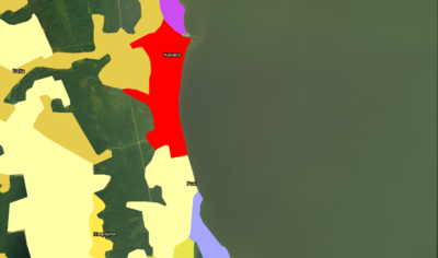 Land use map of Kallaste (Red : constructed part / Orange and Yellow : agricultural parts / Purple : Wetlands and water / Pink : industries / Green : forests / Dark green : Peipsi lake)
 -
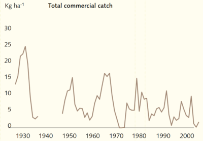 Amount of commercial fish catches in Peipsi lake


Green/blue infrastructure
The major potential elements of a green/blue infrastructure network are:
- Wetlands with reeds and bulrush
- Alatskivi Landscape Reserve
- Alastkivi Park
- Lake Peipsi watershed (Emajõe Suursoo and Remedovsky)
- Lake Alatskivi
- Lake Lahepera
- Watershed of Narva River (77km)
Due to the increased load of nutrients caused by human activities, eutrophication, caused by the high nutrient load, is a major threat to water quality in the lake.
Lake Peipsi receives pollution mainly from two sources: river water and precipitation directly into the lake. The nutrient content in the rivers of Lake Peipsi basin was high at the end of the 1980s, causing eutrophication of water bodies.
The wastewaters and gaseous emission of toxic sulphur and nitrogen oxides, hydrogen chlorine and carcinogenic compounds from power stations operating on pulverized oil shale have a considerable impact on the chemical composition of water in Lake Peipsi.
As one travels from south to north the content of total nitrogen decreases, while water transparency increases. The first trend is caused by the impact of the pollution loads from big cities like Pskov and Tartu, the second by the sediment pumped from the mines when it finally reaches the lake.
Also large-scale expansion of reeds has taken place. The intensive agricultural activities caused eutrophication to accelerate in the lakes and rivers.
Despite the drop in mineral fertilizer use during the last 10 years and a decrease in the number of domestic animals in the Lake Peipsi watershed, the impact of the earlier agricultural pollution is still significant.
The pollutants that were discharged into the lake remain in the lake bottom sediments for years (Roll & Abercrombie 1997). Cuts of forest in the watershed have resulted in considerable increases in the discharge of dissolved and solid phosphorus, nitrogen and potassium in run-off waters that flow into Lake Peipsi.
-
 Wetland with reeds and bulrush by Triin Olvet
 -
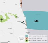 Natura 2000 information map of Peipsi Lake. Base map source: http://natura2000.eea.europa.eu/
 -
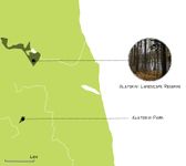 Green infrastructure map. Alatskivi Landscape Reserve photo by Sergei Gussev.
 -
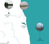 Blue infrastructure map. Lake Alatskivi photo by Kristjan Lust. Lake Lahepera photo by Mmh. Lake Peipsi photo by Silvana Gallone.


Actors and stakeholders
- Who is driving changes in this landscape? Who is affected by those changes?
- Draw a stakeholder and/or power map: Who is affected highly but with low power? Who has high power but is not affected?
-
add a caption
Sacred spaces and heritage
Fishing is one of the most important activities around the lake. Fisherman can get money from the fishies they sell in summer, this lake is one of the biggest stock of fishes in Europe (33 spices) combining arctic and warm water fishies. But fisherman can also during winter. Indeed, they developped special machines (Karakatista machines) to go fishing on the ice and organize some touristic trips to show their knowledges. All the products from fishing but also from agriculture are sold since the Middle Age, traveling along the Hansa traiding organisation roads.
It is one of the cleanest in Europe and with a considerable potential for recreation. And every year, tourists come on the lake coasts to enjoy the typical landscape. But tourists are also attracted by the cultural heritage from the Soviet time and use to visit churches, from the old Russian belivers, really presents in the area.
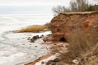
The Kallaste beach is also a really cultural point in the area. Indeed, the outcrops, the cliffs and the sand-stone attract every year a lot of tourists. It is also nature, and a spot especially considered as favorable for recreation. It is then really important to keep this special landscape, because tourism, even if it is only seasonality, is a big part of Kallaste economic activity. A lot of Kallaste inhabitants have a buisness with small and private B&B (Bed and breakfast) to host and feed tourists, and this lanscape is typical from the area, is has to be protected for the diversity ans the heritage.
-
 Map of the heritage points location

-
 Karakatista machines, created by the Peipsi lake fishermen
 -
 Old Russian beliver's Church : Vanausulised
 -
 Typical coastal touristic landscape


Visual appearance and landscape narrative
Which elements are essential for the landscape character?
- The lake is known for the existence of large wetlands in the surroundings (Carp 1980, Commission of the European Communities 1995).
- Forests and semi-natural areas dominate in the Peipsi basin.
- Agricultural areas cover around 14%.
- Wetlands, although scattering the entire basin, are located in a relatively large portion near the shore of the lake.
- Shallow lake (maximum 15 m, average of 7m).
- The shoreline of 875 km is a natural one; there are no dikes or embankments along the shore.
- Forests cover large areas in the basin, In the northern area and eastern shores they make up to 60-70% of the surface area, while in the southern and western shores it is 30-40%. Mires and bogs cover up to 10% of the catchment area and another 15-20% are wetlands, such as wet meadows and forests. Large parts of arable land are to be found in the western and southern part of the basin.
Lake Peipsi has been a true source of inspiration over the decades, example of this is the famous painting made by Serov, Vladimir Alxandrovich called "Battle on the Ice". This famous painting tells the story about a notable battle that took place on April 5th of 1242, fought largely on the frozen lake, establishing the frontier between the East and West.
-
 Serov, Vladimir Alxandrovich (1942), "Battle on the Ice"
 -
 Von Klever, Julius Sergius (1908), "Winter at Lake Peipus"
 -
 Uiga, Johannes (1947), "View to lake Peipsi from Alatskivi"

_klever.jpg)

A.2 Summary of you landscape system analysis and your development Targets
- You can summarize your findings with an DPSI(R) Model or a Spider Diagram
- Link back to the Sustainable Development Goals: Which goals are at risk?
-
 Scheme of the elements who influence Peipsi lake environnement and their relations

We actually consider that the activities with the biggest impacts are fishing, agricultural, tourism. Indeed, the climate is a natural state of the region over Peipsi lake, which is changing more because of the global human activities than because of the local Kallaste’s.
Regarding the fishing activities, as it is the biggest one in the area, the problem will be soon the decrease of the fish population. Meaning that the big stock of fishes and the huge species diversity will disappear. So Peipsi lake will be empty from fishes and it will not be possible to fish anymore. Furthermore, the population living with fishes will leave the area to find another way to survive, meaning that the human population will decrease, as the fish’s one.
But the fishes are also in danger regarding the agriculture. Indeed, the new techniques to over cultivate, with machines and chemicals are creating eutrophication. The extra phosphorus added in the fields will run to the lake through the water, which will over developed the sea weeds, stopping the oxygen. Then no more oxygen in the water means no fishes anymore.
The last important point is the tourism, even if it exists two different scenarios. The first one is that the landscape is getting less and less interesting due to the decrease of fish population and so on on the small economic activities. Then the tourists will just stop to go on the Peipsi lake coasts, reducing more and more the economic activities. On the the other hand, the tourists keep coming and coming, making the seasonality effect bigger and bigger with the risk of a bad waste management, with a lot pollution (water, air due to the cars..) even if it can increase the economy.
When considering the Sustainable Development Goals, it becomes clear that the following goals may be at risk if the situation in Lake Peipsi remains the same:
- Goal 1: No Poverty - Low resources. Reason for rural exodus.
- Goal 2: Zero Hunger - Over fishing. Low fish stock.
- Goal 4: Quality Education - No education infrastructure but at the same time no demand due to the goal 1 failure.
- Goal 8: Decent Work and Economic Growth - No diversity on economic activities (mostly fishing and agriculture).
- Goal 14: Life Below Water - Threatened by the economic activities of fishing and agriculture, as explained before.
-
 Scheme of the main activities in Kallaste area and impact they can have if there is no action against it

- Are there any existing initiatives taking action in this landscape? Do you have a critical perspective on that?
- Add text and visuals
A.3 Theory reflection
- Reflect on at least three international policy documents in relation to their local landscape case
- choose one international, one European and one national document
- You can choose references from our reading list
- Scope: 250 words
A.4 References
- https://www.visitestonia.com/en/kallaste-old-believers-prayer-house-of-the-estonian-association-of-old-believers-congregations
- https://tartu.postimees.ee/3852591/uued-tuuled-kallaste-sadamas-koik-ei-mahu-enam-marjamaale
- Google earth
- https://www.visitestonia.com/en/kallaste-outcrop
Phase B: Landscape Evaluation and Assessment
B.1 Assessment Strategy
- Based on the hypothesis derived from your previous landscape systems analysis you are now asked to define the goals for assessing the landscape. Your assessment is the basis for evaluating the landscape status.
- Which elements and phenomena need to be mapped, why and how?
- This a text contribution, max 250 words
B.2 Mapping
- As defined by your assessment strategy you conduct the mapping and present your findings here
- As a minimum, at least three different themes need to be mapped, you may choose more if needed
-
briefly explain the findings of your mapping
-
briefly explain the findings of your mapping
-
briefly explain the findings of your mapping
B.3 Problem definition and priority setting
- Give a summary of the major findings of your mapping process, what are the problems/potentials identified?
- Draw a problems/potentials map
- Set priorities for the most relevant issues
-
add caption here
B.4 Theory reflection
- Please reflect the assessment and evaluation methods used based on at least three readings
- Did you encounter limitations'
- 200 words test contribution
B.5 References
- give a full list of the references you have used for this section
Phase C – Strategy and Master Plan
C.1 Goal Setting
- Define strategic planning objectives based on the evaluation findings
- Link back to your original targets from section one and the Development Goals
- 150 words text contribution
C.2 Spatial Strategy and Transect
- translate your strategic goals into a vision
- develop a spatial translation of your vision
- exemplify your vision in the form of a transect with concrete interventions
- add map(s) and visualizations
-
add caption here
-
add caption here
-
add caption here
-
add caption here
C.3 From Theory of Change to Implementation
- For implementing your vision: Which partnerships are needed? Which governance model is required?
- Who needs to act and how? Draw and explain a change/process model/timeline
- Which resources are needed? On which assets can you build?
- add 150 words text and visuals
-
add caption here
-
add caption here
C.4 References
- give a full list of the references you have used for this section
D. Process Reflection
- Reflect in your intercultural and interdisciplinary team on the outcomes of your study
- Which limitations were you facing?
- What have you learnt from each other?
- What would you do differently next time?
- You can also use diagrams/visuals
- 250 words text