Giant's Causeway: Difference between revisions
No edit summary |
|||
| Line 47: | Line 47: | ||
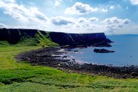
Generally one can say that it is a rock coast. | Generally one can say that it is a rock coast. | ||
<gallery caption=" " widths=" | <gallery caption=" " widths="250px" heights="200px" perrow="5"> | ||
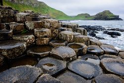
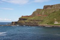
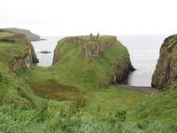
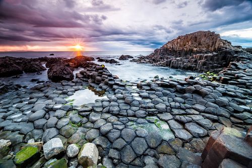
File:Coast typology Giant's Causeway.jpg|''rock formation on Giant's Causeway'' | File:Coast typology Giant's Causeway.jpg|''rock formation on Giant's Causeway'' | ||
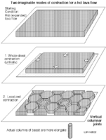
File:Formation of basalt columns.png|''The formation of basalt columns'' | File:Formation of basalt columns.png|''The formation of basalt columns'' | ||
Revision as of 10:16, 23 May 2018
>>>back to working groups overview
| Area | Giant's Causeway | |
| Place | Antrim | |
| Country | Northern Ireland | |
| Topics | Heritage and Nature protection | |
| Author(s) | Melanie Schnürer | |
| ||
Rationale
The Giant's Causeway is located in Northern Ireland, in the Country Antrim. If you visit Northern Ireland, you must visit the World Heritage Site "Giant's Causeway", which was added to the UNESCO World Heritage List in 1986. In addition, the Giant's Causeway is a tourist interesting and worth seeing element. It is the only World Heritage Site in Northern Ireland and is one of Northern Ireland's most popular attractions. It is important that the more than 60 million years old rock formation is further protected.
Location and scope
You can edit this map with the map editor
A Landscape System Analysis
A.1 Landscape layers and their system context
Geomorphology, landscape units and coastal typology
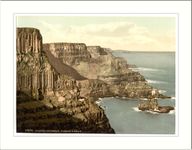
The rock formations with more than 40,000 individual, black basalt columns are interconnected and predominantly hexagonal in shape. But there are also basalt columns that are quadrangular, pentagonal, heptagonal and octagonal. The Giant's Causeway is about 5 km long and leads along the cliffs into the sea. Some of the basalt columns have a height of about 12 meters and the rock layer is about 25 meters thick.
The formation of the basalt columns is due to the cooling of hot lava. The volcano that was responsible for this formation was eroded by erosion. Generally one can say that it is a rock coast.
Land use
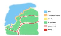
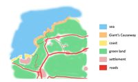
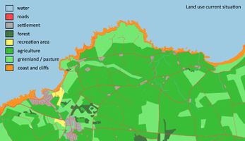
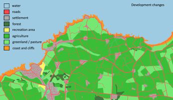
Giant's Causeway is located on the Atlantic Ocean in the Country Antrim on the northern coast of Northern Ireland. The settlement of Bushmills lies west of the Giant's Causeway and is the closest village. A big city, which is about 80 km away, is Belfast.
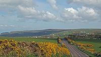
To get to the Giant's Causeway, the small trails can be used. However, the best way to get to the attraction is to take a walk along the cliffs or over the hills. The main roads can be found at some distance. The green areas, especially grass areas dominate the surroundings.
In the past, the adjacent cities were smaller and the green areas were larger. The expansion of the trails was not as good as it is today.
As it is a UNESCO World Heritage, the extraction of raw materials and energy in the immediate area is not allowed.
Green/blue infrastructure
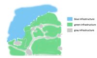
Both blue and green infrastructures exist on this area. These green and blue infrastructures are today important indicators of biodiversity conservation, as well as the strengthening and regeneration capacity of ecosystem functions. The aim is a sustainable use of nature. This green and blue infrastructure contrasts with the gray infrastructure. The concept of green and blue infrastructure has a huge impact on the future and is strongly promoted, including by the EU.
In order to improve the green and blue infrastructure, sealing through the gray infrastructure must be avoided. In addition, you can develop green and blue infrastructure, for example, if nature pieces are renatured again. Another possibility would be to turn Gray Infrastructure back into green and blue infrastructures.
Here you will find the following green infrastructures:
- Agriculture (in Northern Ireland total 74%)
- grasslands
- open fields
- forest areas (at some distance) (in Northern Ireland total 8%)
and the following blue infrastructures:
- sea
- some bays
When it comes to Ireland's landscapes, you hear again and again the phrase '40 Shades of Green '. Ireland is VERY green.
Actors and stakeholders
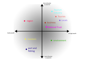
The landscape is changed by important actors. The actor who has the most influence in this landscape is the tourist. Every year, over 750,000 people visit the Giant's Causeway. Another major actor is the National Trust, which acquired Giant's Causeway in 1961 and has since been responsible for protecting and preserving the site.
Other actors include the tourist industry, businesses and local people who benefit from the Giant's Causeway, whether through rentals to tourists or through the sheltered spot for their own health.
Likewise, the region has an impact on the site, but does not benefit primarily from the Giant's Causeway. The region has other unique locations besides the Giant's Causeway, from which it benefits.
Actors who are not particularly influential on the Giant's Causeway are investors and the port and the fishery. Also, they do not benefit from the place. They do not benefit from the location, as there is a harbor some distance away (in the next village) and fishery is hardly possible due to its status as a World Heritage Site and it is not allowed. Investors have no opportunity to invest in something here.
The environment also has little impact, but it benefits from the Giant's Causeway as it represents a unique and special biotope. This biotope is home to animals and plants.
Sacred spaces and heritage
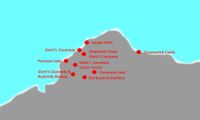
The Giant's Causeway is itself a World Heritage because it is unique and very old (over 60 million years). It has a cultural value for the entire population, since this rock formation occurs only in certain places and is very rare to observe worldwide. There are also some special places within the Giant's Causeway that are as unique as they are intriguing. These include Portcoon Jetty and Lacada Point.
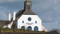
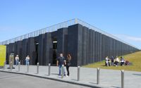
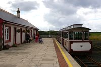
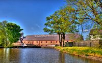
In the wider area, in Bushmills, you will find some important places that are valuable. In Bushmills there is the "Giant's Causeway and Bushmills Railway". The Railway is a narrow gauge heritage railway operating between the Giant's Causeway and Bushmills. The line is about 3 km long. Also located in Bushmills is the "Old Bushmills Distillery", the most famous whiskey distillery in the world. The Giant's Causeway Visitor Centre is also located in the vicinity and is an information center for the Giant's Causeway.
Other highlights include the Causeway head, the shepherd's steps Giant's Causeway and the Dunseverick castle.
Visual appearance and landscape narrative
There are different forms of presentation. There are countless different postcards available at the Giant's Causeway Visitor Centre, but can also be found as souvenirs in other stores. These postcards may be elements of the former Giant's Causeway, but there are also postcards showing the current situation.
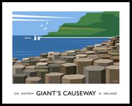
Some famous paintings were also painted. A special picture was painted by Scott Naismith, who has painted the picture with special colors. Another picture painted by James Kelly, which stands out for its simplicity.
The most significant narrative are the photos that visitors of the Giant's Causeway make, as it allows everyone to tell their own story.
Known is the legend told about the Giant's Causeway. Learn about the history and myths of the UNESCO World Heritage Site at Giant's Causeway Visitor Centre. The star of the story is Fionn mac Cumhaill (Finn McCool) - an Irish giant who fought a dispute with the Scottish heavyweight Benandonner. Legend has it that the giants hated each other. So it happened that one day, after constant insults from Benandonner, Fionn built a trail of stepping stones from Ireland to Scotland. However, Benandonner destroyed this way shortly thereafter. The result is the Giant's Causeway!!
A.2 Summary of you landscape system analysis and your development Targets
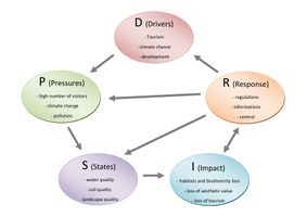
The DPSI (R) model shows the Driving Forces, Pressures, States, Impacts and Responses to be found at the site.
Drivers in this case are tourism, climate change and developments. Developments could be, for example, land development or demographic developments. Due to demographic change, cities will continue to grow, which will then lead to land development. The cities have to spread and grassland has to disappear.
Pressures are the growing number of visitors, climate change and pollution. These pollutions are due to the growing number of visitors as they bring the garbage and do not take it home again. In addition, the environment is heavily used by the influence of these visitors.
States are the water quality, the quality of the soil and the quality of the landscape, as they suffer from pollution. The water, but also the soil suffer from the rubbish of the visitors. The quality of the landscape suffers because this place is unique and should not be polluted by pollution.
Impact is reflected in the loss of habitat and biodiversity of the place. In addition, the place loses aesthetics. When this impact takes place, it leads to a loss of tourism. This influence will then show in the ever-decreasing number of visitors and give no reason to visit this place.
Response can be to make regulations, but also to inform visitors and residents. Likewise, Giant's Causeway must be controlled to preserve and maintain World Heritage status.
These responses are already covered by the World Heritage status, but should always be checked again. Also, the National Trust is responsible for the protection.
The following sustainability goals are particularly at risk:
- Good health and well-being
- Quality education
- Clean water and sanitation
- Climate action
- Life below water
- Life on land
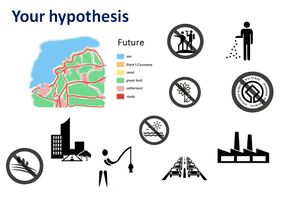
My hypothesis for this landscape is the following:
- Increase in gray infrastructure:
- Roads are being expanded
- Cities grow and enlarge
- Industry is growing in the immediate vicinity
- Traffic is increasing
- Decrease in green and blue infrastructure:
- Green areas shrink and are broken up
- Green areas are polluted
- Waters are polluted
- No more habitat for animals and plants
- Pollution of the environment
- Fishing is increasing
- In the worst case: destruction of the world cultural heritage
Generally, the quality of the place will decrease and the aesthetic value of the Giant's Causeway will also decrease. A unique phenomenon could not be preserved for posterity, thus destroying an ancient testimony of ancient times.
A.3 Theory reflection
Northern Ireland does not belong, as the name implies, to Ireland, but is a country and part of the United Kingdom of Great Britain and Northern Ireland. One of the most beautiful tourist destinations is the Giant's Causeway. It is away from major cities and is located in nature.
The sustainability goals of the United Nations show many aspects that can be transferred to the Giant's Causeway. There are some of these goals in this landscape: No poverty; Zero hunger; Good health and well-being; quality education; gender equality; clean water and sanitation; affordable and clean energy; climate action; life below water; life on land; peace, justice and strong institutions
In general, the other goals can also be found in some parts (decent work and economic growth; industry, innovation and infrastructure; reduced inequalities, sustainable cities and communities; responsible consumption; partnerships for the goals).
The European Landscape Convention describes what landscape is and how it is best identified and protected. These goals must be considered very strict for Giant's Causeway. Giant's Causeway is unique and must be protected.
Even the Department of the Environment has issued a policy document, which was issued in July 2013. The Planning Policy Statements and Supplementary Planning Guidance includes this document and is involved in the second point for planning and nature conservation.
These three documents show that it is very important for natural spaces to protect them. Since the Giant's Causeway is a World Heritage Site, there are very specific rules that must be followed.
A.4 References
- https://www.ireland.com/de-de/sehenswertes/giants-causeway/ (access on 16.04.2018)
- http://www.giantscausewayofficialguide.com/index.html#introduction (access on 16.04.2018)
- https://sites.google.com/site/geo327pam/p2 (access on 17.04.2018)
- https://www.primolo.de/node/31792 (access on 17.04.2018)
- https://de.wikivoyage.org/wiki/Nordirland (access on 18.04.2018)
- http://www.nordirland.info/natur/vegetation.html (access on 18.04.2018)
- http://www.pnp.de/nachrichten/ratgeber/reise_und_urlaub/reiseberichte/603704_Der-Giants-Causeway-in-Nordirland-Am-Anfang-der-Welt.html (access on 19.04.2018)
- https://giantscausewaytickets.com/geology-and-landscape (access on 19.04.2018)
Phase B: Landscape Evaluation and Assessment
B.1 Assessment Strategy
The landscape system analysis has shown different challenges. One of the biggest challenges is the constant growth of cities and infrastructures. This may result in elements of the Giant's Causeway being lost. It is important to maintain this World Heritage Site. Another problem is climate change, which destroys the unique formations and threatens wildlife.
The goals for the assessment of the landscape is to inspire people for the beauty of nature. It also aims to educate people on what climate change is doing, not just in Northern Ireland, but what they can do anywhere in the world. People should also be encouraged to work for climate protection.
These goals are relevant as climate change is a key issue in our times, affecting not only our generation, but also the next and future generations. Demographic change is further expanding cities and infrastructure, and increasing numbers of tourists are polluting places and impacting climate change.
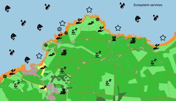
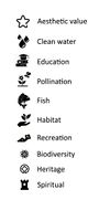
It is important to look at the ecosystem services in the area, as well as possible further development as cities continue to grow and infrastructure is expanded. Ecosystem services are an important factor when it comes to biodiversity.
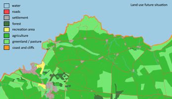
Growing cities and infrastructures are making the Giant's Causeway area and buffer area smaller and potentially losing World Heritage status.
Another element that needs to be mapped is the impact of climate change on the Giant's Causeway. Over the next few years, more and more columns will suffer and be flooded under rising sea levels. Likewise, the erosions will shrink the Giant's Causeway.
B.2 Mapping
In order to get a better picture I will apply three different methods of mapping.
In the first method I will look at the ecosystem services in the area. The second method is the potential impact of climate change and the third method is the evolution of cities and infrastructures.
B.3 Problem definition and priority setting
Giant's Causeway is threatened by many problems and risks, but there are also some potentials. Many ecosystem services are threatened by these problems. The most threatened are the coasts and the green areas. The rock formations of the Giant's Causeway are unique and very rare to see. The biggest problem is climate change. Followed by the destruction of the world cultural heritage, the loss of biodiversity and the rise of sea level and flooding. This is followed by the loss of habitats for animals, pollution, developmental changes and erosions.
Potentials include, for example, increased tourism, natural development, the construction of renewable energy, interest groups could increase and recreation.
B.4 Theory reflection
- Please reflect the assessment and evaluation methods used based on at least three readings
- Did you encounter limitations'
- 200 words test contribution
B.5 References
- https://www.irishtimes.com/news/managing-the-future-of-a-giant-s-legacy-1.1102970 (access on 15.05.2018)
- https://www.theguardian.com/environment/2008/jan/22/climatechange.water (access on 15.05.2018)
- http://news.bbc.co.uk/2/hi/uk_news/northern_ireland/7201501.stm (access on 15.05.2018)
- https://www.telegraph.co.uk/news/earth/earthnews/3322599/Half-of-Giants-Causeway-underwater-by-2100.html (access on 16.05.2018)
- http://www.sueddeutsche.de/wissen/klimawandel-inseln-mit-rettungsring-1.553356 (access on 16.05.2018)
- https://www.uni-oldenburg.de/aktuelles/einblicke/22/kuesten-im-klimawandel/ (access on 16.05.2018)
Phase C – Strategy and Master Plan
C.1 Goal Setting
- Define strategic planning objectives based on the evaluation findings
- Link back to your original targets from section one and the Development Goals
- 150 words text contribution
C.2 Spatial Strategy and Transect
- translate your strategic goals into a vision
- develop a spatial translation of your vision
- exemplify your vision in the form of a transect with concrete interventions
- add map(s) and visualizations
- Your case spatial translaton vision.jpg
add caption here
- Your case transect.jpg
add caption here
- Your case transect detail1.jpg
add caption here
- Your case transect detail2.jpg
add caption here
C.3 From Theory of Change to Implementation
- For implementing your vision: Which partnerships are needed? Which governance model is required?
- Who needs to act and how? Draw and explain a change/process model/timeline
- Which resources are needed? On which assets can you build?
- add 150 words text and visuals
- Your case spatial your governance model.jpg
add caption here
- Your case spatial your process model.jpg
add caption here
C.4 References
- give a full list of the references you have used for this section
D. Process Reflection
- Reflect in your intercultural and interdisciplinary team on the outcomes of your study
- Which limitations were you facing?
- What have you learnt from each other?
- What would you do differently next time?
- You can also use diagrams/visuals
- 250 words text
