Case Study D: Professorite küla: Difference between revisions
| Line 105: | Line 105: | ||
The landscape character of the area is predominantly defined by two elements, the physical factors defined by the coastal landscape and the industrial heritage in which the human shaped the landscape and adapted it in pursuit of economic growth. | The landscape character of the area is predominantly defined by two elements, the physical factors defined by the coastal landscape and the industrial heritage in which the human shaped the landscape and adapted it in pursuit of economic growth. | ||
The oak forest of the peninsula dates back to 1365. But as is the case with many cities that suffered a rapid growth at the beginning of the 20th century, the peninsula became more of an industrial area, especially thanks to coastal setting and the building of the railway in 1870. When shipyards were built on Kopli peninsula in the early 1912s, most of the coast was rendered inaccessible to the general public in the area. Settlements that included residential quarters, schools, kindergartens, shops, and churches were raised around the industrial area to accommodate the huge number of workers. Parks were also planned as part of the green infrastructure. It was planned to build a representative park in the Kopli Peninsula, but this idea was not realized. Süsta Park is one of the green areas preserved to this day. | The oak forest of the peninsula dates back to 1365. But as is the case with many cities that suffered a rapid growth at the beginning of the 20th century, the peninsula became more of an industrial area, especially thanks to coastal setting and the building of the railway in 1870. When shipyards were built on Kopli peninsula in the early 1912s, most of the coast was rendered inaccessible to the general public in the area. Settlements that included residential quarters, schools, kindergartens, shops, and churches were raised around the industrial area to accommodate the huge number of workers. Parks were also planned as part of the green infrastructure. It was planned to build a representative park in the Kopli Peninsula, but this idea was not realized. Süsta Park is one of the green areas preserved to this day. | ||
Even though the settlements are no longer connected with the industrial area. Professor’s Village’ is an area of wooden houses that have survived the decline of Kopli as is seen on the area on the other side of the tram line, as Oliver Orro | Even though the settlements are no longer connected with the industrial area. Professor’s Village’ is an area of wooden houses that have survived the decline of Kopli as is seen on the area on the other side of the tram line, as Oliver Orro[https://www.arhitektuurimuuseum.ee/en/naitus/kopli-sonata-the-russo-baltic-shipyard/] depicted it. | ||
“Many buildings that have been left vacant have burned down by now or stand in ruins. The original, integrally planned structure of the factory settlement is perishing to a great extent.” | “Many buildings that have been left vacant have burned down by now or stand in ruins. The original, integrally planned structure of the factory settlement is perishing to a great extent.” | ||
Elements that shaped the landscape during industrialization are depicted in quite a few painting including in the works of Jaan Elken 1981 and 1983 paintings “Paljassaare“ ([https://digikogu.ekm.ee/ekm/search/oid-8663/?searchtype=simple&searchtext=Jaan%20Elken&offset=1],[https://digikogu.ekm.ee/ekm/search/oid-8664/?searchtype=simple&searchtext=Jaan%20Elken&offset=1]), and “Kaater” | Elements that shaped the landscape during industrialization are depicted in quite a few painting including in the works of Jaan Elken 1981 and 1983 paintings “Paljassaare“ ([https://digikogu.ekm.ee/ekm/search/oid-8663/?searchtype=simple&searchtext=Jaan%20Elken&offset=1],[https://digikogu.ekm.ee/ekm/search/oid-8664/?searchtype=simple&searchtext=Jaan%20Elken&offset=1]), and “Kaater” [https://digikogu.ekm.ee/ekm/search/oid-8660/?searchtype=simple&searchtext=Jaan%20Elken&offset=1]. | ||
<gallery caption=" " widths="200px" heights="150px" perrow="5"> | <gallery caption=" " widths="200px" heights="150px" perrow="5"> | ||
File:your case_character1.jpg|''add a caption'' | File:your case_character1.jpg|''add a caption'' | ||
Revision as of 07:45, 4 April 2019
>>>back to working groups overview
| Area | Professorite küla | |
| Place | Kopli peninsula, Tallinn | |
| Country | Estonia | |
| Topics | please enter the main coast-related topics here | |
| Author(s) | Alexandru Milea ; Patrizia Eben ; Jonas Löhle ; Masteneh Mahfouzi ; Marie-Laure Druet ; Kaidi Pintmann ; Andra Birica ; Irina Midoni | |

| ||
Rationale
- Why do you think this case is relevant? What is your hypothesis considering the landscape challenges?
- Format: 3-4 sentences
Location and scope
You can edit this map with the map editor
A Landscape System Analysis
A.1 Landscape layers and their system context
Geomorphology, landscape units and coastal typology
- Description of evolution, status quo and driving forces, is the coastal typology changing? Why is that? (approx 200 signs)
- add 1-2 graphical representations to the image gallery, you can add more if you like
The geology under the Professorite küla area is made up of rocks and sediments of Cambrian age represented by fluvioglacial sediments deposited and „blue clay” terrace. The substrate into which the buried valleys were carved is made up of hard sedimentary rock. In the study area are found industries, public spaces/park and residential spaces; this is an urban area. Professorite küla has a heavy anthropogenic pressure. The principal drivers in the area are geomorphological processes (waves, storms, tides, ice and erosions) and industrial activities. The wave activity and the wind-induced surge during storm events are the principal physical erosion agents. Moraine bluffs of the promontories are eroded during extremely severe storm surge events. The presence of sea ice over the winters and its potential attacks add another dimension to the vulnerability of the coasts. The area has potential to change over the time as it is a subject to many driving forces.
-
 Sea ice in the winter, source: Prt Scr www.google.com/maps
 -
 Industrial activities in Kopli Bay, source: www.en.geoview.info


Land use
- settlements, infrastructure, agriculture, resource extraction, natural areas, energy production...
- description of evolution, status quo and driving forces, is the land use likely to change? Why is that? (approx 200 signs)
- add 1-2 graphical representations to the image gallery, you can add more if you like
Historically, Kopli peninsula was covered by an oak forest. At the beginning of the 20 century, the Russian Embassy decided to establish a new military fleet (port of war, maritime security and shipbuilding facilities). As a result, port and industry area are present at the end of the peninsula and on its South side. Between those two areas (in purple on pictures), a huge tree-filled with private houses along the coast have an access to the sea (green on pictures).
In the land use maps from Copernicus, we can see how the port area (pink) present in 1990 turned off nowadays in a mixed area of industrial or commercial activities (purple), keeping the port activities and at the same time and have taken more space at the discontinue medium density urban area (red). We can imagine a future going to the opposite way where industries go away in order to give an access to the sea as before, thanks to the existing potential (open view areas and abandonned buildings which could be renovated) in place of the area (last map).
-
 1920 : industry; tlm_f1748_pisipilt.jpeg; 1930 : Aerofoto Vene-Balti tehase hoonestusest Tallinnas Kopli poolsaarel (MM F 631/4); Eesti Meremuuseum SA; MMF631_4_1_pisipilt.jpg
 -
 Land use 1990
 -
 Land use 2018
 -
 Situation of nowadays


Green/blue infrastructure
- What are the major potential elements of a green/blue infrastructure network? Are these likely to change/disappear? Why is that?
- You find my background material on green infrastructure in our reading list
- add 1-2 graphical representations to the image gallery, you can add more if you like
-
add a caption
-
add a caption
Actors and stakeholders
- Who is driving changes in this landscape? Who is affected by those changes?
- Draw a stakeholder and/or power map: Who is affected highly but with low power? Who has high power but is not affected?
The area of Professorite Küla is located in Tallinn on the Kopli peninsula, where both sides are bordered with harbours and industrial sites. In this case it can be said that the living areas are mixed with industrial areas. There is everything for the living environment- a kindergarten, school, shopping centres, church and also the tram which has good connection with the city centre. Since the very early days Kopli Peninsula has been known as an industrial province where employees were also allowed to live. As the time has changed the interest of residents has shifted as well. These days there is a great interest for developers who see the opportunities to earn remarkable profit because of the beautiful location - the proximity of the sea and the city centre. But developers have to consider local governments’ authority and interests in this area where the ports and industries still play major role. On top of that, one of the branches of Tallinn University of Technology called Estonian Maritime Academy is located in the Professorite Küla which brings young people to Kopli on a daily basis and who revitalize everyday life. In 2009 non-profit organization Proressorite Küla Selts was created by local people and it has a mission - to promote and introduce the life and history of the Kopli Peninsula. They have their own Social Media page and web platform. The organization creates and promotes events to introduce Kopli area with its’ fascinating history. Proffessorite Küla area has also been called the residence of educated people.
-
 Power map of Professorite Küla

Sacred spaces and heritage
References:
-
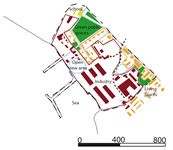
 As it can be seen in the map, many monuments are located in our project area of the Professors village. The area used to be a huge forest on the outskirts of the inner city, but at the beginning of the 20th century, the peninsula became more and more an industrial area. For military defense large shipyards were built, in which among other things submarines and military ships were manufactured.
 -
 Some of the industrial buildings are still preserved and recognized as heritage buildings. In total, there are around 27 heritage buildings and one historical monument in our working area. However, not only the yards (including e.g. the Bekker shipyard and the Russian-Baltic shipyard) were built, but entire settlements rised around them. They offered apartments and even schools, shopping and other facilities for the workers and their families.
 -
 In particular, the residential buildings of factory officials, managers and engineers are still in a good condition and attractive sights. The beautiful, mostly wooden houses are valued by the city as an important part of Tallinns cultural heritage. This is also were the name of Professors village comes from. Most of the monuments are empty today, but a few are still used: for example the main factory building of the Russian-Baltic shipyard is occupied by the Estonian Maritime Academy today.


Visual appearance and landscape narrative
- Which elements are essential for the landscape character?
- Has the landscape been painted or otherwise depicted, when and whom? Which elements are essential?
- Which narratives exist? Who has written about this landscape or depicted it in some way?
- You can add text and images
The landscape character of the area is predominantly defined by two elements, the physical factors defined by the coastal landscape and the industrial heritage in which the human shaped the landscape and adapted it in pursuit of economic growth. The oak forest of the peninsula dates back to 1365. But as is the case with many cities that suffered a rapid growth at the beginning of the 20th century, the peninsula became more of an industrial area, especially thanks to coastal setting and the building of the railway in 1870. When shipyards were built on Kopli peninsula in the early 1912s, most of the coast was rendered inaccessible to the general public in the area. Settlements that included residential quarters, schools, kindergartens, shops, and churches were raised around the industrial area to accommodate the huge number of workers. Parks were also planned as part of the green infrastructure. It was planned to build a representative park in the Kopli Peninsula, but this idea was not realized. Süsta Park is one of the green areas preserved to this day. Even though the settlements are no longer connected with the industrial area. Professor’s Village’ is an area of wooden houses that have survived the decline of Kopli as is seen on the area on the other side of the tram line, as Oliver Orro[1] depicted it.
“Many buildings that have been left vacant have burned down by now or stand in ruins. The original, integrally planned structure of the factory settlement is perishing to a great extent.”
Elements that shaped the landscape during industrialization are depicted in quite a few painting including in the works of Jaan Elken 1981 and 1983 paintings “Paljassaare“ ([2],[3]), and “Kaater” [4].
-
add a caption
-
add a caption
-
add a caption
A.2 Summary of you landscape system analysis and your development Targets
- You can summarize your findings with an DPSI(R) Model or a Spider Diagram
- Link back to the Sustainable Development Goals: Which goals are at risk?
- What is your hypothesis for this landscape?
- Visualise your hypothesis with one graphic/pict
- Are there any existing initiatives taking action in this landscape? Do you have a critical perspective on that?
- Add text and visuals
-
explain your analysis briefly in the caption
-
explain your hypthesis briefly in the caption
A.3 Theory reflection
- Reflect on at least three international policy documents in relation to their local landscape case
- choose one international, one European and one national document
- You can choose references from our reading list
- Scope: 250 words
A.4 References
- give a full list of the references you have used for this section
Phase B: Landscape Evaluation and Assessment
B.1 Assessment Strategy
- Based on the hypothesis derived from your previous landscape systems analysis you are now asked to define the goals for assessing the landscape. Your assessment is the basis for evaluating the landscape status.
- Which elements and phenomena need to be mapped, why and how?
- This a text contribution, max 250 words
B.2 Mapping
- As defined by your assessment strategy you conduct the mapping and present your findings here
- As a minimum, at least three different themes need to be mapped, you may choose more if needed
-
briefly explain the findings of your mapping
-
briefly explain the findings of your mapping
-
briefly explain the findings of your mapping
B.3 Problem definition and priority setting
- Give a summary of the major findings of your mapping process, what are the problems/potentials identified?
- Draw a problems/potentials map
- Set priorities for the most relevant issues
-
add caption here
B.4 Theory reflection
- Please reflect the assessment and evaluation methods used based on at least three readings
- Did you encounter limitations'
- 200 words test contribution
B.5 References
- give a full list of the references you have used for this section
Phase C – Strategy and Master Plan
C.1 Goal Setting
- Define strategic planning objectives based on the evaluation findings
- Link back to your original targets from section one and the Development Goals
- 150 words text contribution
C.2 Spatial Strategy and Transect
- translate your strategic goals into a vision
- develop a spatial translation of your vision
- exemplify your vision in the form of a transect with concrete interventions
- add map(s) and visualizations
-
add caption here
-
add caption here
-
add caption here
-
add caption here
C.3 From Theory of Change to Implementation
- For implementing your vision: Which partnerships are needed? Which governance model is required?
- Who needs to act and how? Draw and explain a change/process model/timeline
- Which resources are needed? On which assets can you build?
- add 150 words text and visuals
-
add caption here
-
add caption here
C.4 References
- give a full list of the references you have used for this section
D. Process Reflection
- Reflect in your intercultural and interdisciplinary team on the outcomes of your study
- Which limitations were you facing?
- What have you learnt from each other?
- What would you do differently next time?
- You can also use diagrams/visuals
- 250 words text