Case Study A: Merimetsa-Stroomi: Difference between revisions
| Line 108: | Line 108: | ||
<gallery caption=" " widths="500px" heights="200px" perrow="5"> | <gallery caption=" " widths="500px" heights="200px" perrow="5"> | ||
File:Merimetsa_image_case_study_hypotesis.jpg|'' | File:Merimetsa_image_case_study_hypotesis.jpg|''Both the absent interventions on the marshy area, and the increase of uncontrolled activities, such as those of the Ippodrom, sports and bathing, could damage the natural zone of Merimetsa. It could happen not only because of them but also because of the growth of the city around the forest, which is not all included in the protected area.'' | ||
</gallery> | </gallery> | ||
Revision as of 19:03, 4 April 2019
>>>back to working groups overview
| Area | Merimetsa/Stroomi | |
| Place | Tallinn | |
| Country | Estonia | |
| Topics | please enter the main coast-related topics here | |
| Author(s) | Please enter your name(s)- optional | |

| ||
Rationale
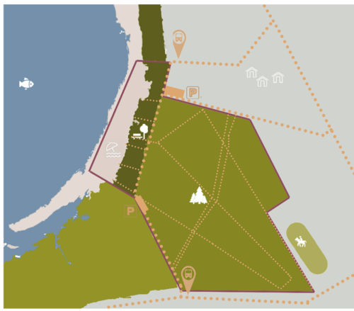
Merimetsa/Stroomi is an area of the north Tallinn district characterized by a biodiversity to preserve and different kinds of landscape. From the sea to the city, there are Stroomi sandy beach, a park with a marshy area and an urban forest where there is a protected area. Each of them is intended for different uses: there is a bathing beach, play areas for children, grilling areas in the park and path through the woods in the forest. However, many natural barriers make difficult to pass through the different areas. The main challenges are making new connections to integrate the different activities of this area and promoting tourism, but in the same time preserving rich ecosystem, biodiversity and making interventions on the marshy area, in order to avoid further damage in the zone.
Location and scope
A Landscape System Analysis
A.1 Landscape layers and their system context
Geomorphology, landscape units and coastal typology
- Description of evolution, status quo and driving forces, is the coastal typology changing? Why is that? (approx 200 signs)
- add 1-2 graphical representations to the image gallery, you can add more if you like
-
add a caption
-
add a caption
Land use
- settlements, infrastructure, agriculture, resource extraction, natural areas, energy production...
- description of evolution, status quo and driving forces, is the land use likely to change? Why is that? (approx 200 signs)
- add 1-2 graphical representations to the image gallery, you can add more if you like
-
add a caption
-
add a caption
-
add a caption
Green/blue infrastructure
- What are the major potential elements of a green/blue infrastructure network? Are these likely to change/disappear? Why is that?
- You find my background material on green infrastructure in our reading list
- add 1-2 graphical representations to the image gallery, you can add more if you like
-
 green & blue infrastructure & their accessability
 -
add a caption

Actors and stakeholders
- Merimetsa/Stroomi coastal area is part of Tallinn municipality, which is divided into 8 districts. Merimetsa/Stroomi belonging to Põhja-Tallinn district. Each district has its own government that fulfills the functions assigned to them by Tallinn legislation and statutes. The changes in the landscape are mostly driven by them. The 48 hectares big nature reserve on the project area is ruled by the Ministry of Environment and owned by the State Forest Management Centre (RMK). The surrounding area has a lot of apartments, so for a lot of people it’s the nearest green space available. There are a lot of local people whose life quality it improves a lot. Right now local people are probably the ones with the least power to make changes. In the future there is a possibility for local people to collaborate with a non-profit organisation called Linnalabor to have a more powerful voice and to improve urban space.
-
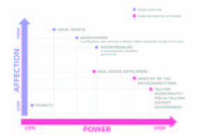 Power map of Merimetsa/Stroomi coastal area showing different actors/stakeholders and their power/affection.

Sacred spaces and heritage
- Which places/elements hold cultural value and to whom?
- You may add a map and some images, please also explain in your caption why these elements are valuable
-
add a caption
-
add a caption
-
add a caption
Visual appearance and landscape narrative
- Which elements are essential for the landscape character?
- Has the landscape been painted or otherwise depicted, when and whom? Which elements are essential?
- Which narratives exist? Who has written about this landscape or depicted it in some way?
- You can add text and images
-
add a caption
-
add a caption
-
add a caption
A.2 Summary of you landscape system analysis and your development Targets
- You can summarize your findings with an DPSI(R) Model or a Spider Diagram
- Link back to the Sustainable Development Goals: Which goals are at risk?
- What is your hypothesis for this landscape?
- Visualise your hypothesis with one graphic/pict
- Are there any existing initiatives taking action in this landscape? Do you have a critical perspective on that?
- Add text and visuals
-
explain your analysis briefly in the caption
-
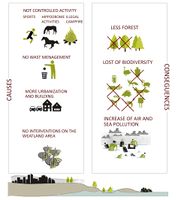 Both the absent interventions on the marshy area, and the increase of uncontrolled activities, such as those of the Ippodrom, sports and bathing, could damage the natural zone of Merimetsa. It could happen not only because of them but also because of the growth of the city around the forest, which is not all included in the protected area.

A.3 Theory reflection
- Reflect on at least three international policy documents in relation to their local landscape case
- choose one international, one European and one national document
- You can choose references from our reading list
- Scope: 250 words
A.4 References
- https://www.tallinn.ee/est/geoportaal/Rakendused-2
- https://register.metsad.ee/#/
- https://www.riigiteataja.ee/akt/413042017008
- http://register.keskkonnainfo.ee/envreg/main?reg_kood=KLO5000024&mount=view#HTTPG3uSnPzNZWYDzqgNL2BtuBNxZ6BbUX
- https://www.un.org/sustainabledevelopment/sustainable-development-goals/
- Merimetsa kaitseala kaitsekorralduskava 2018-2027
- http://kunilaart.ee/en/artist/paul-burman/
- https://commons.wikimedia.org/wiki/File:Paul_burman_Stroomi.jpg
- https://www.alamyimages.fr/photo-image-environs-de-tallinn-kaart-kava-lestonie-le-reval-ancienne-carte-antique-1912-baedeker-139060518.html
- "https://en.wikipedia.org/wiki/Tallinn"
Phase B: Landscape Evaluation and Assessment
B.1 Assessment Strategy
- Based on the hypothesis derived from your previous landscape systems analysis you are now asked to define the goals for assessing the landscape. Your assessment is the basis for evaluating the landscape status.
- Which elements and phenomena need to be mapped, why and how?
- This a text contribution, max 250 words
B.2 Mapping
- As defined by your assessment strategy you conduct the mapping and present your findings here
- As a minimum, at least three different themes need to be mapped, you may choose more if needed
-
briefly explain the findings of your mapping
-
briefly explain the findings of your mapping
-
briefly explain the findings of your mapping
B.3 Problem definition and priority setting
- Give a summary of the major findings of your mapping process, what are the problems/potentials identified?
- Draw a problems/potentials map
- Set priorities for the most relevant issues
-
add caption here
B.4 Theory reflection
- Please reflect the assessment and evaluation methods used based on at least three readings
- Did you encounter limitations'
- 200 words test contribution
B.5 References
- give a full list of the references you have used for this section
Phase C – Strategy and Master Plan
C.1 Goal Setting
- Define strategic planning objectives based on the evaluation findings
- Link back to your original targets from section one and the Development Goals
- 150 words text contribution
C.2 Spatial Strategy and Transect
- translate your strategic goals into a vision
- develop a spatial translation of your vision
- exemplify your vision in the form of a transect with concrete interventions
- add map(s) and visualizations
-
add caption here
-
add caption here
-
add caption here
-
add caption here
C.3 From Theory of Change to Implementation
- For implementing your vision: Which partnerships are needed? Which governance model is required?
- Who needs to act and how? Draw and explain a change/process model/timeline
- Which resources are needed? On which assets can you build?
- add 150 words text and visuals
-
add caption here
-
add caption here
C.4 References
- give a full list of the references you have used for this section
D. Process Reflection
- Reflect in your intercultural and interdisciplinary team on the outcomes of your study
- Which limitations were you facing?
- What have you learnt from each other?
- What would you do differently next time?
- You can also use diagrams/visuals
- 250 words text