Case Study G: Paljassaare-Pikakari: Difference between revisions
| Line 209: | Line 209: | ||
It is interesting to study the Natura 2000 Birds Directive (Directive 2009/147/EC) [[http://ec.europa.eu/environment/nature/legislation/birdsdirective/index_en.htm]] in our case study because the north of Paljassaare peninsula is a special protection zone of Natura 2000 Birds Directive. This directive, addressing to the states, aims at protecting the 500 species of wild birds living in Europe (194 are threatened) ; and also creating a link between the different countries as migrating birds in particular cross borders. In Paljassaare, 200 birds can be seen, including 50 protected ; some measures can be applied. The habitat should be protected, in order to preserve the birds. No activity with a high impact should be implemented. The establishment of a restricted area during bird nesting show the direct influence of the directive. | It is interesting to study the Natura 2000 Birds Directive (Directive 2009/147/EC) [[http://ec.europa.eu/environment/nature/legislation/birdsdirective/index_en.htm]] in our case study because the north of Paljassaare peninsula is a special protection zone of Natura 2000 Birds Directive. This directive, addressing to the states, aims at protecting the 500 species of wild birds living in Europe (194 are threatened) ; and also creating a link between the different countries as migrating birds in particular cross borders. In Paljassaare, 200 birds can be seen, including 50 protected ; some measures can be applied. The habitat should be protected, in order to preserve the birds. No activity with a high impact should be implemented. The establishment of a restricted area during bird nesting show the direct influence of the directive. | ||
'' | '' | ||
<gallery caption=" " widths=" | <gallery caption=" " widths="700px" heights="200px" perrow="5"> | ||
File: | File:Scheme_Natura_2000_V2.jpg|''Link between natura 2000 guidelines and their implementation in Paljassaare reserve'' | ||
</gallery> | </gallery> | ||
Revision as of 09:08, 12 April 2019
>>>back to working groups overview
| Area | Paljassaare / Pikakari | |
| Place | Tallinn | |
| Country | Estonia | |
| Topics | Recreation, nature area, industry | |
| Author(s) | Constance, Franciska, Hélène, Mohamed, Neda, Pedram | |

| ||
Rationale
Paljassaare/Pikakari is a strategic site in the thematic of coastal landscapes because it is at the interface of Nature and Human activities. Indeed, Pikakari is a place close from the city centre (15mn by car) where tourists (mostly Tallinners) go to enjoy the sea and the beach. But close to the beach, there is also a Natura 2000 area with more than 80 species of protected birds. Thus, the area is quite fragile and a part of it is forbidden during nesting periods. Finally, industry is also present with the waste water treatment plant of Tallinn and Paljassaare port. In conclusion it is a site that can be very conflictual between industry and leisure/nature. Also, because of the activities established, the territory is divided and a long portion of coast on the west side of the Peninsula is not accessible. The challenge we identified is to make transversal connections across the Peninsula and to develop recreational activities that respect the natural areas (habitats, fauna and flora).
Location and scope
You can edit this map with the map editor
A Landscape System Analysis
A.1 Landscape layers and their system context
Geomorphology, landscape units and coastal typology
Paljassaare peninsula is a part of the Tallinn bay and the Gulf of Finland. Most of Tallinn bay has an artificial coastline. However, the coast of this peninsula is mainly composed with beaches. These are made of sand, pebbles or rocks [10]. The island began to emerge 700 years BC [11]. This area is subjected to an isostatic uplift of the earth crust [12]. It means that this is an area that emerges of around 2 mm every year. Initially the peninsula was divided in two islands. Paljassaare is a peninsula since the 1950s, when garbage was stored in the mud of the bay, between the island and the mainland. The location of the site, close to the passage of the boats, makes it vulnerable to waves. The wind also has an impact on the area, as there is no high point to stop it. Humans also have an impact on the site. It is partly because of the beach. Being close to the city-center, it is well frequented in summer. This brings some pressure on the site, because of the cars. There is also a water treatment plant on the peninsula, which could lead to soil and water pollution.
-
![Map of the two Islands from L. A. Mellin's "Atlas von Lieffland" 1798 [[1]]](/images/thumb/b/bd/Mellin_atlas_von_lieffland_tallinn.png/103px-Mellin_atlas_von_lieffland_tallinn.png) Map of the two Islands from L. A. Mellin's "Atlas von Lieffland" 1798 [[1]]
Map of the two Islands from L. A. Mellin's "Atlas von Lieffland" 1798 [[1]] -
![Pikakari sand beach [[2]]](/images/thumb/c/c5/Pikakari_rand.JPG/200px-Pikakari_rand.JPG) Pikakari sand beach [[2]]
Pikakari sand beach [[2]] -
![Sand and pebbles beach [[3]]](/images/thumb/9/98/Paljassaare_hoiuala._01.jpg/200px-Paljassaare_hoiuala._01.jpg) Sand and pebbles beach [[3]]
Sand and pebbles beach [[3]] -
![Rocks [[4]]](/images/thumb/a/ac/Paljassaare_laht_2010-07-14.jpg/200px-Paljassaare_laht_2010-07-14.jpg) Rocks [[4]]
Rocks [[4]]
![Map of the two Islands from L. A. Mellin's "Atlas von Lieffland" 1798 [[1]]](/index.php?title=File:Mellin_atlas_von_lieffland_tallinn.png)
![Pikakari sand beach [[2]]](/index.php?title=File:Pikakari_rand.JPG)
![Sand and pebbles beach [[3]]](/index.php?title=File:Paljassaare_hoiuala._01.jpg)
![Rocks [[4]]](/index.php?title=File:Paljassaare_laht_2010-07-14.jpg)
Land use
The territory of Paljaassare is divided into five main land uses : transitional forest with mineral resources, open low and transfer bed, industrial and commercial territories, port and sparsely built up residential areas. Mainly the south part of area is an industrial and commercial unit whereas the north part has rather natural features.
Predominant land use in the area is industrial and commercial with some settlements, a main road is situated in the east with public transportation (bus connection to the center). According to the development of the area in the past decades, the map shows a visible change : going from shrinking ports bounds and enlarging the industrial area to reaching the coast in the east with settlements. We can say that it is likely that the port area will switch to a residential use in the future.
-
 Land use map,2000
 -
 land use map,2018
 -
 Legend
 -
 Paljassaare


Green/blue infrastructure
- Main green infrastructure:-
1- Paljassaare Special Conservation Area.
2- Green zone.
3- Swamp area.
- Main blue infrastructure:-
4- Pikakari beach.
5- Paljassaare Harbor.
6- kaelajarv.
According to the green/blue infrastructure areas mentioned it’s notable that the most of the study area is occupied by industrial use, and the main three green areas (1, 2, 3) is likely to develop in the future, first to maintain the ecological quality of Paljassaare district and eliminate any potential disturbance from the industrial zone, second to increase the connectivity between the green zones and Pikakari beach and the city center.
-
 GreenBlue Infrastructure

Actors and stakeholders
Paljassaare peninsula is situated in the North of the municipality of Tallinn, in Harju county. It is part of the Northern Tallinn district. It is quite an industrial area with Tallinn waste treatment plant (Tallinna Vesi - Water of Tallinn - 70 ha) [[13]] [[14]] and Paljassaare Port belonging to Port of Tallinn (Tallinna Sadam) [[15]] and several transportation companies as well as a railway. Around 50,000 inhabitants are living in the district [[16]]. In Estonia the planning process starts with the national government establishing the legal framework (laws and a national spatial plan). Then, counties do the county spatial plan and municipalities the comprehensive plan. Tallinn has a development plan for the period 2014-2020 [[17]]. According to several articles from 2018, Port of Tallinn would be looking to discard its last plots of Paljassaare harbor - most of it already sold over the past 10 years [[18]].
Who is affected highly but with low power? Who has high power but is not affected?
-
 Powermap of Paljassaare peninsula

Sacred spaces and heritage
The cultural heritage of Paljassaare is manly characterized by its military use. In the past Paljassaare was divided into two small islands called Karli Islands. With the end of the Great Northern War on Estonian territory, Estonia was incorporated into Russia. In 1727 the Russian leadership decided to strengthen the defences of the port of Tallinn.[[19]] At this time the first military fortifications were built on Karli island (later Paljas-saare). In 1824 an artillery Tower was built on the smaller Karli island.[[20]] The unofficial name of the tower became "White Tower" (Valge torn). Nowadays only ruins of the tower exist since the Russian troops destroyed the Tower during the Crimean War because of the fear that it will fall in the hands of the enemy. Before and during World War I a complex protecting system was built. The large complex of fortifications should protect St. Petersburg form attacks by the sea. The system was called Peter the Great´s naval fortress.[[21]] The construction started on Paljassaare in 1912. The area between the mainland and the islands was filled and the result is the peninsula Paljassaare. The material to fill the area was collected during construction of the Mine Harbour.[[22]] The construction of the complex protection system was never finished. Today only the ruins of the White Tower, the battery, the embankment of the railway and the Katariina Quay is left from the naval fortress.
![Timeline of the military history of Paljassaare[[5]] [[6]]](/index.php?title=File:Zeitstreifen_Gesamt.png)
-
Pictures will be added after the fieldtrip on Saturday
-
Pictures will be added after the fieldtrip on Saturday
-
Pictures will be added after the fieldtrip on Saturday
Visual appearance and landscape narrative
Local visual arts can be considered into three different time periods. The 19th century, Soviet time and Post Soviet time. In the 19th century many landscape painters such as Carl Ferdinand von Kügelgen, Edouard Hostein and Victor-Vincent Adam visited this area and produced many art pieces depicting local nature. In Soviet times many Estonian painters started to show effects of Soviet ideas about human society and lifestyle of young people and next generations. Ilmar Ojalo and especially Jaan Elken are the most important painters from that period, Jaan Elken published more than 200 writings on art and arts policy. Elken has been the head of Estonian Painters’ Union (1995-1999) and the president of Estonian Artists’ Association (1999-2013). Since 1997 he is a professor of the Chair of painting at The Institute of Cultural Research and Fine arts at the University of Tartu. In current time Paljassaare-Pikakari has a new generation of artists who are inspired by new face of this area. They are trying to tell stories from one of the most poorest parts of Tallinn in different ways. Most common medium among them is photography and graffiti, Mattias Malk and Tõnis Saadoja are the most famous young local artists nowadays. [[23]]
-
 Carl Friedrich Christian Buddeus-Kopli Beach(1836)
 -
 Jaan Elken-Paljassaare(1983)
 -
 Street Art in Paljassaare peninsula
 -
 Mattias Malk-Secret Slum Book(2017)


.jpg)

A.2 Summary of you landscape system analysis and your development Targets
Summary of the DPSI framework
DRIVING FORCES
Human activity:
- Industrial areas
- Tourism >> bird watching area
- Recreational activities at the beach
- Urbanization
Natural processes:
- Waves
- Floods
- Strong Wind
PRESSURES
- Air pollution
- Heavy Traffic
- Water pollution
- Soil pollution
STATE
Almost a century ago Paljassaare was divided into two small islands. The area includes abandoned military structures, diverse nature, industry, Paljassaare Harbour and a small area of settlements. In 2005 the Paljassaare Special Conservation Area was established following the guidelines of NATURA 2000. This area has a valuable nature and a unique bird zone. Because of these two facts there is an increasing touristic activity. The Pikakari beach is also a strong magnet for the people of the surroundings, this also implies a lot of individual traffic in this area. The accessibility with public transport system is not well developed. Paljassaare Harbour will be closed in the future and there are already plans to urbanize the area.[[24]] A big part of Paljassaare is the wastewater treatment plant, almost all the waste water of Tallinn is purified on this place. This industry is likely to stay in place in the long term. Several business and private areas prevent the free access to the coastline and connections from the East to the West.
IMPACTS
- Air pollution >> bad air quality, which also influence the recreational and protected nature areas
- Popular area >> more disturbances on the protected bird area
- Perturbation of flora and fauna and their life cycles
-
![Graphical overview of the DPSI model [[7]]](/images/thumb/5/5c/DPSI_Paljassaare.jpg/400px-DPSI_Paljassaare.jpg) Graphical overview of the DPSI model [[7]]
Graphical overview of the DPSI model [[7]]
![Graphical overview of the DPSI model [[7]]](/index.php?title=File:DPSI_Paljassaare.jpg)
Hypothesis
If all the driving forces just continue as they do, we can image various conflicts. In the next few years the infrastructure to Paljassaare should be developed, so more people could visit the reserve nature area. In this case we need a balanced development strategy between the improvement of the accessibility and the protection of the nature area in the northern part. The bird watching area includes high valuable ecological elements, which must be protected. In the future the industrial area, especially Paljassaare Harbour should be rebuilt and the emergent area should be urbanized. The existing detail plans will overlap with the nature reserve.[[25]][[26]] Also the constructions near to the reserve can have negative effect. The number of nesting birds and species under protection can be unstable.[[27]] Another risk of high urbanisation on the costal area is that the coastline can lose its function as a public city space. The rising sea level is a long-term risk. However, possible safety precautions must be considered for future planning as the area has a floodable feature.
![Graphical overview of the hypothesis [[8]][[9]]](/index.php?title=File:Hypothesis_paljassaare.jpg)
Sustainable Development Goals
Life below Water
The industry, the increasing urbanisation and the number of visitors at the beach are risks for the goal Life Below Water. The area must struggle with more waste on the beach, water pollution, more traffic and increasing percentage of impervious surface. Those effects are linked with the protection of biodiversity in the coastal areas and in the ocean.[[28]]
Life on Land
The high pressure of urbanisation also endangers the objective Life on Land. The existing development plan shows an overlap with the new housing area and the nature reserve. The development of the urban area must be in balance with nature areas. [[29]]
A.3 Theory reflection
Natura 2000 Birds Directive
It is interesting to study the Natura 2000 Birds Directive (Directive 2009/147/EC) [[30]] in our case study because the north of Paljassaare peninsula is a special protection zone of Natura 2000 Birds Directive. This directive, addressing to the states, aims at protecting the 500 species of wild birds living in Europe (194 are threatened) ; and also creating a link between the different countries as migrating birds in particular cross borders. In Paljassaare, 200 birds can be seen, including 50 protected ; some measures can be applied. The habitat should be protected, in order to preserve the birds. No activity with a high impact should be implemented. The establishment of a restricted area during bird nesting show the direct influence of the directive.
-
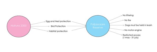 Link between natura 2000 guidelines and their implementation in Paljassaare reserve

Tallinn Development Plan 2014 -2020
The development Plan is based on the development strategy “Tallinn 2030”. The development plan describes six main objectives.[[31]]
- Tallinn with a highly productive economy
- An educated, capable and open Tallinn
- Tallinn with diverse activities and full experiences
- A (socially) safe Tallinn, with managed risks
- Tallinn with comfortable, inspiring and environmentally sound urban space
- Tallinn with effective city agencies that have knowledge-based management and a good service culture
-
 Impacts on Paljassaare

![[1]](https://commons.wikimedia.org/wiki/File:Mellin_Atlas_von_Lieffland_Tallinn.png)
![[3]](https://commons.wikimedia.org/wiki/File:Paljassaare_hoiuala._01.jpg)
![[4]](https://commons.wikimedia.org/wiki/File:Paljassaare_laht_2010-07-14.jpg)
A.4 References
Geomorphology, landscape units and coastal typology
[2] Great Paljassaare https://et.wikipedia.org/wiki/Suur_Paljassaar
[3] Eurosion case study http://discomap.eea.europa.eu/map/Data/Milieu/OURCOAST_323_EE/OURCOAST_323_EE_Doc_TallinnEurosionCS.pdf
[4] Map of the to Islands from L. A. Mellin's "Atlas von Lieffland" 1798: https://commons.wikimedia.org/wiki/File:Mellin_Atlas_von_Lieffland_Tallinn.png
[5] Picture Pikakari sand beach: https://vimeo.com/70435719
[6] Picture Sand and pebbles beach: https://commons.wikimedia.org/wiki/File:Paljassaare_hoiuala._01.jpg
[7]Picture Rocks: https://commons.wikimedia.org/wiki/File:Paljassaare_laht_2010-07-14.jpg
Land use
[8]1990,2018 https://corine.keskkonnaagentuur.ee/
Green/blue infrastructure
Actors and stakeholders
[11] Tallinna Vesi website https://tallinnavesi.ee/en/corporate-social-responsibility/ekskursioonid/paljassaare-reoveepuhastusjaam/
[12] Maaamet http://xgis.maaamet.ee/maps/XGis
[13] Paljassaare Port website http://www.portoftallinn.com/paljassaare-harbour
[14] Northern Tallinn District https://www.tallinn.ee/northern-tallinn
[15] Tallinn City website https://www.tallinn.ee/eng/
[16] Article by Merilin Pärli on err.ee https://www.err.ee/842057/tallinna-sadam-paneb-paljassaare-sadama-varad-ilmselt-enampakkumisele
Sacred spaces and heritage
[17] Website Tallinn port: http://www.portoftallinn.com/18th-century
[18] Webportal about urban nature: https://citynature.eu/en/location/paljassaare/?section=history
[19] Wikipedia articl about Paljassaare: https://et.wikipedia.org/wiki/Paljassaare
[20] Website about Estonian history: http://www.estonica.org/en/Peter_the_Great%E2%80%99s_naval_fortress/
[21] Website about Estonian history: http://www.estonica.org/en/History/1914-1920_The_First_World_War_and_Estonian_independence/World_War_I/
[22] Website about Estonian history: http://www.estonica.org/en/History/1558-1710_Estonia_under_Swedish_rule/The_Great_Northern_War_End_of_Swedish_rule_in_Estonia/
Visual appearance and landscape narrative
[23] www.mattiasmalk.com http://www.mattiasmalk.com/?section=secret-slum-the-most-safe-place-in-kopli
[24]secret-slum https://soundcloud.com/user-525571669/secret-slum-the-most-safe-place-in-kopli
[25] www.jaanelken.com http://www.jaanelken.com/
[26] digikogu.ekm.ee https://digikogu.ekm.ee/eng
A.2 Summary of your landscape system analysis and your development targets
[27] Website Paljassaare Artificial Island: http://sults.ee/sa-paljassaare-kultuurilaiud-kultuurisaarestiku-tutvustus/
[28] Icons from Noun Project: https://thenounproject.com
[29] Tallinn plan register: https://tpr.tallinn.ee/MapOfPlannings/Linnaosa/100276
[30] Settelment plan Paljassaare: http://adepte.ee/wp-content/uploads/2013/06/24691_phijoonis.pdf
[31] Master Thesis PDF: https://dspace.emu.ee/xmlui/bitstream/handle/10492/4210/Kruus_Kertu_AR_mag_2018.pdf?sequence=1&isAllowed=y
[32] Climate Change Adaptation Development Plan until 2030 PDF: https://www.envir.ee/sites/default/files/national_adaptation_strategy.pdf
[33] Website The EU Strategy on Green Infrastructure: http://ec.europa.eu/environment/nature/ecosystems/strategy/index_en.htm
[34] Website about the Sustainable Development Goals: https://www.un.org/sustainabledevelopment/oceans/
[35] Website about the Sustainable Development Goals: https://www.un.org/sustainabledevelopment/biodiversity/
Theory reflection
[36] Natura 2000 Birds Directive http://ec.europa.eu/environment/nature/legislation/birdsdirective/index_en.htm, PDF document available at : https://eur-lex.europa.eu/legal-content/EN/TXT/?uri=CELEX:32009L0147
[37] Tallinn Development Plan 2014 -2020 PDF avaiable here: https://www.tallinn.ee/eng/
Phase B: Landscape Evaluation and Assessment
B.1 Assessment Strategy
- Based on the hypothesis derived from your previous landscape systems analysis you are now asked to define the goals for assessing the landscape. Your assessment is the basis for evaluating the landscape status.
- Which elements and phenomena need to be mapped, why and how?
- This a text contribution, max 250 words
B.2 Mapping
- As defined by your assessment strategy you conduct the mapping and present your findings here
- As a minimum, at least three different themes need to be mapped, you may choose more if needed
-
briefly explain the findings of your mapping
-
briefly explain the findings of your mapping
-
briefly explain the findings of your mapping
B.3 Problem definition and priority setting
- Give a summary of the major findings of your mapping process, what are the problems/potentials identified?
- Draw a problems/potentials map
- Set priorities for the most relevant issues
-
add caption here
B.4 Theory reflection
- Please reflect the assessment and evaluation methods used based on at least three readings
- Did you encounter limitations'
- 200 words test contribution
B.5 References
- give a full list of the references you have used for this section
Phase C – Strategy and Master Plan
C.1 Goal Setting
- Define strategic planning objectives based on the evaluation findings
- Link back to your original targets from section one and the Development Goals
- 150 words text contribution
C.2 Spatial Strategy and Transect
- translate your strategic goals into a vision
- develop a spatial translation of your vision
- exemplify your vision in the form of a transect with concrete interventions
- add map(s) and visualizations
-
add caption here
-
add caption here
-
add caption here
-
add caption here
C.3 From Theory of Change to Implementation
- For implementing your vision: Which partnerships are needed? Which governance model is required?
- Who needs to act and how? Draw and explain a change/process model/timeline
- Which resources are needed? On which assets can you build?
- add 150 words text and visuals
-
add caption here
-
add caption here
C.4 References
- give a full list of the references you have used for this section
D. Process Reflection
- Reflect in your intercultural and interdisciplinary team on the outcomes of your study
- Which limitations were you facing?
- What have you learnt from each other?
- What would you do differently next time?
- You can also use diagrams/visuals
- 250 words text