Case Study C: Cemetery Park: Difference between revisions
Marta.porcu (talk | contribs) |
Marta.porcu (talk | contribs) |
||
| Line 141: | Line 141: | ||
<gallery caption=" " widths="200px" heights="150px" perrow="5"> | <gallery caption=" " widths="200px" heights="150px" perrow="5"> | ||
Coland_tallinn_3_Page_09.jpg|''Visual appearance and landscape narrative '' | Coland_tallinn_3_Page_09.jpg|''Visual appearance and landscape narrative '' | ||
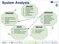
== A.2 Summary of you landscape system analysis and your development Targets == | == A.2 Summary of you landscape system analysis and your development Targets == | ||
Revision as of 10:11, 12 April 2019
>>>back to working groups overview
| Area | Kopli Cemetery Park | |
| Place | Tallinn / Kopli | |
| Country | Estonia | |
| Topics | Land use & Heritage | |
| Author(s) | Carmine Montuoro, Marta Porcu, Sabina Dragomirescu, Melina Haures, Magdalena Giefert, Ahmed Abdelhafaz, Hoang LeMinh, Andi Järvsoo | |

| ||
Rationale
- Why do you think this case is relevant? What is your hypothesis considering the landscape challenges?
- Format: 3-4 sentences
MAGNET - RESILIENCE - RECREATION
As Tallinn is a city by the sea it is important to keep the coastline natural as possible but still accessible to use for the citizens. Open spaces near coast gives opportunities to develop new recreational areas. Coastline will be moved towards the land (consequence of the climate change) > it requires a proper planning strategy resulting in a resilient coastal landscape.
Location and scope
You can edit this map with the map editor
A Landscape System Analysis
A.1 Landscape layers and their system context
Geomorphology, landscape units and coastal typology
- The coast of Talinn is 46 kilometers long, Kopli peninsula being part of it. Its borders are comprised of three bays: Talinn, Kopli and Paljassaare. Located in the suburb of Kopli, Kopli cemetery opens to the beach. Regarding the coastal typology, till coasts make 8% of the shoreline length, sandy coasts – 33%, silty coasts – 8% and cliffed coasts – 51%.
- The geological history is related to the isostatic uplift of the Earth’s crust in the northern part of the Baltic Sea region, which still continues (ca. 2 mm annually). The coastline is made up of rocks and sediments of till, varved clay, sand, gravel and pebbles. Their origin is glacial, marine and lacustrine and dates from various periods of time. The soft rock bluffs of Quarternary glacial drift deposits is the most specific for the Kopli peninsula. Due to the uplift of the Earth’s crust, the character of the Estonian coast and beaches is emergent.
- The main driving forces for the coastal typology changes are naturally and human based. On one hand, we can talk about the wave activity and the wind-induced surge during storms that along with the global warming may be the cause of future changes. On the other hand, human exploits are equally important in causing typological damages, this being the first factor that we are able to control.
-
 focus area
 -
 coastal typologies
 -
 focus area typology


Land use
Kopli Cemetery park case study area is a combination of:
1. Discontinuous urban fabric
2. Green urban areas
3. Agricultural, semi-natural areas
4. Industrial or commercial units
5. Port areas
6. Dump sites
7. Railways and associated land
8. Land without current use
Most predominant land uses in the case study area are industrial/commercial units with dense resident areas. Through time there has not been many significant changes much bring out. In the connection areas however land cover maps from decades ago is showing how port areas is converted into the Industrial commercial units. Analysis of the area and City planning documents shows how the surrounding area has different architectural buildings from different time periods. Most closest and important to bring out is single family house area that is located west from the Cemetery park in Sirbi street. It is also documented as a mileu valued space in Tallinn.
In the future Kopli cemetery park and its connecting areas could be in even more ugly state than its today. Old buildings are abandoned or not in good shape. A lot of old Industrial building ruins has no meaning right now with also bigger grass areas around them that are not maintained.
-
 Land use map
 -
![Land use changes from 1990 to 2018 (CORINE Land Cover map) [[1]]](/images/thumb/4/45/Group_3_Land_use_changes.png/200px-Group_3_Land_use_changes.png) Land use changes from 1990 to 2018 (CORINE Land Cover map) [[1]]
Land use changes from 1990 to 2018 (CORINE Land Cover map) [[1]] -
 Predominant land uses - Industrial & Dense urban area vs Green urban areas

![Land use changes from 1990 to 2018 (CORINE Land Cover map) [[1]]](/index.php?title=File:Group_3_Land_use_changes.png)

Green/blue infrastructure
- What are the major potential elements of a green/blue infrastructure network? Are these likely to change/disappear? Why is that?
- You find my background material on green infrastructure in our reading list
-
 Green infrastructure In this study area, there are parks, coastline park, and private gardens. The largest park is Kopli Cemetery Park is the main element of green infrastructure and magnet as well. Nearly 85% of this area is covered by green spaces and green areas, coastline and natural areas as well will be connected to a uniform citywide network. The coastline park with a lot of empty spaces so there are several potentials for recreation connected to the coastline area.
 -
 Blue infrastructure In this area, there is only the Coastline of Baltic sea which is the main blue infrastructure. This area is affected by flooding, some places with a high 0.5m and others up to 3 meters.


Actors and stakeholders
- Who is driving changes in this landscape? Who is affected by those changes?
- Draw a stakeholder and/or power map: Who is affected highly but with low power? Who has high power but is not affected?
-
 Stakeholders Power Map

Sacred spaces and heritage
- Which places/elements hold cultural value and to whom?
- You may add a map and some images, please also explain in your caption why these elements are valuable
Seeside:
Lighthouses Meeruse sadama sihi ülemine tulepaak ("upper lightbulb") and Meeruse sadama sihi alumine tulepaak ("bottom lightbulb") - existing light houses operate as a typical coastal landmarks which characterise the landscape.
Urban forest:
Kopli Park is a former Cemetery called “Friedhof von Ziegelskoppel“- the biggest necropolis (Lutheran Baltic German cemetery) in Estonia, established in 1774 and destructed in 1951 by Soviet authorities. Also many prominent Estonian citizens were buried here. No trace of the cemetery was left standing. The gravestones were used to build walls and sidewalks in other parts of the city. Kopli Park has for sure strong and clear cultural value for the Tallinn citizens. Former cemetery has a great value for the older/passing generations of Estonians. Young generations possibly do not inherit the attitude to the past form of the Kopli Park.
-
 Sacred places
 -
 Lighthouse
 -
 Lighthouse in Winter
 -
 Kopli Park today
 -
 Historical traces of the cemetary
 -
 Kopli Park today


Visual appearance and landscape narrative
- The representation of the area start from the postcards: through this type of representation we can studied the evolution of the landscape and we understand how the coast is the principal element, not only of this project area, but of the entire city.
- The paintings, mostly realized during the romantic movement, shows not only the atmosphere that served to describe the coast, but also the importance of the subjects: the boats, considered element of connection with other countries and element of maritime trade. In particular the painting by Evald Okas, "Kopli rand" from the 1930s, is characterized by a different atmosphere from the others, represents part of the project area, and we could assume that the boat represented could belong to one of the fishermen who live nearby.
- The b&w photos represent the Kopli cemetery in the past, razed to the ground later by the Soviet power present in Estonia. This is an important element for the area of study because the remains of the tombstones, have been used for the construction of sidewalks and walls of other parts of the city. This 'narration' connects the project area, and more the rest of the city.
-
 Visual appearance and landscape narrative
 -
 explain your analysis briefly in the caption


-
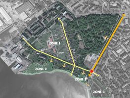 Zone 1: Houses fo residence will be filled up in the future. Zone 2: The coastline is new destination of outdoor recreation for locals that is connected to Zone 3 to make a green coastline system for Tallinn.

-
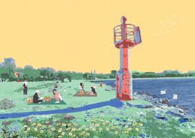 Open spaces near coast gives opportunities to develop new recreational areas. This place people can garther together, have several outdoor activities and take a look The Light as an opportunity.

A.3 Theory reflection
- Reflect on at least three international policy documents in relation to their local landscape case
- choose one international, one European and one national document
- You can choose references from our reading list
- Scope: 250 words
A.4 References
- Google maps - photos https://tiny.pl/t7981
- Blog - Tania Lestal https://tiny.pl/t798p
- Kultuurimälestiste riiklik register https://register.muinas.ee/ and http://xgis.maaamet.ee/xGIS/XGis
- CORINE Land cover map https://land.copernicus.eu/pan-european/corine-land-cover
- Green urban areas incorporating Sustainable Land Use https://webcache.googleusercontent.com/search?q=cache:rWr0fJXPqtsJ:https://www.tallinn.ee/Indicator-3_Green-areas_Land-use_Tallinn+&cd=2&hl=en&ct=clnk&gl=ee
- Tallinn environmental strategy to 2030 http://webcache.googleusercontent.com/search?q=cache:trNlgjPwja0J:www.tallinn.ee/strateegia_ingl+&cd=3&hl=en&ct=clnk&gl=ee
- Tallinn development plan 2014–2020 https://webcache.googleusercontent.com/search?q=cache:KMVpj3AyMU8J:https://www.tallinn.ee/Tallinna_Arengukava_ENG_preview_veebi+&cd=4&hl=en&ct=clnk&gl=ee
Phase B: Landscape Evaluation and Assessment
B.1 Assessment Strategy
- Based on the hypothesis derived from your previous landscape systems analysis you are now asked to define the goals for assessing the landscape. Your assessment is the basis for evaluating the landscape status.
- Which elements and phenomena need to be mapped, why and how?
- This a text contribution, max 250 words
B.2 Mapping
- As defined by your assessment strategy you conduct the mapping and present your findings here
- As a minimum, at least three different themes need to be mapped, you may choose more if needed
-
briefly explain the findings of your mapping
-
briefly explain the findings of your mapping
-
briefly explain the findings of your mapping
B.3 Problem definition and priority setting
- Give a summary of the major findings of your mapping process, what are the problems/potentials identified?
- Draw a problems/potentials map
- Set priorities for the most relevant issues
-
add caption here
B.4 Theory reflection
- Please reflect the assessment and evaluation methods used based on at least three readings
- Did you encounter limitations'
- 200 words test contribution
B.5 References
- give a full list of the references you have used for this section
Phase C – Strategy and Master Plan
C.1 Goal Setting
- Define strategic planning objectives based on the evaluation findings
- Link back to your original targets from section one and the Development Goals
- 150 words text contribution
C.2 Spatial Strategy and Transect
- translate your strategic goals into a vision
- develop a spatial translation of your vision
- exemplify your vision in the form of a transect with concrete interventions
- add map(s) and visualizations
-
add caption here
-
add caption here
-
add caption here
-
add caption here
C.3 From Theory of Change to Implementation
- For implementing your vision: Which partnerships are needed? Which governance model is required?
- Who needs to act and how? Draw and explain a change/process model/timeline
- Which resources are needed? On which assets can you build?
- add 150 words text and visuals
-
add caption here
-
add caption here
C.4 References
- give a full list of the references you have used for this section
D. Process Reflection
- Reflect in your intercultural and interdisciplinary team on the outcomes of your study
- Which limitations were you facing?
- What have you learnt from each other?
- What would you do differently next time?
- You can also use diagrams/visuals
- 250 words text