Case Study F: East-Kopli: Difference between revisions
Marie.huron (talk | contribs) |
|||
| Line 203: | Line 203: | ||
<gallery caption=" " widths="500px" heights="200px" perrow="5"> | <gallery caption=" " widths="500px" heights="200px" perrow="5"> | ||
File: | File: PotEastKopli.jpg ''East Kopli Potentials'' | ||
</gallery> | |||
<gallery caption=" " widths="500px" heights="200px" perrow="5"> | |||
File: ProbEastKopli.jpg ''East Kopli Problems'' | |||
</gallery> | </gallery> | ||
Revision as of 07:22, 10 May 2019
>>>back to working groups overview
| Area | East Kopli | |
| Place | Tallinn, Kopli | |
| Country | Estonia | |
| Topics | Wild Coastline | |
| Author(s) | Soumaya Benaddia, Inès Masson, Hicham Karkouch, Elisa Ruocco, Mariangela Perillo, Rashad Gasimov, Tereza Slaba, Marie Huron, Liisa-Maria Tiidu
| |

| ||
Rationale
The area of East Kopli is a part of Tallin, which presents a suggestive landscape but also some difficulties. It is characterized by a former railway line along the edge of the area and there are private houses defined by high fences. There are also brownfields made up of wild vegetation, iron and concrete. There is also a large garage which contains aligned sheet metal with an entrance in the southern part. The coastline has not a beach, but ground mixed with algae and stones. It would be very interesting to create new connection points in order to improve environmental quality.
However, this place has many potentials and it could reborn through the project of sustainable infrastructures. The project could be the solution to preserve this precious area which is featured by an admirable landscape, starting from the development of the coastline that has an informal access to the sea. Moreover, the brownfields, as "waste" lands, could become places of aggregations based on an environmental improvement.
Location and scope
You can edit this map with the map editor
A Landscape System Analysis
A.1 Landscape layers and their system context
Geomorphology, landscape units and coastal typology
Landscape units
East Kopli is divided in 2 different space : • Natural area (or related to nature) : this area is divided by the shoreline, the pastures, arable land and a 29.5m hill. • Built up area : this area consists of different types of houses (a slum, small houses with garden (and a group of villa in the western edge) or industrial buildings.
Coastal typology
The site is located in Kopli, Tallin, in the Paljassaare Bay, in between Kopli peninsula and Väike Paljassaare peninsula. Kopli is located in a coastal zone, the region is directly influenced by marine processes. The site is characterized by a 25m on average wide shoreline and a pebble beach. There's a lake (salty lake?) located behind the shoreline.
Beach morphology
In the kopli’s coastal area, we have a strip of white beach, formed by sand and pebbles of sedimentary origin’s. These pebbles are carried by the currents or streams that flow down towards the coast.
-
 View from the hill
 -
 Plebbe Beach


Land use
Being on the outskirts of the city, with 6km distance to Tallinn Old City, East Kopli is developed as an Industrial Part. This development shaped the Peninsula. Worker Quarters also developed in that area. However, with the collapse of Soviets Industry abandoned, and the area used for construction waste. Maps produced in different times shows the development of the area. Also satellite images showing that some demolitions have been conducted in the area.
-
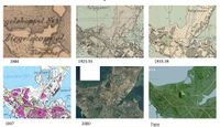 Area Development
 -
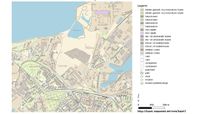 Land Use


Green/blue infrastructure
-
 For the blue mesh, three elements are notable. First of all, the site is located along the Baltic Sea. Nevertheless his beach is not used as such, it is covered with concrete blocks, algae and stones. The second point is the presence of three water zones, whose information about them is not easy to find. Thus, we can think that they are connected to the industrial zone to the north, bordering the site, serving as water reserves. The largest area seems to have good water quality thank's to the presence of aquatic vegetation as well as animals, such as swans. The second, located in the northern part, has two narrow watercourses whose drawing stops at the road level, in front of the industry. The last water zone seems disconnected from the other two. Finally, the last point is a limit cutting the studied area in two, which delimits a restriction to the water.
 -
 The green mesh is drawn according to three categories. First to the south a green corridor, planted with tall trees and a lawn, located on the old train tracks marks the beginning of the study area. It starts the second green zone marked by gardens located at the front and back of the houses, crossed by a long road leading to the sea. The vegetation is dense, there are trees, hedges , shrubs, low planted and wild vegetation, creating a visual barrier along the road. Finally, the rest of the area are brownfields with low type vegetation and wild suitable for some animals such as hares and rabbits that have been sighted there.


Actors and stakeholders
East-Kopli is a part of Tallinn, it is dominated by the North Tallinn government. In order to manage the activities of the district, the North Tallinn Government, which is led by the district governor, is established as the city authority. The Tallinn City Council, which is formed in accordance with the procedure provided for in the Statutes of Tallinn, acts as the working body of the City Council. In order to ensure the development of the city district and to ensure the normal functioning of the infrastructure in accordance with the unified interests and tasks of the city as a whole, and taking into account the specificity of the district, the city district solves the tasks assigned to it by the state and Tallinn legislation in the following areas like: social welfare, housing and communal services, waste management, spatial planning, sports and culture education etc. City governor, who leads the government, manages and organizes government work, signs other government documents or authorize other government officials to do so, ensure the preparation of the draft budget of the district government and the implementation of the budget of the district government and the keeping of records pursuant to the procedure provided for in the legislation of the state and the city.
Kopli Society and Charity The non-profit association Kopli Society has been engaged in charity for years, because the members of the Society are convinced that if possible, the fertilized people should be helped. But after the twenty-three children were given sports shoes and school bags and the state demanded a special discount on this activity, members of the Society are convinced that every good deed can be punished once.
-
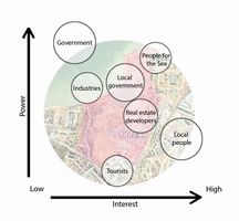 Power Map of East Kopli

Sacred spaces and heritage
Important part of cultural heritage in East-Kopli is natural heritage. Part of the area called Paljassaare is under European natural protection Natura 2000. It belongs under the Bird directive. In the area live around 227 bird species and 82 of them are protected by the directive.
Another significant part of cultural heritage in this area is a fishing tradition .
-
 Paljassare, Natura 2000

Visual appearance and landscape narrative
East Kopli district is characterized by a rather wild coastline. It is somehow accessible for people who wants to benefit from the proximity between Kopli district and the Baltic sea. Wide brownfields extend along the coast and offer residents the possibility to run or to bicycle in a peaceful and natural environment. However, despite these natural and recreational potentials, the area is not very welcoming. The accesses are not clear and an unsafe feeling is present throughout the site. An uncertain soviet past is floating in the atmosphere and remains unreadable.
A surprising 29,5 meters high hill is also characterizing this coastal landscape. It stands as the former Kopli landfill, which have been used until 2016. Hundred kilograms of waste are today covered by clay and grass. This “trash mountain” could offer unusual possibilities to overview the coast or hike on it.
The residential Neeme Street is also an important landscape character as it is composed of a series of individual houses. Their architecture are remarkable as they were built in the 1920s and refers to traditional Estonian houses. The Estonian architect Edgar Johan Kuusik (1888-1974) has designed a couple of wooden houses in this street. They reveal the quietness and the attractiveness of this coastline during the first part of the XXs century.
Finally, the East Kopli district stands as a place dominated by an abandoned post soviet landscape. The wild brownfields and the former landfill are key landmarks with huge potentials for biodiversity and maybe human recreation. The residential street shows that people are still living in this place on the hedge between the city and nature.
-
 Wild Eastern Kopli Coast through the perception of residents, 2017
 -
 Kopli Landfill, used until 2016
 -
 Private House in Neeme Street, Architect Edgar Kuusik, 1924


A.2 Summary of you landscape system analysis and your development Targets
The DPSR(I) model describes the interaction between the society and the environment. In this case it start from the analysis of five main words-drive, pressure, state, impact, resolve- in connection with the area of study.
-
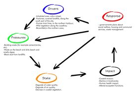 The DPSR(I) MODEL

The studied zone presents numerous elements and particular landscape features that hold a great deal of potential, but if all driving forces and current pressures are maintained, it could potentially lead to the take over of private stakeholders that would seize the opportunity and develop lucrative structures which is aimed at developing touristic attractions rather than promoting structures that would benefit local inhabitants and environmental wellbeing, such as hotels, resorts, and high-end housing. This would in turn lead to the rise of land value, and therefor lead to the impoverishment and gentrification of the area. On the other hand, this "attraction oriented development" could also cause environmental decline by putting pressure on the natural ressources, especially on the water front, and generating big amounts of waste that need to be managed.
-
 Possible "attraction driven" development (hotels, resorts, housing and so on). Which might lead to gentrification and cause social and environmental decline

A.3 Theory reflection
The European Landscape Convention
The European Landscape Convention of the Council of Europe promotes the protection, management and planning of the landscapes and organises international co-operation on landscape issues. Estonia signed the Convention on 20 December 2017 and the Convention entered into force for Estonia on 1 June 2018. [1] Landscape is an essential part of the living environment of both the individual and society as a whole and is therefore one of the values that the Council of Europe values. Landscape has a significant impact on people's quality of life and identity. It is also of great importance for the culture, social welfare, ecology and economy of society.
General plan of North-Tallinn
The development vision for North Tallinn envisages focusing on balanced and sustainable development of the city district. By 2030, the district of North Tallinn is citizen-centered and capable of administration; providing an attractive, healthy and safe living environment; valuing the historic ‐ cultural identity of settlements; open and balanced for the sea.
Natura 2000

Natura 2000 is a network of ptoected areas connecting countries of the European Union. It is a directive ( Directive 92/43/EEC ) valid for all countries of EU and a superiror law in natural protection for all members of the EU. The aim of protection is to ensure diversity and conservation of wild species (flora and fauna) among their natural habitat.
Protected areas of Natura 2000 are called Special Areas od Conservation.
There are two types of conservation - The Habitats directive and The Birds directive. [2]
Directive 92/43/EEC focuses mainly on protection of flora and fauna, epspecially on indangered and endemic species. In addition, there are also few habitats, which are protected because of their rarity. Protection covers mainly native and wild species and their habitat. [3]
For Directive 2009/147/EC is really important, that Natura 2000 is a network. Espeacially for mirgrating birds it is necessary to ensure, that also places across borders are suitable for protected species. Natural habitat is being rapidly reduced by urban sprawl, agriculture, industry and etc. Consequently, this directive focuses on protecting the natural habitat of indangered and migrating species. [4]
A.4 References
- Estonian Tourist Board. Birdwatching towers in Paljassaare Special Conservation Area. Visit Estonia, [online]. Available at: https://www.visitestonia.com/en/birdwatching-towers-in-paljassaare-special-conservation-area?fbclid=IwAR2WHRRmTP3vJcnExzKPTcpT-M-FwINQ7xxzrVIt1zL-CffQhTo9HFfg-D4 [Accessed 27.03.2019].
- Laigu, Tõnu. Private house in Tallinn, Neeme Street, view of the building, Architect Edgar Kuusik. 1988. Museums Public Portal, Eesti Arhitektuurimuuseum [online]. Available at: https://www.muis.ee/en_GB/museaalview/2632956 [Accessed 02.04.2019].
- Koppel, Karin. The rebuilding of Kopli landfill into a residential quarter stands behind environmental issues. May 2018. ERR [online]. Available at: https://www.err.ee/835996/kopli-prugila-umbersund-elamukvartaliks-seisab-keskkonnakusimuste-taga [Accessed 02.04.2019].
- Piirainen, Nastja. Kopli Lõpp Coast. 2017. Instagram, [online]. Available at: https://www.instagram.com/p/BSc9OeHgVix/ [Accessed 02.04.2019].
- Kopli Selts. Kopli seltsist. 2012. [online]. Available at: https://kopliselts.weebly.com/seltsist.html [Accessed 01.04.2019].
- Määrus. 2006. Riigi Teataja IV. [online]. Available at: https://www.riigiteataja.ee/akt/427062014018 [Accessed 02.04.2019].
Phase B: Landscape Evaluation and Assessment
B.1 Assessment Strategy
Landscape Evaluation and Assessment will be mainly based on a strategy studying environment components as well as land use, in order to understand specificities of East Kopli coastal landscape and its potentials.
Based on the Landscape System Analysis we have developed, three main goals have been chosen as the most important to evaluate on the East Kopli case:
- The uniqueness of coastal landscape as a natural, biodiversified, wild and accessible ecosystem.
- The potential of recreational activities and ecosystem services for Kopli inhabitants as well as further visitors.
- The development threats of the coast as possible conflicts for actual residents and future ones, but also for environments.
These elements will be mapped at the Kopli peninsula scale so as to show how East Kopli district should be developed as an integrated part of the whole peninsula landscape.
B.2 Mapping
-
 THEME 1-Green & Blue infrastructures,Opportunities The city of Tallin is composed of many public green spaces that offer many activities to people. In the North of the City, there's the Pajlassaare Natural Reserve which is unique in this part of the City and it's register as a Natura 2000 natural reserve. Along the coastline and near East Kopli there are common spaces and meadows. In the South of the city there’s the forest of Merimetsa, and there are also two industry zones on the East and on the West part of the city. Our site represents one of the link that connects the natural reserve with the City, which could be made by the coastline. The site consists of the hill that has a landfill, the lake as a wet artificial body and a brownfield. These site spaces represent an opportunity to develop biodiversity and to create a link with the natural reserve, as a green link in which to develop activities in contact with nature. This is all based on the deep respect for the evocative landscape and it’s also focus on the great potential of the city.
 -
 THEME 2 - Recreation activities map: Around East kopli (Kopli liinid and Paljasaare) are accessible beaches through paths, and so is the sea. Some of the beaches, especially in Paljasaare are visited for swimming. Connections in these neighbouring areas are overall stronger than in East kopli, there are pedestrian and cycling paths. Paljasaare is also often visited for its protected nature and bird observing. In the west part of the peninsula, there are often "competing" industries and recreation, especially around the harbour. Important recreational areas there are mainly natural, including parks (Cemetery park, Süsta park, Kase park), forest and beaches. The peninsula is often visited because of Stromi beach, where lots of sport activities can be found.
 -
 THEME 2 - Ecosystem services map:
 -
 Through a broader analysis of the territory we have been able to highlight places with high potential for the ecosystem. In order to be coherent with our strategy of the development of the project, we started from the postulate that the three parts (provisioning, regulating, cultural) were governed by two or three aspects in relation with this one (see the diagram above). At first we can notice that a strong mix is present in the North regrouping public parks, natural reserves, access to the coastline, and the wastelands. Secondly, we can note that our site is one of the only ones with the presence of a lake, which adds to the interest of the developing biodiversity. At the end, this allows us to understand the ecosystemic potential that our site offers in a discontinuous mesh


B.3 Problem definition and priority setting
- Give a summary of the major findings of your mapping process, what are the problems/potentials identified?
- Draw a problems/potentials map
- Set priorities for the most relevant issues
B.4 Theory reflection
In order to assess and evaluate our case study, we combined features from the MAES framework and Land Use Analysis to examine the features of the studied area and identify the potentials synergies between ecosystem services and drivers of change.
The MAES framework allows for mapping and assessment of the state of ecosystem services and help identify imbalances trade-offs and synergies between different components and therefor help prioritize action and guide decision making. (Mapping and assessing the condition of Europe's ecosystems: progress and challenges : 3rd report - final, March 2016)
Whereas Structure Typification, Land use structures especially allows to set a geographical layout of some land occupations that we deemed relevant in our case. We think that this complements the MAES by identifying manmade socio-economic systems that are closely linked to Ecosystem services, such as industry and public spaces.
However, we were faced by the lack of open source data, and a language barrier.
B.5 References
- give a full list of the references you have used for this section
Phase C – Strategy and Master Plan
C.1 Goal Setting
- Define strategic planning objectives based on the evaluation findings
- Link back to your original targets from section one and the Development Goals
- 150 words text contribution
C.2 Spatial Strategy and Transect
- translate your strategic goals into a vision
- develop a spatial translation of your vision
- exemplify your vision in the form of a transect with concrete interventions
- add map(s) and visualizations
-
add caption here
-
add caption here
-
add caption here
-
add caption here
C.3 From Theory of Change to Implementation
- For implementing your vision: Which partnerships are needed? Which governance model is required?
- Who needs to act and how? Draw and explain a change/process model/timeline
- Which resources are needed? On which assets can you build?
- add 150 words text and visuals
-
add caption here
-
add caption here
C.4 References
- give a full list of the references you have used for this section
D. Process Reflection
- Reflect in your intercultural and interdisciplinary team on the outcomes of your study
- Which limitations were you facing?
- What have you learnt from each other?
- What would you do differently next time?
- You can also use diagrams/visuals
- 250 words text