Orkney Islands: Difference between revisions
| Line 114: | Line 114: | ||
<gallery caption=" " widths="500px" heights="400px" perrow="5"> | <gallery caption=" " widths="500px" heights="400px" perrow="5"> | ||
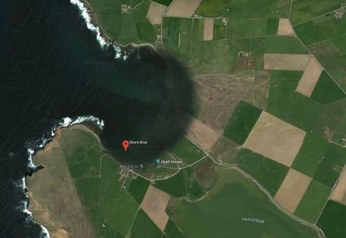
File:Map hypothesis.JPG|Current situation | File:Map hypothesis.JPG|Current situation. ''The map based on Google Maps.'' | ||
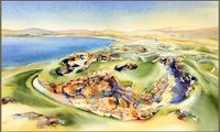
File:Map hypothesis1.jpg|Hypothesis for this landscape. Due to the climate change and coastal erosion issues, this precious heritage site may be washed away, the zone may be covered by water. | File:Map hypothesis1.jpg|Hypothesis for this landscape. Due to the climate change and coastal erosion issues, this precious heritage site may be washed away, the zone may be covered by water.''The map based on Google Maps.'' | ||
</gallery> | </gallery> | ||
Revision as of 17:20, 15 April 2018
>>>back to working groups overview
| Area | Bay of Skaill | |
| Place | Orkney Mainland | |
| Country | Scotland, UK | |
| Topics | Orkney World Heritage Sites and coastal erosion | |
| Author(s) | Anna Ilyuchshenko | |

| ||
Rationale
Skara Brae is the most well-preserved European settlement of the Neolithic Age, discovered at the Bay of Skaill on the west coast of Mainland, Orkney Islands, Scotland. The monument is included in the UNESCO World Heritage List and has a great value for human history reconstruction. This large settlement consists of 8 stone-built clustered houses, which were inhabited in the period of approximately 3100-2500 BC, which makes it even older than Stonehenge and the Great Pyramids. Proximity of the coastline is a threat to this monument, likely some of the ancient structures were already swallowed up by the sea.
Location and scope
You can edit this map with the map editor
A Landscape System Analysis
A.1 Landscape layers and their system context
Geomorphology, landscape units and coastal typology
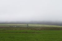
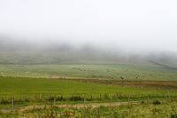
Except the sandy Bay of Skaill, the coast consists of cavernous cliffs of Stromness flagstones, Middle Old Red Sandstones of Orkney. The Orkney landscape is mostly open, low lying with smooth relief. The lack of diversity occurs in landscape types of features. The typology include two main features - a large flat arable land and a hilly ground.
-
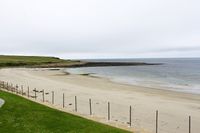 the Bay of Skaill shoreline
 -
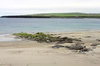 the Bay of Skaill shoreline


Land use
The biggest part of Orkney land use consists of planned rectilinear fields and farms. Near 60 per cent of the total area is farmland with grassland and arable crops. The rest of the area is mostly moorland, but also includes development areas, coastal areas and lowland nature reserves. The agricultural economy is based on rearing livestock, dairy cattle, production of beef, lamb and wool. The most distinctive feature of the agricultural landscape is its improved pasture. Agriculture was always the most prevalent way in which humans have managed the landscape of Orkney. There is no significant forces capable to change the situation.
-
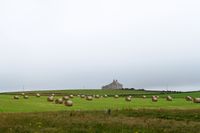 Farmland
 -
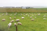 Pasture
 -
 Farmland
 -
 Grassland


Green/blue infrastructure
The major potential elements of a green and blue infrastructure network of the area are continuous monotonous fields and pastures, a lake and the sea itself. Nowadays, there is no significant prerequisites for drastic changes of green and blue infrastructure network.
-
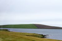 Blue infrastructure
 -
 Green infrastructure


Actors and stakeholders
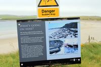
Mostly, this area meets an undeniable threat from climate change. The driving changes in this landscape are quickly rising sea level, coastal erosion and severe weather conditions. The affected zones by the climate change are precious historical sites, such as Skara Brae and several others. The map below shows main actors and stakeholders, who could affect the situation.
-
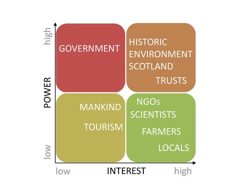 Power map

Sacred spaces and heritage
The most valuable site in this area is the famous, one of the best preserved Stone Age villages in the world - Skara Brae. It has not only a great value to the local economy, but also an outstanding universal significance.
-
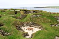 Skara Brae, historical site
 -
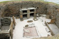 Skara Brae
 -
 Threat


Visual appearance and landscape narrative
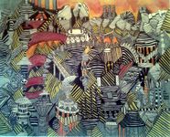
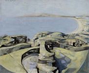
According to the Land Use Consultants in Scottish Natural Heritage Review No 100, "the monotonous continuity of fields and the tapestry of greens and yellows is a dominant image of the landscape. Low sunlight often exaggerates the colors and textures of these fields. Spring grass growth in particular can appear as a vivid green blanket". The Orkney landscape was painted and described countless of times by Scottish painters and writers and others. However, our interest is on the historical site Skara Brae. The village was uncovered by a storm in 1850, therefore there is more modern art which shows the landscape of the site. Some paintings are represented below. Besides painting, Skara Brae was mentioned in several books, such as "The Boy with the Bronze Axe" by Kathleen Fidler, "Shifting Sands" by Rosemary Sutcliff, "A History of the Twentieth Century" by Kim Stanley Robinson. A reference to Skara Brae was even made in the film "Indiana Jones and the Kingdom of the Crystal Skull". Jones is shown lecturing to his students about this historical site.
-
 SKARA BRAE, Gregg Allan McGivern
 -
 SKARA BRAE ORKNEY, Jonathan Wheeler
 -
 SKARA BRAE, Michael Ayrton
 -
![SKARA BRAE [Abstract N° 1847], Koen Lybaert](/images/thumb/c/cf/Koen_Lybaert.JPG/124px-Koen_Lybaert.JPG) SKARA BRAE [Abstract N° 1847], Koen Lybaert
SKARA BRAE [Abstract N° 1847], Koen Lybaert


![SKARA BRAE [Abstract N° 1847], Koen Lybaert](/index.php?title=File:Koen_Lybaert.JPG)
A.2 Summary of you landscape system analysis and your development Targets
Which goals are at risk?
- What is your hypothesis for this landscape?
- Visualise your hypothesis with one graphic/pict
- Are there any existing initiatives taking action in this landscape? Do you have a critical perspective on that?
- Add text and visuals
-
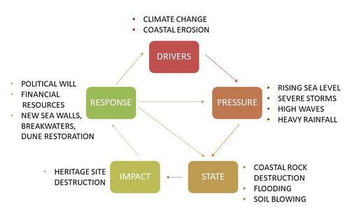 The figure shows the main drivers, possible pressure and state of the environment, future consequences and potential steps for problem solving.

-
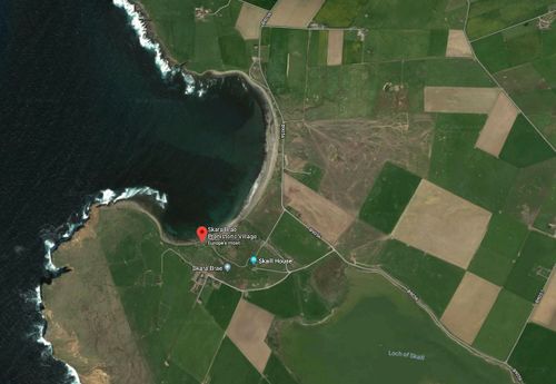 Current situation. The map based on Google Maps.
 -
 Hypothesis for this landscape. Due to the climate change and coastal erosion issues, this precious heritage site may be washed away, the zone may be covered by water.The map based on Google Maps.


A.3 Theory reflection
- Reflect on at least three international policy documents in relation to their local landscape case
- choose one international, one European and one national document
- You can choose references from our reading list
- Scope: 250 words
A.4 References
- give a full list of the references you have used for this section
http://earthwise.bgs.ac.uk/index.php/Middle_Old_Red_Sandstone_of_Orkney,_Stromness_Flags
Land Use Consultants 1998. Orkney landscape character assessment. Scottish Natural Heritage Review No 100.
Phase B: Landscape Evaluation and Assessment
B.1 Assessment Strategy
- Based on the hypothesis derived from your previous landscape systems analysis you are now asked to define the goals for assessing the landscape. Your assessment is the basis for evaluating the landscape status.
- Which elements and phenomena need to be mapped, why and how?
- This a text contribution, max 250 words
B.2 Mapping
- As defined by your assessment strategy you conduct the mapping and present your findings here
- As a minimum, at least three different themes need to be mapped, you may choose more if needed
-
briefly explain the findings of your mapping
-
briefly explain the findings of your mapping
-
briefly explain the findings of your mapping
B.3 Problem definition and priority setting
- Give a summary of the major findings of your mapping process, what are the problems/potentials identified?
- Draw a problems/potentials map
- Set priorities for the most relevant issues
-
add caption here
B.4 Theory reflection
- Please reflect the assessment and evaluation methods used based on at least three readings
- Did you encounter limitations'
- 200 words test contribution
B.5 References
- give a full list of the references you have used for this section
Phase C – Strategy and Master Plan
C.1 Goal Setting
- Define strategic planning objectives based on the evaluation findings
- Link back to your original targets from section one and the Development Goals
- 150 words text contribution
C.2 Spatial Strategy and Transect
- translate your strategic goals into a vision
- develop a spatial translation of your vision
- exemplify your vision in the form of a transect with concrete interventions
- add map(s) and visualizations
-
add caption here
-
add caption here
-
add caption here
-
add caption here
C.3 From Theory of Change to Implementation
- For implementing your vision: Which partnerships are needed? Which governance model is required?
- Who needs to act and how? Draw and explain a change/process model/timeline
- Which resources are needed? On which assets can you build?
- add 150 words text and visuals
-
add caption here
-
add caption here
C.4 References
- give a full list of the references you have used for this section
D. Process Reflection
- Reflect in your intercultural and interdisciplinary team on the outcomes of your study
- Which limitations were you facing?
- What have you learnt from each other?
- What would you do differently next time?
- You can also use diagrams/visuals
- 250 words text