COLAND Case Study 2020 - Bray-Dunes: Difference between revisions
Nicole.leung (talk | contribs) |
Anna.volken (talk | contribs) |
||
| Line 70: | Line 70: | ||
=== Green/blue infrastructure === | === Green/blue infrastructure === | ||
* | * The blue infrastructure is first represented by the sea, of course, but in this area there are also the presence of wetlands (they continue after the Belgium border - in De Panne waters) and a canal between communes. | ||
* | * In the green infrastructure the two most common elements are grasslands between the urban area and the international border, and crop fields in the border with the other French commune - Ghyvelde. | ||
* | * Relevant in the area is the National Nature Reserve of the Dune Marchand, a natural and diverse environment in constant evolution. The reserve is exceptional on an ecological level, however also very fragile: repeated tramplings threaten the species of varied flora, birds and amphibians. (Also a Protected area Natura 2000) | ||
<gallery caption=" " widths="200px" heights="150px" perrow="5"> | <gallery caption=" " widths="200px" heights="150px" perrow="5"> | ||
File: | File:Blue_infrastructure_braydunes.png|''North Sea, a canal following the commune border and wetlands in the sea line'' | ||
File: | File:Green_infrastructure_braydunes.png|''Predominance of natural grassland around the urban area and crops near the commune border'' | ||
</gallery> | </gallery> | ||
Revision as of 11:15, 29 February 2020
>>>back to working groups overview
| Area | Hauts-de-France | |
| Place | Bray-Dunes | |
| Country | France | |
| Topics | Transboundary area, Coastal landscape, Nature and Heritage preservation, Tourism attraction | |
| Author(s) | Wasiliki Moreno, Arati Uttur, Raphaela Roming, Ho Ching Leung, Anna Fernanda Volken, Anca Strugariu | |

| ||
Rationale
The first keyword is dynamic, in terms of the protected landform and high biodiversity. In Bray-Dunes right adjacent to the Belgian border there is 250 hectares National Nature Reserve of the Dune Marchand classified in 1974 to protect the dunes of Flanders. The landform possesses high biodiversity of plant species and is home to many land animal and underwater species.
The second key word is memories, reflecting the historical significance of Bray-Dunes. Bray-Dunes was a significant site during World War II, and it is the site of many casualties during the period of Dunkirk evacuation. The physical ruins such as the wrecked Operation Dynamo ships on the Beach at Zuydcoote shape the sentimental atmosphere and give the place significant historical values.
The third word is recreation. Located at the Opal Coast near Belgian border, the seaside of Bray-Dunes offers a long and beautiful fine sand beach that is perfect for both relaxing and sports like sand yachting and speed sailing, making it a popular holiday spots.
Our hypothesis for Bray-Dunes is that Coastal exploration since 20th century is invading the natural ecology and landscape of the coast, together with the increased chance of flooding brought by climate change. Nature dynamics and cultural memories of Bray-Dunes will be destroyed without legit policies on coastal protection.
Location and scope
You can edit this map with the map editor
A Landscape System Analysis
A.1 Landscape layers and their system context
Geomorphology, landscape units and coastal typology
The coast of Bray-Dunes is a part of the Dunes de Flandre, a 15-kilometre dune field of fine sandy beach that stretches from Dunkirk to Bray-Dunes. Within the long-stretching dune field, the coastal landscape is characterised by the carved sea ridge dunes and mega-parabolic dunes, with intervals of both high and humid dune slacks and low fossil dunes that started to stack up since 3,000 BC.
The sandbanks and dunes are formed by transportation of fine sediment landward by coastal wind and waves, and further on stabilized with vegetation such as native dune grass. This forms primary dunes which situated closer to the coast and significantly affected by waves, salt spray and erosion, and secondary dunes which are located further inland and not often directly exposed to marine influences but more prone to urban intrusion.
Coastal landscape further to the south of Bray-Dunes is characterised by polders, the maritime plains with their network of canals, which are patches of low-lying tract of land enclosed by embankments of dikes.
Currently the rapid urbanisation, water extraction and intensification of agriculture in zones between dunes and polders have resulted in the overgrowth of dune landscape by scrub.
-
 15-km coast of Dunes de Flandre stretching from Dunkirk to Bray-Dunes
 -
 Sandbanks and primary dunes near the coast
 -
 Diagram showing the formation of sand dunes


Land use
- settlements, infrastructure, agriculture, resource extraction, natural areas, energy production...
- description of evolution, status quo and driving forces, is the land use likely to change? Why is that? (approx 200 signs)
- add 1-2 graphical representations to the image gallery, you can add more if you like
-
add a caption
-
add a caption
-
add a caption
Green/blue infrastructure
- The blue infrastructure is first represented by the sea, of course, but in this area there are also the presence of wetlands (they continue after the Belgium border - in De Panne waters) and a canal between communes.
- In the green infrastructure the two most common elements are grasslands between the urban area and the international border, and crop fields in the border with the other French commune - Ghyvelde.
- Relevant in the area is the National Nature Reserve of the Dune Marchand, a natural and diverse environment in constant evolution. The reserve is exceptional on an ecological level, however also very fragile: repeated tramplings threaten the species of varied flora, birds and amphibians. (Also a Protected area Natura 2000)
-
 North Sea, a canal following the commune border and wetlands in the sea line
 -
 Predominance of natural grassland around the urban area and crops near the commune border


Actors and stakeholders
- Environmental partners and scientists can affect in the planning and management of a sustainable coastal landscape, the most affected groups include: community, land owners, marine occupations.
- Media, Government-authorities and maritime need to be kept satisfied.
- Industry and education require the least effort, while key players are: Regulators, investors, NPOs-NGOs, Tourists and cross border cooperations.
-
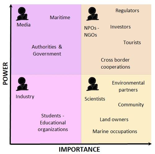 Stakeholders of Bray Dunes

Sacred spaces and heritage
- Which places/elements hold cultural value and to whom?
- You may add a map and some images, please also explain in your caption why these elements are valuable
-
add a caption
-
add a caption
-
add a caption
Visual appearance and landscape narrative
- Which elements are essential for the landscape character?
- Has the landscape been painted or otherwise depicted, when and whom? Which elements are essential?
- Which narratives exist? Who has written about this landscape or depicted it in some way?
- You can add text and images
-
add a caption
-
add a caption
-
add a caption
A.2 Summary of your landscape system analysis and your development targets
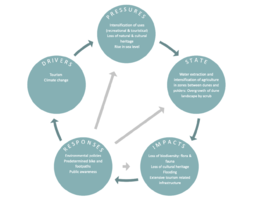
- You can summarize your findings with an DPSI(R) Model or a Spider Diagram
- Link back to the Sustainable Development Goals: Which goals are at risk?
- What is your hypothesis for this landscape?
- Visualise your hypothesis with one graphic/pict
- Are there any existing initiatives taking action in this landscape? Do you have a critical perspective on that?
- Add text and visuals
-
 explain your analysis briefly in the caption

-
 The extreme scenario represents the climate change forces creating a huge flooding problem. The sustainable scenario with the new green zone design plans shows the changes after a 20-50 years period. Nothing changes much (as nothing changed much the last 50 years) except from greener areas and more tourism.

A.3 Theory reflection
- Reflect on at least three international policy documents in relation to their local landscape case
- choose one international, one European and one national document
- You can choose references from our reading list
- Scope: 250 words
A.4 References
- https://www.dunkirk-tourism.com/What-to-see-do/Nature/Les-Dunes-de-Flandre-nature-reserve
- https://ch.oui.sncf/fr/article/les-dunes-de-flandre
- http://www.conservatoire-du-littoral.fr/TPL_CODE/TPL_UNITELITTORAL/PAR_TPL_IDENTIFIANT/101/125-les-paysages-fiche.htm
- https://land.copernicus.eu/local/urban-atlas
- https://www.openstreetmap.org/#map=13/51.0615/2.5126&layers=C
- https://www.google.com/search?q=bray+dunes+camping+municipal&npsic=0&rflfq=1&rlha=0&rllag=51077997,2538343,1019&tbm=lcl&ved=2ahUKEwjp4pWf8trnAhUSilwKHY6bDw0QtgN6BAgLEAQ&tbs=lrf:!3sIAE,lf:1,lf_ui:4&rldoc=1#rldoc=1&rlfi=hd:;si:,51.080248504007805,2.582632035253937;mv:[[51.102674420897195,2.6052913370117494],[51.03093797609536,2.413717240332062],null,[51.066820095899374,2.5095042886719057],13]
- http://sentierdunord.free.fr/Circuit%20de%20la%20dune%20marchand%20zuydcoote.html
- http://escapadenature-sansvoiture.fr/les-escapades-nature-sans-voiture/dunes-flandre
- https://fr.wikipedia.org/wiki/R%C3%A9serve_naturelle_nationale_de_la_dune_Marchand#/media/Fichier:P%C3%A9rim%C3%A8tre_RNN_Dune_Marchand_rnn19.png
- http://www.reserves-naturelles.org/dune-marchand
- https://www.openstreetmap.org/
- https://www.flickr.com/
- https://www.dunkerque-tourisme.fr/
- https://www.artmajeur.com/
- https://www.mutualart.com/
- https://www.ateliers.org/media/workshop/documents/atelier_dunkerque_presentation_en.pdf
- https://www.wikidata.org/wiki/Q391365
- https://www.cleanpng.com/
Phase B: Landscape Evaluation and Assessment
B.1 Assessment Strategy
- Based on the hypothesis derived from your previous landscape systems analysis you are now asked to define the goals for assessing the landscape. Your assessment is the basis for evaluating the landscape status.
- Which elements and phenomena need to be mapped, why and how?
- This a text contribution, max 250 words
B.2 Mapping
- As defined by your assessment strategy you conduct the mapping and present your findings here
- As a minimum, at least three different themes need to be mapped, you may choose more if needed
-
briefly explain the findings of your mapping
-
briefly explain the findings of your mapping
-
briefly explain the findings of your mapping
B.3 Problem definition and priority setting
- Give a summary of the major findings of your mapping process, what are the problems/potentials identified?
- Draw a problems/potentials map
- Set priorities for the most relevant issues
-
add caption here
B.4 Theory reflection
- Please reflect the assessment and evaluation methods used based on at least three readings
- Did you encounter limitations'
- 200 words test contribution
B.5 References
- give a full list of the references you have used for this section
Phase C – Strategy and Master Plan
C.1 Goal Setting
- Define strategic planning objectives based on the evaluation findings
- Link back to your original targets from section one and the Development Goals
- 150 words text contribution
C.2 Spatial Strategy and Transect
- translate your strategic goals into a vision
- develop a spatial translation of your vision
- exemplify your vision in the form of a transect with concrete interventions
- add map(s) and visualizations
-
add caption here
-
add caption here
-
add caption here
-
add caption here
C.3 From Theory of Change to Implementation
- For implementing your vision: Which partnerships are needed? Which governance model is required?
- Who needs to act and how? Draw and explain a change/process model/timeline
- Which resources are needed? On which assets can you build?
- add 150 words text and visuals
-
add caption here
-
add caption here
C.4 References
- give a full list of the references you have used for this section
D. Process Reflection
- Reflect in your intercultural and interdisciplinary team on the outcomes of your study
- Which limitations were you facing?
- What have you learnt from each other?
- What would you do differently next time?
- You can also use diagrams/visuals
- 250 words text