COLAND Case Study 2020 - Ostend: Difference between revisions
Undo revision 10061 by Chismorie.almond (talk) Tag: Undo |
|||
| Line 301: | Line 301: | ||
== C.4 References == | == C.4 References == | ||
https://bonjourlafrance.com/travel/belgium/flanders/ostend/train-stations/ostend-train-station/, date 19.03.2020; | |||
https://www.blocal-travel.com/world/belgium/oostende/ostend-street-art-guide/, date 19.03.2020; | |||
= D. Process Reflection = | = D. Process Reflection = | ||
Revision as of 19:09, 19 March 2020
>>>back to working groups overview
| Area | Workgroup 7: Ostend | |
| Place | De Panne | |
| Country | Belgium | |
| Topics | Coastal Line Study, Understanding Coastal Landscapes, Evaluation and Assessment for Coastal Landscapes Integrated Planning and Design for Coastal Landscape | |
| Author(s) | Chismorie Almond Edgar David, Delia Laura Maria, Gonțilă Larisa-Cristina, Neculai Raluca-Elena, Trifan Loredana-Andreea, Pătrășcu Paula Silvia, Popa Maria-Andreea | |

| ||
Rationale
Keywords: urban area, diversity, historical background, strategic position, mix between old and new, area as a palimpsest
Ostend area was very important for the strategic position on the North Sea coast, having a complex history and evolution regarding all the layers of its system in the last centuries, becoming now an important urban pole nearby the coast. The erosion of the coast, heavy rainfall, storms and rising sea level due to climate change are the main challenges for the area, making it vulnerable. Moreover, the tourism is not controlled, and the area can soon be on the list of over-touristed cities.
The study case is structured in three steps: landscape system analysis (understand the coastal landscape and its layers that make a complex system), landscape evaluation and assessment (critically understand the strengths, weaknesses, opportunities and threats leading to a diagnostic of the area) and finally strategy and master plan, a vision, a proposal, an integrated planning and design for coastal landscapes (projects and directions of intervention to protect and highlight the main characteristics of the zone, while looking to ameliorate the problems).
Location and scope
You can edit this map with the map editor
A Landscape System Analysis
A.1 Landscape layers and their system context
Geomorphology, landscape units and coastal typology
The geomorphology evolution starts with the Ostend valley which was formed in the course of the Saale ice age, when the North Sea was a dry land crossed by large rivers that deposited sediments in the valleys. During the warmer Eemian interglacial period, the sea level rose and the Ostend valley was transformed into an estuarine area, influenced by tides. Around 7000 BC the sea level stabilized and a dune barrier was formed, which prevented the land from frequent flooding. During the Roman era the sea was located only a few kilometers offshore from today`s coastline, the sandy dunes made a stronger border between the sea and a marsh area crossed by many creeks and tidal gullies. During the Middle Ages, tidal channels and creeks formed many islands, the medieval town of Ostend was part of Testerep island, which was separated from the mainland by the tidal channel called the “Tersterep gully’’. Later in the medieval times, human impact became more present in the evolution of the landscape, people were building dikes in order to protect themselves from flooding. The shoreline retreated over 1 km and in the 16th century the old town of Oostende was drowned almost completely, after this point the present coastline was more or less reached.
The landscape is influenced by the biggest urban area of Belgian coast - the city of Ostend which is developed above a land corridor with higher altitude, that separate the North Sea from the low altitude inland plains which sometimes are below the sea level. A common landscape unit for these corridors are the dunes and the most important of them here, are the Dunes of Bredene. From the beginning of the 17th century dates the 24.6km long Bruges - Ostend Canal which connects the city of Bruges with the North Sea and forms on the intersection a small estuary.
Also an important unit is Spuikom, an artificial pond used as a drainage basin built in order to keep the harbor channel sufficiently deep. After the First World War the drainage system was destroyed and never repaired again.
The Coastal typology is a tidal system, the coast is stabilized by groins, distributed on intervals ranging from 300m to 400m across the beaches.
-
 The Dunes of Bredene

Land use
Located in the province of West Flanders, Belgium, Ostend is the largest city of the Belgian coast. It has a diverse range of population of approximate 70,000, of which 20% are aged 65 and over (dates from 2019). Historically, it has been under the domination of various empires due to it’s strategic position on the North Sea and served as a major German submarine base or a coastal fortress in both World Wars.
In the present, based on its position on the North Sea, Ostend uses its wave and offshore wind potential to produce renewable energy.
In regard to connectivity and transport, Ostend benefits of good accessibility both nationally and internationally. It is well connected to Bruxelles, the rest of the country and internationally through various national roads, railway and flights as it comprises a big rail station and an international airport - Oostend - Bruges.
The city has a structured system of activities comprising various seaside related activities (tourism and leisure, industrial, transport - general cargo, ferry port, etc) and cultural activities for locals.
-
 Green areas
 -
 Ladscape use and circulation


Green/blue infrastructure
Green/blue infrastructure network is a natural and semi-natural network that provides services to humans and since early Middle Ages, Ostende was a small village built on the east-end of the island between the North Sea and a beace lake where the main source of income for the citizens was fishing.The complex blue infrastructure it’s the most important part which keeps the city alive so the grey and green/blue parts of this city have to corelate and co-exist with eachother.
The city is built according to the watercourse and we can observe the respect for nature through the main nature attractions; Leopold Park; Maria Hendricka Park;Green Bridge science Park; North Sea Aquarium and of course the principal Plage d’Ostende and the ‚collector’ lake Spuikom. This area is characterized by equable climates with few extremes of temperature and ample precipitation in all months. It is located poleward of the Mediterranean climate region on the western sides of the continents, between 35° and 60° N and S latitude. Because the main animals found in the area are fish (eg. Garfish; Brill; Herring; Flounder) there is a big population and diversity of costal-birds such as Great cormorant; Sandwich tern; Black-headed Gull; Grebes and in the parks we can find Mute swan or Black swan. If we are lucky we cand also see some of the marin mammals like White-beaked dolphins and Seals.


Actors and stakeholders
An important category of stakeholders represents the administration sphere, the municipality and different organizations, having a high level of interest and moderate means of action. The main stakeholder with the highest interest and power in the area is the Flemish agency for Maritime Services and Coast, given the importance and role of the Ostend as a key component in the costal system. A direct relationship is formed with the local interested parts. The residents, fishermen, tourists, investors and business owners are considered playing a key role at local scale and having a crucial part in the eco-social and environmental situation of the area. Between all the stakeholders there is a relationship of codependency, influencing one another, improving and promoting the right kind of development for the city.
-
 The power map of stakeholders

Sacred spaces and heritage
In translation, the city of Ostend means East –End (oost - einde). Ostend was a small fishing village of about 3,000 inhabitants, founded five hundred years ago. The village rose to the status of "town" around 1265, when the inhabitants were allowed to hold a market and to build a market hall. The strategic position on the North Sea coast had major advantages for Ostend as a military port and aharbour. The town was frequently taken, ravaged, ransacked and destroyed by conquering armies. The town was frequently taken, ravaged, ransacked and destroyed by conquering armies. After the memorable siege, during the Eighty Years' War and the Anglo–Spanish War, Ostend was turned into a harbour, provided an important alternative exit to the sea, in the 1722, and today this city is the largest coastal city of Belgium.
Ostend is a city with a rich history, with military, maritime and cultural heritage.
- Ostend’s Raversyde neighborhood has been left with one of the best preserved remnants of the immense German Second World War coastal defense, the Atlantic Wall, an extensive system of coastal defence and fortifications built by Nazi Germany between 1942 and 1944, along the coast of continental Europe and Scandinavia. This structure is made up of two kilometers of tunnels and trenches, 60 bunkers, as well as observation posts and gun positions.
- Sint-Petrus-en-Pauluskerk (Church of Saint Peter and Saint Paul), the main church of Ostend, is a Roman Catholic Neo-Gothic church. It is built on the ashes of a previous church that occupied the site. King Leopold II supported the plan to build a new one. Construction started in 1899 and was completed and consecrated by Bishop Waffelaert on August 31, 1908.
- In 18th century, Napoleon feared an attack from England, and therefore build an impressive fort in the dunes in 1811. The attack never happened, but in both world wars the fort serves it purpose for artillery used by the German army. After it became a museum and now it is a children's playground.
- The lost fishing settlement of Walraversijde is one of the most important archeological sites in Flanders with four reconstructed fishermen’s dwellings.
-
 Map 1775
 -
 Atlantic Wall 1942 - 1944
 -
 Atlantic Wall Museum
 -
 Field Marshal Erwin Rommel visiting the Atlantic Wall defences near the Belgian port of Ostend
 -
 Ostende Map - Attractions
 -
 Sint-Petrus-en-Pauluskerk
 -
 Fort Napoleon
 -
 ANNO 1465 Raversyde


Visual appearance and landscape narrative
The characteristics of the land were modeled by nature and men, the costal landscape remained an iconic part of the setting, whilst the city changed facing numerous hardships such as war. The perception of the city has been contoured during its entire evolution resulting in a distinctive image. The town interweaves the sea landscape with the urban development without losing its identity as a key harboring point. An important aspect of Ostend all throughout history is the culture and personalities it hosted as a place of creation when it was a fashionable outing for royalty and aristocracy. Among the residents that captured the essence and were inspired by the city were the painters James Ensor, Gustaaf Sorel, Roger Remaut, the writer Karel Jonckheere and musician Marvin Gaye.
In return, the city was immortalize in paintings, portraying the sea and the beauty of life, writings, depicting the hardships of World War I and World War II, and in later years in movies or documentaries. The most illustrated subjects are the costal landscape, the sea, the harbor, the beach and the promenade along the shore. In the passing of time, all this elements represent the history of the place and combined create the social identity on which the city developed and is identifiable on local and global scale. Ostend is well known for artists under the name “Ensors” town, because of the renowned painter James Ensor. A beautiful description of the essence of this city is “…Ostend also conjures up memories of bursts of energy, and intensity and strength, of a new beginning with the force of a catapult…”, found in the book Summer Before the Dark: Stefan Zweig and Joseph Roth, Ostend 1936 by Volker Weidermann.
-
 The Siege of Ostend 1601-1604 by Peter Snayers
 -
 Ostend Seaside by James Ensor
 -
 The trading docks in Ostend by Gustaaf Sorel
 -
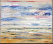
 The beach at Ostend by Lemmen Georges


A.2 Summary of you landscape system analysis and your development Targets
For system analysis of the area of Ostend, a DPSIR Framework is used. The development of a tertiary service economy and other related sectors such as tourism development and residential development and the population growth, due to the transformation of Ostende- a fisher village into a harbour and now also as a seaside reasort are the major drivers forces.
The main pressure is recognized as a human pressure: construction of coastal infrastructures due to Ostend’s strategic position, growth of city of Ostend, the activities such as motor boarding, fishing, diving and exploitation of land and the present rate of gas emission and climate changes. Coastal urbanization, artificialisation of the coast and soil, the rise in the level of the North Sea are causes of the present state: change in the coastal landscape, which represent a threat of the natural and build heritage.
The spatial impacts of the coastal landscape are inequalities in development, destruction of heritage and ecosystem disturbance which threathen the biodiversity and the life of the residents of Ostend. Despide that fact, measures to mitigate or correct these dysfunctions observed exists: environmental policies and land-use policies and consistent actions such as raising various beaches, protecting the entrances of the ports and building walls designed to break the force of the waves. For this, the cooperation of stakeholders is needed: involvement of residents, organisations, municipality, agencies and investors.
-
 DPSIR Framework is used for system analysis of the area. A holistic approach to integrated development is a necessary response, which includes various steps for recognizing and conserving the values of the area.

At the current state fragmentation of landscapes and ecosystems, climate changes and incoherent development are leading the area to lose of environmental and cultural heritage, the rising of the sea level, biodiversity loss, acceleration of the urbanization phenomenon and also reduced quality life, safety for locals in Ostend and satisfaction of tourists.
Development targets are oriented towards protecting the ecosystem, reducing the environmental impact of human activities, preserving the coastal landscape, protecting the heritage , coherent future development and improving Ostend’s image and quality of life of residents and tourists. Involving the people, both as individuals and as groups in preserving the coastal landscape, increasing awareness and sustained actions of stakeholders are essential in achieving these targets.

A.3 Theory reflection
- National document
Belgian National Adaptation Plan 2017 - 2020
The National Climate Committe members of the federal and regional (Flanders, Wallonia and Brussels) gouvernments built this plan in order to cover all the areas influenced by climate change. Extensive links between different policy areas and thei adaptation efforts will lead to synergies and could further avoid maladaption, finally leading to a coherent adaptation policy.
Ostend area, due to the coastal landscape and the vulnerability to climate change needs to have a plan to adapt to this changes: to build capacity and anticipate and mitigate risks and maximize the potential benefits of climate change. The 6th (evaluate the impact of climate change on the security of the energy supply and the energy transport and distribution infrastructures) and 7th (evaluation of the socio-economic impacts of change in Belgium) measure of this document have a direct influence on the study area.
- European document
European Commission Marine Strategy Framework Directive
The aim of “Marine Strategy Framework Directive” is to protect more effectively the marine environment across Europe and to achieve GES (Good Environmental Status) of the EU’s marine waters by 2020 and to protect the resource base upon which marine-related economic and social activities depend. This is the first EU instrument related to this topic.
Climate change is affecting the marine environment and will continue to modify the layers of the maritime coastal landscape, flora and fauna. Marine strategies in some coastal areas (including Ostend) will need to identify ways of adapting to the effects of global warning and to reduce the vulnerability.
- Intenational document
UN HABITAT Guiding Principles for City Climate Action Planning
The Guiding Principles for City Climate Action Planning reviews typical steps in the city level climate action planning process in light of a proposed set of globally applicable principles (city climate action planning should be: ambitious, inclusive, fair, comprehensive and integrated, relevant, actionable, evidence-based, transparent and verifiable).
The Guiding Principles are aimed primarily at city-level actors (local officials, local planners, local stakeholders), in order to guide and help the cities and their supporting partners in their efforts to tackle the climate challenge in the coherent way.
A.4 References
http://archmanche.maritimearchaeologytrust.org/uploads/images/Documents/Technical_Report_Section_3L.pdf, date 20.02.2020;
https://www.climat.be/files/4214/9880/5755/NAP_EN.pdf, date 20.02.2020;
https://ec.europa.eu/environment/marine/eu-coast-and-marine-policy/marine-strategy-framework-directive/index_en.htm, date 20.02.2020;
https://unhabitat.org/guiding-principles-for-climate-city-planning-action, date 20.02.2020;
https://www.the-low-countries.com/article/ostend-a-sea-change, date 20.02.2020;
https://www.matchup-project.eu/news/smart-solutions-for-over-touristed-cities/, date 20.02.2020;
https://www.portofoostende.be, date 20.02.2020;
https://www.reboostende.be, date 20.02.2020;
https://www.oostende.be, date 20.02.2020;
https://climate-adapt.eea.europa.eu/metadata/publications/national-adaptation-strategy-belgium, date 20.02.2020;
https://en.wikipedia.org/wiki/Ostend, date 20.02.2020;
https://en.wikipedia.org/wiki/Siege_of_Ostend, date 20.02.2020;
https://www.portofoostende.be/, date 20.02.2020;
https://en.wikipedia.org/wiki/Ostend, date 20.02.2020;
https://www.citypopulation.de/en/belgium/westvlaanderen/oostende/35013__oostende/, date 20.02.2020;
https://www.portofoostende.be/activity/industrial-area, date 20.02.2020;
https://www.portofoostende.be/activity/innovation-development, date 20.02.2020;
source https://www.britannica.com/event/World-War-II, date 20.02.2020;
J.E Kaufmann,The Atlantic Wall: History and Guide, 2012;
https://en.wikipedia.org/wiki/Atlantic_Wall, date 20.02.2020;
https://en.wikipedia.org/wiki/Siege_of_Ostend#/media/File:Sitio_de_Ostende.jpg, date 20.02.2020;
https://www.haroldtkint.com/objectdetails/789064/0/0/james-ensor-ostend-belgium-1860-ostend,date 20.02.2020;
https://www.britannica.com/place/Ostend, date 20.02.2020;
https://www.poeticous.com/william-lisle-bowles/the-bells-of-ostend, date 20.02.2020;
https://www.akg-images.co.uk/archive/The-beach-at-Ostend-2UMDHUR67L8E.html, date 20.02.2020;
https://www.iala-aism.org/organisation/agency-for-maritime-services-and-coast-flemish-government/, date 20.02.2020;
https://www.portofantwerp.com/en/flemish-agency-maritime-services-and-coast, date 20.02.2020;
V. Weidermann, Summer Before the Dark: Stefan Zweig and Joseph Roth, Ostend 1936, 2016, date 20.02.2020;
http://www.sacred-destinations.com/belgium/ostend-st-petrus-en-paulus-kerk, date 20.02.2020;
https://www.planetware.com/belgium/bruges-surroundings-b-wv-bgsur.htm#B-WV-OOO, date 20.02.2020;
https://oostende.org/en/monument/9830/fort-napoleon.html, date 20.02.2020;
Phase B: Landscape Evaluation and Assessment
B.1 Assessment Strategy
- Based on the hypothesis derived from your previous landscape systems analysis you are now asked to define the goals for assessing the landscape. Your assessment is the basis for evaluating the landscape status.
- Which elements and phenomena need to be mapped, why and how?
- This a text contribution, max 250 words
B.2 Mapping
- As defined by your assessment strategy you conduct the mapping and present your findings here
- As a minimum, at least three different themes need to be mapped, you may choose more if needed
-
briefly explain the findings of your mapping
-
briefly explain the findings of your mapping
-
briefly explain the findings of your mapping
B.3 Problem definition and priority setting
- Give a summary of the major findings of your mapping process, what are the problems/potentials identified?
- Draw a problems/potentials map
- Set priorities for the most relevant issues
-
add caption here
B.4 Theory reflection
- Please reflect the assessment and evaluation methods used based on at least three readings
- Did you encounter limitations'
- 200 words test contribution
B.5 References
- give a full list of the references you have used for this section
Phase C – Strategy and Master Plan
C.1 Goal Setting
- Define strategic planning objectives based on the evaluation findings
- Link back to your original targets from section one and the Development Goals
- 150 words text contribution
C.2 Spatial Strategy and Transect
- translate your strategic goals into a vision
- develop a spatial translation of your vision
- exemplify your vision in the form of a transect with concrete interventions
- add map(s) and visualizations
-
add caption here
-
add caption here
-
add caption here
-
add caption here
C.3 From Theory of Change to Implementation
- For implementing your vision: Which partnerships are needed? Which governance model is required?
- Who needs to act and how? Draw and explain a change/process model/timeline
- Which resources are needed? On which assets can you build?
- add 150 words text and visuals
-
add caption here
-
add caption here
C.4 References
https://bonjourlafrance.com/travel/belgium/flanders/ostend/train-stations/ostend-train-station/, date 19.03.2020; https://www.blocal-travel.com/world/belgium/oostende/ostend-street-art-guide/, date 19.03.2020;
D. Process Reflection
- Reflect in your intercultural and interdisciplinary team on the outcomes of your study
- Which limitations were you facing?
- What have you learnt from each other?
- What would you do differently next time?
- You can also use diagrams/visuals
- 250 words text