COLAND Case Study 2020 - Bray-Dunes: Difference between revisions
Anna.volken (talk | contribs) |
Anna.volken (talk | contribs) |
||
| Line 390: | Line 390: | ||
<gallery caption=" " widths="500px" heights="200px" perrow="1"> | <gallery caption=" " widths="500px" heights="200px" perrow="1"> | ||
File: | File:CO-LAND_Group_3_Presentation_3_-_Planning_and_Design.jpg|''add caption here'' | ||
== C.2 Spatial Strategy and Transect == | == C.2 Spatial Strategy and Transect == | ||
Revision as of 16:55, 7 April 2020
>>>back to working groups overview
| Area | Hauts-de-France | |
| Place | Bray-Dunes | |
| Country | France | |
| Topics | Transboundary area, Coastal landscape, Nature and Heritage preservation, Tourism attraction | |
| Author(s) | Wasiliki Moreno, Arati Uttur, Raphaela Roming, Ho Ching Leung, Anna Fernanda Volken, Anca Strugariu | |

| ||
Rationale
The first keyword is dynamic, in terms of the protected landform and high biodiversity. In Bray-Dunes right adjacent to the Belgian border there is 250 hectares National Nature Reserve of the Dune Marchand classified in 1974 to protect the dunes of Flanders. The landform possesses high biodiversity of plant species and is home to many land animal and underwater species.
The second key word is memories, reflecting the historical significance of Bray-Dunes. Bray-Dunes was a significant site during World War II, and it is the site of many casualties during the period of Dunkirk evacuation. The physical ruins such as the wrecked Operation Dynamo ships on the Beach at Zuydcoote shape the sentimental atmosphere and give the place significant historical values.
The third word is recreation. Located at the Opal Coast near Belgian border, the seaside of Bray-Dunes offers a long and beautiful fine sand beach that is perfect for both relaxing and sports like sand yachting and speed sailing, making it a popular holiday spots.
Our hypothesis for Bray-Dunes is that Coastal exploration since 20th century is invading the natural ecology and landscape of the coast, together with the increased chance of flooding brought by climate change. Nature dynamics and cultural memories of Bray-Dunes will be destroyed without legit policies on coastal protection.
Location and scope
You can edit this map with the map editor
A Landscape System Analysis
A.1 Landscape layers and their system context
Geomorphology, landscape units and coastal typology
The coast of Bray-Dunes is a part of the Dunes de Flandre, a 15-kilometre dune field of fine sandy beach that stretches from Dunkirk to Bray-Dunes. Within the long-stretching dune field, the coastal landscape is characterised by the carved sea ridge dunes and mega-parabolic dunes, with intervals of both high and humid dune slacks and low fossil dunes that started to stack up since 3,000 BC.
The sandbanks and dunes are formed by transportation of fine sediment landward by coastal wind and waves, and further on stabilized with vegetation such as native dune grass. This forms primary dunes which situated closer to the coast and significantly affected by waves, salt spray and erosion, and secondary dunes which are located further inland and not often directly exposed to marine influences but more prone to urban intrusion.
Coastal landscape further to the south of Bray-Dunes is characterised by polders, the maritime plains with their network of canals, which are patches of low-lying tract of land enclosed by embankments of dikes.
Currently the rapid urbanisation, water extraction and intensification of agriculture in zones between dunes and polders have resulted in the overgrowth of dune landscape by scrub.
-
 15-km coast of Dunes de Flandre stretching from Dunkirk to Bray-Dunes
 -
 Sandbanks and primary dunes near the coast
 -
 Diagram showing the formation of sand dunes


Land use
- The landuse does not change (almost nil) between 2006 to 2018. To support this is a second landuse map from a second source that shows the change from 1965 (!) to 2014. so the change has been gradual over 50 years.The first map shows main landuse is from urban fabric(red) non arable land (light yellow) ; moors and heathland (light green); tidal flats (light purple).
- However, there are several municipal camping areas (marked with red dots) there are many private tourism companies offering bike tours across Dunkirk-BrayDunes-DePanne and there are walking trails in the two natural reserve areas - De la Dune and Marchand. So this indicates that the area is focusing on a lot of tourism related activities. However, there are only two hotels that show up in google maps - and a few airbnbs. In Dunkirk, sand sailing is a dominant sport. I did not find much information about how much it is active in Bray Dunes. Also, there are a few Interreg projects happening here as Bray Dunes is on the border - but the websites are in french. So I have not translated and read them yet.The land south from the railroad that connects Dunkirk , Bray Dunes and De Panne - infact along the whole strip that all case studies are being done - is below sea level and stands the danger of flooding if the sea level rises by 50 cm.
-
 Copernicus maps 2006 to 2018.
 -
 Landuse maps 1965 to 2014.
 -
 Bike trail between Dunkirk and Bray Dunes “circuit de la dune Marchand” with municipal camping sites (in red).
 -
 Bike Trails between De Panne and Bray Dunes - OSM.
 -
 “Le Dunes de Flandre” bike trails between Dunkirk, Bray Dunes and De Panne.
 -
 Marchand Natural Reserve, Bray Dunes.


Green/blue infrastructure
- The blue infrastructure is first represented by the sea, of course, but in this area there are also the presence of wetlands (they continue after the Belgium border - in De Panne waters) and a canal between communes.
- In the green infrastructure the two most common elements are grasslands between the urban area and the international border, and crop fields in the border with the other French commune - Ghyvelde.
- Relevant in the area is the National Nature Reserve of the Dune Marchand, a natural and diverse environment in constant evolution. The reserve is exceptional on an ecological level, however also very fragile: repeated tramplings threaten the species of varied flora, birds and amphibians. (Also a Protected area Natura 2000)
-
 North Sea, a canal following the commune border and wetlands in the sea line
 -
 Predominance of natural grassland around the urban area and crops near the commune border


Actors and stakeholders
- Environmental partners and scientists can affect in the planning and management of a sustainable coastal landscape, the most affected groups include: community, land owners, marine occupations.
- Media, Government-authorities and maritime need to be kept satisfied.
- Industry and education require the least effort, while key players are: Regulators, investors, NPOs-NGOs, Tourists and cross border cooperations.
-
 Stakeholders of Bray Dunes

Sacred spaces and heritage
The site holds onto powerful sacred spaces and heritage. Places and elements, such as the historical features (like cemetery, bunkers, monuments, memorials, ruins), have symbolic meaning and can be found as landmarks along the area. However, maybe the most representative element is the natural one, highlighted by the dunes. The site has two nature reserves: National Nature Reserve of the Dune Marchand which was classified in 1974 and Nature Reserve of the Dune du Perroquet that has a wild dune massif of 250 hectares protected.
On the other hand, the site, viewed from the European Environment Agency’s perspective, The Natura 2000, consists of a network of protected areas covering valuable and threatened species and habitats - a different kind of heritage, one that involves biodiversity and ecosystems.
Regarding the architecture of Bray-Dunes, the villas of the nineteenth century are noticeable, recalling the flourishing age of the resort. Bray-Dunes was also marked by both World Wars, including the Operation Dynamo between May and June 1940. These kinds of elements, sacred places and heritage, hold important cultural value and meaning for the community, as well as for tourists, encouraging and presenting a piece of history.
-
 Places and elements that hold cultural value pinned on a map
 -
 One of the bunkers (historical monuments) along the beach in Bray-Dunes
 -
 Ruins from the operation Dynamo WW2 have great historical importance
_Places_and_elements_that_hold_cultural_value_pinned_on_a_map.png)
_One_of_the_bunkers_(historical_monuments)_along_the_beach_in_Bray-Dunes.png)
_Ruins_from_the_operation_Dynamo_WW2_have_great_historical_importance.png)
Visual appearance and landscape narrative
Landscape character is defined as the distinct, recognisable and consistent pattern of elements in the landscape. It is these patterns that give each locality its 'sense of place', making one landscape different from another. In defining the combinations of components which make each landscape unique, landscape character is a way of thinking about landscape more holistically and objectively, rather than focusing on scenic beauty and subjective responses. Landscapes have evolved over time as a result of both natural and cultural processes.
As mentioned, the site was significant during the World Wars, so many stories and writings are regarding this topic.
We discovered a book, "Het hospitaal van de Koningin - Rode Kruis, L'Océan en De Panne 1914 - 1918" by L. De Munck & L. Vandeweyer, published in 2012. According to the book, indeed WW1 bunkers were built in the region between Bray-Dunes and De Panne, on both sides of the border. In fact, some remaining bunkers on the French side of the border could actually be Belgian bunkers (or at least built under Belgian command).
Despite the historical features, the site is also well appreciated for its aesthetics, so many painters found their inspiration among the area.
In terms of events and festivities, the city of Bray-Dunes, very attached to its culture, offers a great cultural season throughout the year. Regularly, concerts, shows, plays or tales readings are organized for residents. The municipal library often organizes fun and interesting exhibitions. In September, the city opened a portion of its monuments to the public with the European Heritage Days. From late September to early October it is possible to have fun at the fair with rides, an opportunity to spend some time in a charming carnival.
Sport is no exception to Bray-Dunes with the organization of 6h rosalies on the beach in September and the championship coastal archers in the same period. Regularly, guided tours nature of the different dunes of the city are offered by the Tourist Office Bray-Dunes.
-
 Map from the book "Het hospitaal van de Koningin - Rode Kruis, L'Océan en De Panne 1914 - 1918" by L. De Munck & L. Vandeweyer
 -
 The full extend of this region and the details provided on the plan
 -
 “Plage de Bray-Dunes” by Martine Lefèvre
 -
 “Three Sailboats” by Andrew Macara
 -
 “Bray Dunes” by Andrew Macara
_Map_from_the_book_%E2%80%9CHet_hospitaal_van_de_Koningin_-_Rode_Kruis,_L%27Oc%C3%A9an_en_De_Panne_1914_-_1918%E2%80%9D_by_L._De_Munck_%26_L._Vandeweyer.jpg)
_The_full_extend_of_this_region_and_the_details_provided_on_the_plan.png)
_%E2%80%9CPlage_de_Bray-Dunes%E2%80%9D_by_Martine_Lef%C3%A8vre.png)
_%E2%80%9CThree_Sailboats%E2%80%9D_by_Andrew_Macara.png)
_%E2%80%9CBray_Dunes%E2%80%9D_by_Andrew_Macara.png)
A.2 Summary of your landscape system analysis and your development targets
-
 Landscape system analysis - DPSIR Model Bray Dunes

DRIVERS: The Bray dunes are characterized by their natural and cultural heritage. This makes this place very interesting for tourism and related businesses. Therefore, this sector can be determined as the first driving force. Due to their direct influence by the sea the predicted climate change that causes a sea level rise is the second driving force.
PRESSURES: As a result of the focus and the enlargement of the tourism, the place expects greater use and changes in current uses. Recreation and tourist attractions like sailing in the dunes or bike / walking paths can create future pressures. Due to disturbances in this sensitive natural area and installations for tourists the place can also experience a loss of flora and fauna as well as historical heritage. And also because of the climate change a rise in sea level is expected which can be seen as a huge pressure on the site.
STATE: Currently the Bray dunes can be described as an interesting and really valuable site with a lot of natural and cultural heritage. But Water extraction and intensification of agriculture in zones between dunes and polders already caused an overgrowth of the dune landscape by scrub.
IMPACTS: Based on the analyzed influencing factors and changes at the location, the following effects can be expected: A loss of biodiversity (flora & fauna) and cultural heritage, Flooding and an extensive tourism related infrastructure.
RESPONSES: Environmental policies have to come into operation so the protected areas can remain in good condition and we can keep the biodiversity and cultural heritage in the future. Therefore, the paths and trails in the area should be predetermined so there is no trampling in the area that could cause further damage. Public awareness has to be raised so people get to know the value of the place which will then hopefully minimize the problem of garbage and waste.
-
 Landscape system analysis - Hypothesis

The extreme scenario represents the climate change forces creating a huge flooding problem. The assumptions for the area indicates that in a sea level rise of 50cm many places, including inhabited settlements, are in risk of flooding. Even though this is only a theoretical simulation, the land is partly under sea level and may need to adapt to climate change, particularly the possible rise in sea level.
The sustainable scenario, shown on the right side, with the new green zone design plans shows the changes after a 20-50 years period. Nothing changes much (as nothing changed much the last 50 years) except from greener areas and more tourism. In the current planning documents, the environment is a very important part.
A.3 Theory reflection
National Document: Climate Policy in Hauts-de-France
The Hauts-de-France area was characterized by the prominence of heavy industries and an economy based on coal mining, steel production and textile manufacturing. Today only 19% of the population is still working for the industry sector and coal mining was slowly fully replaced by nuclear energy. Currently, nuclear power accounts for 80% of the electricity production in the region but for only 15% of the overall energy consumption, while renewable energy consumption is low compared to the national average (3.7% against 19% in France).
Hauts-de-France intensified its efforts to combat climate change with the adoption of an innovative regional plan bringing together climate, air and energy issues. A 20-year partnership with ADEME (French Environment and Energy Agency) helped the region develop the required expertise and capacity to create and implement impactful projects. With greenhouse gas (GHG) emissions per capita reaching 30% higher levels than the French average and mainly attributed to the industry sector, there is a strong opportunity for Hauts-de-France to develop strategies to reduce emissions.
Climate regional strategy – SRADDT (Stratégie régionale climat) sets an overarching target to divide GHG emissions by 4 by 2050. This strategy is in line with the national commitments embedded in the legislation “Grenelle 2” from 2010. The plan is organized around 4 pillars:
- Improvements of way of life and production methods;
- Continuation of the energy transition;
- Integration of mitigation and adaptation actions in territorial planning; and
- Enhanced governance and participation of local actors.
European Document: The European Water Framework and The Marine Strategy Framework Directives
The European Water Framework (WFD) and Marine Strategy Framework (MSFD) Directives both require EU Member States to take the necessary measures to achieve a good coastal and oceanic environmental status by 2020.
The aim of the European Union's ambitious Marine Strategy Framework Directive is to protect more effectively the marine environment across Europe. It came into force in June 2008 and was transposed into each member's state national legislation by mid 2010. It is the first EU legislative instrument related to the protection of marine biodiversity and aims to protect the resource base upon which marine-related economic and social activities depend.
In France, the Directive was transposed into law in the Environment Code (articles L. 219-9 to L. 219-18 and R. 219-2 to R. 219-17). Through Action Plans for the Marine Environment (PAMM), it is applied to areas of continental Europe under French sovereignty or jurisdiction, subdivided into four marine sub-regions: the English Channel-North Sea, the Celtic Seas, the Bay of Biscay and the Western Mediterranean Sea.
In addition, in France, IFREMER (a French institute that undertakes research and expert assessments to advance knowledge on the oceans and their resources, monitor the marine environment and foster the sustainable development of maritime activities) is one of the national agencies in charge of implementing such measures.
The Copernicus is a marine environment monitoring service offered by the European Commision, providing products and services for all marine applications with the following benefits:
- Free and sustained information provision;
- Provision of merged satellite information along with in situ information;
- Ready to use, global coverage, expertised ocean colour satellite products.
Francis Gohin from IFREMER has stated that "the Copernicus Marine Service Ocean Colour data are central for the MSFD, as it allows us to improve coherence in eutrophication assessments based on chlorophyll, using satellite-derived chlorophyll provided by CMEMS". In conjunction with the Marine Protected Areas Agency (AAMP), IFREMER takes on the role of scientific and technical coordinator on behalf of the Ministry in charge of the environment on the different aspects of the Directive.
The MFSD pursues three main goals:
- To ensure the protection and the conservation of marine ecosystems and prevent their deterioration. In areas of high deterioration, ecosystem functioning must be restored.
- To prevent and progressively eliminate pollution.
- To contain the pressure of human activities (fishing, use of diverse services, etc.) on the marine environment within levels compatible with the achievement of good environmental status. Ecosystems must have the capacity to react to various natural and human-induced changes while enabling the sustainable use of the marine environment for future generations (e.g. Common Fisheries Policy).
International document: Guiding Principles for City Climate Action Planning
The document represents the result of a long process to distil lessons from a wide range of partners and stakeholders as to what provides for effective city-level climate action planning and a set of globally applicable principles. This publication is really relevant for providing a framework that cities can use, in order to more effectively play their role in reducing gas emissions and building climate resilience, by being more ambitious in their climate action planning.
The driving principles for city climate action planning are that the planning should be:
1. Ambitious; 2. Inclusive; 3. Fair; 4. Comprehensive and integrated; 5. Relevant; 6. Actionable; 7. Evidence based and 8. Transparent.
The document at present stage of "version 1.0" intends to stay open to continuous improvement through knowledge gained from on-going practices. The Guiding Principles are aimed at city-level actors as local stakeholders, governing bodies and experts. Its resilience provides necessary support for locals as well as platforms for collaboration and documentation from active partners.
Apart from addressing the basic requirement of financial support from local government, the crucial role of public participation is given high value in the effective working of the climate action planning. The other main role would be from core stakeholders such as NGOs, experts and active organisations to constitute the actual leadership and working of the planning process.
A general outline for the planning process has been outlined as a process chart that could be used as a guide by cities and then adapted according to the goals that will drive towards the relevant local objectives such as “health, safety, food security, housing, biodiversity, air quality, land use, access to basic urban services, poverty reduction, local economic development and job creation”. The outline also gives guidance on maintaining transparency and continuous evaluation of the process. This would also include the timelines, distribution of responsibilities and maintaining costs.
The climate action plans would direct cities towards stand-alone plans or get integrated into long-term planning processes of the cities. While the Guiding Principles for City Climate Action Planning urges cities to adopt the guidelines vigorously, the benefits are already visible from cities who have undertaken these measures for climate change action.
A.4 References
- https://www.dunkirk-tourism.com/What-to-see-do/Nature/Les-Dunes-de-Flandre-nature-reserve
- https://ch.oui.sncf/fr/article/les-dunes-de-flandre
- http://www.conservatoire-du-littoral.fr/TPL_CODE/TPL_UNITELITTORAL/PAR_TPL_IDENTIFIANT/101/125-les-paysages-fiche.htm
- https://land.copernicus.eu/local/urban-atlas
- https://www.openstreetmap.org/#map=13/51.0615/2.5126&layers=C
- https://www.google.com/search?q=bray+dunes+camping+municipal&npsic=0&rflfq=1&rlha=0&rllag=51077997,2538343,1019&tbm=lcl&ved=2ahUKEwjp4pWf8trnAhUSilwKHY6bDw0QtgN6BAgLEAQ&tbs=lrf:!3sIAE,lf:1,lf_ui:4&rldoc=1#rldoc=1&rlfi=hd:;si:,51.080248504007805,2.582632035253937;mv:[[51.102674420897195,2.6052913370117494],[51.03093797609536,2.413717240332062],null,[51.066820095899374,2.5095042886719057],13]
- http://sentierdunord.free.fr/Circuit%20de%20la%20dune%20marchand%20zuydcoote.html
- http://escapadenature-sansvoiture.fr/les-escapades-nature-sans-voiture/dunes-flandre
- https://fr.wikipedia.org/wiki/R%C3%A9serve_naturelle_nationale_de_la_dune_Marchand#/media/Fichier:P%C3%A9rim%C3%A8tre_RNN_Dune_Marchand_rnn19.png
- http://www.reserves-naturelles.org/dune-marchand
- https://www.openstreetmap.org/
- https://www.flickr.com/
- https://www.dunkerque-tourisme.fr/
- https://www.artmajeur.com/
- https://www.mutualart.com/
- https://www.ateliers.org/media/workshop/documents/atelier_dunkerque_presentation_en.pdf
- https://www.wikidata.org/wiki/Q391365
- https://www.cleanpng.com/
- https://www.france-voyage.com/tourism/bray-dunes-1146.htm
- http://www.worcestershire.gov.uk/info/20014/planning/1006/landscape_character_assessment
- https://forum.axishistory.com/viewtopic.php?t=195244
- https://ec.europa.eu/environment/water/water-framework/index_en.html
- https://ec.europa.eu/environment/marine/eu-coast-and-marine-policy/marine-strategy-framework-directive/index_en.htm
- https://www.msp-platform.eu/practices/french-national-maritime-and-coastline-strategies
- https://www.copernicus.eu/en/supporting-france-european-marine-strategy-framework-directive
- https://www.copernicus.eu/sites/default/files/2018-11/supporting-france-european-marine-strategy-framework-directive.pdf
- http://msp.ioc-unesco.org/world-applications/europe/france/
- https://wwz.ifremer.fr/en/Public-policy-support/Water-Biodiversity/Marine-Strategy-Framework-Directive
- http://www.aires-marines.com/International/European-relations/Marine-Strategy-Framework-Directive
- http://www.dcsmm-d4.fr/la-directive-cadre-strategie-pour-le-milieu-marin-dcsmm?lang=en
- https://www.theclimategroup.org/sites/default/files/etp_partnerprofile_hauts-de-france.pdf
Phase B: Landscape Evaluation and Assessment
B.1 Assessment Strategy
Goals
→ Have a general overview of both green and blue infrastructure and the relevance of these elements for the identity of the place. Going back to our analysis, we also understood the importance of public awareness to protect natural and cultural heritage and we want to understand better how the green infrastructure relates to the sea and how the character of these elements.
→ Evaluate the accessibility of the commune, focusing on bike and pedestrian paths and how they relate to the natural components. We currently have an overview of bike paths, but want to understand all the accessibility and connectivity of the commune.
→ Visualize the attractiveness of Bray Dunes, the focal interest points, what makes people go there and what could be better. Understanding how tourism can be enhanced clearly seems to be an important goal: however, the scale of the location cannot be forgotten.
Themes
→ Green / blue infrastructure
→ Accessibility
→ Attractiveness
Having tourism (and related business) as the most significant driving force, we chose these themes considering their relevance to the activity. At the same time, the protection of the green and blue infrastructure, besides necessary to tourism, is also imperative to avoid the extreme scenario.
B.2 Mapping
- As defined by your assessment strategy you conduct the mapping and present your findings here
- As a minimum, at least three different themes need to be mapped, you may choose more if needed
-
 Green & Blue Infrastructure: Bray-Dunes is located in the centre of the natural area of the "Dune flamandes". The municipality borders on the nature reserve: “Nature Reserve de la Dune Marchand” in the west and the “Dune du Perroquet” in the east. Further to the west the dune area "Dune Dewulf" can be found which is also a protected area. The predominant dune landscapes are characterized by their great diversity in flora and fauna. Another nature reserve which is of great value to the region: the “Dune Fossile de Ghyvelde” is located in a three kilometer distance from the coastline. This landscape developed around 5000 years ago by the North Sea on the coastline at the time. The landscape in the surrounding of Bray Dunes is characterized not only by the predominant dunes and the sea coast but also by agricultural use. The fields are clearly marked in light yellow. The following sequence of natural spaces is characteristic of the Dune flamandes: Coastline - dune - agricultural zone - infrastructure (roads and channel) - natural landscape. Forest areas only play a subordinate role in the region and can hardly be found. The two most prominent elements of blue infrastructure in this area are the North Sea which limits the entire west side of the area and the "Canal de Furnes". The coastline along the Dunes flamandes is characterized by a strip of marine wetlands. The "Canal de Furnes" runs parallel to the coastline at a distance of 2-3 kilometers. “Canal de Furnes” is the French name for the section of the Nieuspoort-Dunkirk Canal that runs in France. The Nieuwpoort-Dunkirk Canal connects the Belgian coastal town of Nieuwpoort with the French port of Dunkirk. In addition, smaller rivers and streams such as the "Petit Mardyck" and "Grand Mardyck" run in the study area. Smaller lakes and ponds are also close to the canal, mostly found in the agricultural zone.
 -
 Accessibility & Transport: It is interesting to notice that although Bray Dunes lies between two major cities - Dunkirk and De Panne, it stays heavily neglected in terms of ease of accessibility. The train line that connects De Panne to Dunkirk has no train stations in Bray Dunes. To arrive to Bray Dunes via public transport, one would have to take a train till De Panne, and then arrive by bus via highway D60. Highway D601 connects Dunkirk and Veurne and then onward to Nieuwpoort. There are very few public transport buses that actually make a halt in Bray Dunes, unless one takes a bus from any of the private transport companies. Another major observation is the lack of dedicated bike paths. There are major "regional" and "local" bike routes that are a part of bike trails going across Belgium and France while connecting Dunkirk to De Panne, as highlighted in our previous presentation on land use development - however, none of the eco-trails come to make a stop in Bray Dunes. As seen in this map, the bike paths from De Panne stop at the border and/or go around Bray Dunes without entering this area. The positive aspect is that the protected dune areas have a very good network of pedestrian trails that give us a good potential for development and could be expanded to become bike trails.
 -
 Cultural & Natural Attractions: The unique location of Bray-Dunes on the Opal Coast, bordering France and Belgium, offers the place both cultural and nature attractions. Culturally the place is a significant site for WWII with war monuments, landmarks and ruins along the coastline, stretching from Bray-Dunes all the way to Dunkirk. The geographical location of Bray-Dunes also offer a long and beautiful fine sand beach that is perfect for both relaxing and sports such as sand yachting and speed sailing. In terms of natural attractions, Dunes de Flandres (the long-stretching fine sand beach) is a wonderful creation of nature. Relaxing hikes into the two nature reserves are also options to enjoy the tranquil and picturesque dune landscape. Along the coast there are also villas, seaside resorts, hotels and some cheaper options Airbnb for tourists’ short-term stay. Camping sites are also available. Most attractions and stay options took the advantage of the coastal landscape and are concentrated mostly along coast.


B.3 Problem definition and priority setting
Based on previous analysis we had to evaluate the outcomes. In order to characterize the results, to identify the potentials and the risks of the area, we used the SWOT analysis. With the SWOT method we could explore the internal and the external factors that may influence our work and developed a fuller awareness of the situation.
Problems
→ The site has two nature reserves, “Nature Reserve of the Dune du Perroquet” and “National Nature Reserve of the Dune Marchland”, with rich fauna and flora, after mapping the green spaces it turned out there is no connection between the natural areas.
→ Accessibility: lack of bike paths, also there is no train station in Bray Dunes (the closest stations are in Dunkirk and De Panne).
Potentials
→ There is a powerful potential to increase the recreational function.
→ The natural areas could act as educational sites because of the variety of species.
Priorities and targets
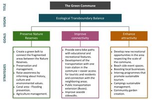
→ Green belt creation in three large areas of Bray-Dunes coasts to connect the fragmented ecological areas between the Nature Reserves.
→ “Nature Reserve of the Dune du Perroquet” and “National Nature Reserve of the Dune Marchland” preservation and management. Inscriptions throughout the nature reserves informing about history, culture and environmental values.
→ Provision and management of better connectivity with educational and recreational features along bicycle and pedestrian paths.
→ Transportation development: train station in the area and more bike paths.
→ Better attractions for young professionals and tourists. Recreational opportunities that will attract visitors from both De Panne and Dunkirk to visit Bray-Dunes, like community gardens.
→ There is a high pressure of urbanization among the area, this could be an opportunity, as well as a risk at the same time - building new housing could develop the area, but it could disturb the nature reserves too.
-
 SWOT method to indetify the potentials and risks

B.4 Theory reflection
Readings
→ Landscape character assessment (LCA) is defined as the process of identifying and describing variation in character of the landscape. In our process we used LCA documents to identify and explain the unique combination of elements and features that make our site distinctive by mapping and describing character types and areas. Landscape character assessment also shows how the landscape is perceived, experienced and valued by people.
→ Seascape character assessment (SCA) has emerged as a method for assessing, characterising, mapping and describing seascape character. Seascape is defined by Natural England in its position statement on All Landscapes Matter in 2010 as: “An area of sea, coastline and land, as perceived by people, whose character results from the actions and interactions of land with sea, by natural and/or human factors”.
→ Coastal character assessment (CCA) informs and guides coastal and marine planning, and individual development proposals, by informing landscape/seascape and visual impact assessments. As Bray Dunes is a coastal landscape, it was relevant to read about this assessment, it made us realise that the coast itself is complex and represents more than its physical characteristics.
→ Belgium and the Environmental Implementation Review (EIR) in 2017 the main challenges identified for Belgium for the implementation of EU environmental policy and law were to:
- improve air quality, in particular nitrogen dioxide levels, by reducing traffic congestion;
- continue to address water pollution coming from urban wastewater and agricultural sources;
- manage the Natura 2000 network towards favourable conservation status for all species and habitats.
→ France and the Environmental Implementation Review (EIR) in 2017 identified the following main challenges as regards the implementation of EU environmental policy and law in France:
- improving air quality by taking forward-looking, rapid and effective action to reach EU-based air pollution limit values;
- taking the necessary measures to improve water quality, particularly reducing nitrate pollution;
- effectively protecting biodiversity by enforcing the applicable law to ensure the protection of habitats and species.
→ The Marine Protection assessment from the Environmental Implementation Review for France 2019, gave us insights about which goals have been achieved and what would be the next priority actions:
- Provide information about measures to achieve Good Environmental Status (GES), establish more measures that have a direct impact on pressures.
- Ensure reporting of the different elements under the Marine Strategy Framework Directive.
→ Finally, the biodiversity protection describes also priority actions in order to improve the challenges in the area:
- Assess the Natura 2000 implementation and management.
- Support sustainable partnerships for biodiversity protection, sustainable development, climate change adaptation and mitigation measures.
- Protect habitats and species affected by or dependent on agricultural management.
Limitations
→ The most of the readings seem to be addressed to De Panne (on the Belgian side) and Dunkirk (on the French side), attracting a lot more interest, as they are considered areas with great strategic, economical and social importance. As a result, development plans are directed around Bray-Dunes, leaving a very significant natural ecological area, which contributes widely to the ecological coastal balance in the area, lacking attention and strategic management planning.
→ Urban infrastructure creation may impact negatively the ecology, but will promote the economy and connectivity critically.
B.5 References
BASE MAP SOURCE:
CONTENT - BLUE AND GREEN INFRASTRUCTURE:
- http://www.conservatoire-du-littoral.fr/siteLittoral/172/28-dune-du-perroquet-59_nord.htm
- http://www.conservatoire-du-littoral.fr/siteLittoral/213/28-dune-fossile-59_nord.htm
- http://www.water-ways.net/d/info/frankreich/nord_aa_canal_de_calais_de_Bergues_de_Furnes_de_bourbourg_de_la_colme.php
CONTENT - ACCESS AND TRANSPORT:
IMAGE SOURCES - CULTURAL AND NATURAL ATTRACTIONS:
- https://www.tracesofwar.com/sights/Bray-Dunes.htm?provinceid=139 /
- https://lenord.fr/jcms/pnw_5321/decouvrez-la-reserve-naturelle-dune-marchand /
- https://www.flickr.com/photos/73290459@N07/25434107707/
DEVELOPMENT PLANS:
READINGS:
- https://ec.europa.eu/environment/eir/pdf/report_fr_en.pdf
- https://ec.europa.eu/environment/eir/pdf/report_be_en.pdf
- https://www.gov.uk/guidance/landscape-and-seascape-character-assessments
- https://assets.publishing.service.gov.uk/government/uploads/system/uploads/attachment_data/file/691184/landscape-character-assessment.pdf
- https://assets.publishing.service.gov.uk/government/uploads/system/uploads/attachment_data/file/396177/seascape-character-assessment.pdf
- https://www.nature.scot/sites/default/files/2018-02/Guidance%20Note%20-%20Coastal%20Character%20Assessment.pdf
- https://www.nature.scot/professional-advice/landscape/coastal-character-assessment
Phase C – Strategy and Master Plan
C.1 Goal Setting
- Define strategic planning objectives based on the evaluation findings
- Link back to your original targets from section one and the Development Goals
- 150 words text contribution
Our main goals are:
- PRESERVE NATURE RESERVES
- IMPROVE CONNECTIVITY
- ENHANCE ATTRACTIVITY
-
 add caption here
 -
 Spatial vision translate: In a try to express visually our vision for Bray-Dunes, we developed a conceptual representation that includes the most important issues we wanted to address. The first goal includes the ecological fragmentation between the two Nature Reserves the area contains. The plan is to connect those fragmented areas through strategies that support the green belt creation and provide recreational and educational pedestrian and bike paths, enhancing at the same time the area to its trans-boundary extension. Ecological quality preservation for this diverse ecosystem and flood prevention through pumps and floodgates in the blue infrastructure are also suggested, while sustainable models for economic growth in the area are explained in the partnership and governance part extensively. Maybe a very important observation was the fact that the area does not have a train station. The railway though passes through Bray-Dunes and the old station building is used as a media library. Our suggestion is the reopening of the station as a mixed use building, which will attract tourists/young professionals and ease the transportation between De Panne and Dunkirk, two very financially developed cities. Finally new attractions are suggested on the economic growth tendency area, which is extended mostly on the beach.
 -
 Location Transects
 -
 add caption here
 -
 add caption here
 -
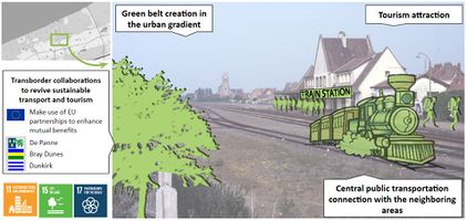 1. Intervention: Transportation improvement through reopening of the old train station.
 -
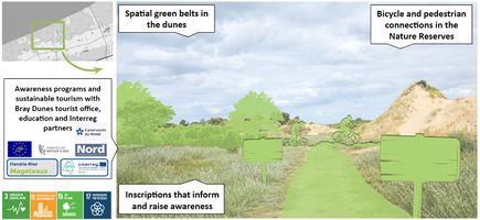 2. Intervention: Visualization of the Nature Reserve with the implementation of green belts, bike paths and informative inscriptions.
 -
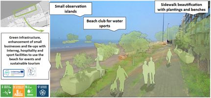 3. Intervention: Coast line area, suggestions of beautification and attractiveness increase.


C.3 From Theory of Change to Implementation
- For implementing your vision: Which partnerships are needed? Which governance model is required?
- Who needs to act and how? Draw and explain a change/process model/timeline
- Which resources are needed? On which assets can you build?
- add 150 words text and visuals
-
add caption here
-
add caption here
C.4 References
BASE MAP SOURCE:
IMAGES AND ICONS:
- https://i.pinimg.com/originals/cf/c5/d0/cfc5d0880997255e4ee06d908e6c2e74.jpg
- https://www.alltrails.com/de/france/hauts-de-france/bray-dunes
- https://www.alltrails.com/members/anne-molderez/photos
- https://www.cleanpng.com/free/kiss.html
- https://i0.wp.com/www.transparency-one.com/wp-content/uploads/2019/08/UN-SDGs-overview.png?resize=800%2C418&ssl=1
- https://thenounproject.com/
READINGS:
- https://www.interregeurope.eu/biogov/
- https://ec.europa.eu/regional_policy/sources/conferences/etc2018/plenary_session_2_moray_gilland.pdf
- http://www.mageteaux.eu/fr/projet
- https://demo-europe.eu/fr/page-daccueil/
- https://www.natuurenbos.be/projecten/west-vlaanderen/life-project-flandre/flandre/life-nature-project-flandre-english
D. Process Reflection
- Reflect in your intercultural and interdisciplinary team on the outcomes of your study
- Which limitations were you facing?
- What have you learnt from each other?
- What would you do differently next time?
- You can also use diagrams/visuals
- 250 words text