COLAND Case Study 2020 - Pärnu - Audru: Difference between revisions
Angela.horak (talk | contribs) No edit summary |
Angela.horak (talk | contribs) No edit summary |
||
| Line 303: | Line 303: | ||
== C.2 Spatial Strategy and Transect == | == C.2 Spatial Strategy and Transect == | ||
<gallery caption=" " widths="800px" heights="400px" perrow="1"> | |||
File:Strategytreeparnu.audru.png|''Strategy tree'' | |||
</gallery> | |||
Main idea for this area is that it will become a natural holiday destination with lots of fun outdoor activities. As there are many different types of landscapes in this area the new added hiking trail, on the coast side, will help people experience it all. There would also be a better and safer connection with transport and infrastructure. For example, two new pedestrian bridges will be added across the river for better access to the seaside and there will also be more signs that lead to the seaside and to the existing recreation areas all around the area. And the coastal area will have protection against floods to help and keep the nature there alive and well. | Main idea for this area is that it will become a natural holiday destination with lots of fun outdoor activities. As there are many different types of landscapes in this area the new added hiking trail, on the coast side, will help people experience it all. There would also be a better and safer connection with transport and infrastructure. For example, two new pedestrian bridges will be added across the river for better access to the seaside and there will also be more signs that lead to the seaside and to the existing recreation areas all around the area. And the coastal area will have protection against floods to help and keep the nature there alive and well. | ||
Revision as of 14:06, 19 April 2020
>>>back to working groups overview
| Area | Pärnu-Audru | |
| Place | Pärnu county | |
| Country | Estonia | |
| Topics | Site connectivity, recreation activities & objects, existing landscape preservation | |
| Author(s) | Marit Mõts, Angela Hõrak, Johanna Kapper, Ragne Nikkel, Nadina Patricija Zaremba | |

| ||
Rationale
Pärnu-Audru area has both natural areas and a big city on the coastline. The main challenge is to create a balance between valuable natural landscape and human activity. The site is vulnerable to natural forces like sea level rise due to climate change, rain caused flood, waves, wind and erosions.
Location and scope
You can edit this map with the map editor
A Landscape System Analysis
A.1 Landscape layers and their system context
Geomorphology, landscape units and coastal typology
Pärnu-Audru coast line is located in the south – west of Estonia in Pärnu bay and is a part of Pärnu city. Geomorphology of the site was formed by the melting of glacier. Afterwards coastal landscape was influenced by natural forces such as continuing lifting process of Earth’s crust and other. Coastline consists of fine sandy beach and dunes behind it and a protected coastal meadow. Pärnu - one of the biggest Estonian rivers discharges in the sea. The coast line and the sandy beach is changing due to a continuous sedimentation process.
The site is influenced by anthropogenic pressure as well as natural forces. Pärnu city is one of the biggest in Estonia and is a popular tourist attraction, it has a lot of residential, commercial, industrial areas and a port. The pollution created by the city and from river discharge promotes the eutrophication process. The site is vulnerable to sea level rise and affected by winds, waves, ice, and erosions.

Map of Valgerand showing the variations in the position of the coastline from the beginning of the 20th century (denoted by 1900) until 2008 (Estonian Base Map). The striped areas mark erosion (1) and accumulation areas (2). Café Doberan was originally constructed in the 1920s far from the waterline but is located directly at the shoreline today. The sandy section starts from the polder located at the left border of the panel
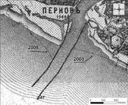
The Pärnu River mouth area in the beginning of the 20th century and the coastline of the Estonian Base Map (2008)

Pärnu port

Doberani beach house café, Valgeranna


Land use
Coastline is mostly used for recreational purposes due to scenic white beach behind which there are mostly coniferous and some mixed forests. Bay is used for water sports, fishing and ship traffic. Audru district consists mostly of different arable lands and forests. There is also a built up area and a golf course near the coast. Pärnu is a sparsely built up area. As every city it has residential, recreational and commercial areas, as well as industrial territories and since it is a seaside city and located by the river, it has a busy port. During warm seasons it gets a lot of tourist traffic and the population of Pärnu can even double. Densely built up areas and more natural territories are connected by road and railroad infrastructure. The city has and continuous to develop due to urbanization, growing population and industry as well as natural factors. There are protected nature areas near the site. To the border of Pärnu there is an airport and if it develops the land use is likely to change.

Land use map, 2012
The generalised sea-related socio-cultural values of Pärnu County”

Municipality of Pärnu


Green/blue infrastructure
GREEN:
- Valgeranna Conservation Area
- Valgeranna Adventure Park
- Valgeranna Golf
- Beach
- Audru polder conservation area
- Reed
- Old Pärnu beach
- Pärnu Beach Park
- Natural grassland
- Natural open area
- Forests
- Fields
- Private gardens
BLUE:
- Pärnu Bay
- River Pärnu
- River Audru
- Pärnu (cargo) port
- Pärnu Pier
- Artificial pond
- Ponds
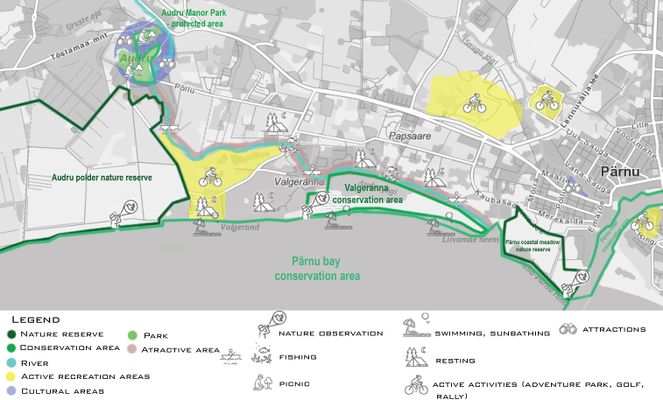
The availability of green and blue infrastructure is essential for the preservation of natural resources and values such as air quality, water purity and quality, public recreational facilities and climatic conditions. In Pärnu County, in the area between Pärnu and Audru, there are several elements of the green network and green infrastructure, different beaches, parks, people's gardens, rivers, ponds as well as two conservation areas.
Such a network of green and blue infrastructures will improve environmental conditions and thus the quality of life, support the economy and job opportunities, and increase biodiversity.
Green network protects nature from floods, member heat, and also helps to improve air, soil and water quality. Trees and woods in the area help to regulate the distribution of rainwater as they hold large amounts of rainwater. Forests and trees also retain carbon, which in turn improves air quality. Greening also improve people's quality of life, mental health and well-being.
There are also two conservation areas in the area between Pärnu-Audru, which are important sites for biodiversity and also for a better functioning green network. It allows nature to evolve more freely and provides connections between areas to provide the necessary pathways for species.
Different corridors between green and blue areas are useful for crossing different barriers for species. They also connect the green network and the blue network. In the area between Pärnu and Audru, such corridors include the Pärnu River and the Audru River.
The Blue Infrastructure Network includes various wetlands and biotopes that improve water quality and provide habitat for plants, improve soil conditions. Aquatic vegetation purifies water from pollutants and slows down water flow.

Audru polder

Valgeranna golf

Green/blue infrastructure


Actors and stakeholders
The area is located in Pärnu city, bordered with Audru municipality and Pärnu river. The western side of the area is more rural, before the merge of municipalities, there used to be small villages. The eastern part is divided into a living area and industrial area. After the merge, Pärnu city can mean a city as it were, the urban site or “new” Pärnu city with all municipalities and villages. The urban side of the area has a good bus connection, to Audru, there is one bus line (frequency 1 hour). As there are no high schools in the area anymore, a lot of students have to take a bus to the other side of Pärnu every morning. In the area, there is one big supermarket and two gas stations, seafood and rental industries. As there are still a lot of “empty” areas, developers see there a great opportunity to invest and build new houses. While a city grows it as money laying on the ground. But developers have to consider local governments’ authority and interests in this area. Pärnu is known for its beaches and turning summer a lot of tourists (mostly Finnish) visit it. They have bought themselves a flat and rent it out turning a winter. As Pärnu beach is really popular among tourists, local people prefer Valgeranna beach. It is located just south of Audru, the administrative centre of the municipality, on the coast of Pärnu Bay. The city of Pärnu is located 7 km east. Near to Valgeranna beach, there are a golf course and adventure park.

West-South Estonian population density

West-South Estionia population growth speed

Powermap1

Powermap1.2


The changes are mostly driven by municipality and developers. Pärnu comes to life in summer, then there are a lot of tourists both from foreign lands and other side of Estonia. Most actions are based on tourists needs and desires. Often have a high power outlanders, who aren’t affected by the changes. Major stakeholder of landscape changes are industries. In the city and Valgeranna area are lots of seasonal activities meant for tourist. As these places are important, job wise, for locals too, a costal landscape change would affect mostly locals and in the end municipality overall As there are not any high school left in the area, we can only conclude that educational institutions have a rather low power.
Sacred spaces and heritage
As it can be seen in the map most of the cultural monuments in this are are located in Audru. In Audru there is Audru Manor it is typical ensemble of manor buildings. Today 14 buildings are well preserved and undre heritage protection . In Second World War the mansion was destroyed and the office of the state farm was built in ist stead. The stone barn is the oldest building of the manor ensemble with a high saddle roof and walls that are more than a metre thick. There is still a natural stone distillery, maid’s house with a tall chimney, granary and the manager’s house where is now rural municipality’s museum and library. The manor is surrounded by park where flows Audru river with 4 bridges.
Audru Holy Cross Church built in 1680 into the same place where was old wooden church (1636) by Jürgen Grabing from Latvia. The present exterior was designed by major repairs in 1834 and 1872. The stone tower comes from 1715.
Near Valgeranna between pine forest there is old holiday complex. The recreation complex was established for members of the Nomenclature of the ESSR Council of Ministers and for their guests because they needed precious vacation opportunites and representative provisions as for informal meetings of the authorities. The main house included four suites, office rooms and large reception hall with utility rooms. Currently this house is restaurant. The recration complex as a whole is a vivid example of the nomenclature lifestyle, which diversifies th eundrestanding of the possibilities of Soviet construction practice and the bending rules. This Holiday Complex was not subject to standard building norms and guidelines that time.
The Old-Pärnu Cemetery dates back to the 15th century and is still in use today, with repeated rulings.
There is also a lot of heritage areas that has been destroyed and there is no visible signe about them but the maps provide information about their former existence. For example Audru fishflour factory, Audru battlefield, Audru parish school, Audru landlords' cemetery.

Pärnu-Audru cultural areas and places

Pärnu-Audru destroyed and forgotten places


Visual appearance and landscape narrative
This case study area is located on the coast of Pärnu Bay. Essential landscape characters of this area are sandy beaches, pine woods, old houses/apartments and beautiful views along the coast. Those views are quite magical and have also been painted by many hobby artists. One painting called Valgeranna is painted in 1962 by an Estonian artist called Enno Lehis. The painter used watercolors to show the atmosphere of this white sandy beach with beautiful pine forest. In addition to beautiful views, there are lots of other paintings about this study area. Maybe the most famous one of them all is called Pärnu jõgi painted in 1957 by Elmar Kits. It shows the view from the Vana Pärnu town to the Pärnu river. Furthermore, this case study and its surroundings have represented the filming location for a number of movies and documentaries. One of them, Yachts at Sea (in Estonia called: jahid merel), was directed by Mihhail Jegorov in 1955 and this movie tells the story of young yachtsmen from the coastal town who deals with daily work, training and competitions without knowing about the downside. Another movie that captures the coastal landscape of Valgeranna and its surroundings is movie called Behind the Door (in Estonia called: Ukse taga), made in 2004.

Pärnu jõgi, 1957, Elmar Kits

Valgeranna, 1962, Enno Lehis

Audru, 1930

Typical houses in Vana Pärnu area.


A.2 Summary of your landscape system analysis and your development targets
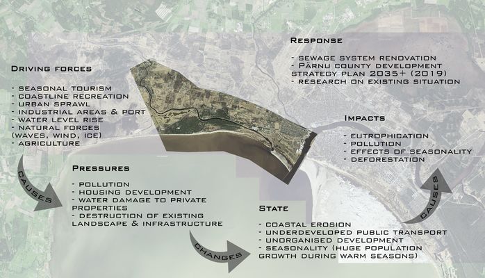
DPSI(R) model that summrizes the landscape system analysis

Sustainable Development Goals at risk
- Goal 3: Ensure healthy lives and promote well-being for all at all ages
By improving the quality of important environmental factors such as air, water and nature, it also creates conditions for better living conditions and the creation of a healthier society.
- Goal 6: Ensure Access to water and sanitation for all
The presence of water, clean and good water quality, good sanitation will ensure better nutrition and reduce disease and death.
- Goal 14: Conserve and sutainably use the oceans, seas and marine resources
The sea regulates many of the things that affect our lives, such as rainwater, drinking water, weather, climate, coastlines, much of the food and oxygen in the air. The oceans and seas have always been important channels of trade and transport. Careful and proper management of this important global resource is one of the key elements for a sustainable future.
- Goal 15: Sustainably manage forests, combat desertification, halt and reverse land degradation, halt biodiversity loss
Forests play an important role in providing food and shelter, while forests play a key role in regulating climate change and in creating biodiversity. By protecting forests, we can strengthen the management of natural resources and also increase land productivity.
Hypothesis:
The rising sea level is a problem for the city because of the bad pipe system. In that case, possible safety precautions must be considered for future planning as the area is floodable. Every year they build more and more new houses in Pärnu, which means that more and more younger people and families will be living there. City expansion. Bus connection is not available in the coastal area near Valgeranna. Bus connection improvements allow visitors to visit the seaside more often. The use of a personal car is reduced. More people means more housing and people -it will lead to deforestation

Graphical overview of the hypothesis. Balance is important.

Are there any existing initiatives taking action in this landscape? Do you have a critical perspective on that?
Pärnu County Development strategy plan 2035+ shows that as a coastal city, one of the stated goals is to reduce flood areas and upgrade the drainage pipe system. Research paper about population growth depicts that peripheral areas around Pärnu have been growing since 1989 about 25% or more while the city itself has been under a decrease of 10-25%. For population growth in peripheral areas, the city plans to renew the bus system and reduce the proportion of cars in the city. Also for young families, they are developing areas for cultural and youth activities. City wants to keep a steady line offering good quality services to tourists as it is the main income for most cafeterias, restaurants, and accommodations.
There are two protected areas on the west side of Pärnu bay. The city is not doing much about to avoid the destruction of infrastructure and erosion on the beach areas.
A.3 Theory reflection
International policy: Guiding Principles for City Climate Action Planning
Cities are beginning to realize the benefits of climate change. Facilitating climate change and the various mitigation measures that result from it will help cities meet their own development trends and priorities, address social challenges and environmental problems affecting cities. At the same time, cities are responding to other international action plans, such as the goals set out in the Sustainable Development Goals.
European policy: Maritime spatial planning
For renewable energy equipment, aquaculture and other uses – it has highlighted the need to manage our waters more coherently. Maritime spatial planning works across borders and sectors to ensure human activities at sea take place in an efficient, safe and sustainable way. That is why the European Parliament and the Council have adopted legislation to create a common framework for maritime spatial planning in Europe.
European policy: Communication on Green Infrastructure
Based on Communication on Green Infrastructure is it a strategically planned network of natural and semi-natural areas with other environmental features designed and managed to deliver ecosystem services such as water purification, air quality, space for recreation and climate mitigation and adaptation. The European Commission has developed a Green Infrastructure Strategy, the purpose of the document is that the protection, restoration, creation and enhancement of green infrastructure become an integral part of spatial planning. In our case, Pärnu–Audru area includes urban and rural sites, to improve citizens' life quality and health, implementation of this method, by maintaining forests and Pärnu bay area, is essential
National policy: National Spatial Plan Estonia 2030
The main development objectives are balanced and sustainable settlements, convenient mobile facilities, make the energy infrastructure more available and to improve green infrastructure connections as well as preserve existing landscape values. When it comes to marine areas, sustainable and efficient utilization of them is important for international competitiveness. Planning and balance are key for the preservation of waterbodies and nature and providing possibilities for recreation, tourism, commercial activities and national defence.
A.4 References
- https://www.researchgate.net/figure/Valgerand-in-the-south-west-of-Estonia-in-Paernu-Bay-Baltic-Sea-Rectangles-show-grid_fig1_266462686
- https://www.cruisemapper.com/ports/parnu-port-12059
- https://rannatee.ee/doberani-rannamaja-kohvik-valgerannas/#!
- http://mereala.hendrikson.ee/draft.html
- https://parnu.ee/en/
- https://corine.keskkonnaagentuur.ee/
- https://www.puhkaeestis.ee/et/audru-moisakompleks
- https://register.muinas.ee/public.php?menuID=monument&action=view&id=30410
- https://register.muinas.ee/public.php?menuID=monument&action=view&id=16610
- http://histrodamus.ee/?event=Show_event&event_id=3498&layer=218&lang=est#3498
- http://www.keskkonnaprojekt.ee/reference/keskkonnarajatised/parnu-sademevee-strateegia-aastani-2026/
- https://maakonnaplaneering.ee/documents/2845826/19109285/Edelaeestiastuseelujoud2018.pdf/f98f2eb9-8ecc-4eee-a454-f58fd913d7b4?fbclid=IwAR1THS_LxF7Y4hvz1L1i7zX0oe0oBZsFdba7nOLlxlh7HMzLgJEb9ZTLTmk
- https://ec.europa.eu/environment/nature/ecosystems/index_en.htm?fbclid=IwAR2rC2xs877ZyALmix3HmV9PhSHUQtImS5Eu6Sr_q8JtK4jTxTX4G1gItog
- https://op.europa.eu/en/publication-detail/-/publication/738d80bb-7d10-47bc-b131-ba8110e7c2d6
- https://www.americanrivers.org/threats-solutions/clean-water/green-infrastructure/what-is-green-infrastructure/
- http://www.adaptivecircularcities.com/designing-green-and-blue-infrastructure-to-support-healthy-urban-living/
- https://ec.europa.eu/environment/nature/ecosystems/benefits/index_en.htm
- http://www.audru.ee/tutvustus-ja-asukoht
- https://www.e-kunstisalong.ee/
- https://www.efis.ee/et/abi/moodulid/otsing&keywords=valgeranna&search_type=Films
Phase B: Landscape Evaluation and Assessment
B.1 Assessment Strategy
Based on our previous landscape system analysis we can see that the rising sea level is a problem for the city because of the bad pipe system and safety precautions must be considered for future planning as the area is floodable. Every year they build more and more new houses in Pärnu, which means that city is expanding. Also the bus connection is bad and needs to be improvements to allow visitors to visit the seaside more often. The area is very popular in summer time among the locals but we would like to make it accessible for tourists also. Therefore, our goal is to keep this beautiful nature and create an opportunity for locals and tourists to enjoy it even more.
Based on the previous information and analysis, it is important to us to map the following elements:
- Connectivity
- Recreation
- Landscape
B.2 Mapping

Accessibility map – this map shows existing road infrastructure and accessibility of the site. There are roads of different importance and accordingly the intensity of use and quality varies. There are quite a lot of bus stops, but most of them are concentrated in the city centre where the bus frequency is also better. The bus to Valgeranna beach runs rarely but to Audru quite frequently. Parking wise there are not a lot of opportunities and most of them are low quality. There is only one bridge leading to Valgeranna beach, some roads are bad quality and there is not enough information about possible activities. However, proximity of different landscapes and therefore recreation possibilities is positive as well as existing sidewalks and bicycle lanes also outside the city centre.
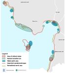
Recreation map- This map shows existing recreation areas. Our project area is covered with different activities and places what to do. Costal area is good place for swimming and sunbathing. Yellow areas are presenting more active leisure activities like adventure park, golf center, car ring. The river (color light blue) is also an important recreation point. This river is well know by fishermen and it is popular place for them. In Audru there is more cultural areas (which is colored dark blue) because of this Audru manor and its associated buildings and parks. This map illustrations show where and what kind of activities take place and what are the main recreational activities in our project area and according to that and other maps we can found out what places and activities need improvement and planning.

Experience map - This map shows the experience and cognition of different types of landscapes. There are many different types of land use in this project area - different forests, several fields and grasslands, protected areas, long shoreline and many different building and industrial areas. The map shows people's experiences through different roads, forest and agricultural areas, shorelines, riverside and recreational areas. Darker tones indicate all the more crowded and noisy areas. Lighter tones indicate calmer and quieter areas. Accordingly, coastal areas, attractions and active recreation areas are slightly more crowded as they attract more tourists as well as locals.


B.3 Problem definition and priority setting
According to previous maps, we can see that the main problem concerns erosion and flood in this area. Every year the Pärnu coastal area moves a bit inland. Strong winds and coastal erosion destroys “much loved” sandy beaches and coastal near 200-year-old forests. Experts speculate that if it continues that way, the Valgeranna adventure park is going to be the next thing that is in danger. For that, we should move this, one of a kind coastal adventure park, bit more inland.
In the area, there are a lot of small settlements, which are now part of the Pärnu city municipality. In the area, new houses are built by private developers and without any system or connection to the surroundings. Moreover, a lot of older buildings are in bad condition, some are abandoned,increasing the bad reputation of the area.
There’s only one car road to access the beach area, during the summertime there is also a lack of parking. As there’s a brand new light traffic route from the highway to Valgeranna beach, it gives the good potential for a public bike system. Also for use in Pärnu and Audru. Nevertheless, such an area can be seen as potential by showing the coastal landscape and different characters. There is good potential to do a hiking trail through forest, bog and green space, also a gazebo to offer nice views on the sea over different land characters.
As Pärnu and its tributaries are one of the richest of fish species, there are good potentials to make official fishing spots for locals. Pärnu County is a very historical place. Loss of heritage is a big risk all over Estonia and to introduce it to both tourists and locals, there is a need to improve road conditions and install signs.

risks & potential map

B.4 Theory reflection
For our assessment we chose to use the Strengths-Weaknesses-Opportunities-Threats (SWOT) analysis. It helped us to see different strengths, weaknesses, opportunities and threats of each element we choose to map out.
We also mapped down different roads for pedestrians and for transportation, it helped us to see how accessible is the area overall and look for the potentials of the area and also see what was missing.
And one of the most important was the Landscape Character Assessment (LCA) which helped us get an overview of the Pärnu-Audru area in a wider context and see what kind the different types of landscapes we can experience there.
B.5 References
- https://xgis.maaamet.ee/xgis2/page/app/maainfo
- https://www.google.ee/maps/@58.387532,24.4403068,12z?hl=et
- https://www.puhkaeestis.ee/et/eesti-kaart?utm_medium=map_est
- https://www.floodmap.net/?gi=589580
- http://www.peatus.ee/#route_search/eng
Phase C – Strategy and Master Plan
C.1 Goal Setting
The aim of this project is to sustain and enhance the existing natural, social and cultural values of the coastal and river landscape and provide new usage opportunities & better connected infrastructure for locals as well as nature & cultural heritage tourism. We also want to maintain a balance between nature and people activity and provide different possibilities of interaction between locals and tourists. Vision: after reaching the goal there will be natural diverse coastal and river landscape with minimized erosion risks, easily accessible and used by different groups of people for nature recreation and different leisure activities, that is regularly maintained, monitored and keeps developing in the interests of all stakeholder groups.
Our priorities are:
- Existing landscape preservation
- Site connectivity
- Recreation activities & objects
And accordingly the objectives are:
- Protecting the existing landscapes and biodiversity from human and nature destructive influences
- Providing information, infrastructure and possibility to easily access the area and the recreational as well as cultural heritage sites
- Developing existing recreation activities and creating new ones based on possibilities provided by landscape and cultural heritage
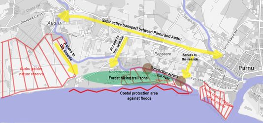
C.2 Spatial Strategy and Transect

Strategy tree

Main idea for this area is that it will become a natural holiday destination with lots of fun outdoor activities. As there are many different types of landscapes in this area the new added hiking trail, on the coast side, will help people experience it all. There would also be a better and safer connection with transport and infrastructure. For example, two new pedestrian bridges will be added across the river for better access to the seaside and there will also be more signs that lead to the seaside and to the existing recreation areas all around the area. And the coastal area will have protection against floods to help and keep the nature there alive and well.
Concept plan


New Accessibilities

Masterplan - The main idea is to create a hiking trail that is marked in green on the map. There are various bike paths leading to it, with 5 bike stations. There are currently 3 observation towers in the area, but with the new solution we will create 1 more birdwatching tower next to the hiking trail. Also, as the new hiking trail crosses the river, we will create 2 more pedestrian bridges. With the new solution, we will also improve the existing parking lots and create 3 new parking possibilities. With the new idea, we will also add 3 decent fishing spots for fishermen.'

Section of the new bridge

Section with road sign


View 1

View 2

View 3


C.3 From Theory of Change to Implementation
In the governance model, we have indicated who manages the site, who regulates, what the legislation is, who finances it and who deals with analysis and construction. The project area is managed by the local government, Pärnu city government, which regulates waste management, road maintenance, and so on. At the same time, it also helps to create an electric bicycle circuit. Local businesses manage such as Valgeranna Golf and Adventure Park, local cafes and restaurants, (as well as Bolt scooter rental.) Also RMK, which is the Estonian State Forest Management Center and is a forest keeper, protector and manager. The regulators are the Republic of Estonia and Natura 2000. The Republic of Estonia manages the Beach and Shore protection, construction laws and road management. Also, as the Audru polder is a nature reserve in our area, one of the regulators is Natura 2000, which aims to protect the habitats and rare or endangered animals, birds and plants. The financiers would be the local government, which provides financial support as well as start-up support for new companies. Secondly, there would be the government of the Republic of Estonia, which financially supports local government, and the European Union, which promotes the local economy. Analysis and construction are carried out by various specialists such as Pärnu city architects, urban design specialists and construction supervisors.

Covernance model

Process


C.4 References
- https://xgis.maaamet.ee/xgis2/page/app/maainfo
- https://www.google.ee/maps/@58.387532,24.4403068,12z?hl=et
D. Process Reflection
Limitation for our group was language and knowing where to find information. The design part was also difficult by the fact that due to the situation it was not possible to visit the place.
With this group work we learned that each of us have different approaches and visual design ideas