Nile Delta: Difference between revisions
Jump to navigation
Jump to search
| Line 81: | Line 81: | ||
<gallery caption=" " widths="200px" heights="150px" perrow="5"> | <gallery caption=" " widths="200px" heights="150px" perrow="5"> | ||
File: | File:Stanley bridge.jpg | ||
File: | |''Stanley bridge in alexandria (west delta)'' | ||
File:Suez canal adminstration building.jpeg|''Suez canal adminstration building'' | |||
File:your case_sacredspace3.jpg|''add a caption'' | File:your case_sacredspace3.jpg|''add a caption'' | ||
</gallery> | </gallery> | ||
Revision as of 20:02, 18 April 2018
>>>back to working groups overview
| Area | Nile delta | |
| Place | North of Egypt | |
| Country | Egypt | |
| Topics | Tourism and nature protection | |
| Author(s) | Ahmed kamal | |

| ||
Rationale
- Nile delta is the breadbasket of Egypt, 2\3 of the agriculture products comes from this area supporting 40 million of people and considering one of the best regions for agriculture in Egypt due to its location on the Midetterian sea besides two branches of Nile river in the lower part in Egypt which consider the source of water in these region. the coastline of Nile delta from Port said city to Alexandria city consider one of the most vulnerable coastlines in the world facing the problem of coastal erosion and rising sea level due to its lower elevation.
Location and scope
You can edit this map with the map editor
A Landscape System Analysis
A.1 Landscape layers and their system context
Geomorphology, landscape units and coastal typology
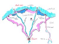
- The Nile delta is formed by the two branches of Nile river in the lower part in Egypt. It spread out to V shape fan due to the Nile flood in the past before the high dam constructed in the upper part of the Nile. The construction of the high dam limited the Nile river to two branches (Rashid branch on the west and Dumyat branch on the east)
-
 add a caption
 -
add a caption

Land use
- The Nile delta coastline begins from the east in Port said city which consider a big harbour located at the sea and very dense settlement to Alexandria city in the west which consider residential and recreational area all the year. The area between them very diverse between the agriculture fields due to the Nile river and, fishing farms, three big sea lagoons (Idku, lake Burulls and lake Manzella ) produce 60% of the fish catch beside small urban cities.The most activities in this area are fishing, agriculture and tourism. too many agriculture areas near the coast not suitable for cultivating and the function changed to fishing farm because the soil becomes salinity.
-
 Landuse map (by the author)
 -
 Typology of coastline (by the author)
 -
 Alexandria city (west side of delta)
 -
 Port said city (East side of delta)
 -
 Ras el bar city (Resedential and recreational area)
 -
 Nile river at the right and the sea in the left


Green/blue infrastructure
- What are the major potential elements of a green/blue infrastructure network? Are these likely to change/disappear? Why is that?
- You find my background material on green infrastructure in our reading list
- add 1-2 graphical representations to the image gallery, you can add more if you like
-
 Green infrastructure (by the author)
 -
add a caption

Actors and stakeholders
- Who is driving changes in this landscape? Who is affected by those changes?
- Draw a stakeholder and/or power map: Who is affected highly but with low power? Who has high power but is not affected?
-
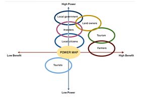 Power map edited by the author

Sacred spaces and heritage
- Which places/elements hold cultural value and to whom?
- You may add a map and some images, please also explain in your caption why these elements are valuable
-

-
 Suez canal adminstration building
 -
add a caption


Visual appearance and landscape narrative
- Which elements are essential for the landscape character?
- Has the landscape been painted or otherwise depicted, when and whom? Which elements are essential?
- Which narratives exist? Who has written about this landscape or depicted it in some way?
- You can add text and images
-
add a caption
-
add a caption
-
add a caption
A.2 Summary of you landscape system analysis and your development Targets
- You can summarize your findings with an DPSI(R) Model or a Spider Diagram
- Link back to the Sustainable Development Goals: Which goals are at risk?
- What is your hypothesis for this landscape?
- Visualise your hypothesis with one graphic/pict
- Are there any existing initiatives taking action in this landscape? Do you have a critical perspective on that?
- Add text and visuals
-
explain your analysis briefly in the caption
-
explain your hypthesis briefly in the caption
A.3 Theory reflection
- Reflect on at least three international policy documents in relation to their local landscape case
- choose one international, one European and one national document
- You can choose references from our reading list
- Scope: 250 words
A.4 References
- give a full list of the references you have used for this section
Phase B: Landscape Evaluation and Assessment
B.1 Assessment Strategy
- Based on the hypothesis derived from your previous landscape systems analysis you are now asked to define the goals for assessing the landscape. Your assessment is the basis for evaluating the landscape status.
- Which elements and phenomena need to be mapped, why and how?
- This a text contribution, max 250 words
B.2 Mapping
- As defined by your assessment strategy you conduct the mapping and present your findings here
- As a minimum, at least three different themes need to be mapped, you may choose more if needed
-
briefly explain the findings of your mapping
-
briefly explain the findings of your mapping
-
briefly explain the findings of your mapping
B.3 Problem definition and priority setting
- Give a summary of the major findings of your mapping process, what are the problems/potentials identified?
- Draw a problems/potentials map
- Set priorities for the most relevant issues
-
add caption here
B.4 Theory reflection
- Please reflect the assessment and evaluation methods used based on at least three readings
- Did you encounter limitations'
- 200 words test contribution
B.5 References
- give a full list of the references you have used for this section
Phase C – Strategy and Master Plan
C.1 Goal Setting
- Define strategic planning objectives based on the evaluation findings
- Link back to your original targets from section one and the Development Goals
- 150 words text contribution
C.2 Spatial Strategy and Transect
- translate your strategic goals into a vision
- develop a spatial translation of your vision
- exemplify your vision in the form of a transect with concrete interventions
- add map(s) and visualizations
-
add caption here
-
add caption here
-
add caption here
-
add caption here
C.3 From Theory of Change to Implementation
- For implementing your vision: Which partnerships are needed? Which governance model is required?
- Who needs to act and how? Draw and explain a change/process model/timeline
- Which resources are needed? On which assets can you build?
- add 150 words text and visuals
-
add caption here
-
add caption here
C.4 References
- give a full list of the references you have used for this section
D. Process Reflection
- Reflect in your intercultural and interdisciplinary team on the outcomes of your study
- Which limitations were you facing?
- What have you learnt from each other?
- What would you do differently next time?
- You can also use diagrams/visuals
- 250 words text