Loksa and Lahemaa: Difference between revisions
| Line 91: | Line 91: | ||
Major elements of a green infrastructure network in Lahemaa: | Major elements of a green infrastructure network in Lahemaa: | ||
''Juminda peninsula'' | *''Juminda peninsula'' | ||
Pärispea peninsula | *''Pärispea peninsula'' | ||
Käsmu peninsula | *''Käsmu peninsula'' | ||
Hara island | *''Hara island'' | ||
Mohni island | *''Mohni island'' | ||
Glacial drift | *''Glacial drift'' | ||
Forests | *''Forests'' | ||
Stoney beaches | *''Stoney beaches'' | ||
Meadows and grasslands | *''Meadows and grasslands'' | ||
'''Mires and bogs:''' | '''Mires and bogs:''' | ||
Revision as of 09:27, 19 April 2018
>>>back to working groups overview
| Area | Loksa and Lahemaa | |
| Place | Loksa | |
| Country | Estonia | |
| Topics | Erratic boulders, Nature protection and develop tourism (Ecotourism) | |
| Author(s) | Shima, Silvia, Amene, Mariliis | |

| ||
Rationale
Why do you think this case is relevant? What is your hypothesis considering the landscape challenges? Format: 3-4 sentences
Lahemaa National Park is situated on the Gulf of Finland. The national park was established to preserve landscapes typical of Northern Estonia where wooded areas are predominantly unaffected by human activity, semi-natural communities are well-maintained and great effort is made to preserve and restore cultural values. The sea plays a great role in defining the natural environment and cultural history of the area. It dictates the weather, shapes coastal communities and functions as a food source. Landforms brought about by the earlier stages of the Baltic Sea can be seen quite far inland.
Location and scope
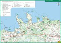
You can edit this map with the map editor
A Landscape System Analysis
A.1 Landscape layers and their system context
Geomorphology, landscape units and coastal typology
- Description of evolution, status quo and driving forces, is the coastal typology changing? Why is that? (approx 200 signs) - add 1-2 graphical representations to the image gallery, you can add more if you like
A number of landscape types characteristic of Northern Estonia are represented here, such as the coastal plain and islands of the Gulf of Finland, the plateaus of Harju and Viru and the region of Kõrvemaa with its hills, mires and lakes. The coastline is dotted with peninsulas, bays and small islands. It is the abundance of bays in the area that inspired J. G. Granö, the founder of modern geography in Estonia, to name the region Lahemaa (the Land of Bays) in the early 20th century. In the national park, erratic boulders, including gigantic boulders and boulder fields, are found in great abundance. The most impressive among them is a 400-hectare boulder field in the Käsmu forest, while another similar site, a group of erratic boulders called the Kloostrikivid (Convent Stones) in the Palmse woods, is definitely worth a visit.Communities typical of Lahemaa are sea, forests, mires, semi-natural communities, rivers, lakes and outcrops.Sea makes up one-third of the national park’s surface area. A variety of coastal habitats cover a total of some 8,850 ha. The majority (covering around 6,380 ha) are shallow waters and underwater sand banks. In addition, there are sandy and muddy foreshores which become exposed in windy weather, shallow coastal lagoons which are still occasionally connected to the sea, shallow bays, rocky reefs, coastal berms piled up on the waterfront, shingle and sandy beaches and dunes. There is a variety of beaches in Lahemaa. Sand ryegrass with bluish-grey, sharpedged leaves, sea sandwort and sea pea, a protected species, all grow on sandy beaches. Further inland where the sand is more stable, it becomes covered in lichen, and in some places crowberry takes root, giving the dunes a grey-and-russet appearance.
-
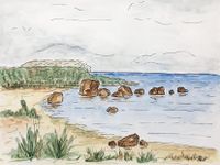
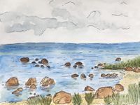 Rocky beach
 -
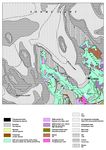 geomorphology map
 -
 Erratic boulders


Land use
In this area there are eight settlements: Loksa, Hara, Kasispea, Vihasoo, Tammispea, Eru, Kotka and Vatku. All these settlements are under Lahemaa national park protection area except Loksa city. There is a good infrastructure between all these villages also to Estonian capital city Tallinn. There is boat connection in Loksa harbor but unfortunately it is not regulary used.
Lahemaa national park is good tourism attractions. In there they offer guided tours and programs in and around Lahemaa National Park. There are nature study trails, beautiful landscapes, cultural heritage, four stunning manor complexes and a diverse coastline.
In Loksa there is passive resource of clay 34,19 ha and passive reserves of sand 34,1 ha. These sand resources is also in Kotka. Reserves of peat resources are in Hara active reserves and the area is 598 ha. There is not much agriculture in this area because it is hard to do this because of restrictions. In Loksa there is unsuitable soil for agriculture, it is sandy and significant amount of forest.
According to Corine land cover map it describes this case study area as:
- discontinuous urban fabric,
- industrial or commercial units,
- coniferous forest,
- mixed forest,
- broad-leeaved forest,
- beaches, dunes, sands,
- indland marshes,
- pastures,
- sea and ocean,
- natural grassland,
- waterbodies,
- peat bogs,
- transitional woodland-shrub,
- land principally occupied by agriculture, with significant areas of natural vegetation.
In the future, probably the area is going to be quite same because most of it is under nature protection where are many restrictions for building, agriculture etc. These restrictions are limiting the area development but they can advance tourism, which brings people to this area and raises the potential for economic growth. In Loksa maybe they are going to use more of this harbor because of its beneficial placement of port harbor and develop sea routes. Also, Loksa can be popular among tourists for its housing and food benefits.
-
add a caption
-
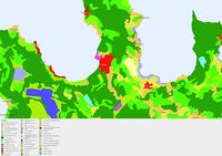 land use map
 -
add a caption

Green/blue infrastructure
- What are the major potential elements of a green/blue infrastructure network? Are these likely to change/disappear? Why is that?
- You find my background material on green infrastructure in our reading list
- add 1-2 graphical representations to the image gallery, you can add more if you like
Major elements of a green infrastructure network in Lahemaa:
- Juminda peninsula
- Pärispea peninsula
- Käsmu peninsula
- Hara island
- Mohni island
- Glacial drift
- Forests
- Stoney beaches
- Meadows and grasslands
Mires and bogs: Viru bog Lohja mire Vanasilla Bog Harasoo Laukasoo Pudisoo Karupõllu mire
Turbuneeme beach
Hiking trails:
Beaver trail (1 km)
Oandu natural forest trail (4.7 km)
Oandu plant trail (1 km)
Oandu heritage culture trail (3.4 km)
Altja nature and cultural history trail (3 km)
Ojaäärse forest trail (3.5 km)
Trails on Käsmu Peninsula
Viru bog study trail (3.5 km)
Majakivi-Pikanõmme study trail (7 km)
Tsitre tree trail (0.5 km)
Mohni study and hiking trai
Coastal nature study trails on Pärispea Peninsula (Hara Bay study trail (3.3 km), Pähkneeme study trail (1.6 km), Purekkari study trail (1 km))
Võsu cultural history trail (3 km)
40-kilometre section of the RMK Oandu-Aegviidu-Ikla hiking route passing through Lahemaa National Park
The Oandu-Võsu hiking trail (9.5 km)
The Võsu-Nõmmeveski hiking trail (18 km)
The Nõmmeveski-Liiapeksi hiking trail (16 km)
Kolgaküla health trails (longest option: 10 km)
Major elements of a blue infrastructure network in Lahemaa:
Hara bay
Eru bay
Rivers and streams: Kahala river Valgejõgi (river) Lohja river Oja river Kotka river Loobu river Kolga river Loo river Käsmu river Võsu river Pudisoo river Altja stream Mustoja stream
Lakes and pounds: Loksa pounds Maalaht Ulglaht Lohja lake
-
 North-Estonian recreation area: Lahemaa National Park Hiking trails Map of State Forest Management Centre (RMK)
 -
add a caption

Actors and stakeholders
- Who is driving changes in this landscape? Who is affected by those changes?
- Draw a stakeholder and/or power map: Who is affected highly but with low power? Who has high power but is not affected?
State Forest Management Centre (RMK) has been involved in visitor management in the Lahemaa National Park since February 2009. Protected area manager is enviromental board of estonia and the last one drives the changes in this landscape. They give permission to build something on this nature protection area. In Loksa the municipality gives permission to drive changes in Loksa.
-
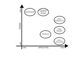 power map

Sacred spaces and heritage
- Which places/elements hold cultural value and to whom?
- You may add a map and some images, please also explain in your caption why these elements are valuable
In Lahemaa, traces of human activity date back to the Middle Stone Age. The area has been permanently settled for 4000 years and landscapes here have been preserved in their original form for centuries.The national park encompasses the territories of three parishes (Kuusalu, Kadrina and Haljala) which stand out for their rich folk culture heritage. As far as is known, five dialects were spoken by the locals here, with modern standard Estonian evolving on the basis of the middle-North Estonian dialect, while a great number of folk songs and popular sayings have been recorded in the North-Eastern dialect. The park’s village landscapes and architecture are multi-layered – here, traditions spanning thousands of years as well as innovations created by creative minds exist side by side. Typically, the whole village would get involved in all activities, whether major works or celebrations. People sang when on the village swing, during festivities, at weddings and funerals, to their children and when working.People sang when on the village swing, during festivities, at weddings and funerals, to their children and when working. Creation myths in runic verse originating in these coastal areas have been associated with those known from the Finnish national epic Kalevala.
Many Estonian folk dances have been recorded in this region. Locals used to dance to the music of the bagpipes, violin and diatonic accordion. Farming, raising livestock and fishing have been traditional sources of livelihood in these areas. All of the necessary objects were made by specialised craftsmen. The people here were able to forge iron objects and build ships. Worship and heritage sites known from folk beliefs were inspired by erratic boulders, the tips of capes, stones, trees and springs. So-called wishing stumps and fish chapels were distinct features characteristic of the coastal regions in the area.
-
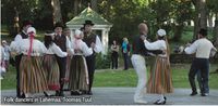 Folk dancers in Lahemaa, Toomas Tuul
 -
 add a caption
 -
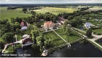 Palmse Manor, Jaak Nilson


Visual appearance and landscape narrative
- Which elements are essential for the landscape character?
- Has the landscape been painted or otherwise depicted, when and whom? Which elements are essential?
- Which narratives exist? Who has written about this landscape or depicted it in some way?
- You can add text and images
Lahemaa is perfect for a nature watching becauce its natural and cultural diversity. Here you will find stony and sandy seashores, picturesque bogs, pine and cliff forests, rivers that cut into the limestone cliff as well as erratic rocks left over from the last Ice Age. Also the coastal area is rich in peninsulas and bays. The bays have versatile bottom relief, are generally deep and there are plenty of submerged rocks and islands.
Lahemaa national park is popular among hobby photographers and painters beacause of its natural diversity. Also enviromental board of Estonia arrange different competitions about it. Last one was about “My home Lahemaa”, task was to draw or take pictures about Lahemaa. Best pictures was awarded. There were one architectural competition about 21. Century home in Lahemaa. They had to design modern Estonian country house taking into account the spatial and cultural characteristics of Lahemaa and Estonian village architecture. There are many literature about Lahemaa. Many story telling and history books. Some poems about it. Like Andrus Norak wrote about Lahemaa and it was published in children magazin Täheke.
-
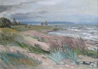 "Lahemaa beach" oil, hardboard 1998 (49x70 cm)/Kalju Nagel - Kunst /erakogu ( private collection)
 -
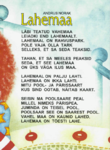 poem about lahemaa,Andrus Norak
 -
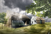 architectural competiton in Lahemaa


A.2 Summary of you landscape system analysis and your development Targets
- You can summarize your findings with an DPSI(R) Model or a Spider Diagram
- Link back to the Sustainable Development Goals: Which goals are at risk?
- What is your hypothesis for this landscape?
- Visualise your hypothesis with one graphic/pict
- Are there any existing initiatives taking action in this landscape? Do you have a critical perspective on that?
- Add text and visuals
-
explain your analysis briefly in the caption
-
explain your hypthesis briefly in the caption
A.3 Theory reflection
- Reflect on at least three international policy documents in relation to their local landscape case
- choose one international, one European and one national document
- You can choose references from our reading list
- Scope: 250 words
A.4 References
- http://www.loksalinn.ee/tutvustus-ja-asukoht
- https://land.copernicus.eu/pan-european/corine-land-cover/clc-2012/view
- Suuroja, K., All, T., Kõiv, M., Mardim, T., Morgen, E., Ploom, K., Vahtra, T., 2002. Eesti geoloogiline baaskaart (mõõtkavas 1:50 000). 7322 Loksa. Seletuskiri, 85.
- http://loodusegakoos.ee/kuhuminna/rahvuspargid/lahemaa-rahvuspark
- https://www.puhkaeestis.ee/et/ponevad-paigad/pohja-eesti/lahemaa-rahvuspark
- Lahemaa National Park Harju and Lääne-Viru County, www.keskkonnaamet.ee
- http://www.loksa.ee
- https://www.visitestonia.com/en/nature-trip-to-lahemaa-national-park-1
- http://maaleht.delfi.ee/news/maaleht/uudised/vaata-sellised-majad-voivad-kerkida-lahemaale?id=65174410
- https://kaitsealad.ee/eng/nature-6
- http://www.eestiloodus.ee/artikkel3889_3850.html
Phase B: Landscape Evaluation and Assessment
B.1 Assessment Strategy
- Based on the hypothesis derived from your previous landscape systems analysis you are now asked to define the goals for assessing the landscape. Your assessment is the basis for evaluating the landscape status.
- Which elements and phenomena need to be mapped, why and how?
- This a text contribution, max 250 words
B.2 Mapping
- As defined by your assessment strategy you conduct the mapping and present your findings here
- As a minimum, at least three different themes need to be mapped, you may choose more if needed
-
briefly explain the findings of your mapping
-
briefly explain the findings of your mapping
-
briefly explain the findings of your mapping
B.3 Problem definition and priority setting
- Give a summary of the major findings of your mapping process, what are the problems/potentials identified?
- Draw a problems/potentials map
- Set priorities for the most relevant issues
-
add caption here
B.4 Theory reflection
- Please reflect the assessment and evaluation methods used based on at least three readings
- Did you encounter limitations'
- 200 words test contribution
B.5 References
- give a full list of the references you have used for this section
Phase C – Strategy and Master Plan
C.1 Goal Setting
- Define strategic planning objectives based on the evaluation findings
- Link back to your original targets from section one and the Development Goals
- 150 words text contribution
C.2 Spatial Strategy and Transect
- translate your strategic goals into a vision
- develop a spatial translation of your vision
- exemplify your vision in the form of a transect with concrete interventions
- add map(s) and visualizations
-
add caption here
-
add caption here
-
add caption here
-
add caption here
C.3 From Theory of Change to Implementation
- For implementing your vision: Which partnerships are needed? Which governance model is required?
- Who needs to act and how? Draw and explain a change/process model/timeline
- Which resources are needed? On which assets can you build?
- add 150 words text and visuals
-
add caption here
-
add caption here
C.4 References
- give a full list of the references you have used for this section
D. Process Reflection
- Reflect in your intercultural and interdisciplinary team on the outcomes of your study
- Which limitations were you facing?
- What have you learnt from each other?
- What would you do differently next time?
- You can also use diagrams/visuals
- 250 words text