Island of Sylt: Difference between revisions
| Line 170: | Line 170: | ||
== B.5 References == | == B.5 References == | ||
* ''http://www.dezandmotor.nl/en/research/results-after-five-years/'' | * ''http://www.dezandmotor.nl/en/research/results-after-five-years/'' | ||
* ''https://www.schleswig-holstein.de/DE/Fachinhalte/K/kuestenschutz_fachplaene/Sylt/1_2_einleitung_entwicklung.html'' | |||
* ''https://de.wikipedia.org/wiki/Norwegischer_Strom'' | |||
=Phase C – Strategy and Master Plan = | =Phase C – Strategy and Master Plan = | ||
Revision as of 11:00, 15 May 2018
>>>back to working groups overview
| Area | Island of Sylt | |
| Place | Westerland | |
| Country | Germany | |
| Topics | tourism, nature protection | |
| Author(s) | Florian Matthies | |

| ||
Rationale
- Why do you think this case is relevant? What is your hypothesis considering the landscape challenges?
- The island of Sylt in Germany is a very important tourist destination and plays an essential role for the region's economy. However, Sylt is facing tremendous challenges considering the massive loss of land due to erosion and storm tides which endangerous its future for tourism. But also the tourism has strong negative impacts, like gentrification, which drives out the local population.
Location and scope
You can edit this map with the map editor
A Landscape System Analysis
A.1 Landscape layers and their system context
Geomorphology, landscape units and coastal typology
- Description of evolution, status quo and driving forces, is the coastal typology changing? Why is that? (approx 200 signs)
The coastal landscape of Sylt is characterized by long sandy beached and sand dunes. On the western side there is a 30 m high cliff coast, the 'red cliff'. To the east, the island is connected to tidal flats. Sylt was created by a moraine of the last ice age. The rock eroded in the course of a sea level rise 8000 years ago. Thereby the western edge was pushed more and more to the east, while the island extended to the north and south. Until 1362 Sylt could be reached overland during low tide. Then Sylt became a real island after a massive storm tide washed away a lot of sediment between Sylt and the mainland. During the last centuries the characteristic shape of the island is constantly subjected to changes, especially the northern and southern parts. Because of the tidal activity and strong sea currents these parts were sometimes larger or smaller, sometimes connected or disconnected to the rest of the island. A big problem is the permanent loss of land, especially caused by storm tides. In average the sea takes away one meter coast line per year. Due to the climate change and thereby increased storm tides, the threat to the island grows larger and larger.
-
 sand dune and beach
 -
 30m high 'red cliff'


Land use
- settlements, infrastructure, agriculture, resource extraction, natural areas, energy production...
- description of evolution, status quo and driving forces, is the land use likely to change? Why is that? (approx 200 signs)
The population of Sylt is around 17.700. Apart from the biggest town Westerland there are several smaller villages distributed on the island. Since 1927 Sylt is connected by a railroad on an artificial dam to the mainland. Regional and intercity trains are arriving and departing in Westerland. A road connection to the main land is not existing. Besides the train, there are several ferry connections to the mainland and the neighboring islands. The road net work on the island is well developed. Public transport on the island is available by several bus lines. The local train connection on the island was decommissioned in 1970. Today the former track serves as cycle connection from north to south and adds to the 250 km excellent cycle network of the island. Since the 70s agriculture plays a very subordinated role in the island's economy. Nowadays the economy is almost entirely related to tourism. Tourism started very early on Sylt. In 1855 Westerland was declared as sea resort and became very popular of its cures. In the 60s tourism developed rapidly and big hotels and apartment houses emerged. Sylt has very rich natural landscapes. Many places are protected. There are 10 nature protection areas and several landscape protection areas, FFH and Natura 2000 areas. A big impact on the land hast the real estate market. The huge demand of housing and lack of space cause the highest real estate prices in whole Germany. Gentrification is extremely high. The local population is no longer able to cope with exploding living expenses and the island's settlements are under the threat to became holiday towns only.
-
 Hindenburgdamm: train connection to the mainland
 -
 hotel in Westerland
 -
 mass tourism


Green/blue infrastructure
- What are the major potential elements of a green/blue infrastructure network? Are these likely to change/disappear? Why is that?
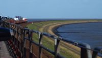
The most dominant green/blue infrastructure at Sylt's biggest settlement Westerland can be found along the coast line. A continous corridor of sandy beach and dunes forms a north-south connection at the western side of the town. Pathways are leading through this landscape. Thereby nature can be experienced by the residents. It is unlikely that this important green/blue infrastructure will disappear in cause of building activity. Although there is an extreme pressure on land and housing, this area is strictly protected by nature reserves. The risk of loosing this area is displayed by nature itself. Tides and storms permanently wash away the land and push the coast line towards the settlement.
-
 green/blue infrastructure connection along the coast at Westerland
 -
 walkway along the natural coast at Westerland


Actors and stakeholders
- Who is driving changes in this landscape? Who is affected by those changes?
- Draw a stakeholder and/or power map: Who is affected highly but with low power? Who has high power but is not affected?
-
 power map

Sacred spaces and heritage
- Which places/elements hold cultural value and to whom?
- You may add a map and some images, please also explain in your caption why these elements are valuable
Sylt has to offer various sacred places and cultural heritage. Very characteristic for the island's villages is the 'Friesenhaus', the traditional house with the typical roof made of reeds. However these houses became rare due to the big pressure on housing. People already settled on Sylt since the Stone Age. There are 47 megalith areas on Sylt. These are acient burial mounds. One of the most impressive one is 'Denghoog' near Wenningstedt. From the Iron Age some castles remained on Sylt. The best preserved one is 'Tinnumburg'. They were propably used as sanctuaries. Also World War 2 left its traces on the island. Various bunkers can be found along the coast, the most remarkable is 'Bunker Hill'. All these places are strongly connected to the island's rich history. Without them the unique identity of Sylt would be lost, which would be disastrous for both, tourists and the local population.
-
 map with sacred places
 -
 'Friesenhaus' traditional house
 -
 remains of 'Tinnemburg', Iron Age
 -
 bunker of World War 2


Visual appearance and landscape narrative
- Which elements are essential for the landscape character?
- Has the landscape been painted or otherwise depicted, when and whom? Which elements are essential?
- Which narratives exist? Who has written about this landscape or depicted it in some way?
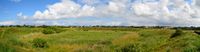
The landscape on Sylt is mainly characterized by long sandy beaches with the typical dunes overgrown by grass. Very common along the beaches are so called 'Buhnen', erosion control measures. They are supposed to break the force of the incoming waves. Especially the old ones made of wood are very picturesque and have a strong influence on the appearance of the landscape. Also lighthouses are a very common and typical sight at the coast. All the while this landscape has attracted many painters and writers who were strongly inspired by the untamed and wild scenery. In most of the paintings the described landscape elements play an essential role, as well as in several books and writings. It seems that Sylt offers the perfect setting for novels, since there are numerous available.
-
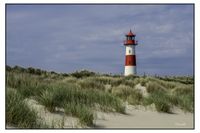 lighthouse
 -
 typical dune next to the beach
 -
 'Buhne'


A.2 Summary of you landscape system analysis and your development Targets
- You can summarize your findings with an DPSI(R) Model or a Spider Diagram
- Link back to the Sustainable Development Goals: Which goals are at risk?
- What is your hypothesis for this landscape?
- Visualise your hypothesis with one graphic/pict
- Are there any existing initiatives taking action in this landscape? Do you have a critical perspective on that?
- Add text and visuals
Especially there are two Sustainable Development Goals at risk: 1. Reduced Inequalities: Because of the 'invasion' of the tourists and wealthy people buying holiday houses on Sylt, the local population is driven out of their home, because they can no longer affort the exploding living expenses. 2. Life on Land: Because of the constantly loss of land, Sylt is endangered to be washed away by the sea, which will make life on the island impossible.
For both issues some counter measures were initiated. The construction of holiday homes got restricted by the local polititians. New buildings or buildings which shall be transformed into holiday houses must provide at least 40% of their living space for permanent residents. Thereby it shall get easier for the local population to find affordable apartments for living on the island. But this affects only few buildings and the effect is not that high. Against the loss of land people are fighting with varous measures. However the most successful one is to pump sediment from the seafloor to the island's coast. This is an never ending process because the newly installed sand will be washed away by the next storm tide. Of course this measure causes tremendous costs of 10 million euros a year, which is funded by the state and the EU.
-
 Tourism is the key actor on Sylt. The mass tourism causes huge pressure son the local housing, the living expenses and also on the nature. On the other hand the local economy depends on the tourists for jobs and income. Also the costly coast protection is partly financed and justified by the huge touristic value of Sylt.

-
 If the driving forces continue as they do, Sylt will face two major threats: At first, the island is likely to become a destination for vacation only, because the locals cannot affort to live on Sylt anymore. Another threat are more intensive storm tides, caused by the climate change which will seriously damage the coast and the island.

A.3 Theory reflection
- Reflect on an international policy document in relation to their local landscape case
Natura 2000 is a network of protected breeding and resting sites for endangered species all over europe. By covering 18% of EU territory it is the largest protection network in the world. The goal is to foster a sustainable land use and a compatible nature protection. Also on Sylt there are Natura 2000 areas established. This is very important due to the island's importance of breeding places for many rare bird species. The protected areas ensure the persistence of these species but also allows tourism. This balance of strict nature protection and human activites and economy is a key element of the success of Natura 2000 areas. Because of this balance nature protection is more likely to be accepted by people than strict nature reserves where the human being is totally excluded and not even allowed to enter.
A.4 References
- https://de.wikipedia.org/wiki/Sylt
- https://www.focus.de/immobilien/bauen/wohnraum-wird-knapp-sylt-schraenkt-bau-von-ferienwohnungen-ein_id_5459461.html
- http://ec.europa.eu/environment/nature/natura2000/index_en.htm
Phase B: Landscape Evaluation and Assessment
B.1 Assessment Strategy
The Landscape System Analysis identified two major problems: The constant loss of land and the gentrification process in cause of rising living expenses. The assessment strategy will focus on the loss of land, which states a major threat for the island's future. At the moment coastal protection on Sylt is done by common methods. Big bunker ships are gathering sediment from the sea floor in front of the island. The collected sand is deposited along the coast and gets distributed by bulldozers. This method is very costly and must be repeated frequently.
In the Netherlands an innovative "building with nature" experiment was initiated, the so called "Zandmotor", sand engine in English. This is an artificially raised hook shaped peninsula at a certain location of the coast. The aim was that nature can distribute the sand in a natural and more efficient way by using the sea currents. The project was a big success and could be also an effective solution for Sylt. For identifying a suitable location for this measure it is essential to consider the sea currents around the island of Sylt. Furthermore it is important to know about the places where currently the sand is wahsed away from the coast. Therefore these two issues must be mapped. This can be done by assessing online data.
Another issue poses the historic coastal protection measures, the groynes (ger: Buhne). These are low walls built out from the coast into the sea and very common on the coastline of Sylt. They are supposed to break the force of the incoming waves and reduce the loss of sediment. The problem is, these artificial obstacles cause strong cross flows which prevent natural sand deposits. For a successful natural coast protection the groynes must be removed and thereby for this assessment also mapped. This mapping can be done by analyzing aerial photos.
B.2 Mapping
- As defined by your assessment strategy you conduct the mapping and present your findings here
- As a minimum, at least three different themes need to be mapped, you may choose more if needed
-
 The prevailing sea current at Sylt's west coast is the 'Jutland Stream' heading from south to north, thereby sand is likely to be spread also into that direction
 -
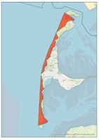 This map shows the loss of land along the west coast during the years 1870 till 1984 (Representation exaggerated 1000 times). Especially in the northern and southern exposed parts of the island there is a huge amount of sand washed away by the sea.
 -
 This map shows all groynes along the west coast. The highest density can be found in close proximity to settlements.


B.3 Problem definition and priority setting
- Give a summary of the major findings of your mapping process, what are the problems/potentials identified?
- Draw a problems/potentials map
- Set priorities for the most relevant issues
-
add caption here
B.4 Theory reflection
- Please reflect the assessment and evaluation methods used based on at least three readings
- Did you encounter limitations'
- 200 words test contribution
B.5 References
- http://www.dezandmotor.nl/en/research/results-after-five-years/
- https://www.schleswig-holstein.de/DE/Fachinhalte/K/kuestenschutz_fachplaene/Sylt/1_2_einleitung_entwicklung.html
- https://de.wikipedia.org/wiki/Norwegischer_Strom
Phase C – Strategy and Master Plan
C.1 Goal Setting
- Define strategic planning objectives based on the evaluation findings
- Link back to your original targets from section one and the Development Goals
- 150 words text contribution
C.2 Spatial Strategy and Transect
- translate your strategic goals into a vision
- develop a spatial translation of your vision
- exemplify your vision in the form of a transect with concrete interventions
- add map(s) and visualizations
-
add caption here
-
add caption here
-
add caption here
-
add caption here
C.3 From Theory of Change to Implementation
- For implementing your vision: Which partnerships are needed? Which governance model is required?
- Who needs to act and how? Draw and explain a change/process model/timeline
- Which resources are needed? On which assets can you build?
- add 150 words text and visuals
-
add caption here
-
add caption here
C.4 References
- give a full list of the references you have used for this section
D. Process Reflection
- Reflect in your intercultural and interdisciplinary team on the outcomes of your study
- Which limitations were you facing?
- What have you learnt from each other?
- What would you do differently next time?
- You can also use diagrams/visuals
- 250 words text