Caspian Sea Nur Beach: Difference between revisions
| Line 118: | Line 118: | ||
<gallery caption=" " widths="500px" heights="200px" perrow="1"> | <gallery caption=" " widths="500px" heights="200px" perrow="1"> | ||
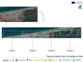
File:Mapping Fardokht and Yasaman.JPG|''With the purpose of more detailed theme maps, the plan of Nur Beach has been divided into four portions.'' | File:Mapping Fardokht and Yasaman.JPG|''With the purpose of more detailed theme maps, the plan of Nur Beach has been divided into four portions.'' | ||
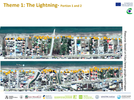
File:Mapping | File:Mapping them1 Fardokht and Yasaman.png|''In the following map, by the density of the yellow duts, the quality of the current lightning has been shown. Although in front of the residential constructions there are lightnings, but there are lots of places beside of the sea without proper light during the night.'' | ||
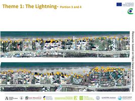
File:Mapping | File:Mapping them1-2 Fardokht and Yasaman.jpg|''As it gets closer to the east part of Nur County, the number of the planned and designed areas with propet lightning on the edges, increase.'' | ||
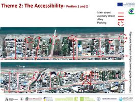
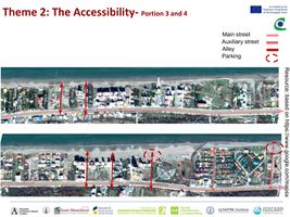
File:Mapping | File:Mapping them2 Fardokht and Yasaman.jpg|''There are many street connections, in different widens which connect the main east-west street to the beach, although most of these streets are not equipped by proper pedestrian paths.'' | ||
File:Mapping | File:Mapping them2-2 Fardokht and Yasaman.jpg|''The end of most networks connections-between the free space of the street and the beach- have been used by people as parking areas.'' | ||
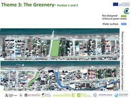
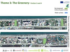
File:Mapping | File:Mapping them3 Fardokht and Yasaman.jpg|''On these maps the current green areas have been shown. Also the water surface as an area with potential has been colored. There are also lots of green areas in the private territories which are usually surrounded by the territory walls.'' | ||
File:Mapping | File:Mapping them3-2 Fardokht and Yasaman.jpg|''Perhaps it could be said the function of being a green space, have been defined for many of these areas, but not all of them have been designed, which as a result some of them -specially the unbounded areas- can be considered as risks of having low maintenance and low safety.'' | ||
</gallery> | </gallery> | ||
| Line 131: | Line 131: | ||
<gallery caption=" " widths="500px" heights="200px" perrow="5"> | <gallery caption=" " widths="500px" heights="200px" perrow="5"> | ||
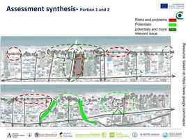
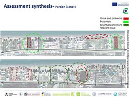
File:Risk and potentials Fardokht and Yasaman. | File:Risk and potentials 1 Fardokht and Yasaman.jpg|''In fact those areas with higher number of ‘green lines’, have the highest potential and areas higher number of ‘red lines’, have the highest risk.'' | ||
File:Risk and | File:Risk and potentials2 Fardokht and Yasaman.jpg|''The lack of proper lightning can result the risk of lack of safety and also low quality of the space, which such situation is happening between of some of the residential areas. Also having the parking lots in the open spaces between the end of the streets can reduce the quality of the open space as well.'' | ||
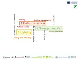
File:Priorities and Targets Fardokht and Yasaman.JPG|''Locating main poles in Nur Beach, finding comprehensive solutions to supply the lacks, strength the potentials such as designing and make a proper plan for abounded green area, defining parking areas based on the location of the poles and streets connections, providing bicycle and pedestrian access to Nur Beach and , providing proper lightning are our major priorities.'' | File:Priorities and Targets Fardokht and Yasaman.JPG|''Locating main poles in Nur Beach, finding comprehensive solutions to supply the lacks, strength the potentials such as designing and make a proper plan for abounded green area, defining parking areas based on the location of the poles and streets connections, providing bicycle and pedestrian access to Nur Beach and , providing proper lightning are our major priorities.'' | ||
Revision as of 05:50, 18 May 2018
>>>back to working groups overview
| Area | Caspian Sea, North of Iran | |
| Place | Nur Caunty | |
| Country | Iran | |
| Topics | Nur Beach | |
| Author(s) | Yasaman Rahimi, Fardokht Hadji Salimi | |
| ||
Rationale
- Why do you think this case is relevant? What is your hypothesis considering the landscape challenges?
- Format: 3-4 sentences
Location and scope
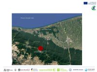
You can edit this map with the map editor
A Landscape System Analysis
A.1 Landscape layers and their system context
Geomorphology, landscape units and coastal typology
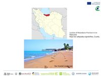
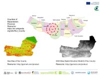
In Nur the Green & Blue are besides. Nur County by having beautiful parts of Caspian sea is one of the most important tourism regions in Iran and the touristic development of this city has been considered in the plannings of the government. Our hypothesis: Potential to be one of the largest coland tourism poles of Iran
Land use
- Yourcase landscapeunit3.jpg
add a caption
Green/blue infrastructure
- Your case green blue infrastructure2.jpg
add a caption
Actors and stakeholders
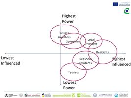
It can be said a big part of the changes in this region is caused by new constructions.Here are the explanations about some of the named groups in the following Power Map:_Private Investors: Those who invest but do not leave in Nur_Local Investors: Those who invest and leave in Nur._Seasonal Residents: Those who have a house in Nur, but they leave in other cities in most of the seasons_Tourists: Those who do not have a house in Nur and come to visit this city.
Sacred spaces and heritage
- Your case sacredspace3.jpg
add a caption
Visual appearance and landscape narrative
Resource: http://tripbama.com/fa/ Access : 18.04.2018
- Your case character3.jpg
add a caption
A.2 Summary of you landscape system analysis and your development Targets
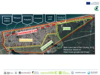
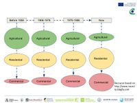
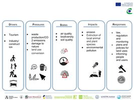
If the current situation goes on, more and more agricultural lands will be changed to commercial and residential buildings and based on low functional management, results such as air pollution, water pollution, low diversity and decrease of health of the society would occur.BUT by having a multi aspect planning and a functional management system, considering precious natural resources and future generation, Nur can become one of the great tourism poles of Iran.
A.3 Theory reflection
- Reflect on at least three international policy documents in relation to their local landscape case
- choose one international, one European and one national document
- You can choose references from our reading list
- Scope: 250 words
A.4 References
- give a full list of the references you have used for this section
Phase B: Landscape Evaluation and Assessment
B.1 Assessment Strategy
- Based on the hypothesis derived from your previous landscape systems analysis you are now asked to define the goals for assessing the landscape. Your assessment is the basis for evaluating the landscape status.
- Which elements and phenomena need to be mapped, why and how?
- This a text contribution, max 250 words
B.2 Mapping
B.3 Problem definition and priority setting
- In this level, three different layers of each portion have been overlapped. Therefore it can be seen the places which have lacks and problems (in the three themes of Lightning, Accessibility and Greenery). The places which have the boldest potentials, demonstrated by having multiple layers on them.
The lack of proper lightning can result the risk of lack of safety and also low quality of the space, which such situation is happening between of some of the residential areas. Also having the parking lots in the open spaces between the end of the streets can reduce the quality of the open space as well.
Locating main poles in Nur Beach, finding comprehensive solutions to supply the lacks, strength the potentials such as designing and make a proper plan for abounded green area, defining parking areas based on the location of the poles and streets connections, providing bicycle and pedestrian access to Nur Beach and , providing proper lightning are our major priorities.
B.4 Theory reflection
- Please reflect the assessment and evaluation methods used based on at least three readings
- Did you encounter limitations'
- 200 words test contribution
B.5 References
- give a full list of the references you have used for this section
Phase C – Strategy and Master Plan
C.1 Goal Setting
- Define strategic planning objectives based on the evaluation findings
- Link back to your original targets from section one and the Development Goals
- 150 words text contribution
C.2 Spatial Strategy and Transect
- translate your strategic goals into a vision
- develop a spatial translation of your vision
- exemplify your vision in the form of a transect with concrete interventions
- add map(s) and visualizations
- Your case spatial translaton vision.jpg
add caption here
- Your case transect.jpg
add caption here
- Your case transect detail1.jpg
add caption here
- Your case transect detail2.jpg
add caption here
C.3 From Theory of Change to Implementation
- For implementing your vision: Which partnerships are needed? Which governance model is required?
- Who needs to act and how? Draw and explain a change/process model/timeline
- Which resources are needed? On which assets can you build?
- add 150 words text and visuals
- Your case spatial your governance model.jpg
add caption here
- Your case spatial your process model.jpg
add caption here
C.4 References
- give a full list of the references you have used for this section
D. Process Reflection
- Reflect in your intercultural and interdisciplinary team on the outcomes of your study
- Which limitations were you facing?
- What have you learnt from each other?
- What would you do differently next time?
- You can also use diagrams/visuals
- 250 words text
