Son Tra Peninsula: Difference between revisions
| Line 131: | Line 131: | ||
= Phase B: Landscape Evaluation and Assessment = | = Phase B: Landscape Evaluation and Assessment = | ||
== B.1 Assessment Strategy == | == B.1 Assessment Strategy == | ||
''In terms of the assessment strategy, my main goals are:'' | |||
*'' | *''To identify how the land-use of the peninsula changed overtime.'' | ||
*'' | *''Factors affecting these changes.'' | ||
*''The risks may be caused by these changes.'' | |||
*''To develop strategies to protect the values of this area.'' | |||
''Following these goals, there are two main themes in my presentation today. The first theme is land-use change in this area and with the second theme I would like to find out the economic value of the landscape system in this peninsula.'' | |||
== B.2 Mapping == | == B.2 Mapping == | ||
Revision as of 07:29, 24 May 2018
>>>back to working groups overview
| Area | Son Tra Penisula | |
| Place | Danang | |
| Country | Vietnam | |
| Topics | tourism, nature protection | |
| Author(s) | Duy Phan Do | |

| ||
Rationale
- Why do you think this case is relevant? What is your hypothesis considering the landscape challenges?
Vietnam has a long coastline with many beautiful beaches. But the reason I chose Son Tra peninsula is that it is a rare place to include many features such as ecological, tourism sacred and historical value. However, it is also facing some problems and needs strategies for sustainable development.
Location and scope
You can edit this map with the map editor
A Landscape System Analysis
A.1 Landscape layers and their system context
Geomorphology, landscape units and coastal typology
- Description of evolution, status quo and driving forces, is the coastal typology changing? Why is that? (approx 200 signs)
Son Tra peninsula is located in Danang one of the famous tourist city in my country. In the past, Son Tra was an island of three high mountains. Over a long time, the acquisition I don’t know what it is exactly called but it has created the area to connect land to the island. Nowadays, this peninsula becomes an attractive destination with many beautiful beaches. As you can see in the picture is a typical structure of the peninsula with mountains, forests, sandy beaches, and coastline.
-
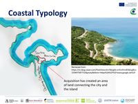 Coastal Typology
 -
add a caption

Land use
- settlements, infrastructure, agriculture, resource extraction, natural areas, energy production...
- description of evolution, status quo and driving forces, is the land use likely to change? Why is that? (approx 200 signs)
This is the land-use map of Danang city. We can see that in the right corner is the peninsula with most of the forest and scrub. Looking at the changes in land use of Danang in general, the area of the building, shown in red, has increased significantly. The density of the building is also higher on the area connecting the city with the peninsula. Even some green area of the peninsula has been narrowed.
-
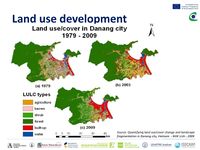 Land use development
 -
add a caption

Green/blue infrastructure
- What are the major potential elements of a green/blue infrastructure network? Are these likely to change/disappear? Why is that?
- You find my background material on green infrastructure in our reading list
Zooming in the green and blue infrastructure of the peninsula, it is mainly surrounded by the sea. Most of the area is forested, grassland and shrub. That made the peninsula to become a natural forest ecosystem associated with the sea in the heart of a modern city. Besides on the beach still retaining the natural beauty, this is also home to the world's largest population of endangered red-shanked doucs as well as many other species.
-
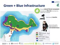 Green + Blue Infrastructure
 -
add a caption

Actors and stakeholders
- Who is driving changes in this landscape? Who is affected by those changes?
This is the power map to show the affected stakeholders and actors. In my case and my opinion, The most powerful actors are government and the investors. The actors that are the most affected and have the least power are the local population including the species and their habitats
-
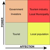 Power map

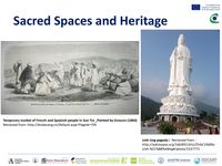
Sacred spaces and heritage
- Which places/elements hold cultural value and to whom?
Besides the ecological and tourism value, the peninsula also has the sacred and historical values. This has known as the first place where French colonialists attacked Vietnam in 1858 and started the French-Vietnam War. On the left is a picture of a Temporary market of French and Spanish people in Son Tra peninsula. There is also a pagoda with many legends and stories for those who believe in.
-
 Sacred spaces and heritage
 -
add a caption
-
add a caption

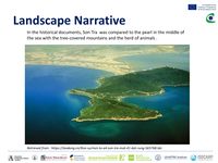
Visual appearance and landscape narrative
- Which elements are essential for the landscape character?
- Has the landscape been painted or otherwise depicted, when and whom? Which elements are essential?
- Which narratives exist? Who has written about this landscape or depicted it in some way?
Son Tra peninsula was described In the historical documents with natural and original beauty. It was compared to the pearl in the middle of the sea with the tree-covered mountains and the herd of animals.
-
 Landscape Narrative
 -
add a caption
-
add a caption

A.2 Summary of you landscape system analysis and your development Targets
- You can summarize your findings with an DPSI(R) Model or a Spider Diagram
- Link back to the Sustainable Development Goals: Which goals are at risk?
- What is your hypothesis for this landscape?
- Visualise your hypothesis with one graphic/pict
- Are there any existing initiatives taking action in this landscape? Do you have a critical perspective on that?
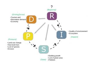
DPSIR model to show what drives the landscape and its changes, what is the pressures and state of the site, what impacts occur following these changes. Located close to the city center and easily accessible is the advantage and disadvantage. It has to face the drivers and pressures like tourism and recreation demand, economic development, changes in land use, loss of species and the problems of nature. The state we can start to see is the growth of the buildings, lost of some green areas and pollution. As a result, These will impact the quality of environment and ecosystem. So what could be the responses?
-
 DPSI(R) model

-
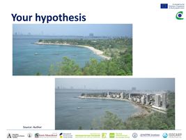 A picture I think might happen in the far future with a bad scenario. Without the conservation and sustainable development strategies, it is possible that green areas on the peninsula will be replaced by the buildings, ecosystems and living environment of the species will be destroyed.

A.3 Theory reflection
- Reflect on at least three international policy documents in relation to their local landscape case
- choose one international, one European and one national document
- You can choose references from our reading list
- Scope: 250 words
A.4 References
- give a full list of the references you have used for this section
Phase B: Landscape Evaluation and Assessment
B.1 Assessment Strategy
In terms of the assessment strategy, my main goals are:
- To identify how the land-use of the peninsula changed overtime.
- Factors affecting these changes.
- The risks may be caused by these changes.
- To develop strategies to protect the values of this area.
Following these goals, there are two main themes in my presentation today. The first theme is land-use change in this area and with the second theme I would like to find out the economic value of the landscape system in this peninsula.
B.2 Mapping
- As defined by your assessment strategy you conduct the mapping and present your findings here
- As a minimum, at least three different themes need to be mapped, you may choose more if needed
-
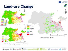 briefly explain the findings of your mapping
 -
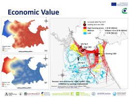 briefly explain the findings of your mapping
 -
briefly explain the findings of your mapping


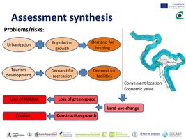
B.3 Problem definition and priority setting
- Give a summary of the major findings of your mapping process, what are the problems/potentials identified?
- Draw a problems/potentials map
- Set priorities for the most relevant issues
-
 add caption here
 -
 add caption here


B.4 Theory reflection
- Please reflect the assessment and evaluation methods used based on at least three readings
- Did you encounter limitations'
- 200 words test contribution
B.5 References
- give a full list of the references you have used for this section
Phase C – Strategy and Master Plan
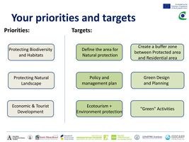
C.1 Goal Setting
- Define strategic planning objectives based on the evaluation findings
- Link back to your original targets from section one and the Development Goals
- 150 words text contribution
C.2 Spatial Strategy and Transect
- translate your strategic goals into a vision
- develop a spatial translation of your vision
- exemplify your vision in the form of a transect with concrete interventions
- add map(s) and visualizations
-
add caption here
-
add caption here
-
add caption here
-
add caption here
C.3 From Theory of Change to Implementation
- For implementing your vision: Which partnerships are needed? Which governance model is required?
- Who needs to act and how? Draw and explain a change/process model/timeline
- Which resources are needed? On which assets can you build?
- add 150 words text and visuals
-
add caption here
-
add caption here
C.4 References
- give a full list of the references you have used for this section
D. Process Reflection
- Reflect in your intercultural and interdisciplinary team on the outcomes of your study
- Which limitations were you facing?
- What have you learnt from each other?
- What would you do differently next time?
- You can also use diagrams/visuals
- 250 words text