Aqaba Gulf: Difference between revisions
| Line 218: | Line 218: | ||
== B.5 References == | == B.5 References == | ||
* | * http://moocs.unige.ch/liste-de-cours/liste-des-cours-3/ecosystem-services-a-method-for-sustainable-development/ | ||
=Phase C – Strategy and Master Plan = | =Phase C – Strategy and Master Plan = | ||
Revision as of 09:11, 27 May 2018
>>>back to working groups overview
| Area | Aqaba Gulf | |
| Place | Aqaba | |
| Country | Jordan | |
| Topics | Tourism Industry | |
| Author(s) | Mohammad, Nawar & Reem | |

| ||
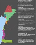
Rationale
- Aqaba is a primary tourist destination for locals and foreigners and one of the key diving locations in the world, due to its world-known coral reefs. In addition, the Gulf of Aqaba is the only seaport in the country of Jordan, which led to the presence of international trade in the area. Moreover, it is considered as international waters with Israel which is raising political conflicts and competitions in tourism strategies in the past few years. These factors are demanding and leading to an accelerating economic development to transform the area into a sustainable economic growth and touristic engine for the country, leaving heavy pressures on the coastal landscapes in the area, and as a result, it has raised our curiosity to understand the coastal landscape management plan in the area.
Location and scope
You can edit this map with the map editor
A Landscape System Analysis
A.1 Landscape layers and their system context
Geomorphology, landscape units and coastal typology
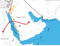
The Gulf of Aqaba (GOA) is one of the two waterways that originate from the northern margin of the Red Sea, which is about 165 kilometers long, with an average width of 20 kilometers and 800 meters deep. It is also a developing rift at the southern end of the dead sea transform system. The whole structure is a part of the Syrian–African rift valley, which is flanked by a mixture of mountains and deserts both to the east and the west. The southern end of this important waterway is separated from the Red Sea by a shallow sill at the Straits of Tiran. The Fossil reefs indicate that in the past 7000 Years the Red Sea level was stable and vertical tectonic movements were negligible. Geological Studies indicate sedimentary structures from two trenches dug in beach sediments buried and emerged fossil reefs and the local submarine slope morphology. The GOA has been subject to rapid changes due to the Urban and industrial expansions, as well as, the dramatic appearance of Touristic resorts along the shoreline.
-
 The Earliest Settlement was for the sake of Trade with the country of Eygpt and neighboring countries.
 -
 The development stage after was in the heart of the city-the city center-and embraces the retail shops and the old residential units.
 -
 In this development stage, urban settlements have expanded to the eastern side of the shoreline and the main highway connecting Aqaba to the surrounding city has been constructed. Also, a port has been constructed to the southern end of the shoreline.
 -
 Dense urban settlements have been constructed form the heart of the city moving upwards to the northern side of the shoreline.
 -
 A new port has been constructed in the middle area of the shoreline, in this stage. And more urban settlements have been constructed towards the northern part of the city.
 -
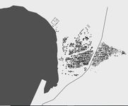
 This map demonstrates the current state of the city, more urban settlements to the northern part of the city and some minor changes in the shoreline have taken place.


Land use
-
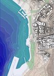
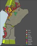 This Map illustrates the different land-uses in the city of Aqaba, and it is easy to notice that the Recreational/Touristic facilities are centralized in along the shoreline, whereas the residential units are located in the heart of the city far from the shore. And this map also shows that there are several Archaeological sites that hold historical and religious values.
 -
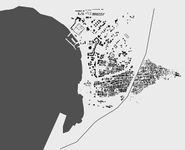
 A zoomed-in map in the heart of the city, taken from the ASEZA booklet, showing the residential areas in yellow and the resorts in light red.
 -
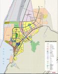
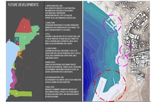
 Mapping the future developments, made our hypothesis easier to predict due to the huge changes in the coastline in the areas 3,4,5 and 6.
 -
 This map illustrates the environmental constraints in the area, which is categorized in terms of their sensitivity as; High: globally threatened flora or fauna are found and where changes to the site could affect their survivability, Medium: endangered species are found, that is regionally or locally sensitive, and Low: natural or semi-natural areas with a good representation of local species.
 -
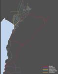 The different hierarchy in the vehicular routes that varies from a highway to local -One lane- roads.
 -
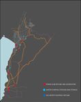 This map demonstrates the energy (Electrical power) production locations, and the energy produce varies from 30 Megawatt in the southern end of the shoreline in the industrial zone, to 600 Megawatt generated through a marine cable to Eygpt. Also, it demonstrates the water pumping locations and storage points, the main source of water in Aqaba is the Disi Aquafier.


Green/blue infrastructure
- What are the major potential elements of a green/blue infrastructure network? Are these likely to change/disappear? Why is that?
-
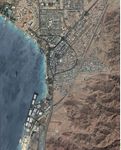 An aerial view of Aqaba city showing the Red Sea as the blue infrastructure and the green infrastructure can only be seen in the median island in the main streets and also it can be seen along the shoreline, specifically in front of the main entrances of the resorts to create an inviting landscaped entrance for the guests.
 -
 The green infrastructure has been demonstrated according to our perception because we have noticed that the Green infrastructure is only located parallel to the shoreline where the 5 stars resorts are, whereas in the other areas in the city it is not given any attention.


Actors and stakeholders
- The main driving forces behind the change of the Landscape in Aqaba are the Aqaba Special Economic Zone (ASEZA) which is the main authority body in the city, as well as, the investors and the shareholders who are dramatically investing in the Recreational and Touristic sector. Local residents are the most affected by these changes since all the public beaches are now being transformed into 5 Stars resort beaches, which can only be used by the resorts' guests.
-
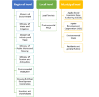 This Diagram illustrates the Stakeholders on the Regional, Municipal and local levels, and it is important to mention that the Aqaba Special Economic Zone Authority (ASEZA) acts as a separate authority body, whereas other ministries act on a Regional level.
 -
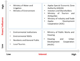 This Powermap demonstrates the interested parties and their power in terms of Touristic and Recreational developments taking place in Aqaba city
 -
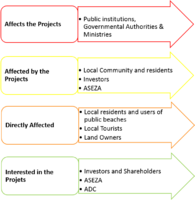 This Diagram also represents the Stakeholders but in terms of the level of impact and effect.


Sacred spaces and heritage
- Aside from the diving tourism which Aqaba is famous for, there are several sites with religious, historical and cultural values to the locals and tourists, and some tourists come from Eilat and other neighboring countries to celebrate these sites.
-
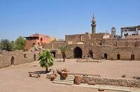 Mamluk Castle or Aqaba Fortress, a 16th century partially built castle that served as a military site and caravanserai for traveling pilgrims to Mecca. A castle that dates back to the Arab revolt time.
 -
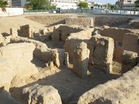 Aqaba Church is the world's oldest purpose-built Christian church dating back to the third century. One of the last destinations that tourists usually make a visit to after their route that starts all the way from Wadi Rum.
 -
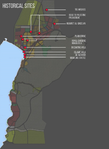 A map that shows the Roman, Byzantine, Mamlouk and Islamic Heritage sites that are valuable landscape elements for the locals and the tourists.


Visual appearance and landscape narrative
- There are several elements that characterize the landscape such as the high mountains surrounding the city, the sandy desert and the Red Sea with its rich coral reef.
-
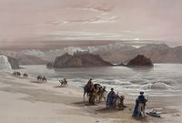 Isle of Graia Gulf of Akabah Arabia Petraea, 1839 lithograph of a trade caravan by Louis Haghe from an original by David Roberts. The painting depicts the desert like coastal landscape that is very special and related to the region. Showing the rocky mountains which are famous in Jordan's desert as well as Aqaba's background from the coast. The choice of brown tone colors to make the desert-like coastal landscape more vivid brings the atmosphere closer to the imagination.
 -
 Trade along the red sea has happened as early as the fourth Egyptian Dynasty. The early homo sapiens have also always taken the coastal routes due to the coastal resources and proof to that is the presence of the many archaeological sites located along the entire edge of the Red Sea Rift, starting from the very northern gulf of Aqaba up until the most southern African parts
 -
 The ancient city of Ayla (in present-day Aqaba) was a commercial hub for the Nabateans. The Romans built the Via Traiana Nova, which joined the King's Highway at Aqaba and connected Africa to Asia and the Levant and Red Sea shipping.
.jpg)


A.2 Summary of you landscape system analysis and your development Targets
The goals that according to our drivers could be at risk include numbers 13, 14, and 15. Starting with climate action that has not been brought up by any of the local related parties. No action from local community or authorities is being taken towards the risks that are caused by the climate change that in return affect goal number 14 which is the life under water. Coral reefs dating back to more than 6000 years ago are at huge risk with all the encouraged increasing tourism in the area. Goal number 15, life on land, is another one at risk as to attention only given to the areas near the coast and the huge investments done there while excluding many people from their right to access and experience the coastal landscape
-
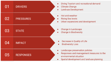 The most important drivers in Aqaba's landscape are the increasing tourism demands that are formulating in forms of fancy resorts and huge projects that put a lot of pressure on the biodiversity in the region as well as the land use development that of course follows the previous driver. Climate change is a huge driver that is also causing rising in sea levels and increasing evaporation, needless to mention that the evaporation rates in the red sea are the highest in the world. The pressures of the hot arid weather, the rising sea levels, and the urban development are resulting in landscape and biodiversity change and the impact could be a huge loss of biodiversity. The Gulf of Aqaba's coral reefs are under a lot of risks, they are also known worldwide for the variety and beauty. Another impact, of course, is the decrease in the quality of life of the locals.

-
 Based on the DPSIR Model, we hypothesized that the Landscape of Aqaba city would be subject to severe changes due to the rising demands on recreational facilities and the diving tourism, aside from the climate change which is not attracting enough authority's attention until this day. This would lead to the change of biodiversity and of course, would result in the damage and the loss of the coral reefs. Also, the industrial zone of Aqaba has been relocated from the middle area along the shoreline to the southern end of the shoreline, and therefore we have hypothesized that the industrial zone might also be subject to expansions, which could result in pollution and environmental degradation.

A.3 Theory reflection
1. UNDP, GEF and ASEZA, National Aqaba Ecotourism Development Plan (2014) - National Policy
A document prepared as a guideline for the project of Mainstreaming Marine Biodiversity Conservation into Coastal Zone Management in Aqaba. The most important guidelines were related to the promotion of Biodiversity friendly investments, as well as, the biodiversity conservation and coral reef protection plan, which had been partially applied in some of the coastal resorts constructed during the years 2015 - 2017, and some resorts have not applied these guidelines such the Ayla Project.
2. ASEZA, Aqaba Translocation Project Plan (2012) - National Policy
The heavy and continuous multi-use of the Aqaba Gulf in Tourism and industry have resulted in great load and damage of the coral reefs and demanded the authorities' attention to initiate guidelines for using the coastline feasibly but at the same time to conserve its environmental value. Therefore, and based on the guidelines listed in this plan part of the coral reef has been translocated to the Marine Park of Aqaba and the industrial zone has been moved to the most southern part of the coast.
3. EU Nature Protection Policy, European Commission Natura 2000 - European Policy
The goal of this policy is to stop the loss of Biodiversity on the European and the global scale by the year 2020, due to its importance to both our health and economy. Therefore, in 2011, the EU has adopted a strategy listing 6 targets and 20 actions to reach its goal of protecting the ecosystem and its services. And over the past 25 years, they have built the largest network of protected areas in the World known as Natura 2000, and their understanding is that protection alone is not enough so they have connected these PAs using green infrastructure to restore the ecosystem services and allow the different species to thrive across the EU's outstanding achievement Natura 2000. Similar to this, the Royal Society for the Conservation of Nature has suggested 11 sites as SPA "Suggested Protected Areas", and 18 as PA "Protected Areas" but has but has not created a green infrastructure network yet. But it is currently working on strategies to protect the coral reefs of Aqaba Gulf and doing an EIA "Environmental Impact Assessment" of the industrial zone expansion. The Natura 2000 strategies could be used as a reference.
4. EU Water and Marine Policy, European Commission Marine Strategy Framework Directive - European Policy
This marine directive framework was the first EU legislation that aimed at the protection of the marine life and the natural resources and creating a framework for the sustainable use of marine waters. The EU coastal and marine policy is trying to protect the waters from the several and complex issues that the marine waters is facing. Pollution from sources on land and in ocean is causing a lot of pressure on the coastal zones. There have been many attempts in trying to protect the marine and coastal environments through the EU legislation which has been implemented in many areas, like for example the Common Fisheries Policy or the Water Framework Directive.
This directive’s main goal is to achieve the Good Environmental Status (GES) of Europe’s waters by 2020. The protection of the waters is important as it is the base of which marine-related economic and social activities depend on. The directive’s aim of biodiversity maintenance shows its containment on how it affects human activities and in return have an impact on the marine environment.
The marine directive establishes the European region and sub regions based on the geographical and environmental criteria and it lists four main regions: The Baltic sea, the North-East Atlantic Ocean, the Mediterranean Sea and the Black Sea. In order to reach the GES by 2020, the member states are required to develop a marine strategy, and because the directive follows an adaptive management approach, the strategies must be kept up to date and reviewed every 6 years.
5. UN HABITAT, International Guidelines on Urban and Regional Planning - International Policy
"Due to the rapidly world changing and the growing in urban population which has reached 3.96 billion in 2015,In response to that transformation, the International Guidelines on Urban and Territorial Planning (the Guidelines) are intended to be a framework for improving global policies, plans, designs and implementation processes, which will lead to more compact, socially inclusive, better integrated and connected cities and territories that foster sustainable urban development and are resilient to climate change."
"The goals of the Guidelines are:
- To develop a universally applicable reference framework to guide urban policy reforms.
- To capture universal principles from national and local experience that could support the development of diverse planning approaches adapted to different contexts and scales.
- To complement and link to other international guidelines aimed at fostering sustainable urban development.
- To raise the urban and territorial dimensions of the development agendas of national, regional and local governments."
"The Guidelines should be used through the multiscale continuum of spatial planning:
- At supranational and transboundary level.
- At national level.
- At city-region and metropolitan level.
- At city and municipal level.
- At neighbourhood level."
6. United Nations, Sustainable Development Goals - International Policy
The 17 sustainable development goals of the 2030 Agenda for sustainable development which will be applied universally over the next 15 years seeks mainly to stir the efforts to end all forms of poverty and tackle climate change. Goals Numbers 13, 14 and 15 according to our case study could be used as references, with a main focus on number 14 which is The Life Below Water goal since it includes the climate change, coastlines and on how to conserve and sustainably use the seas and marine resources which is the main focus of our case study.
A.4 References
1. https://en.wikipedia.org/wiki/Aqaba_Church
2. https://www.bookingjordan.com/blog/aqaba-city-colorful-with-lots-of-things-to-offer
3. https://en.wikipedia.org/wiki/Aqaba_Fortress
6. Aqaba Ecotourism Development Plan, (2008).[PDF file]
7. http://coastalires.blogspot.com/2016/08/the-aqaba-adventure.html
9. https://www.solid-earth.net/7/965/2016/se-7-965-2016.pdf
10.https://jordantimes.com/news/local/new-studies-launched-aqaba-marine-coastal-environment
11.http://conferences.ju.edu.jo/sites/aic/Documents/AIC2014_booklet.pdf
12.http://www.jva.gov.jo/sites/en-us/Documents/Red_Sea_Study_Main_Report_Final_July_2013.pdf
13.https://d-nb.info/964257521/34
14.http://siteresources.worldbank.org/INTREDSEADEADSEA/Resources/ThetisRevisedBADReportPart2Dec2010.pdf
15.ASEZA MASTERPLAN 2001-2020, (2002).[PDF file]
16. Aqaba Translocation Project Plan, (2012). [PDF file]
Phase B: Landscape Evaluation and Assessment
B.1 Assessment Strategy
The goals and purpose of this landscape assessment are to gather, understand and synthesize the current environment and surroundings of the Gulf of Aqaba in order to develop a strategy that will enhance its reputation, conserve its biodiversity and promote its tourism.
Through examining and mapping themes related to ecosystem services with a focus on the Cultural and Recreational Services, land use development, the current and the future expansion and land use change, and finally, the last theme will be assessing Aqaba's proximity to neighboring foreign gulfs especially the Gulf of Eilat which is a huge threat to Tourism and Biodiversity. These Themes are directly related to the DPSIR which we have developed as part of our Analysis and will help us in defining goals and targets that will be used in the planning and design process.
B.2 Mapping
-
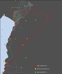
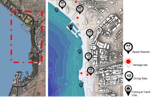 This map identifies the cultural ecosystems available in the Gulf of Aqaba, evaluating their importance given their locations but also pressures and potential risks they might be causing. Resorts, Industrial areas and more privatized recreational beach areas that are restricted to their specific visitors and not open to the general public.
 -
 Aqaba's coast provide a variety of uses and in return landscapes, each of which contributes to its coastal character. The coastal character of the gulf could be divided into layers where the shoreline starts with a beach and then extends towards the many resorts and royal lagoons and villas surrounded, then sweeping its way into the city and the rocky, rose colored mountains.
 -
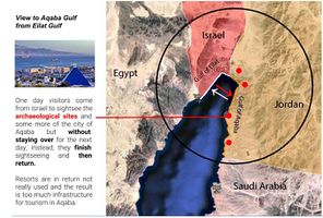 One day visitors come from Israel to sightsee the archaeological sites and some more of the city of Aqaba but without staying over for the next day, instead, they finish sightseeing and then return. Resorts are in return not really used and the result is too much infrastructure for tourism in Aqaba.


B.3 Problem definition and priority setting
-
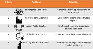 The potential dangers that could arise from the many services provided as well as the potential solutions to them.
 -
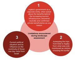 Limitations during the landscape assessment phase mostly related to involved authorities and the political situation.


B.4 Theory reflection
- Please reflect the assessment and evaluation methods used based on at least three readings
- Did you encounter limitations'
- 200 words test contribution
B.5 References
Phase C – Strategy and Master Plan
C.1 Goal Setting
- Define strategic planning objectives based on the evaluation findings
- Link back to your original targets from section one and the Development Goals
- 150 words text contribution
C.2 Spatial Strategy and Transect
- translate your strategic goals into a vision
- develop a spatial translation of your vision
- exemplify your vision in the form of a transect with concrete interventions
- add map(s) and visualizations
-
add caption here
-
add caption here
-
add caption here
-
add caption here
C.3 From Theory of Change to Implementation
- For implementing your vision: Which partnerships are needed? Which governance model is required?
- Who needs to act and how? Draw and explain a change/process model/timeline
- Which resources are needed? On which assets can you build?
- add 150 words text and visuals
-
add caption here
-
add caption here
C.4 References
- give a full list of the references you have used for this section
D. Process Reflection
- Reflect in your intercultural and interdisciplinary team on the outcomes of your study
- Which limitations were you facing?
- What have you learnt from each other?
- What would you do differently next time?
- You can also use diagrams/visuals
- 250 words text