Narva Jõesuu Town: Difference between revisions
| Line 86: | Line 86: | ||
<gallery caption=" " widths="500px" heights="200px" perrow="5"> | <gallery caption=" " widths="500px" heights="200px" perrow="5"> | ||
File:Power Map.jpg|''Power Map'' | File:Power Map.jpg|'''''Power Map''''' | ||
</gallery> | </gallery> | ||
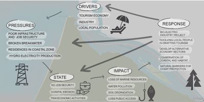
Beach of Narva-Jõesuu has a high potential with high power. Controlled by the government and regulated with water laws. The beach is affected by the natural forces from the sea and river. There is a decaying breakwater that is ruining the beauty and not stopping the pollution from the river. There are external factors like the hydroelectric power plant on Narva river that are highly affecting the water quality. The factory belongs to Russia and is a high power in the area. Tourism is the highest economical powers of Narva-Jõesuu but is still not affecting the area much. Environmentally it is a good thing. | |||
=== Sacred spaces and heritage === | === Sacred spaces and heritage === | ||
Revision as of 12:52, 5 June 2018
>>>back to working groups overview
| Area | 11.03 km2 (4.26 sq mi) | |
| Place | Narva-Jõesuu
| |
| Country | Estonia | |
| Topics | Coastal Line study of Narva-Jõesuu | |
| Author(s) | Anne, Erki & Rajen | |
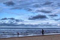
 Narva-Jõesuu beach Narva-Jõesuu beach
| ||
Rationale
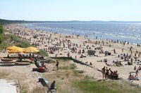
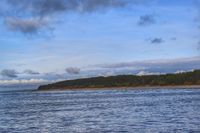
Narva-Jõesuu is a city with the longest sand beach in Estonia. It is located on the border with Russia and also close to Finland, being the closest touristic coast for tourist. Beautiful nature and landscape give the city a high potential but it is also challenging with depopulation and some pollution from the river.
Location and scope
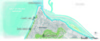
You can edit this map with the map editor
A Landscape System Analysis
A.1 Landscape layers and their system context
Geomorphology, landscape units and coastal typology
- Description of evolution, status quo and driving forces, is the coastal typology changing? Why is that? (approx 200 signs)
Narva-Jõesuu is a town in Ida-Viru County, in northeastern Estonia. It is located on the country's northern Baltic coast and the Gulf of Finland. The town's name in Estonian and Russian means "Mouth of the Narva", the river which forms the border with Russia. Narva-Jõesuu beach, covered with fine sand and lined with a pine forest, is well-known for its unique natural environment and is the longest one in Estonia; running 7.5 km on the south shore of the Gulf of Finland. There is 2.5 km wide foredune plain over the south which consists of fine sandy deposits forming approximately 80 parallel ridges built by wave action and of sinuous irregular ridges formed by a combination of wave and aeolian processes. Likewise, the coastline is been modified by floating peat islands from the river that are washed to the shore by the water currents and wind movements. This phenomenon is caused by the construction of Narva hydroelectric station in 1950, which in order to be built a big swamp was flooded.
-
 Geomorphology of Narva-Jõesuu
 -
 Narva-Joesuu in Summer


Land use
- settlements, infrastructure, agriculture, resource extraction, natural areas, energy production...
The settlement arose around the 14th century, It was the site of an outer harbour of the City of Narva from the 16th century, containing several timber stockyards, sawmills, and a small shipbuilding industry. Narva is a melting pot of Estonian and Russian cultures and a great place to stop and relax when travelling to and from St. Petersburg. The first spa in Narva-Jõesuu was opened in the 19th century, beginning a fine and well established tradition. Once a prime example of Baroque architecture in Europe, the town was heavily damaged in the Second war and almost entirely rebuilt. In the last few years its resort facilities have been renovated and thanks to its eight-kilometre-long white sand beach lined with pine tres, Narva-Jõesuu has become a popular summer destination.
- description of evolution, status quo and driving forces, is the land use likely to change? Why is that? (approx 200 signs)
- add 1-2 graphical representations to the image gallery, you can add more if you like
-
 Land use development
 -
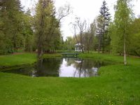 Hele Park also known as "Light Park" with a small pond in the centre
 -
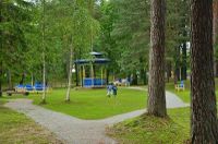 Pime Park also known as "Dark Park"


Green/blue infrastructure
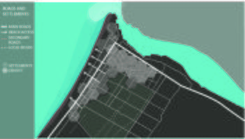
A green infrastructure approach to coastal improvement—a "living shoreline"—can be created using plants, reefs, sand, and natural barriers to reduce erosion and flooding. It also can lessen the associated impacts on human health and property. A strategically planned and managed network of natural lands, working landscapes, and other open spaces that conserve ecosystem values and functions and provides associated benefits to human populations. Green infrastructure preserves “coastal character”. Green infrastructure creates natural buffers for people during hazards events. And also strengthened the connection between people and environment and people and place. A well functioning blue infrastructure requires an integrated approach to create a network that prevents floods, droughts and has a good water quality. Clearwater is important for contribution to an attractive urban environment for physical exercise and mental health effects of the presence of surface water.
Natural infrastructure and combinations of natural and built infrastructure can provide important storm protection and other benefits to coastal communities, thus more research and investment in, and application of, natural and hybrid approaches need to be included in coastal resilience planning and decision-making at all levels.
-
 Map showing green and blue infrastructure
 -
 Pine forest along along the coast
 -
 Narva Bay
.jpg)


Actors and stakeholders
The changes in the landscape are driven by both Estonian and Russian governments. Building on the coastline is regulated with spatial planning. The breakwater near the river mouth is collapsing and should be rebuilt. Also, the Russian hydroelectric station on the river is causing pollution and the ineffective breakwater is failing to keep it away from the beach. Sandy coast and beautiful nature support tourism development, which attracts stakeholders and businesses. There are currently many businesses gone bankrupt and the city is struggling with emigration.
-
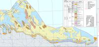
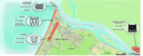 Power Map

Beach of Narva-Jõesuu has a high potential with high power. Controlled by the government and regulated with water laws. The beach is affected by the natural forces from the sea and river. There is a decaying breakwater that is ruining the beauty and not stopping the pollution from the river. There are external factors like the hydroelectric power plant on Narva river that are highly affecting the water quality. The factory belongs to Russia and is a high power in the area. Tourism is the highest economical powers of Narva-Jõesuu but is still not affecting the area much. Environmentally it is a good thing.
Sacred spaces and heritage
Sacred spaces and heritage are places holding religious or spiritual importance to followers of those religions and practices. In Coastal areas like Narva-Jõesuu, which is the border between two nations and where heritage is viewed as a keeper of biological diversity and sources of information about the activities of our ancestors. It has a cultural value from the 19th century which is rich in seafaring related heritage; sheds for nets and boats, lighthouse, rescue stations, and military defense structures. These places are of historical importance in both nation’s political and social context. Russian and Estonian natives consider these coastal heritages to be an integral part of their identity. Also, they provide unique features for tourism of those coastal areas, tourist can feel that they are traveling back in time and truly immerse in the local experience by visiting this coastal heritage. They give authenticity and uniqueness to the place and with the rise of the internet and global-nomadic lifestyle of the young generation, they are keen to visit lighthouses, historical harbors, resorts, world heritage sites, local urban and rural architecture as well as archaeological sites.
Some of the sacred spaces around the Narva-Jõesuu: 1) Church of the Kazan Icon of the Mother of God- The distinguished wooden church has been constructed in 1893 in Meriküla. It was placed to its present location after it was completely destroyed in World War II. 2) The memorial stone of the landing troops of Meriküla - This was the place where the Soviet landing troops of more than 500 men landed on February 14, 1944. The landing troops were caught by the Nazi fire and most men were killed. So, to honor and respect those troops, the memorial stone was built. 3) Pine of Meriküla - Meriküla pine is a nature conservation native tree in Ida-Viru county, Narva-Jõesuu. The pine is a multifloral tree that is an unusual shrub-like owl. The painter Ivan Šiškin, who was resting between Narva-Jõesuu and Udri, loved to sit and paint under this tree.
-
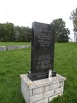 The memorial stone of the landing troops of Meriküla
 -
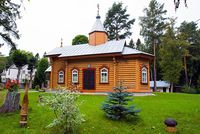 Church of the Kazan Icon of the Mother of God
 -
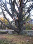 Pine of Meriküla


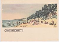
Visual appearance and landscape narrative
Essential elements of the landscape character are the fine sand covered beach lined with pine forest, river mouth, and the sea. The landscapes in Narva-Jõesuu have not been painted very much but there are a few paintings and postcards exhibiting the sandy beach, sea and pine forests. On the city border grows a big pine tree with spreading branches under which famous Russian painter Ivan Šiškin loved to sit and paint. Šiškin has a few paintings of the pine and the surroundings exhibited in Saint Petersburg’s museum. There is a legend about Meriküla pine that couples who kiss under it will stay together forever.
-
 Pine forest along the coast
 -
 Postcard from 1960.
 -
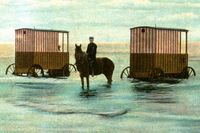 Bathing machines at the beginning of 20th century


A.2 Summary of your landscape system analysis and your development Targets
- You can summarize your findings with an DPSI(R) Model or a Spider Diagram
- Link back to the Sustainable Development Goals: Which goals are at risk?
- What is your hypothesis for this landscape?
- Visualise your hypothesis with one graphic/pict
- Are there any existing initiatives taking action in this landscape? Do you have a critical perspective on that?
- Add text and visuals
It was a major focal trade point and tourism hub in 1900s , people used to go there for summer vacation. Main problem here is the emigration and pollution from the old hydroelectric power house. Actors responsible for this city’s preservation and restoration are Estonian and Russian government, should firstly make an effort to control pollution in the river. Spatial planning should be done such that the infrastructure are planned without hampering the coastal area and the green/blue infrastructure. They should try to highlight the coastal areas for tourism by collaborating green and blue infrastructure, even adventure activities like parasailing, jet-ski or jungle hiking trails could be a pulling factor for tourists. As this area also carries a lot of history with itself, the pre-war lighthouses and other sacred spaces , if government could find a way to incorporate these historical sites to museums or even a memorial place for the war victims, and build the landscape around such sites to incorporate with the green/blue infrastructure, tourism can flourish. Aesthetically pleasing sites along with historical importance have been proven to be major tourist attraction. Our hypothesis for the landscape of coastal areas are based on the better collaboration of its natural landscape and entwining of heritages with the landscape. This coastal area has been pictured as a summer destination. If local people and local government work towards preserving the landscape and making infrastructures for tourism, then, this place could be bustling with people, trade and energy all year long
-
 Spider diagram

-
explain your hypthesis briefly in the caption
A.3 Theory reflection
- Reflect on at least three international policy documents in relation to their local landscape case
- choose one international, one European and one national document
- You can choose references from our reading list
- Scope: 250 words
PolyMETREXplus RINA Gulf of Finland Spatial Vision (https://www.hel.fi/hel2/ksv/julkaisut/polymetrex/gulf_of_finland.pdf) ■to exchange practical knowledge and experiences of spatial planning between the Gulf of Finland city regions ■ to cooperate with the city-regions in the Gulf of Finland with the aim to create spatially, polycentric regions in the future ■ to identify the key challenges and opportunities for the triangle of city-regions and translate these into policy options ■ to develop a spatial vision for the Gulf of Finland and prepare a joint statement action plan.
A.4 References
- give a full list of the references you have used for this section
http://entsyklopeedia.ee/artikkel/narva-j%C3%B5esuu3 http://forte.delfi.ee/news/juskegaavastamas/jaak-juskega-kadunud-eestit-avastamas-koige-kaunima-rannaga-kodumaise-kuurordi-ehk-naljalinna-lugu?id=77744456 https://dea.digar.ee/cgi-bin/dea?a=d&d=narvajoesuu20130701.2.4 https://et.wikipedia.org/wiki/Merik%C3%BCla_m%C3%A4nd
Phase B: Landscape Evaluation and Assessment
B.1 Assessment Strategy
Based on the Landscape System Analysis of Narva-Jõesuu, insufficient information about this place as a holiday destination, breakwater near the river mouth, pollution from the hydroelectricity project near the border, lack of financial and human resources, abandoned houses and factories, poor connection with border nations, transport connection including the public transport is inadequate, unmanaged coastal area on all around are the main problems around Narva-Jõesuu which is hampering to flourish tourism and development of this area.
Referring to this problems, we manage to consider some goals;
- Preserve the cultural heritage along with the landscape around it
- Making a good relationship between both the border nations and making it a suitable holiday destination as it used to be before world war II
- For the economic, reopening the fish factory allowing local people as a employee and addition of more beach activities near the coast line to attract and give wide varieties of activities for visitors.
- Adding more walking trails, boardwalks and establishing camping site for overnight stay in the pine forest could be the best use of the forest available near the coastal area.
- providing a system that enables linking the quality of the environment to its management
As this place have very old history, preserving this cultural heritage along with the landscape around it is the main strategy of our assessment. Also this area is famous for summer vacation, by adding some adventurous activities and some activities around the big pine forests we can create a beautiful nature vacation targeting all types of tourist. For achieving this goals we manage to make three different study one of them is SWOT which ... Another one is ecosystem services which will contribute to the ecosystem structure and human-well being. And the last one is Blue Health Environmental Assessment(BEAT) method which helps us to find the impacts on population and on landscape health.
B.2 Mapping
- As defined by your assessment strategy you conduct the mapping and present your findings here
- As a minimum, at least three different themes need to be mapped, you may choose more if needed
-
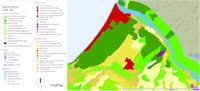
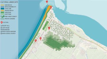 Cultural Landscape Map On this map there are different natural character areas which make the place unique and give it character. There are also recreational areas like parks and beach. Location points with numbers are showing different cultural elements like the lighthouse, resort hall, museum, Orthodox Russian church, breakwater which are representative of the place or what locals and tourists can relate the history to.
 -
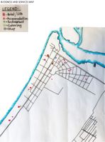
 Roads and Settlement Map. This map shows all the roads connection in the town as well as road connection to the beach and the settlements around the Narva-Joesuu Town. Town holds 2,600 inhabitants, most of them are Russian speaking aging people. In this map we divided the settlement into two area, one with brown color shows the houses where people are still living and surrounding environment is maintained well whereas settlement with black color shows the abandoned houses. But somehow people are still using the garden of this abandoned area for crops and vegetables. There is a main road with red color which connects directly to another big city Narva and different secondary roads are connected with it around the town which we can see in the orange color. Some of the roads are directly connected to the beachside where some parking is also available and some roads are only used as a pedestrian that leads to the beach.
 -
 Business and Services Map The purpose of this map is to help analyze where business and services are concentrated in Narva-Jõesuu. It shows where the different hotels, smaller accommodations businesses, SPAs, restaurants, cafes, and grocery shops are located. It became clear that the area next to the beach is most favorable in both Hotels, SPAs, and restaurants while grocery shops were more in the center. Smaller businesses are located all around the town. This information shows the preferences and hotspots of the businesses plus helps to take into consideration the possible new touristic areas.


B.3 Problem definition and priority setting
Problems:
Being the best holiday destination during 19th century, it’s lacking its importance and value these days. Information about this destination is insufficient, even Estonian people are unknown about this place. Lack of financial and Human Resources is the major drawbacks which is constantly pulling back this place from development. Pollution from the river and pollution from the hydropower is degrading the water quality of the river, which is the major reason to stop the fish factories to run ahead. These place also lacks proper transport connection. And the people living here speaks mostly Russian and informations provided are also not available in multiple languages it’s hard for tourist or visitors to communicate.
Priorities setting:
The main priority is creating and developing strong destinations for visitors. Trying to bring back the identity and feeling from the 19th century by preserving its cultural heritage or somehow restoring them in other way like by building museum. Creating the missing infrastructure like proper transport facility which directly connects Tallinn to Narva-Joesuu or from St. Petersburg, educate entrepreneurs and involve local community. Developing water tourism like small ports and harbors, swimming, developing beachside tourism infrastructure. Developing or renovating different theme park in more broader way. Adding more walking trails, boardwalks and establishing camping site for overnight stay in the pine forest could be the best use of the forest available near the coastal area.
-
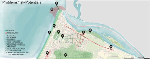 Risk and Potential Map

B.4 Theory reflection
- Assessment Methods
1) Ecosystem Services
Ecosystem services are the contributions of ecosystem structure and functions to human well-being. This implies that mankind is strongly dependent on well-functioning ecosystem and natural capital that are the basis for a constant flow of ecosystem services from nature to the society. Coastal ecosystem of Narva-Joesuu such as huge pine forests, gardens, parks, Narva river, provide a number of supporting and cultural ecosystem services to both the local communities as well as the wider population who benefit from them.
i) Narva River - fishing, hydropower production (provision) - border between two nations, mouth of Narva (value) - pollution from the hydropower, abounded fish factories, pollution (problems)
ii) Beach: - summer destination, recreation (provision) - longest sand beach in Estonia, Historical Background (value)
- whole 7km sand beach is not used properly and not well maintained (problems)
iii) Pine Forest - trails and boardwalk, collecting berries and mushroom, wood used for construction (provision) - whole the coastal area is covered by pine forest (value) - not managed properly (problem)
iv) Parks and garden - food from garden, intrinsic environmental, aesthetic, and recreation benefits (value) - parks shows the meaning of light and dark and garden shows the traditional way of cultivation (value) - parks are small and provides limited services for children (problems)
2) SWOT Analysis
Strenghts
- Location near the beach and river, border of EU and Russia
- Excisting SPA's and vacation elements
- Natural resources
- Longest sand beach in Estonia
- Rich history and heritage
Weaknesses
- Peripheral location in the country
- Economic situation
- Poor infrastructure
- Seasonality
- Abandoned and broken buildings
- Poor image and reputation
- Language problems
- Emigration
- Aging population
Opportunities
- Economic growth
- Developing to a vacation destination
- Potential for sailing and fishing
- Continuous protection of and use of nature and living environment
- Business opportunities between EU and Russia
- Economic cooperation
Threats
- Continuing economic problems
- Decreasing tourism
- Continuing emigration
- Threat from Russia
- environmental degradation
3) Blue Health Environmental Assessment (BEAT)
B.5 References
- give a full list of the references you have used for this section
Phase C – Strategy and Master Plan
C.1 Goal Setting
- Define strategic planning objectives based on the evaluation findings
- Link back to your original targets from section one and the Development Goals
- 150 words text contribution
C.2 Spatial Strategy and Transect
- translate your strategic goals into a vision
- develop a spatial translation of your vision
- exemplify your vision in the form of a transect with concrete interventions
- add map(s) and visualizations
-
add caption here
-
add caption here
-
add caption here
-
add caption here
C.3 From Theory of Change to Implementation
- For implementing your vision: Which partnerships are needed? Which governance model is required?
- Who needs to act and how? Draw and explain a change/process model/timeline
- Which resources are needed? On which assets can you build?
- add 150 words text and visuals
-
add caption here
-
add caption here
C.4 References
- give a full list of the references you have used for this section
D. Process Reflection
- Reflect in your intercultural and interdisciplinary team on the outcomes of your study
- Which limitations were you facing?
- What have you learnt from each other?
- What would you do differently next time?
- You can also use diagrams/visuals
- 250 words text