Caspian Sea Nur Beach: Difference between revisions
| Line 182: | Line 182: | ||
<gallery caption=" " widths="500px" heights="200px" perrow="1"> | <gallery caption=" " widths="500px" heights="200px" perrow="1"> | ||
File: | File:Partnerships and governance Fardokht and Yasaman.jpg|''In the purpose of achieving to the named goals, a cooperation among the Government, Local Government, Builders, Professionalist, Citizens and users would be needed. We do consider the citizens strongly because in the end they are the ones who will use this place. Therefore the results will be more functional and proper if from the beginning the participation of citizens occurs. Also having a realistic process from the first step till the end with the consideration of proper connection among different partnerships would be needed.'' | ||
File: | File:Partnerships and governance Fardokht and Yasaman (2).jpg|''add caption here'' | ||
</gallery> | </gallery> | ||
Revision as of 07:57, 15 June 2018
>>>back to working groups overview
| Area | Caspian Sea, North of Iran | |
| Place | Nur Caunty | |
| Country | Iran | |
| Topics | Nur Beach | |
| Author(s) | Yasaman Rahimi, Fardokht Hadji Salimi | |

| ||
Rationale
- Why do you think this case is relevant? What is your hypothesis considering the landscape challenges?
- Format: 3-4 sentences
Location and scope
You can edit this map with the map editor
A Landscape System Analysis
A.1 Landscape layers and their system context
Geomorphology, landscape units and coastal typology
-
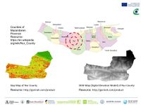
 In Nur the Green & Blue are besides. Nur County by having beautiful parts of Caspian sea is one of the most important tourism regions in Iran and the touristic development of this city has been considered in the plannings of the government. Our hypothesis: Potential to be one of the largest coland tourism poles of Iran
 -
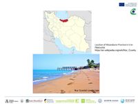
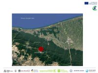
 The Nur beach is located on the north of Tehran, in the Mazandaran province, phasing parts of the Caspian sea and is beside of Nowshahr, Amol and Mahmudabad provinces


Land use
-
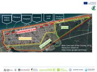 As it has been shown on this map, the main land uses are divided into four main region of Nur Forest, Residential, Agricultural and also the commercial line on the north of the city. Also the important places have been shown on the map.
 -
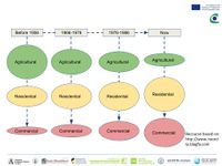 Development Process,On this diagram has been shown that how the agricultural land sue decreased over the years and instead commercial and residential land uses increased (There is low accessibility to data from 1986 until now via internet network).


Green/blue infrastructure
-
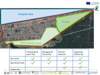 There are three main Green and Blue Infrastructure in Nur which are compared based on their influences, in the following table.

Actors and stakeholders
-
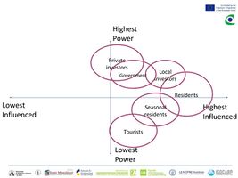 It can be said a big part of the changes in this region is caused by new constructions.Here are the explanations about some of the named groups in the following Power Map:_Private Investors: Those who invest but do not leave in Nur_Local Investors: Those who invest and leave in Nur._Seasonal Residents: Those who have a house in Nur, but they leave in other cities in most of the seasons_Tourists: Those who do not have a house in Nur and come to visit this city.

Sacred spaces and heritage
-
 Nur forest park is the biggest natural park in midlist by 3600 ha. It holds a symbolic meaning in the area because of its location and Monumental trees.
 -
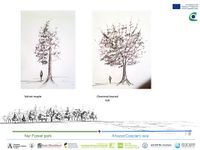 Nur forest park is located near the sea; hence arrangement of sea and forest or green and blue infrastructure together, brings a symbolic identity and sense of place there.In addition to this, there are monumental trees like Velvet maple and Chestnut-leaved oak.


Visual appearance and landscape narrative
-
 A huge rock due to the erosion,shaped like an elephant.There is a religious myth among the local people implying that, this rocky elephant is a miracle!
 -
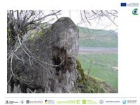 Resource: http://tripbama.com/fa/ Access : 18.04.2018


A.2 Summary of you landscape system analysis and your development Targets
-
 explain your analysis briefly in the caption

-
 If the current situation goes on, more and more agricultural lands will be changed to commercial and residential buildings and based on low functional management, results such as air pollution, water pollution, low diversity and decrease of health of the society would occur.BUT by having a multi aspect planning and a functional management system, considering precious natural resources and future generation, Nur can become one of the great tourism poles of Iran.

A.3 Theory reflection
* Building a green infrastructure for Europe Different environmental features which function in different scales, can be considered as GI. Although not any green area can be included, it needs to act in a more multifunctional way such as a cool air corridor or an encouraging place for biodiversity. Spatial planning is one of the effective ways to build GI, including strategic levels of locate the best places (for habitat enhancement projects), guide infrastructure developments towards robust areas and also identify multi functional zones. The benefits would appear in different aspects such as environmental, social, climate change adaptation and biodiversity.
* Sustainable Development Goals
On 2015, 17 main goals were set focusing on end of poverty, protect the planet and ensure prosperity for all. As examples of these goals good health and well-being (considering aspects such as clean water and sanitation, reducing malaria and the spread of HIV/AIDS), affordable and clean energy (considering aspects such as renewable sources, modern energy and efficiency) and sustainable cities and communities (considering aspects such as transportation, housing, energy and infrastructure) can be mentioned. For achieving these goals -in the next 15 years- the cooperation among governments, private sector, civil society and people would be needed.
* European Commission Marine Strategy Framework Directive
Marine and coastal environments is experienced the effect of pollution from land and ocean sources. Hence for preserving the marine and coastal zone, the marine directive framework as a first EU legislation was established which is promoting a sustainable use of marine waters. Good environmental status (GES) of Europe’s waters by 2020 is the major goal of the marine directive framework. While besides maintaining the water, economic and social sector related to marine zone are plays and important role. The directive sets up European marine regions and sub regions based on geographical and environmental criteria and it lists four marine regions; The Baltic sea, the North-East Atlantic Ocean, the Mediterranean Sea and the Black sea. Each member state needs to devise a strategy for its marine water and it should be kept up to dated and reviewed every 6 years. Now, the second cycle of the process is started in 2018.
A.4 References
- Directorate-General for Environment (European Commission) (2014), Building a green infrastructure for Europe, European Union, Belgium
- European Commission Marine Strategy Framework Directive
- United Nations. Sustainable Development Goals (SDGs)
Phase B: Landscape Evaluation and Assessment
B.1 Assessment Strategy
- Based on the hypothesis derived from your previous landscape systems analysis you are now asked to define the goals for assessing the landscape. Your assessment is the basis for evaluating the landscape status.
- Which elements and phenomena need to be mapped, why and how?
- This a text contribution, max 250 words
B.2 Mapping
-
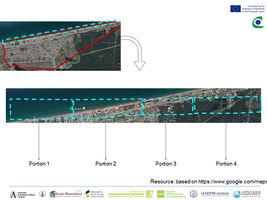 With the purpose of more detailed theme maps, the plan of Nur Beach has been divided into four portions.
 -
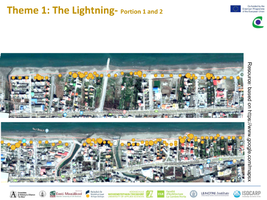 In the following map, by the density of the yellow duts, the quality of the current lightning has been shown. Although in front of the residential constructions there are lightnings, but there are lots of places beside of the sea without proper light during the night.
 -
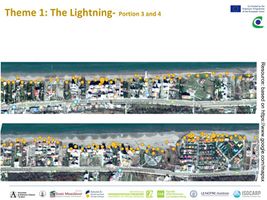 As it gets closer to the east part of Nur County, the number of the planned and designed areas with propet lightning on the edges, increase.
 -
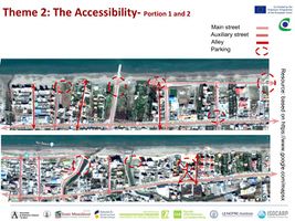 There are many street connections, in different widens which connect the main east-west street to the beach, although most of these streets are not equipped by proper pedestrian paths.
 -
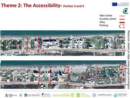 The end of most networks connections-between the free space of the street and the beach- have been used by people as parking areas.
 -
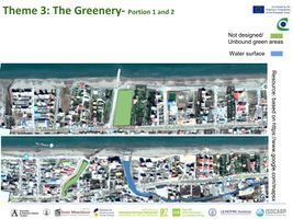 On these maps the current green areas have been shown. Also the water surface as an area with potential has been colored. There are also lots of green areas in the private territories which are usually surrounded by the territory walls.
 -
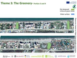 Perhaps it could be said the function of being a green space, have been defined for many of these areas, but not all of them have been designed, which as a result some of them -specially the unbounded areas- can be considered as risks of having low maintenance and low safety.


B.3 Problem definition and priority setting
- In this level, three different layers of each portion have been overlapped. Therefore it can be seen the places which have lacks and problems (in the three themes of Lightning, Accessibility and Greenery). The places which have the boldest potentials, demonstrated by having multiple layers on them.
-
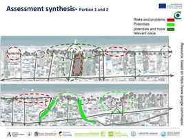 In fact those areas with higher number of ‘green lines’, have the highest potential and areas higher number of ‘red lines’, have the highest risk.
 -
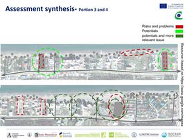 The lack of proper lightning can result the risk of lack of safety and also low quality of the space, which such situation is happening between of some of the residential areas. Also having the parking lots in the open spaces between the end of the streets can reduce the quality of the open space as well.
 -
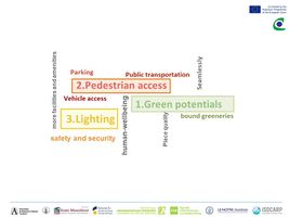 Locating main poles in Nur Beach, finding comprehensive solutions to supply the lacks, strength the potentials such as designing and make a proper plan for abounded green area, defining parking areas based on the location of the poles and streets connections, providing bicycle and pedestrian access to Nur Beach and , providing proper lightning are our major priorities.


B.4 Theory reflection
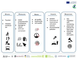
- Being far from our project site although motivated us to moslty go through online researches and also relying on long distance talks with the people whom have used this place (friends, family members and etc.) but it also caused us to have access to limited data. Based on the kind of the data that we could have access to and also proper needed analysis for this site, we chose a combination of DPSIR analysis and quantitative and comparative assessments to achieve a wide perspective through drivers, pressures, states, impacts and responses to be able to consider different aspects in our further process and to find the lacks and potentials by overlaping different layers
- During this phase, the lack of accessible and updated online resource and also although by having long distance connections to the people whom have experienced this site, we achieved important information, but still in our case not being able to go to the site in person to have deep aimed interviews with the citizens and users could be considered as an another limitation.
B.5 References
- M.Sheibani, N.Razavi, F.Mofrad (2017). Coastal Landscape Characterization (The Case of the Sartol Seacoast), RI-VISTA, Bushehr, Iran.
- P.Kristensen (2004). The DPSIR Framework, National Environmental Research Institute, Denmark.
- N.Aladin, I.Plotnikov (2004). The Caspian Sea, Lake Basin Management Initiative
- Svarstad, H., et al. (2007). Discursive biases of the environmental research framework DPSIR, Land Use Policy, doi:10.1016/j.landusepol.2007.03.005
Phase C – Strategy and Master Plan
C.1 Goal Setting
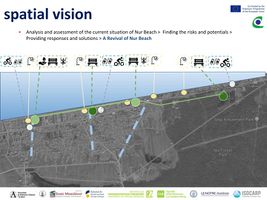
- Based on the results of overlapping three different layers of lightening, accessibility and also greenery, with the consideration of the users, their needs and their wants, in this level we know the points of our site with the highest risk mounts and also highest potential. Finding solutions and responses considering these three different aspects in the aim of providing proper poles on the site of Beach Nur in the same way of reducing the risks and using the current potentials would be considered as our main objectives through strategic planning.
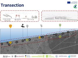
C.2 Spatial Strategy and Transect
- translate your strategic goals into a vision
- develop a spatial translation of your vision
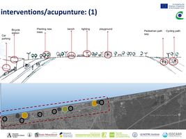
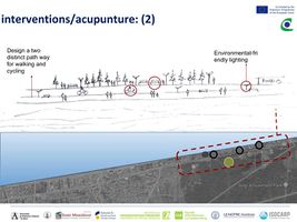
- exemplify your vision in the form of a transect with concrete interventions
- add map(s) and visualizations
-
 add caption here
 -
 add caption here
 -
 add caption here
 -
 add caption here


.jpg)

C.3 From Theory of Change to Implementation
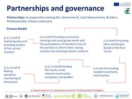
- For implementing your vision: Which partnerships are needed? Which governance model is required?
- Who needs to act and how? Draw and explain a change/process model/timeline
- Which resources are needed? On which assets can you build?
- In the purpose of achieving to the named goals, a cooperation among the Government, Local Government, Builders, Professionalist, Citizens and users would be needed. We do consider the citizens strongly because in the end they are the ones who will use this place. Therefore the results will be more functional and proper if from the beginning the participation of citizens occurs. Also having a realistic process from the first step till the end with the consideration of proper connection among different partnerships would be needed.
-
 In the purpose of achieving to the named goals, a cooperation among the Government, Local Government, Builders, Professionalist, Citizens and users would be needed. We do consider the citizens strongly because in the end they are the ones who will use this place. Therefore the results will be more functional and proper if from the beginning the participation of citizens occurs. Also having a realistic process from the first step till the end with the consideration of proper connection among different partnerships would be needed.
 -
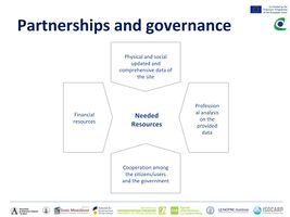 add caption here

.jpg)
C.4 References
- give a full list of the references you have used for this section
D. Process Reflection
- Reflect in your intercultural and interdisciplinary team on the outcomes of your study
- Which limitations were you facing?
- What have you learnt from each other?
- What would you do differently next time?
- You can also use diagrams/visuals
- In the process of this project there were different limitations, especially in the access to the needed data and also not having access to have fieldwork in the site with the citizens and local government, which in some steps it made it hard to go further. But we learned and tried to make the best profit from what we had access to. It helped us to have a wider point of view, to think in a more creative way, to either find a way or create a way through our goals.