Averno and Lucrino Lakes-Pozzuoli Coast: Difference between revisions
| Line 244: | Line 244: | ||
<gallery caption=" " widths="500px" heights="200px" perrow="1"> | <gallery caption=" " widths="500px" heights="200px" perrow="1"> | ||
File: | File:STK2.jpg| According to the goals set at the beginning of the project we have developed our own in order to improve the quality of the place and the life of its inhabitants and visitors. Our area was initially a large industria, so it was absolutely necessary to restore and reclaim the brownfield areas, but also to allow the industry to regrow cleanly. As support for these new activities, infrastructures must be upgraded to ensure the flow from neighboring municipalities, reduce traffic and pollution and develop the interest of private investor in commercial activities and tourism attractors. A new clean network would allow the whole area to be more accessible and to let citizens and foreigners enjoy the beauty of this place rich in history and nature. At the moment this area has a high potential that is not exploited at best, but thanks to the maintenance and protection of the natural parks and marine environments, we hope it will return to the splendor of the past. For all these reasons with our project we hope to fulfill the prefixed objectives 7, 9, 11, 14 and 15 of the sustainable development.'' | ||
File:Goals2.jpeg| The development of the project must start with an increasing interest, at first public and then private in the area. Depending on the needs expressed by all the actors who take part in his life such as citizens, municipalities, users, investors and public authorities, a draft of a plan should be presented and evaluated, discussed again ad finally putted in place. It is very important for the maintenance of the progress that will be acquired over time to take into account of the satisfaction of the needs of those who work and live the activities and the places. Especially in a reality like the Neapolitan one where public space is not very respected and is vulnerable to rapid degradation. | File:Goals2.jpeg| The development of the project must start with an increasing interest, at first public and then private in the area. Depending on the needs expressed by all the actors who take part in his life such as citizens, municipalities, users, investors and public authorities, a draft of a plan should be presented and evaluated, discussed again ad finally putted in place. It is very important for the maintenance of the progress that will be acquired over time to take into account of the satisfaction of the needs of those who work and live the activities and the places. Especially in a reality like the Neapolitan one where public space is not very respected and is vulnerable to rapid degradation. | ||
Latest revision as of 12:07, 15 June 2018
>>>back to working groups overview
| Area | Averno and Lucrino Lakes | |
| Place | Pozzuoli, Naples | |
| Country | Italy | |
| Topics | Heritage, Turism & Landscape in Pozzuoli Coast | |
| Author(s) | Vassallo Martina © - Errichiello Raffaele - Iossa Pasquale - Marandino Federica | |

| ||
Rationale
Pozzuoli is one of the most relevant site in Naples metropolitan area. The Coast is rich of assets of cultural interest, starting from the old Roman military port nearby Averno and Lucrino Lakes (full of monuments, temples and archeological sites), continuing to Monte Nuovo and Astroni Park (where is located the famous Solfatara), till the new area recently built and still in requalification phase of Rione Terra. This quarter extended to the dock of Puteoli (ancient name of Pozzuoli) is developing as a new economic and touristic source; this changes are reflected in other parts of the city like industries and beaches increasingly crowded. Our priority is to include the coastal landscape into a urban resilience that provide green and blu infrastructure.
Location and scope
You can edit this map with the map editor
A Landscape System Analysis
A.1 Landscape layers and their system context
Geomorphology, landscape units and coastal typology
Pozzuoli is located on the homonymous gulf in a volcanic area, the Campi Flegrei, which includes a still active volcano, the Solfatara. The territory is mostly hilly, including several volcanic craters the Astroni, Monte Nuovo and the one that houses Lake Averno. From this area the ground falls quite steeply thru the sea. Typical of this city and the entire area of the Campi Flegrei is the geothermal phenomena called bradyseism, which is the raising and lowering of the earth's crust as a result of the increase in underground pressure. The rapid rise in sea level generated by this phemomena involved the coastal area and the port, which was repositioned about 50 meters after than the previous location.
-
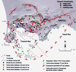 Analysis weathering from INGV Vesuvian Observatory
 -
 Progress of the coast after bradyseism phenomenon in 1980
 -
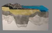 Study of subsoil, photo from Science Magazine, 7th August 2015
 -
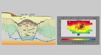 Study of subsoil, photo from Science Magazine, 7th August 2015


Land use
Pozzuoli, at the time named Dicearchia, was inhabited since 531 a.C. as greek colony under dependency of Cuma. In 338 a.C. all the Campania region was occupied by Romans, who gave to their key maritime colony the new latin name Puteoli which means small wells, due to the numerous springs of thermo-mineral waters found there. Since the first settlements the population increased and Pozzuoli became the point of convergence of rural, urban and industrial areas. In the city there was a flourishing industrial activity developed along the road Via Fasano that connects the center with the urban settlement of Arco Felice. The first industry was the British Armstrong. Between the two World Wars Pozzuoli was one of the most important industrial pole for the armament of battleships. During 1957 the industry has been trasformed into mechanical enstablishment “Aerfer” and after 10 years incorporated by railways workshops “Sofer” (one year later, in 1968 becamed consortium “Inbus”). In 2003 the factories were closed after 100 years of activity. Now there’s a project of redevelopment for a sailing center. Olivetti enstablishment was built in 1955 by Luigi Cosenza. The singularity of the building is an exemplary integration in the natural panorama of the Neapolitan coast and the nearby residential district form a unique space in the area. The Law 64/1986 allowed a restructuring plan for the Olivetti Research Centre, now the enstablishment has a new role with new laboratories for new office’s activities. The industrial area is going to be redeveloped through the improvement of roads and sea trasports, at the moment the influx of people is focused on maritimes link to the islands and on the fishmarket that is growing faster (is the 3th one more important in Italy). Lucrino Lake take is name from latin word "Lucrum" (that means earning, profit) because of the fish farms and oysters (senator Sergio Orata became one of the richest man in that age). The city remains in contact with Napoli and the suburban aereas nearby trought 3 reailways, one subway and the Cumana and Circuflegrea lines.
-
 Land use
 -
 Public transport
 -
 Land areas
 -
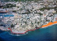
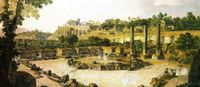
 View of Pozzuoli dock


Green/blue infrastructure
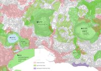
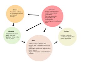
Blue and green infrastructures in the study area represent a potential resource for the development of sustainable economies and tourism, due to the strong presence of these in the territory. The Natura 2000 network, in fact, provides the enhancement and protection of green spaces, as a habitat of flora and fauna characteristic of the Phlegrean territory, but also because they represent green lungs in an area with a high rate of urbanization, which in many cases leads in to illegal construction. The Mount Gauro, the Solfatara, the Monte Nuovo, the crater of the Astroni, the underwater archaeological reserve of Baia and the Lucrino coast define the areas of the green infrastructures, which represent a uniqueness in the landscape and a place that increases the healthiness of citizens, according to the PUC of Pozzuoli of 2016. Instead the blue infrastructures are represented by the lakes of Averno and Lucrino and the coasts of Pozzuoli and Lucrino, where bathing is not permitted in all points of the coast due to pollution of the sea. The restitution of the Phlegrean coast to the citizens and the protection of marine biodiversity, would lead a strong increase in tourism and economic activities, as well as a greater awareness of the users.
-
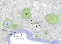 Analysis infrustracture
 -
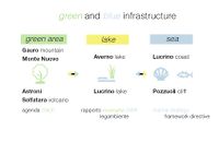 Diagram infrastructure


Actors and stakeholders
The Municipality of Pozzuoli is the administrator of the study area, instead the adjacent territories are under the Municipalities of Bacoli, Monte di Procida or Napoli. Everyone has developed a municipal urbanistic plan (PUC) in order to analyse the actual condition of the region and planning new functionalities and connections, the safeguarding of biodiversity and the enhancement of historical and natural heritage. A Territorial Landscape Plan (PTP) ” Piano Paesistico Territoriale dei Campi Flegrei “ with the aim of restoring the landscape and promoting better enjoyment for the Campi Flegrei area has been developed also by the Superintendence for Cultural Heritage and Environmental assets. As regards the physical aspects of the coast, the Basin Authority are drawing a plan to indentify and protect the seashore areas affected by coastal erosion. Since the advancement of this area has started also inhabitants, business owner and foreign investors are cooperating to distinguish, heal and improve the city.
-
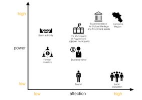 Power Map

Sacred spaces and heritage
- CHURCH
In the city there are a lot of church and cathedral, the most important are the Dome [1] (Cathedral of S. Procolo, recently redevelopted) , Sanctuary of Saint Gennaro [2] (where he was beheaded for martyrdom) and Church of S. Maria delle Grazie [3] (the oldest parish).
- MONUMENT
War Monument and Anarchist Monument [4,5] .
- ARCHEOLOGICAL SITES
Is one of the few cities in the world that has 2 romans amphitheatres: Amphitheater Flavius [6] and minor . Augustus Temple where on the foundation were built the Dome ; Pozzuoli's Macellum [7], also called Serapide's temple because of a misunderstanding due to egyptian god's statue, symbolized the a precise metric index for measure bradyseism ; the biggest necropolis in the world (after Rome) [8] ; Antonino Pium stadium [9] ; Apollo's temple [10] on Averno Lake ; spa stoves of Nerone [11] on Lucrino Lake; Solfatara [12] ; Astroni crater [13] .
-
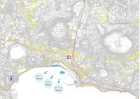
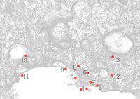 Map of sacred and heritage spaces
 -
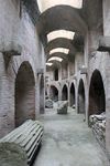
 Serapide Macellum
 -
 Pozzuoli's dome
 -
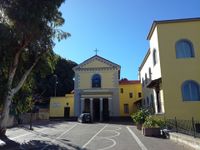 S. Gennaro church
 -
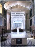
 Underground Pozzuoli


Visual appearance and landscape narrative
Puteoli’s port was the biggest and oldest dock during the Romans age before the construction of Ostia’s port. Solfatara make even more unique this place because of the underground process. Monte Nuovo emerged only in 1538 after an eruption and Lucrino lake became smaller during a bradyseism phenomenon. Rione Terra is the only part of Pozzuoli that has all the stratifications from greek period till now. Legends and miths are settled in this lands since Greeks and Romans and then, in XVIII century where the Grand Tour spread all over Europe many artists such as Gaspar Van Wittel, Pietro Fabris and Jakob Philip Hackert painted the magical athmosphere of Pozzuoli, Napoli and Baia. This vulcanic land has inspired also well known poets from Omer, Strabo, Orazio, Vergilius and Peter the apostle to Petrarca and Boccaccio till Goethe, Madame De Stael, Alexandre Dumas and Marquis De Sade. In spite of all this famous people most of the painting, lyrics and epic are written by ignotus because, in time with no postcard or camera, every visitor wanted to bring back home some handmade memories of the Neapolitan Landscape and population.
-
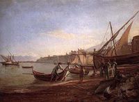 Carelli - Puteoli's port
 -
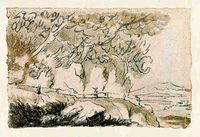 Goethe, Die Solfatara von Pozzuoli, 1787
 -
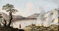 Solfatara, 1707
 -
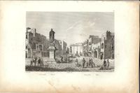 Pozzuoli's square, 1834
.jpg)


A.2 Summary of you landscape system analysis and your development Targets
At the moment analysing the goals of Agenda 2030 we could speak about goal 7 to ensure affordable and clean energy, we could invest in renewable energy resources to save evergy power. Is really at risk the goal 9 because the city is not well connected everywhere by public transport, we have to increase water transport to the islands and urgs a redevelopment of industrial area to make city productive again with a sustainable innovation and industrialization; that take us directly to goal 11 because to make productive and sustainable we need tourism. To attract tourists to visit the area we need to clean the waters, protecting the natural heritage and saveguarding the culture of the place implementing - as example - fishmarkets [that take us to the resiliency] . Fortunally there are no more military industries that can help the climate changes in goal 13, but still remain a problem because there's no a real action to stop it. Indeed the waters are dirty, there's a lot of pollution and criminalities help to destroy biodiversity and all the cultural heritage in which Pozzuoli is famous from century. They reverse a lot of garbage in the sea, so another big problem is the goal 14 unit to goal 15 because of hypothetical arson. Our hypothesis for the place are to redevelop and reuse the archeological industry, increase cyclo-pedestrian path coastwise connected to the improvement of public transports in the whole area, reclaim marine waters for bathing and natural areas for blue and green infrastructure for a touristic growth, extention of the port and fix the coastal erosion.
-
 explain your analysis briefly in the caption

-
 Hypthesis

A.3 Theory reflection
According to Agenda 2030 there are a lot of possibilities on Pozzuoli’s area, with Goal 9 we choose to invest in resilient infrastructure promoting sustainable industrialization and innovative technologies for development. By 2030 we hope to raise industry’s sector, fishmarket and tourism focusing on affordable access for all. The Goal 11 take care of protection and safeguard of natural heritage and world’s cultural. We want to provide public transport, safe roads, green and public spaces for every range of people (from children to disable). Suppurt the resilient buildings with local materials and improve the sea financial (port, market, restaurant, artisanal fishers) for tourism according to regional development planning. Last but non least, the Goal 14 is crucial for the sea’s environment and marine resources. Water, weather, climate, coastlines are important for a growth of a city that face to the sea. By 2020 regulate the overfishing and illegal fishing practices [Averno Lake was confiscated by police in 2010 because of mafia infiltration] , reduce pollution and increasing use of marine resources, acquaculture and biodiversity.
The Marine Strategy Framework Directive 2008 is the first EU legislative instrument related to the protection of marine biodiversity till 2020 and to the resource base upon which marine-related economic and social activities depend. Climate change can reduce the ‘ecosystem resilience’, impacts include rising sea levels, increased sea temperatures, precipitation changes, and ocean acidification.
Regarding the Italian treaties, we decided to consider for the delicate area of Pozzuoli the Ecomafia 2009 report by Legambiente which establishes the protection and safeguard of the environment, related to the waste emergency. Applied tricks, racket of animals, archeomafia, agromafia, forest fire (like Vesuvius'fire in 2017) are topics on the agenda for the Campania region, the data speak of 71 ecoreati a day, without count the illegal buildings. We know that with sensibilization we can change people's mind: that's our goal.
A.4 References
- https://www.un.org/sustainabledevelopment/sustainable-development-goals/
- http://ec.europa.eu/environment/marine/eu-coast-and-marine-policy/marine-strategy-framework-directive/index_en.htm
- https://www.legambiente.it/sites/default/files/docs/Ecomafia_2009_0000001861.pdf
- http://www.isnitti.gov.it/menu_alunni/as_11_12/ponC3/sitePages/origins/mito.html
- http://www.sciencemag.org/
- http://www.ingv.it/it/
- http://www.storiaolivetti.it/percorso.asp?idPercorso=640
- http://www.comune.pozzuoli.na.it/
- http://www.archeoflegrei.it/pietro-il-principe-degli-apostoli-a-pozzuoli/
- http://www.campiflegreipark.it/i-campi-flegrei/pozzuoli/cosa-visitare/solfatara.html
- http://www.gnosisarchitettura.it/it/projects/riqualificazione-dell-area-ex-sofer-redazione-p-u-a-con-p-eisenman
- https://it.wikipedia.org/wiki/Pozzuoli
- https://it.wikipedia.org/wiki/Lago_d%27Averno
- https://it.wikipedia.org/wiki/Lago_di_Lucrino
- https://it.wikipedia.org/wiki/Cattedrale_di_Pozzuoli
- https://it.wikipedia.org/wiki/Rione_Terra
Phase B: Landscape Evaluation and Assessment
B.1 Assessment Strategy
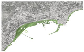
The landscape of the area of Pozzuoli and Averno and Lucrino lake, is full of elements and phenomena that represents the main points of a project based on the themes of connection, reclaimation and usability. Across the coast, there are green areas and S.I.C (site of community importance), but also a lot of industrial archaeology that could be reused for implanting new functions. According to the themes of the connections, we put in evidence roman archeology, roman paths and the morphology of the area, composed by lakes, cliffs, heights, sand beaches in order to create a green line that can put in link these elements with the abandoned industrial archaeology, hiking paths, port, the marine sites and the urban city center.

B.2 Mapping
-
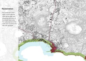
 The reclamation of the waters would make the coast bathing again and reduce the destruction of the present biodiversity. The redevelopment of the coastal area would stop the risk of the landslises.
 -
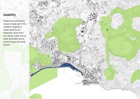
 Industrial archeologies occupy a large part of the coastline. Dispose of waste would be to expensive; reuse them as a lap for a path and as water purification plants would bring an economic income.
 -
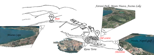 Along the coastline there can be identified some foreshortening linked to the main point of interest, like the view of cape miseno from the porto f Pozzuoli and the suggestive scenery offered by the Rione Terra from which it can be seen Astroni park and Monte Nuovo. Keeping on the shore line, the attention is captured by Nisida and the Gulf of Napoli. Working on these point of the area, there could be created prospective view that open itself towards a landscape unic in the world.
 -
 Linking back to our last presentation, we had quoted “Journey to Italy” written by Goethe, where he descrived the idyllic walks through the green areas of Pozzuoli. Furthermore Pozzuoli was also a destination of the Grand Tour in victorian times, and so we had resumed in a conceptual way this route through the creation of a green line which connect the punctuality highlighted.


B.3 Problem definition and priority setting
We have identified as objectives and project themes: the CONNECTIONS, not only with the neighboring cities, but also between the archaeological areas and the numerous points of interest of Pozzuoli; the RECLAMATION of the abandoned industries and areas with high tourism potential such as the coastal landscape; the USABILITY is to be understood almost as a result of previous actions, in order to increase the already high interest of internal investors, external investors and tourists. Considering the numerous risks of the area such as the hydro-geological and landslide area, and the many widespread problems on the whole territory due to illegal building, criminality, isolation and degradation of some areas, we have analyzed the position of the affected places and hypothesized that the solution could be to create an inclusive network, removing the areas from isolation and bringing them back to the splendor painted in the Neapolitan guaches, recreating cycle paths already appreciated in Roman times or the Grand Tour.


B.4 Theory reflection
According to some lectures, we have found the starting point for our assesment in the project.
We started from Landscape & Visual Impact Assessment (LVIA) to recognize the topography of our area, in which we considered the concept of a line who leads the fruitor (tourists and citizens) to three different panoramas. The first one is in the port of Pozzuoli where we encountered a degradation problem of archeological industries close to the beach [so our project is to redevelop those buildings implementing the port and the fishmarket with a maritime station that has a big responsability to welcome the tourists as the first sign that they see] that look at Monte di Procida and Averno and Lucrino Lakes ; then we have proceed with the unique area of ancient centre where is possible watch both directions from the top of Rione Terra all the bay with Capri and Ischia islands and the inner city till Astroni Park; last path drives the tourists till the gulf of Naples and Nisida.
About BlueHealth Enviromental Assessment Tool (BEAT) we have looked at the impact on citizens. A city with a good visual iimpact is a city with a pathway that is directly connected with tourism, social cohesion, air and water quality because of the good views there's a stress reduction, causated by a sense of place and satisfaction and of course with slow tourism and paths around the coast there's a good physical activity. So we have considered the psychologic models and aesthetic who are directly connected to the ecologic model with Ecosystem Services (ES) that lead the nature as primary source for health and well-being benefits.
At the end we have used the Coastal Character Assessment (CCA) method to analyse the coastline and the inner city releated to the archeological points and the environmental. Checking the maritime influences releated to the hinterland city we have highlight the human activities processing to the values of the project.
B.5 References
- http://www.archeoflegrei.it/necropoli-via-puteolis-neapolim/
- https://www.ilmattino.it/napoli/politica/napoli_bagnoli_porto_archeologia_industriale-2241587.html
- http://redazione.regione.campania.it/doc1/download/Elaborati_PRAE_2006/i_Cartografia/Tavola2_sic_zps/SicZps_na.pdf
- https://it.wikipedia.org/wiki/Viaggio_in_Italia_(saggio)
- http://www.archeoflegrei.it/grand-tour-flegreo-prima-raccolta/
- https://www.ilmattino.it/napoli/cronaca/campi_flegrei_luca_de_siena_solfatara-3253273.html
- https://bluehealth2020.eu/
- http://ec.europa.eu/environment/nature/natura2000/management/docs/art6/natura_2000_assess_en.pdf
Phase C – Strategy and Master Plan
C.1 Goal Setting
Our strategic planning objectives have been brought forward with awareness. We were focused principally on this green line (the whip green) that relate and combine all the goals with a simple reasoning. This line start slow with the green and blue infrastructures near the shoreline, this path create turism that make productive and sustainable the city (goal 11) , because create a connection where at the moment there isn't (goal 9) between the city and the sea with a cyclopedestrian path. It's also an intermodal change with the new maritime station redeveloping the archeoindustry area (goal 15) to connect with the islands. The path continue till the hinterland, reclaiming marine waters and natural areas (goal 14) .
"With the tourism we can have social changes, with the social changes we can destroy the criminality."

C.2 Spatial Strategy and Transect
Our acupuntures were specifically based on the port, on the archeologic industries, on the path and the open spaces. As explaned before we want to connect every part of the coast with a transect that helps citiziens where they need more.
-
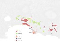
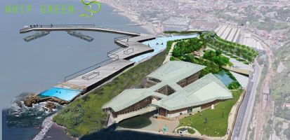 WHIP GREEN
 -
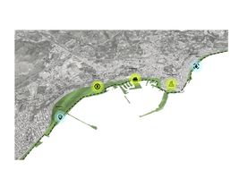 Transect
 -
 Detail transect
 -
 Detail acupuntures


C.3 From Theory of Change to Implementation
-
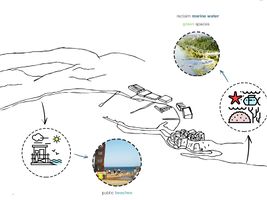
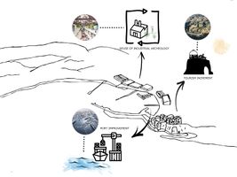
 According to the goals set at the beginning of the project we have developed our own in order to improve the quality of the place and the life of its inhabitants and visitors. Our area was initially a large industria, so it was absolutely necessary to restore and reclaim the brownfield areas, but also to allow the industry to regrow cleanly. As support for these new activities, infrastructures must be upgraded to ensure the flow from neighboring municipalities, reduce traffic and pollution and develop the interest of private investor in commercial activities and tourism attractors. A new clean network would allow the whole area to be more accessible and to let citizens and foreigners enjoy the beauty of this place rich in history and nature. At the moment this area has a high potential that is not exploited at best, but thanks to the maintenance and protection of the natural parks and marine environments, we hope it will return to the splendor of the past. For all these reasons with our project we hope to fulfill the prefixed objectives 7, 9, 11, 14 and 15 of the sustainable development.
 -
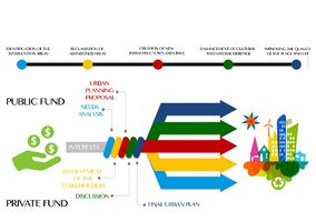 The development of the project must start with an increasing interest, at first public and then private in the area. Depending on the needs expressed by all the actors who take part in his life such as citizens, municipalities, users, investors and public authorities, a draft of a plan should be presented and evaluated, discussed again ad finally putted in place. It is very important for the maintenance of the progress that will be acquired over time to take into account of the satisfaction of the needs of those who work and live the activities and the places. Especially in a reality like the Neapolitan one where public space is not very respected and is vulnerable to rapid degradation.


C.4 References
- give a full list of the references you have used for this section
D. Process Reflection
We have learnt hot to work properly together, everyone of us knew something different about the site, some skills and how to work, so we have putted all together and we think that the outcomes is good. Maybe we can change the way how we started the approach without many information.
