Case Study G: Paljassaare-Pikakari: Difference between revisions
No edit summary |
Mohamed.aty (talk | contribs) |
||
| Line 88: | Line 88: | ||
5- Paljassaare Kalatööstus. | 5- Paljassaare Kalatööstus. | ||
6- kaelajarv. | |||
According to the green/blue infrastructure areas mentioned it’s notable that the most of the study area is occupied by industrial use, and the main three green areas (1, 2, 3) is likely to develop in the future, first to maintain the ecological quality of Paljassaare district and eliminate any potential disturbance from the industrial zone, second to increase the connectivity between the green zones and Pikakari beach and the city center. | |||
'' | '' | ||
Revision as of 08:08, 4 April 2019
>>>back to working groups overview
| Area | Paljassaare / Pikakari | |
| Place | Tallinn | |
| Country | Estonia | |
| Topics | Recreation, nature area, industry | |
| Author(s) | Constance, Franciska, Hélène, Mohamed, Neda, Pedram | |

| ||
Rationale
Paljassaare/Pikakari is a strategic site in the thematic of coastal landscapes because it is at the interface of Nature and Human activities. Indeed, Pikakari is a place close from the city centre (15mn by car) where tourists (mostly Tallinners) go to enjoy the sea and the beach. But close to the beach, there is also a Natura 2000 area with more than 80 species of protected birds. Thus, the area is quite fragile and a part of it is forbidden during nesting periods. Finally, industry is also present with the waste water treatment plant of Tallinn and Paljassaare port. In conclusion it is a site that can be very conflictual between industry and leisure/nature. Also, because of the activities established, the territory is divided and a long portion of coast on the west side of the Peninsula is not accessible. The challenge we identified is to make connections across the Peninsula.
Location and scope
You can edit this map with the map editor
A Landscape System Analysis
A.1 Landscape layers and their system context
Geomorphology, landscape units and coastal typology
Paljassaare peninsula is a part of the Tallinn bay and the Gulf of Finland. Most of Tallinn bay have an artificial coastline. However, the coast of this peninsula is mainly composed with beaches. These are made of sand, pebbles or rocks. The island began to emerge 700 years BC. This area is subjected to an isostatic uplift of the earth crust. It means that this is an area that emerges of around 2 mm every year. Initially the peninsula was divided in two islands. Paljassaare is a peninsula since the 1950s, when garbage was stored in the mud of the bay, between the island and the mainland. The location of the site, close to the passage of the boats, makes it vulnerable to waves. The wind also have an impact on the area, as there is no high point to protect it. Humans also have an impact on the site. It is partly because of the beach. Being close to the city-center, it is well frequented in summer. This brings some pressure on the site, because of the cars. There is also a water treatment plant on the peninsula, which could lead to soil and water pollution.
-
 Map of the to Islands from L. A. Mellin's "Atlas von Lieffland" 1798
 -
 Pikakari sand beach
 -
 Sand and pebbles beach
 -
 Rocks
Rocks


Land use
The main land uses in Paljaassare are divided into five; Transitional forest with mineral resources, open low and transfer bed, Industrial and commercial territories, Port and sparsely built up areas that is exist in the lower part of area and in industrial and commercial unit as well.
Predominant land use in area is industrial and commercial unit with some settlement, a main road is in the east with public transportation; this land use has connection with all other land uses exist there.According to development of area with analysis the different decades map shows the visible change is going to shrinking ports bounds and enlarging the industrial area and reaching the coast in the east with settlement.Guessing the port area will go to residential use in the future.
-
 Land use map,2000
 -
 land use map,2018
 -
 Legend
 -
 Paljassaare


Green/blue infrastructure
- Main green infrastructure:-
1- Paljassaare Special Conservation Area.
2- Paljassaare hoiuala laudtee.
3- Swamp area.
- Main blue infrastructure:-
4- Pikakari beach.
5- Paljassaare Kalatööstus.
6- kaelajarv.
According to the green/blue infrastructure areas mentioned it’s notable that the most of the study area is occupied by industrial use, and the main three green areas (1, 2, 3) is likely to develop in the future, first to maintain the ecological quality of Paljassaare district and eliminate any potential disturbance from the industrial zone, second to increase the connectivity between the green zones and Pikakari beach and the city center.
- You find my background material on green infrastructure in our reading list
- add 1-2 graphical representations to the image gallery, you can add more if you like
-
add a caption
-
add a caption
Actors and stakeholders
Paljassare peninsula is situated in the North of the municipality of Tallinn, in Harju county. It is part of the Northern Tallinn district. It is quite an industrial area with Tallinn waste treatment plant (Tallinna Vesi - Water of Tallinn - 70 ha) and Paljassaare Port belonging to Port of Tallinn (Tallinna Sadam) and several transportation companies as well as a railway. Around 50,000 inhabitants are living in the district. For planning in Estonia, the national government establishes the legal framework with laws and a national spatial plan. Then, counties do the county spatial plan and municipalities the comprehensive plan. Tallinn has a development plan for the period 2014-2020. According to one articles from 2018, Port of Tallinn would be looking to discard its last plots of Paljassaare harbor - most of it already sold over the past 10 years.
Who is affected highly but with low power? Who has high power but is not affected?
-
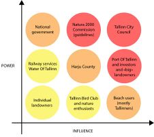 Powermap of Paljassaare peninsula

Sacred spaces and heritage
The cultural heritage of Paljassaare is manly characterized by it´s military use. In the past Paljassaare were divided into two small islands called Karli Islands. With the end of the Great Northern War on Estonian territory, Estonia was incorporated into Rus-sia. In 1727 the Russian leadership decided to strengthen the defences of the port of Tallinn. At this time the first military fortifications were built on Karli island (later Paljas-saare). In 1824 an artillery Tower was built on the smaller Karli island. The Tower became the unofficial name White Tower. Now a day only ruins of the Tower exist since the Russian troops destroyed the Tower during the Crimean War because of the fear that it will fall in the hands of the enemy. Before and during World War I a complex protecting system was built. The large com-plex of fortifications should protect St. Petersburg form attacks by the sea. The system was called Peter the Great´s naval fortress. The construction started on Paljassaare in 1912. The area between the mainland and the islands was filled and the result is the peninsula Paljassaare. The material to fill the area was collected during construction of the Mine Harbour. The construction of the complex protection system was never finished. Today only the ruins of the White Tower, the battery, the embankment of the railway and the Katariina Quay is left from the naval fortress.
-
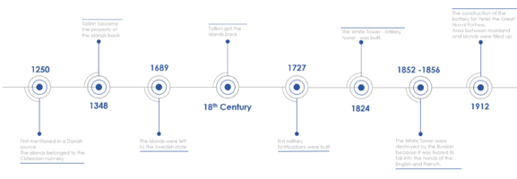 Timeline of the military history of Paljassaare

-
add a caption
-
add a caption
-
add a caption
Visual appearance and landscape narrative
- Which elements are essential for the landscape character?
- Has the landscape been painted or otherwise depicted, when and whom? Which elements are essential?
- Which narratives exist? Who has written about this landscape or depicted it in some way?
- You can add text and images
-
add a caption
-
add a caption
-
add a caption
A.2 Summary of you landscape system analysis and your development Targets
- You can summarize your findings with an DPSI(R) Model or a Spider Diagram
- Link back to the Sustainable Development Goals: Which goals are at risk?
- What is your hypothesis for this landscape?
- Visualise your hypothesis with one graphic/pict
- Are there any existing initiatives taking action in this landscape? Do you have a critical perspective on that?
- Add text and visuals
-
explain your analysis briefly in the caption
-
explain your hypthesis briefly in the caption
A.3 Theory reflection
- Reflect on at least three international policy documents in relation to their local landscape case
- choose one international, one European and one national document
- You can choose references from our reading list
- Scope: 250 words
A.4 References
Geomorphology, landscape units and coastal typology
- Maaamet [[1]]
- Great Paljassaare [[2]]
- Eurosion case study [[3]]
- Map of the to Islands from L. A. Mellin's "Atlas von Lieffland" 1798 [[4]]
- Pikakari sand beach [[5]]
- Sand and pebbles beach [[6]]
- Rocks [[7]]
![[4]](https://commons.wikimedia.org/wiki/File:Mellin_Atlas_von_Lieffland_Tallinn.png)
![[6]](https://commons.wikimedia.org/wiki/File:Paljassaare_hoiuala._01.jpg)
![[7]](https://commons.wikimedia.org/wiki/File:Paljassaare_laht_2010-07-14.jpg)
Land use
Green/blue infrastructure
Actors and stakeholders
- Article by Merilin Pärli on err.ee [[10]]
- Paljassaare Port [[11]]
- Port Of Tallinn [[12]]
- Tallinn City [[13]]
- Tallinna Vesi [[14]]
Sacred spaces and heritage
- www.portoftallinn.com/18th-century [[15]]
- citynature.eu [[16]]
- et.wikipedia.org/wiki/Paljassaare [[17]]
- www.estonica.org [[18]]
- www.estonica.org [[19]]
- www.estonica.org [[20]]
Visual appearance and landscape narrative
Phase B: Landscape Evaluation and Assessment
B.1 Assessment Strategy
- Based on the hypothesis derived from your previous landscape systems analysis you are now asked to define the goals for assessing the landscape. Your assessment is the basis for evaluating the landscape status.
- Which elements and phenomena need to be mapped, why and how?
- This a text contribution, max 250 words
B.2 Mapping
- As defined by your assessment strategy you conduct the mapping and present your findings here
- As a minimum, at least three different themes need to be mapped, you may choose more if needed
-
briefly explain the findings of your mapping
-
briefly explain the findings of your mapping
-
briefly explain the findings of your mapping
B.3 Problem definition and priority setting
- Give a summary of the major findings of your mapping process, what are the problems/potentials identified?
- Draw a problems/potentials map
- Set priorities for the most relevant issues
-
add caption here
B.4 Theory reflection
- Please reflect the assessment and evaluation methods used based on at least three readings
- Did you encounter limitations'
- 200 words test contribution
B.5 References
- give a full list of the references you have used for this section
Phase C – Strategy and Master Plan
C.1 Goal Setting
- Define strategic planning objectives based on the evaluation findings
- Link back to your original targets from section one and the Development Goals
- 150 words text contribution
C.2 Spatial Strategy and Transect
- translate your strategic goals into a vision
- develop a spatial translation of your vision
- exemplify your vision in the form of a transect with concrete interventions
- add map(s) and visualizations
-
add caption here
-
add caption here
-
add caption here
-
add caption here
C.3 From Theory of Change to Implementation
- For implementing your vision: Which partnerships are needed? Which governance model is required?
- Who needs to act and how? Draw and explain a change/process model/timeline
- Which resources are needed? On which assets can you build?
- add 150 words text and visuals
-
add caption here
-
add caption here
C.4 References
- give a full list of the references you have used for this section
D. Process Reflection
- Reflect in your intercultural and interdisciplinary team on the outcomes of your study
- Which limitations were you facing?
- What have you learnt from each other?
- What would you do differently next time?
- You can also use diagrams/visuals
- 250 words text