Case Study C: Averno: Difference between revisions
No edit summary |
|||
| Line 103: | Line 103: | ||
The Thermae, usually called “Temple of Apollo” is found on the Eastern shore of Lake Averno and consists of two levels enriched by niches and windows, the plan is octagonal outside and circular shaped on the inside. | The Thermae, usually called “Temple of Apollo” is found on the Eastern shore of Lake Averno and consists of two levels enriched by niches and windows, the plan is octagonal outside and circular shaped on the inside. | ||
The thermal baths at Terme Stufe di Nerone are positioned on the southern side of Lucrino Lake. The therapeutic benefits of thermal waters and the wonderful natural surroundings made the Terme Stufe di Nerone be very appealing to the citizens of ancient Rome. These thermal baths kept on improving over the years, becoming bigger up to the size that can be seen today. | The thermal baths at Terme Stufe di Nerone are positioned on the southern side of Lucrino Lake. The therapeutic benefits of thermal waters and the wonderful natural surroundings made the Terme Stufe di Nerone be very appealing to the citizens of ancient Rome. These thermal baths kept on improving over the years, becoming bigger up to the size that can be seen today. | ||
Lake Averno is a roughly circular lake, measuring up to 2km in circumference and 60m in depth. This lake was of immense importance to the Romance since they believed to be the entrance to Hades. The lake used to be owned by the House of Bourbon, then by an aristocratic family who then sold it to Cardillo family. Finally the lake was seized by law enforcement in 2010. | Lake Averno is a roughly circular lake, measuring up to 2km in circumference and 60m in depth. This lake was of immense importance to the Romance since they believed to be the entrance to Hades. The lake used to be owned by the House of Bourbon, then by an aristocratic family who then sold it to Cardillo family. Finally the lake was seized by law enforcement in 2010. | ||
Lake Lucrino is found one km south of Lake Averno and is separated from the sea by a slim strip of land. The Lake used to be bigger but due to the cratered volcanic cone of Monte Nuovo it became smaller sincer 1538. | Lake Lucrino is found one km south of Lake Averno and is separated from the sea by a slim strip of land. The Lake used to be bigger but due to the cratered volcanic cone of Monte Nuovo it became smaller sincer 1538. | ||
The Campi Flegrei Regional Park represents one of the most important parts of the region being a part of an intergrated landscape-cultural-environmental territorial system. The territory is characterized by the diverse landscape: coast, volcanic activity, thermal waters, natural ports and protected areas. | The Campi Flegrei Regional Park represents one of the most important parts of the region being a part of an intergrated landscape-cultural-environmental territorial system. The territory is characterized by the diverse landscape: coast, volcanic activity, thermal waters, natural ports and protected areas. | ||
Monte Nuovo is a volcanic cone that last erupted in 1528 due to damaging earthquakes and changes in land elevation. Its eruption is important because it was the first eruption described by a large number of witnesses. | Monte Nuovo is a volcanic cone that last erupted in 1528 due to damaging earthquakes and changes in land elevation. Its eruption is important because it was the first eruption described by a large number of witnesses. | ||
Revision as of 19:27, 4 April 2019
>>>back to working groups overview
| Area | Averno | |
| Place | Pozzuoli | |
| Country | Italy | |
| Topics | Volcanos, sensitive landscape | |
| Author(s) | Alexandra Lungu, Asif Adnan, Bianca Ivascu, Bruna Spagnol, Dario Esposito, Ema Plopeanu, Helene-Terese Jürgenson, Virginia Cuneo | |

| ||
Rationale
- Why do you think this case is relevant? What is your hypothesis considering the landscape challenges?
- Format: 3-4 sentences
Location and scope
A Landscape System Analysis
A.1 Landscape layers and their system context
Geomorphology, landscape units and coastal typology
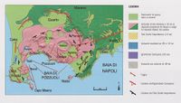
The formation of Italy as we know is the result of a series of complex sismic movements, starting from the collision between the African and European tectonic plaques. The sequence of collisions created the long chain of montains that crosses the country from south to north, the Alpenines. Smaller geografical accidents happened due to the phenomena, which, combined with the volcanic activities, led to the nowadays morphology.
In Pozzuoli, it is not different: lakes, shores and reefs tell us the evolution of the landscape. Today, both sismic and volcanic activities remain quiet, but not long ago, in the 1980's, Pozzuoli had to move around 50m ahead from its original location due to a rapid rising of the earth surface. Combined with the stress caused by populational growth, the town could a major change on its landscapes
-
 Geomorphology Pozzuoli. Source: http://ncpcstasia.weebly.com/il-rischio-vulcanico.html
 -
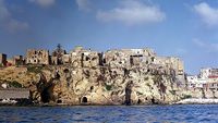 Coastal volcanic rocks. Source: https://www.repubblica.it/viaggi/2015/12/04/news/scoprire_campi_flegrei_napoli_campania-128801959/
 -
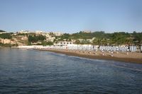 Low coast with volcanic rocks on the background. Source: https://lidonapoli.it


Land use
- settlements, infrastructure, agriculture, resource extraction, natural areas, energy production...
- description of evolution, status quo and driving forces, is the land use likely to change? Why is that? (approx 200 signs)
- add 1-2 graphical representations to the image gallery, you can add more if you like
-
add a caption
-
add a caption
-
add a caption
Green/blue infrastructure
The study area has strong elements of both blue and green infrastructure.
The blue elements are represented by the lakes of Averno and Lucrino, the seafront of Pozzuoli and Lucrino, the underwater archaeological reserve of Lucrino, and the Tyrrhenian Sea. Also, the entire area benefits from the geothermally heated groundwater.
The green elements are represented by the Monte Nuovo volcano (where the Regional Park of Campi Flegrei is located) a small part of the Monte Gauro, the crater of Averno, and the Lucrino Coast.
Although both green and blue elements have a strong presence in the territory, and are of high importance in the future economic development of the coast, they are undervalued (on a touristic perspective) because of the rather shallow links between them. Another issue which regards the Phlegrean coast, is represented by the level of pollution of the sea, which impacts on an ecological perspective the marine biodiversity, and on an economic perspective, the level of attractiveness of the area for tourists. (for as long as bathing on the coast is not allowed because of the sea pollution).
The proactive actions towards improving the green-blue infrastructure of the Averno region will result in an increase in ecological awareness, protection of the marine biodiversity, and in the development of the local economy.
-
add a caption
-
add a caption
Actors and stakeholders
Actors and stakeholders Thanks to the stakeholders' analysis it is possible to outline the actors of the study area and prioritize them by power and interest. The area is part of the Municipality of Pozzuoli, one of the 92 comuni belonging to the Metropolitan City of Naples and it is the main city of the Phlegrean fields. The leading institutional actors involved are the Basin Authority, the province of Naples (Metropolitan City of Naples), Campania region and, of course, the Municipality that is responsible for more practical decisions.
In particular, the Basin Authority is an institution that operates at a national, interregional and regional level, on the catchment areas and deals with the defense of the soil and subsoil and the rehabilitation of water. The water catchment areas of the Phlegraean fields are managed by the "Regional north-western Campania Basin Authority" that has strong power in this area. The Campania Region has had a high interest in the Phlegraean area in recent years. This can be explained by several reasons, above all the proximity to the Bagnoli area, of which it should constitute the natural continuation in view of the conversion of the entire area into an area dedicated to tourism and entertainment.
Other actors involved, but with a low level of power, are the citizens that actively participate in the social and economic life of the study area. To the business owners belong a huge piece of stakeholders with a pretty strong interest in the area that can not be excluded (bars, restaurants, dog park, sports activities, spa, diving center, tourist accommodations).
The tourists could be considered as actors in this system too: they have not a particular power of decision in the development of Pozzuoli Municipality, even if they are not pretty much affected by the urban changes. Also, the tourists can be part of this analysis even if they do not have the power of decision and can not directly influence the area.
- Draw a stakeholder and/or power map: Who is affected highly but with low power? Who has high power but is not affected?
-
add a caption
Sacred spaces and heritage
The study area consists of two very important landmarks: Apollo’s Temple and Terme Stufe di Nerone and also really important natural heritage elements: Lake Averno, Lake Lucrino, the Regional Park of Campi Flegrei and Monte Nuovo. The landmarks are close to the Lake Averno and Lake Lucrino and the natural heritage makes up about 40% of the study area.
The Thermae, usually called “Temple of Apollo” is found on the Eastern shore of Lake Averno and consists of two levels enriched by niches and windows, the plan is octagonal outside and circular shaped on the inside. The thermal baths at Terme Stufe di Nerone are positioned on the southern side of Lucrino Lake. The therapeutic benefits of thermal waters and the wonderful natural surroundings made the Terme Stufe di Nerone be very appealing to the citizens of ancient Rome. These thermal baths kept on improving over the years, becoming bigger up to the size that can be seen today.
Lake Averno is a roughly circular lake, measuring up to 2km in circumference and 60m in depth. This lake was of immense importance to the Romance since they believed to be the entrance to Hades. The lake used to be owned by the House of Bourbon, then by an aristocratic family who then sold it to Cardillo family. Finally the lake was seized by law enforcement in 2010. Lake Lucrino is found one km south of Lake Averno and is separated from the sea by a slim strip of land. The Lake used to be bigger but due to the cratered volcanic cone of Monte Nuovo it became smaller sincer 1538.
The Campi Flegrei Regional Park represents one of the most important parts of the region being a part of an intergrated landscape-cultural-environmental territorial system. The territory is characterized by the diverse landscape: coast, volcanic activity, thermal waters, natural ports and protected areas. Monte Nuovo is a volcanic cone that last erupted in 1528 due to damaging earthquakes and changes in land elevation. Its eruption is important because it was the first eruption described by a large number of witnesses.
- You may add a map and some images, please also explain in your caption why these elements are valuable
-
add a caption
-
add a caption
-
add a caption
Visual appearance and landscape narrative
- Which elements are essential for the landscape character?
- Has the landscape been painted or otherwise depicted, when and whom? Which elements are essential?
- Which narratives exist? Who has written about this landscape or depicted it in some way?
- You can add text and images
-
add a caption
-
add a caption
-
add a caption
A.2 Summary of you landscape system analysis and your development Targets
- You can summarize your findings with an DPSI(R) Model or a Spider Diagram
- Link back to the Sustainable Development Goals: Which goals are at risk?
- What is your hypothesis for this landscape?
- Visualise your hypothesis with one graphic/pict
- Are there any existing initiatives taking action in this landscape? Do you have a critical perspective on that?
- Add text and visuals
-
explain your analysis briefly in the caption
-
explain your hypthesis briefly in the caption
A.3 Theory reflection
- Reflect on at least three international policy documents in relation to their local landscape case
- choose one international, one European and one national document
- You can choose references from our reading list
- Scope: 250 words
A.4 References
- give a full list of the references you have used for this section
Phase B: Landscape Evaluation and Assessment
B.1 Assessment Strategy
- Based on the hypothesis derived from your previous landscape systems analysis you are now asked to define the goals for assessing the landscape. Your assessment is the basis for evaluating the landscape status.
- Which elements and phenomena need to be mapped, why and how?
- This a text contribution, max 250 words
B.2 Mapping
- As defined by your assessment strategy you conduct the mapping and present your findings here
- As a minimum, at least three different themes need to be mapped, you may choose more if needed
-
briefly explain the findings of your mapping
-
briefly explain the findings of your mapping
-
briefly explain the findings of your mapping
B.3 Problem definition and priority setting
- Give a summary of the major findings of your mapping process, what are the problems/potentials identified?
- Draw a problems/potentials map
- Set priorities for the most relevant issues
-
add caption here
B.4 Theory reflection
- Please reflect the assessment and evaluation methods used based on at least three readings
- Did you encounter limitations'
- 200 words test contribution
B.5 References
- give a full list of the references you have used for this section
Phase C – Strategy and Master Plan
C.1 Goal Setting
- Define strategic planning objectives based on the evaluation findings
- Link back to your original targets from section one and the Development Goals
- 150 words text contribution
C.2 Spatial Strategy and Transect
- translate your strategic goals into a vision
- develop a spatial translation of your vision
- exemplify your vision in the form of a transect with concrete interventions
- add map(s) and visualizations
-
add caption here
-
add caption here
-
add caption here
-
add caption here
C.3 From Theory of Change to Implementation
- For implementing your vision: Which partnerships are needed? Which governance model is required?
- Who needs to act and how? Draw and explain a change/process model/timeline
- Which resources are needed? On which assets can you build?
- add 150 words text and visuals
-
add caption here
-
add caption here
C.4 References
- give a full list of the references you have used for this section
D. Process Reflection
- Reflect in your intercultural and interdisciplinary team on the outcomes of your study
- Which limitations were you facing?
- What have you learnt from each other?
- What would you do differently next time?
- You can also use diagrams/visuals
- 250 words text