Case Study B: Pelguranna: Difference between revisions
| Line 101: | Line 101: | ||
<gallery caption=" " widths="200px" heights="150px" perrow="5"> | <gallery caption=" " widths="200px" heights="150px" perrow="5"> | ||
File:Samuel Waxelberg, Merimetsa wood (1688).png|Samuel Waxelberg, ''Merimetsa wood'' (1688) | File:Samuel Waxelberg, Merimetsa wood (1688).png|Samuel Waxelberg, ''Merimetsa wood'' (1688) | ||
File:Paul Burman, Winter landscape, Stroom Forest (1920-1930).jpg| | File:Paul Burman, Winter landscape, Stroom Forest (1920-1930).jpg|''Paul Burman'', Winter landscape, Stroom Forest ''(1920-1930)'' | ||
File:Paul Burman, Motive of Stroomi Beach (1920-1930).jpg|''Paul Burman | File:Paul Burman, Motive of Stroomi Beach (1920-1930).jpg|''Paul Burman'', Motive of Stroomi Beach ''(1920-1930)'' | ||
</gallery> | </gallery> | ||
Revision as of 21:13, 4 April 2019
>>>back to working groups overview
| Area | Pelguranna | |
| Place | Tallinn | |
| Country | Estonia | |
| Topics | please enter the main coast-related topics here | |
| Author(s) | Petar Jurički, Ferhat Türkoğlu | |

| ||
Rationale
- Why do you think this case is relevant? What is your hypothesis considering the landscape challenges?
- Format: 3-4 sentences
Location and scope
You can edit this map with the map editor
{{#display_map:
A Landscape System Analysis
A.1 Landscape layers and their system context
Geomorphology, landscape units and coastal typology
- Description of evolution, status quo and driving forces, is the coastal typology changing? Why is that? (approx 200 signs)
Pelguranna consist of fine sand and silt deposits (Stroomi) with a sandy foreshore which is included in the most relevant landscape units which are sea, coast, park and urban area. Major drivers in the area are geomorphological processes (waves, storms, tides, ice and erosions) and urbanisation. Taking everything into account it is evident that the coastal typology has potential to change in the future mostly depending upon the dominant drivers that were mentioned before with addition of sea level rise.
- add 1-2 graphical representations to the image gallery, you can add more if you like
-
 Classification of natural perched beaches using a geomorphic approach, source: Shari L Gallop, January 2011
 -
 Operational landscape units for SF Bay: using nature's jurisdictions to plan for sea level rise, source: San Francisco Estuary Institute, 2019
 -
 Seven types of coastlines, source: geography.name
 -
 Scheme of the glacial uplift process, source: : https://spotlight.unavco.org/station-pages/chur/chur.html
 -
 View on the Stroomi beach, source: http://www.arcovara.ee/et/blogi/220-arco-vara/106798-paerl-merimetsa-ja-stroomi-ranna-vahel


Land use
- settlements, infrastructure, agriculture, resource extraction, natural areas, energy production...
- description of evolution, status quo and driving forces, is the land use likely to change? Why is that? (approx 200 signs)
- add 1-2 graphical representations to the image gallery, you can add more if you like
-
add a caption
-
add a caption
-
add a caption
Green/blue infrastructure
- What are the major potential elements of a green/blue infrastructure network? Are these likely to change/disappear? Why is that?
- You find my background material on green infrastructure in our reading list
- add 1-2 graphical representations to the image gallery, you can add more if you like
-
add a caption
-
add a caption
Actors and stakeholders
- Pelguranna is characterized by soviet housing and grassland. Its lands belongs to the public administration of Pöhja-Tallinn municipality. Citizen associations can propose projects then agreed or refused by services from municipality of Tallinn, who comes directly to Edgar Savisaar, president of the center parti, in constant debate with the gouvernment .
- The actual ambition of Tallinn for its development is to improve the connection between the historic center and the coast. Because of the last russian dependance, the idea is to look at the nordic city's coasts (oslo, stockholm, helsinki) and follow. The access from the see has to be restored with a new estonian image. Therefore politicians decide with private investissors and contractors to implement high standing appartments and commercial buildings. In this case projects can be imposed to the district municipality and universities. Pelguranna can be affected by this approach because of tourists who come to visit the Stroomi beach. Residents, belonging to the working class and primarily russian can be threat.
-
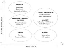 Powermap of Pelguranna

Sacred spaces and heritage
- Which places/elements hold cultural value and to whom?
- You may add a map and some images, please also explain in your caption why these elements are valuable
-
add a caption
-
add a caption
-
add a caption
Visual appearance and landscape narrative
- Which elements are essential for the landscape character?
Long shallow sandy beach hidden behind a thick layer of diverse Soviet time block houses from almost all decades of Soviet occupation. The beach is partly covered with pine forest and grassy areas.
- Stroomi beach has been an inspiration for centuries. One of the first visualizations of this landscape was created in 1688 by Samuel Waxelberg. It is a map depicting the region mostly in grassland. One of the earliest paintings of Stroomi beach were done by the Estonian artist Paul Burman. Both of his paintings were created in the second half of the 1920s – beginning of the 1930s, showing the landscape of the beach and Stroomi pine forest. In 1936 an illustration from the newspaper shows specific kind of lifestyle typical for the beach. The landscape still represents an inspiration for artists nowadays. In 2015 Estonian artist Kaspar Tamsalu painted the view from the window to the sea, showing the liveliness of the landscape.
- Both Pelguranna and Stroomi beach have often been mentioned in old newspaper from the second half of 1930s. These articles mainly describe progress and rebirth of Pelguranna and new plans for the development of the area. Additionally, the construction of “good-looking buildings” and modern life on the beach captures identity of the area at that time. Pelguranna also represents an inspiration for poets. The poem “My Tallinn” written by Kirke in 2011 depicts particular atmosphere of the area. In 2012 the well known Estonian contemporary poet Contra wrote “Facebook-born poem”.
-
 Samuel Waxelberg, Merimetsa wood (1688)
 -
 Paul Burman, Winter landscape, Stroom Forest (1920-1930)
 -
 Paul Burman, Motive of Stroomi Beach (1920-1930)
.png)
.jpg)
.jpg)
A.2 Summary of you landscape system analysis and your development Targets
- You can summarize your findings with an DPSI(R) Model or a Spider Diagram
- Link back to the Sustainable Development Goals: Which goals are at risk?
Point 3: Good health and well-being, Point 8: Decent work and economic growth, Point 11: Sustainable cities and communities, Point 13: Climate action, Point 15: Life on land
- What is your hypothesis for this landscape?
The current situation of Pelguranna shows a district with almost no vicinity with its location near the coastline. Buildings with four to six floors were built and used by the majority of russian rooted citizens. The green park appears to be a border between housing and leisure at the shoreline. The shore itself is mainly used by its surroundings. The hypothesis is based on two aspects. The natural process and man-made interactions. The shoreline will shrink and will narrow through the natural migration of sediments. The population on the other hand will grow and urban sprawl will be the result. Green open space areas which surround the buildings will get less and density of housing will rise.
- Visualise your hypothesis with one graphic/pict
- Are there any existing initiatives taking action in this landscape? Do you have a critical perspective on that?
- Add text and visuals
-
 DPSIR method of our system analysis

-
 The current situation of Pelguranna in our hypothesis

-
 The scenario of Pelguranna in our hypothesis

A.3 Theory reflection
- Reflect on at least three international policy documents in relation to their local landscape case
- choose one international, one European and one national document
- You can choose references from our reading list
- Scope: 250 words
A.4 References
- 1. Discomap.eea.europa.eu. (2019). [online] Available at: http://discomap.eea.europa.eu/map/Data/Milieu/OURCOAST_323_EE/OURCOAST_323_EE_Doc_TallinnEurosionCS.pdf [Accessed 27 Mar. 2019].
- 2. A summary of Geomorphology.(2019) [online] Available at:
https://www.researchgate.net/figure/Classification-of-natural-perched-beaches-using-a-geomorphic-approach_fig4_313393436 [Accessed 28 Mar. 2019]
- 3. Landscape Units. (2019) [online] Available at:
https://www.sfei.org/projects/OLUs [Accessed 28 Mar. 2019]
- 4. Types of Coastlines. (2019) [online] Available at:
http://geography.name/types-of-coastlines. [Accessed 28 Mar. 2019]
- 5. Anon, (2019). [online] Available at:
https://spotlight.unavco.org/station-pages/chur/chur.html [Accessed 1 Apr. 2019].
- 6. Arco Vara. (2019). Pärl Merimetsa ja Stroomi ranna vahel. [online] Available at:
http://www.arcovara.ee/et/blogi/220-arco-vara/106798-paerl-merimetsa-ja-stroomi-ranna-vahel [Accessed 1 Apr. 2019].
- 7. Dautancourt V. (2016). [online] Available at:
http://www.theses.fr/2016PA080004 [Accessed 1 Apr. 2019]
Phase B: Landscape Evaluation and Assessment
B.1 Assessment Strategy
- Based on the hypothesis derived from your previous landscape systems analysis you are now asked to define the goals for assessing the landscape. Your assessment is the basis for evaluating the landscape status.
- Which elements and phenomena need to be mapped, why and how?
- This a text contribution, max 250 words
B.2 Mapping
- As defined by your assessment strategy you conduct the mapping and present your findings here
- As a minimum, at least three different themes need to be mapped, you may choose more if needed
-
briefly explain the findings of your mapping
-
briefly explain the findings of your mapping
-
briefly explain the findings of your mapping
B.3 Problem definition and priority setting
- Give a summary of the major findings of your mapping process, what are the problems/potentials identified?
- Draw a problems/potentials map
- Set priorities for the most relevant issues
-
add caption here
B.4 Theory reflection
- Please reflect the assessment and evaluation methods used based on at least three readings
- Did you encounter limitations'
- 200 words test contribution
B.5 References
- give a full list of the references you have used for this section
Phase C – Strategy and Master Plan
C.1 Goal Setting
- Define strategic planning objectives based on the evaluation findings
- Link back to your original targets from section one and the Development Goals
- 150 words text contribution
C.2 Spatial Strategy and Transect
- translate your strategic goals into a vision
- develop a spatial translation of your vision
- exemplify your vision in the form of a transect with concrete interventions
- add map(s) and visualizations
-
add caption here
-
add caption here
-
add caption here
-
add caption here
C.3 From Theory of Change to Implementation
- For implementing your vision: Which partnerships are needed? Which governance model is required?
- Who needs to act and how? Draw and explain a change/process model/timeline
- Which resources are needed? On which assets can you build?
- add 150 words text and visuals
-
add caption here
-
add caption here
C.4 References
- give a full list of the references you have used for this section
D. Process Reflection
- Reflect in your intercultural and interdisciplinary team on the outcomes of your study
- Which limitations were you facing?
- What have you learnt from each other?
- What would you do differently next time?
- You can also use diagrams/visuals
- 250 words text