Case Study A.1: Pozzuoli-Solfatara-Astroni: Difference between revisions
| Line 62: | Line 62: | ||
[[File:1 urban fabric upload|Urban Fabric|300px | [[File:1 urban fabric upload.jpg|Urban Fabric|300px]] | ||
=== Green/blue infrastructure === | === Green/blue infrastructure === | ||
Revision as of 02:09, 5 April 2019
>>>back to working groups overview
Rationale
Keywords: mixt area, biodiversity, economic potential
Pozzuoli-Solfatara-Astroni area is very important as a mixt area, consisting in an urbanized area and a biodiversity and various landscape forms that highlight the potential of the area.
The further study case is structured in three steps: understanding coastal lanscape, evaluation and assessment for coastal landscape (a diagnostic of the area, what are the ”symptoms” and most important, the causes of them) and, finally, an integrated planning and design for coastal landscapes (ideas and projects to solve or improve the present situation discovered in the first two steps to protect and highlight the main characteristics of the zone).
Furthermore, the case study will have two big perspectives: the need of urbanization, touristic development and to cover the need for the locals and tourists (outlining the need for a stable and efficient economic system) and the need to protect the biodiversity and the landscape. This two need should merge, support each other and define a complex systems in which every element and relationship between them are to be considered in the future development of the area.
Location and scope
You can edit this map with the map editor
Phase A: Landscape System Analysis
A.1 Landscape layers and their system context
Geomorphology, landscape units and coastal typology
- Description of evolution, status quo and driving forces, is the coastal typology changing? Why is that? (approx 200 signs)
- add 1-2 graphical representations to the image gallery, you can add more if you like
- Yourcase landscapeunits1.jpg
add a caption
- Yourcase landscapeunits2.jpg
add a caption
Land use
Pozzouli was founded about 531 BC by Greek emigrants who called it Dicaearchia, the city of justice. After captured by Rome, it had the status of a Roman colony from 194 BC. The Romans called the city Puteoli which means small wells, perhaps due to the availability of numerous thermal-mineral water springs. After Roman conquering the East, the need to have a stopover open to traffic with it made Puteoli the Mediterranean port of Rome which made it a leading commercial centre and a cosmopolitan city. However, it declined with the fall of the Roman Empire and the gradual sinking of the Puteolan coast, caused by bradyseism, forced the inhabitants to leave the lower part and the harbor areas of the city and to settle on the hill at the end of the 5th century or at the beginning of the 6th century. Many traces of the Roman city survive, including well-preserved amphitheatre, baths and underground chambers while changes in the level of the land even caused temple porticoes along the shore to be submerged beneath the sea. The old Roman market, the Temple of Serapis of the 1st century AD was also partially submerged due to bradyseismic activity in the early 1970s.
Pozzuoli is on the Rome-Naples railway line and has a small commercial port. The fertile countryside supports a major food-processing industry in the town, which also engages in fishing and the manufacture of machinery. Many residents work in the iron- and steelworks at nearby Bagnoli. The local volcanic material is used for making the fine cement called pozzolana named after the town. The economy of this area is based largely on tourism, commerce, industry and agriculture. Between the two World Wars Pozzuoli was an important industrial pole for battleships weaponry. However, many factories have shut down during the last decades.
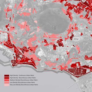
Pozzuoli the connecting point of rural, urban and industrial areas has gone through massive urbanization in the coastal area especially through last fifty years. In Pozouli-Solfatara-Astroni site, the urban fabric is denser in the hillside coastal area with mostly three to five storied buildings. There is a small continuous pedestrian friendly green belt in the coastline as social gathering place for the citizens. The area has still vast green areas of broad leaved forest, agriculture land, herbaceous plant vegetation, pastures as well as small urban green patches which are of great opportunity in this site. There is also dominance of industrial and commercial area close to the coast while some future planning can be thought about the abandoned industrial areas. A huge aeronautical academy is currently working in top of the hill providing professional trainings to young people. There are some other land uses like sports, recreation & also mineral extraction from solfatara, a semiactive volcano which is a famous touristic spot as well. Overall the current urban fabric and the commercial area are dominating the site & will possibly be dominating in future as well with a threat of converting landuses due to massive tourism and population growth.
Green/blue infrastructure
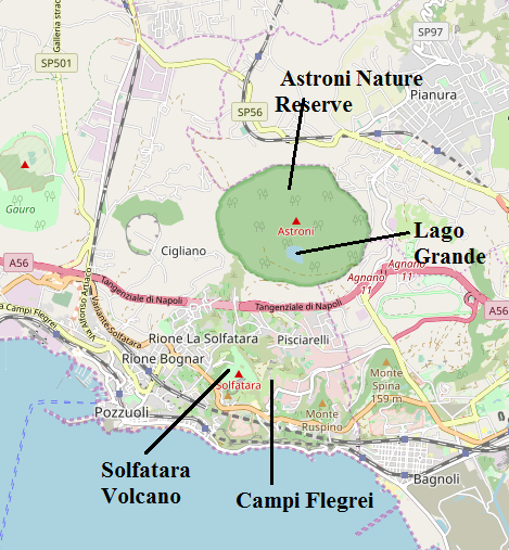
As the European commission defines it, the Green Infrastructure represents a network of healthy ecosystems that often provides cost-effective alternatives to traditional 'grey' infrastructure and offers many other benefits for both EU citizens and biodiversity. Some of the main benefits provided by GI would be improved habitats for wildlife, ecological corridors and ladscape permeability. Society as a whole would be affected, not just the biodiversity if the natural powerhouses are damaged. In the study Green infrastructure is well represented in Astroni Natural Craters Reserve, which is included in the Natura 2000 network since 1995, under Birds Directive and Habitats Directive protecting 31 species and 2 habitats. The flora and fauna are very various, known as one of the richest places of Naples for birds diversity. Also inside the reservation the blue infrastructure is represented by three small lakes: Lago Grande, Cofaniello Grande and Confaniello Piccolo. Additionally it is important to mention the famous Solfatara in the northeast, a semiactive volcano that exhales sulfurous vapours and gives vent to liquid mud and hot mineral springs. Altough the study presents an important economic and touristic development, it’s essential to maintain the balance between nature and citizens. The underlying principle is that the same area of land can offer multiple benefits, if its ecosystems are in a healthy state, GI serving the interests of both people and nature.
Actors and stakeholders
- Who is driving changes in this landscape? Who is affected by those changes?
- Draw a stakeholder and/or power map: Who is affected highly but with low power? Who has high power but is not affected?
- Your case your powermap.jpg
add a caption
Sacred spaces and heritage
- Which places/elements hold cultural value and to whom?
- You may add a map and some images, please also explain in your caption why these elements are valuable
- Your case sacredspace1.jpg
add a caption
- Your case sacredspace2.jpg
add a caption
- Your case sacredspace3.jpg
add a caption
Visual appearance and landscape narrative
- Which elements are essential for the landscape character?
- Has the landscape been painted or otherwise depicted, when and whom? Which elements are essential?
- Which narratives exist? Who has written about this landscape or depicted it in some way?
- You can add text and images
- Your case character1.jpg
add a caption
- Your case character2.jpg
add a caption
- Your case character3.jpg
add a caption
A.2 Summary of you landscape system analysis and your development Targets
- File:Dpsir sanja budinski.jpg
- Link back to the Sustainable Development Goals: Which goals are at risk?
- What is your hypothesis for this landscape?
- Visualise your hypothesis with one graphic/pict
- Are there any existing initiatives taking action in this landscape? Do you have a critical perspective on that?
DPSIR Framework is used for system analysis of the area. Population growth is recognized as a major driving force, which together with economic development puts pressures on the human and natural environment. As a consequence, there is landscape fragmentation, loss of natural and cultural heritage as well as deteriorated human wellbeing. A holistic approach to integrated development is a necessary response, which includes various steps for recognizing and conserving the values of the area.
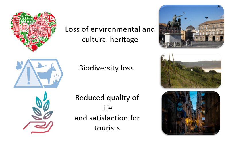
At the current state the urban sprawl, fragmentation of landscapes and ecosystems and as well as the reduced quality of environment are leading the area to three main consequences: Loss of environmental and cultural heritage, biodiversity loss and also reduced quality of life for locals and a decreasing number of tourists. As a result of the rapidly urbanizing areas, agriculture intensifies on remaining undeveloped land and is likely to expand to new areas, putting pressure on land resources. The loss of biodiversity can be related to the antrophic activities. Humans have destroyed and continue to destroy the habitats of species on a daily basis.
A.3 Theory reflection
- Reflect on at least three international policy documents in relation to their local landscape case
- choose one international, one European and one national document
- You can choose references from our reading list
- Scope: 250 words
A.4 References
- https://en.wikipedia.org/wiki/Economy_of_Naples
- https://www.britannica.com/place/Pozzuoli
- http://www.naplesldm.com/geology.php
- https://www.google.com/maps
- https://land.copernicus.eu/local/urban-atlas/urban-atlas-2012
- https://land.copernicus.eu/pan-european/corine-land-cover
- https://en.wikipedia.org/wiki/Pozzuoli, date 04.04.2019;
- https://en.wikipedia.org/wiki/Solfatara_(volcano), date 04.04.2019;
- http://eunis.eea.europa.eu/sites/IT8030007, date 04.04.2019;
- https://www.wwf.it/oasi/campania/cratere_degli_astroni/, date 04.04.2019;
- http://ec.europa.eu/environment/nature/ecosystems/index_en.htm, date 04.04.2019;
- Paolo Camilletti, Gianluca Lanzi, Natural and man-made landscape in the Phlegraean Fields: Linking identity and potentials for sustainable development. TRIA 20 (1/2018) 119-140/ e-ISSN 2281-4574. Accessed: 03.04.2019
- https://www.napoliunplugged.com/cratere-degli-astroni-nature-reserve.html, date 04.04.2019;
- http://ec.europa.eu/environment/nature/legislation/habitatsdirective/docs/Int_Manual_EU28.pdf, date 04.04.2019;
- https://www.eea.europa.eu/themes/landuse/land-cover-country-fact-sheets/it-italy-landcover-2012.pdf/view; date 04.04.2019;
- https://www.researchgate.net/publication/268096157_Coastal_Geomorphology_and_Sea-Level_Change; date 04.04.2019;
- https://urban.yale.edu/research/theme-4
- https://link.springer.com/article/10.1007/s12371-011-0033-1
Phase B: Landscape Evaluation and Assessment
B.1 Assessment Strategy
- Based on the hypothesis derived from your previous landscape systems analysis you are now asked to define the goals for assessing the landscape. Your assessment is the basis for evaluating the landscape status.
- Which elements and phenomena need to be mapped, why and how?
- This a text contribution, max 250 words
B.2 Mapping
- As defined by your assessment strategy you conduct the mapping and present your findings here
- As a minimum, at least three different themes need to be mapped, you may choose more if needed
- Your case your assessment mapping themel.jpg
briefly explain the findings of your mapping
- Your case your assessment mapping theme2.jpg
briefly explain the findings of your mapping
- Your case your assessment mapping theme3.jpg
briefly explain the findings of your mapping
B.3 Problem definition and priority setting
- Give a summary of the major findings of your mapping process, what are the problems/potentials identified?
- Draw a problems/potentials map
- Set priorities for the most relevant issues
- Your case problems potentials map.jpg
add caption here
B.4 Theory reflection
- Please reflect the assessment and evaluation methods used based on at least three readings
- Did you encounter limitations'
- 200 words test contribution
B.5 References
- give a full list of the references you have used for this section
Phase C – Strategy and Master Plan
C.1 Goal Setting
- Define strategic planning objectives based on the evaluation findings
- Link back to your original targets from section one and the Development Goals
- 150 words text contribution
C.2 Spatial Strategy and Transect
- translate your strategic goals into a vision
- develop a spatial translation of your vision
- exemplify your vision in the form of a transect with concrete interventions
- add map(s) and visualizations
- Your case spatial translaton vision.jpg
add caption here
- Your case transect.jpg
add caption here
- Your case transect detail1.jpg
add caption here
- Your case transect detail2.jpg
add caption here
C.3 From Theory of Change to Implementation
- For implementing your vision: Which partnerships are needed? Which governance model is required?
- Who needs to act and how? Draw and explain a change/process model/timeline
- Which resources are needed? On which assets can you build?
- add 150 words text and visuals
- Your case spatial your governance model.jpg
add caption here
- Your case spatial your process model.jpg
add caption here
C.4 References
- give a full list of the references you have used for this section
D. Process Reflection
- Reflect in your intercultural and interdisciplinary team on the outcomes of your study
- Which limitations were you facing?
- What have you learnt from each other?
- What would you do differently next time?
- You can also use diagrams/visuals
- 250 words text


