Case Study B.2: Rione Terra-Potus Julius: Difference between revisions
Alexandrai (talk | contribs) |
Alexandrai (talk | contribs) |
||
| Line 141: | Line 141: | ||
F_LUDWIG.jpg|''View of Rione Terra by Franz Ludwig in 1830'' | F_LUDWIG.jpg|''View of Rione Terra by Franz Ludwig in 1830'' | ||
C_CARELLI.jpg|''Oil on canvas by Consalvo Carelli from the 19th century'' | C_CARELLI.jpg|''Oil on canvas by Consalvo Carelli from the 19th century'' | ||
Mountain.jpg| ''The Crater of Monte Gauro by | Mountain.jpg| ''The Crater of Monte Gauro by William Hamilton 1776'' | ||
</gallery> | </gallery> | ||
Revision as of 18:37, 10 April 2019
>>>back to working groups overview
| Area | Case Study B.2: Rione Terra-Potus Julius | |
| Place | Rione Terra-Potus Julius | |
| Country | Italy | |
| Topics | Landscape System Analysis,Landscape Evaluation and Assessment,Strategy and Master Plan | |
| Author(s) | Adam Mihaela, Abhishek Passan, Francesca Lucido, Jlenia Graziuso, Kazi Zayed, Maria Nuciu, Maria Alexandra Ivănescu, Monica-Gabriela Amuza,
| |

| ||
Rationale
- Why do you think this case is relevant? What is your hypothesis considering the landscape challenges?
- First of all, the Case Study Rione Terra-Port Julius is quite interesting, especially by analyzing the dynamics of the economic, social and natural factors that make up it.
- Secondly, opening up to the Tyrrhenian Sea that favors commercial transport, can improve the quality of historical and recreational tourism, and so on.
- And last but not least, due to the volcanic relief that favored the creation of a fertile soil, generating an agricultural implementation. Of course there are also negative parts, with the change of the population and the urbanization that causes the degradation of the environment.
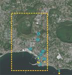
Location and scope
You can edit this map with the map editor
A Landscape System Analysis
A.1 Landscape layers and their system context
Geomorphology, landscape units and coastal typology
Rione Terra is located in the Province of Naples (Italy)(fig.1). From a geomorphologic point of view, the region is characterized by a graben-like depression.The depression floors are composed by broad alluvional plains.As a consequence of the tectonics present in this area, after a period of tectonic calm that allowed a mature erosional land scape to develop across the litho-structural complex (in Early Miocene to Middle Pliocene.)(fig.2,fig.3)
-
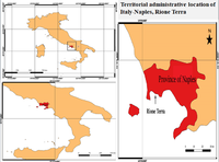 Fig.1:Administrative-territorial location of Naples - Rione Terra
 -
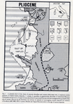 Fig.2:The outcrops of lower and middle plistocene marine deposits.
 -
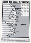 Fig.3:The geological and geomorphological records left in the area by lower and middle pleistocenic events.


Land use
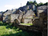
Napoli, being part of Italy, has undergone numerous changes over time. At present, the settlements have remained since ancient times, being numerous medieval monuments, castles, as well as ruins.(fig.4) The underground archaeological Rione Terra is a journey in the ancient Roman colony, Puteoli , founded in 194 BC and soon became a commercial port.
The course is located below the tuff rock overlooking the Gulf of Pozzuoli, between Nisida and Bay, and runs along the principal axes of the Roman city, hinges and decumani. Today, beneath Rione Terra, there lies a virtually untouched Roman town.
Archaeologists have excavated and restored a four thousand square metre area of the ancient Roman acropolis and its entire underground urban fabric. Now it can be seen the two main arteries of the acropolis flanked by millers’ shops, ancient taverns and the houses of fishermen.
Due to volcanic eruptions, the area became very fertile because of the lava minerals. Agriculture is based on grapes, tomatoes, lemons exotic fruits and native capers.(fig.5) From the infrastructure point of view, Napoli owns an airport, train lines across the city, buses. Being a port city, transport can also be done on water.(fig.6)
-
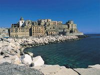 Fig.4:Rione Terra-Ancient ruin
 -
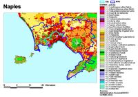 Fig.5: Land use
 -
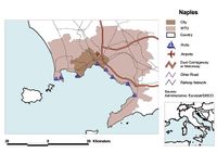 Fig.6: Infrastructure


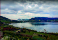
Green/Blue infrastructure
The studied area has a high potential of development regarding green-blue infrastructure due to the dominant presence in the territory of the Gauro Mountain but also for the acces to the Mediterranean Sea.
Gauro Mountain is the volcanic formation with the highest pick it’s a part of the Regional Park situated in the Phlegraean Fields. This area is very important for the ecosystem and it’s also a protected area part of the Natura 2000 Network.
The mountain is an identity element for this zone, with flora and fauna specific for this type of territory and charcaterized by thick mediterranean vegetation like chestnut in the north side and plants like cistus[1], mastic trees[2] and myrtle[3] in the steep west side. Also, in the past, in the neigbhourhood territory of the mountain , was cultivated vines , valuable agriculture areas nowadays.
This important elements of green-blue infrastructure is in a continue changing because of the human intervention and also the urbanization causing in more cases pollution of the environment. We can see this urban development also in the crater of the Mount Gauro , where now is the Carney Park- a recreational facility of the US Navy that can't be visited by other users diffrent of the US Navy stuff. So, because of this limitation, the landscape in this part, from the top of the mountain is not valued as it should be.
Natura 2000 Network prevents this type of intervation in the green protected area, and by improving the green-blue infrastructure in a sustainable manner, the ecosystem will be protect better(marine and mountain biodiversity), reaching a sustainable development of the local economy and also of the urbanization.
-
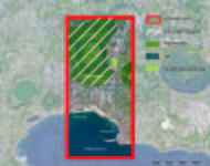 Green-Blue Infrastructure
 -
 Gauro Mountain
 -
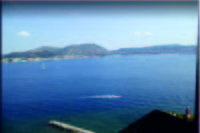 Portus Julius
 -
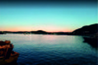 Pozzuoli Port
 -
 Top of Gauro Mountain
 -
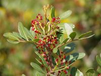 Mastic tree
 -
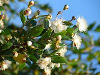 Myrtle
 -
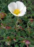 Cistus


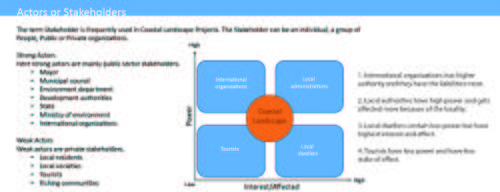
Actors and stakeholders
Strong Actors in the Rione Terra-Potus Julius area : Mayor, Municipal council, Environment department, Development authorities, State, Ministry of environment, International organizations.
Weak actors: Local residents, Local societies, Tourists, Fishing communities. Here, International organizations has higher authority and they have the liabilities most. Local authorities have high power and gets affected more because of the locality. Local dwellers contain less power but have highest interest and effect. Tourists have less power and have less stake or effect.
-
 Rione Terra powermap

Sacred spaces and heritage
The Rione Terra quarter represents the historic city of Pozzuoli, founded by the Romans the 2nd century B.C.
-
 Map of heritage sites
 -
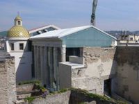 Cathedral of Pozzuoli
 -
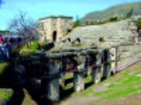
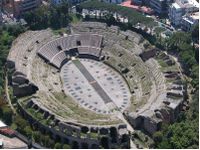 Anfiteatro Flavio
 -
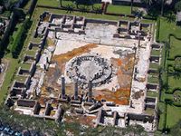 Temple of Serapis
 -
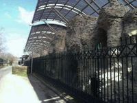 Necropoli di S. Vito
 -
 Necropoli di Via Celle
 -
 Stadio di Antonino Pio


Visual appearance and landscape narrative
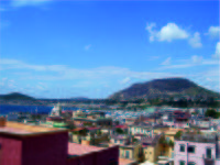
Rione Terra is the first settlement of Pozzuoli. It is placed on a hill, which stands 33 m from the sea. Its position has always been positive to control the arrival of the enemies from the sea and from the land. Unfortunately, due to bradyseisms and especially the earthquake in 1984, Rione Terra was the subject of a great work of retraining and restauration. Finally, it was opened in 2014. Today, this area is very interesting to visit because it is a really overlapping of housing layers.
Through the years, many important people had been inspired from this place. A great example, which is able to summarise the essence, is Alberto Angela's quote. The italian paleontoligist tells:There is a neighborhood where chapters of Pozzuoli's long history are overlapped like the pages of a book.
While,between VIII and IX century A.D., there are some lines written in the Acts of St. Peter and Paul, from the apocryphal Gospel, they justified the sinking of the city to a miracle. It was opereted by the apostle Paolo to punish the city where was executed the master of the ship, whit which the saint arrived from Orient. Moreover, also the geographer Strabone, explains his thoughts about. He considered the fortress as the landing of the exiles of the island of Samo, who founded Dicearchia, the government of the correct ones.
Thanks to its suggestive character this area has been also the subject of lots of paintings.
In 1764 G.P.Bollori re-made a painting, which was lost. This one showed the port area and that right there was a temple dedicated to Apollo, it was located on the first acropolis of Pozzuoli.
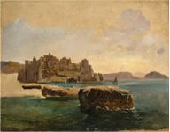
There are also other views from the nineteenth century, made by Franz Ludwig(1830) and the canvas made by Consalvo Carelli.
-
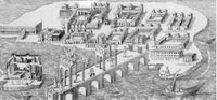 Painting by Bollori of Rione Terra in 1764
 -
 View of Rione Terra by Franz Ludwig in 1830
 -
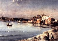 Oil on canvas by Consalvo Carelli from the 19th century
 -
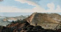 The Crater of Monte Gauro by William Hamilton 1776


A.2 Summary of you landscape system analysis and your development Targets
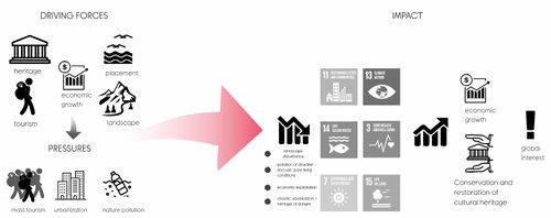
- You can summarize your findings with an DPSI(R) Model or a Spider Diagram
- Link back to the Sustainable Development Goals: Which goals are at risk?
- What is your hypothesis for this landscape?
- Visualise your hypothesis with one graphic/pict
- Are there any existing initiatives taking action in this landscape? Do you have a critical perspective on that?
- Add text and visuals
-
 explain your analysis briefly in the caption

-
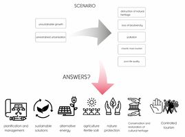 Our hypothesis is that the unsustainable growth and chaotic urbanization are the causes for pollution, distruction of the natural heritage and loss of biodiversity who also led to a low quality life. The answer for solving the problems in this scenario is a sustainable development using alternative energy, sustainable solution and planfication for the urban development. We thought that other solutions for the problems is to protect the nature and cultural heritage by preserving and restoring it. Also, near the mountain, because of the volcanic eruptions , the soil here is more fertile, the land having agricultural potential, so we can value this potential in our future development strategy.

A.3 Theory reflection
- Reflect on at least three international policy documents in relation to their local landscape case
- choose one international, one European and one national document
- You can choose references from our reading list
- Scope: 250 words
A.4 References
- 1.https://www.researchgate.net/profile/Antonio_Santo2/publication/258513279_Geomorphology_and_neotectonic_evolution_of_a_sector_of_the_Tyrrhenian_flank_of_the_Southern_Apennines_Region_of_Naples_Italy/links/0deec529093c63b31d000000/Geomorphology-and-neotectonic-evolution-of-a-sector-of-the-Tyrrhenian-flank-of-the-Southern-Apennines-Region-of-Naples-Italy.pdf (text+fig.2,fig.3)
- 2.http://www.napolike.com/tourism/place/district-earth-pozzuoli-napoli/
- 3.http://www.pressreader.com
- 4.https://www.likealocalguide.com/naples/rione-terra(fig.4)
Phase B: Landscape Evaluation and Assessment
B.1 Assessment Strategy
- Based on the hypothesis derived from your previous landscape systems analysis you are now asked to define the goals for assessing the landscape. Your assessment is the basis for evaluating the landscape status.
- Which elements and phenomena need to be mapped, why and how?
- This a text contribution, max 250 words
B.2 Mapping
- As defined by your assessment strategy you conduct the mapping and present your findings here
- As a minimum, at least three different themes need to be mapped, you may choose more if needed
-
briefly explain the findings of your mapping
-
briefly explain the findings of your mapping
-
briefly explain the findings of your mapping
B.3 Problem definition and priority setting
- Give a summary of the major findings of your mapping process, what are the problems/potentials identified?
- Draw a problems/potentials map
- Set priorities for the most relevant issues
-
add caption here
B.4 Theory reflection
- Please reflect the assessment and evaluation methods used based on at least three readings
- Did you encounter limitations'
- 200 words test contribution
B.5 References
- give a full list of the references you have used for this section
Phase C – Strategy and Master Plan
C.1 Goal Setting
- Define strategic planning objectives based on the evaluation findings
- Link back to your original targets from section one and the Development Goals
- 150 words text contribution
C.2 Spatial Strategy and Transect
- translate your strategic goals into a vision
- develop a spatial translation of your vision
- exemplify your vision in the form of a transect with concrete interventions
- add map(s) and visualizations
-
add caption here
-
add caption here
-
add caption here
-
add caption here
C.3 From Theory of Change to Implementation
- For implementing your vision: Which partnerships are needed? Which governance model is required?
- Who needs to act and how? Draw and explain a change/process model/timeline
- Which resources are needed? On which assets can you build?
- add 150 words text and visuals
-
add caption here
-
add caption here
C.4 References
- give a full list of the references you have used for this section
D. Process Reflection
- Reflect in your intercultural and interdisciplinary team on the outcomes of your study
- Which limitations were you facing?
- What have you learnt from each other?
- What would you do differently next time?
- You can also use diagrams/visuals
- 250 words text