COLAND Case Study 2020 - Dunkerque (West): Difference between revisions
| Line 28: | Line 28: | ||
= Rationale = | = Rationale = | ||
'This case is a perfect illustration of the location of industries in a very natural landscape, where conflicts between the two exist and where compromises must constantly be found. | |||
Today, we can see that attempts are being made to protect certain areas in order to conserve the fauna and flora specific to this type of environment, while at the same time continuing to develop the port industry, which occupies an important part of the landscape, especially along the coast. It is therefore interesting to analyse this situation and find solutions to reconcile these different issues in the landscape. | Today, we can see that attempts are being made to protect certain areas in order to conserve the fauna and flora specific to this type of environment, while at the same time continuing to develop the port industry, which occupies an important part of the landscape, especially along the coast. It is therefore interesting to analyse this situation and find solutions to reconcile these different issues in the landscape.' | ||
= Location and scope = | = Location and scope = | ||
Revision as of 14:01, 18 February 2020
>>>back to working groups overview
| Area | please enter the area name here | |
| Place | please enter the town/village name | |
| Country | please enter the country here | |
| Topics | please enter the main coast-related topics here | |
| Author(s) | Please enter your name(s)- optional | |

| ||
Rationale
'This case is a perfect illustration of the location of industries in a very natural landscape, where conflicts between the two exist and where compromises must constantly be found. Today, we can see that attempts are being made to protect certain areas in order to conserve the fauna and flora specific to this type of environment, while at the same time continuing to develop the port industry, which occupies an important part of the landscape, especially along the coast. It is therefore interesting to analyse this situation and find solutions to reconcile these different issues in the landscape.'
Location and scope
You can edit this map with the map editor
A Landscape System Analysis
A.1 Landscape layers and their system context
Geomorphology, landscape units and coastal typology
From a geomorphological point of view, the territory has been influenced by two dominant factors: the maritime regime (the English Channel/North Sea) and hydrography. The area is part of the maritime or alluvial plain known as the Flemish maritime plain, which continues towards Belgium and the Netherlands. Its boundaries are defined by the former Aa delta. This type of geomorphological formation indicates that the area is highly marked and is changing noticeably as a result of the more or less rapid sedimentation phenomena. According to the geology map, we are faced with a recent Quaternary formation characterized by two fundamental typologies: dune formations and bay sealing sediments (sand and mud). The coastline has no hard formation at any point and is therefore very unstable on a human scale. To the north, the Channel's course narrows to only 35km, which has an influence on the sedimentary regimes. The foreshore is highly developed west of Dunkirk between 1000 and 1500m wide and the dune formations along the coastline reach 500 to 1000m wide. The morphology of the seabed influences the sedimentation and erosion mechanisms along the coast. The topography of the seabed is dominated by the presence of the Bancs de Flandres. They provide some protection for the coast by absorbing some of the energy of the swells. The evolution of the coastline is due to erosion and sedimentation phenomena, whether natural (wind, swell, tide) or anthropogenic (dyke, urbanisation, canal, etc.). From Calais to Dunkirk, the coastline has tended to become rather fatter, with the shoreline growing by around 500 m over the last 300 or 400 centuries. This is due to several factors, including the welding to the shore of the sandy banks encountered in front of the coastline. In particular, the closure of the Mardyck channel, which was favoured by the construction of the Dunkirk jetties, has led to a significant advance in the shoreline. The current coastal regime is, to a large extent, the legacy of changes in the seabed and coastline that have taken place during these sea level variations.
On the coast, swells have a predominant action on sedimentation, while offshore, currents have a predominant action on sedimentation. The action of the swells is translated by a lateral transport (coastal transit) but also by a sorting in the profile which results in a decrease of the granulometry of the coast to the bottom. The distribution is done as such: where the currents are strongest, the materials are the largest and where they are weakest, the sediments are the finest.
The progression of the coastline to the east is the result of a natural phenomenon accentuated by the construction of dykes in order to gain land. The harbour piers, which acted as groynes, prevented the movement of sediment and caused the beaches east of Dunkirk to become thinner and west to become fatter. Over time the surface area of the dune cord has shrunk considerably. The development of urbanization is the main cause (40%). The remaining dunes have also lost height. From the landscape point of view, this maritime plain, also called "Bootland" (bare country), is characterized by a little marked relief whose altitude is lower than 5m for the majority. The landscape is open and strongly exposed to the wind, added to its agronomic richness, there is little afforestation. There are therefore large areas of open cultivation, beets, chicory, flax, vegetables and cereals. It is criss-crossed by polders and an extensive network of canals whose flow is constantly regulated. It is separated from the North Sea by a dune strip. This physical characteristic explains the ease of urban development (no relief hindrance). The natural orientation of the territory thus dictates the organisation of human settlements, which are part of this network (infrastructures, urbanisation, etc.). There are two major landscape entities: the dune belt and the channelled maritime plain. The channelled maritime plain is the result of strong human intervention in its environment. In the Middle Ages, the plain was polderised, then the marshes were drained from the 12th century onwards through the setting up of the watering system. From the period when the territory was only sea, the landscape keeps strong characteristics: the horizons, the wind, the presence of water, which make it a landscape in transition, between land and sea. Successive urbanisations, the installation of port facilities on the seafront, the development of infrastructures, have modified the legibility of these large geographical entities, thus introducing strong ruptures.
The beach and dune areas bear witness to the original landscape of the seafront. They are characterized by a high ecological richness (ZNIEFF, SIC) and a landscape of meadows and sand dunes.
- add 1-2 graphical representations to the image gallery, you can add more if you like
-
add a caption
-
add a caption
Land use
- settlements, infrastructure, agriculture, resource extraction, natural areas, energy production...
- description of evolution, status quo and driving forces, is the land use likely to change? Why is that? (approx 200 signs)
- add 1-2 graphical representations to the image gallery, you can add more if you like
-
add a caption
-
add a caption
-
add a caption
Green/blue infrastructure
- What are the major potential elements of a green/blue infrastructure network? Are these likely to change/disappear? Why is that?
- You find my background material on green infrastructure in our reading list
- add 1-2 graphical representations to the image gallery, you can add more if you like
-
add a caption
-
add a caption
Actors and stakeholders
Our area covers the borough of Dunkirk as well as the borough of Saint-Omer. In this area, we are dealing with a group of municipalities called "Dunkerque Grand Littoral". This inter-municipal cooperation brings together 17 municipalities and its competences revolve around economic development, waste management, town planning, mobility and transport, energy, water management and sanitation, housing and roads. Finally, it intervenes in the fields of health, sport, justice, education, major risks and accessibility. This cooperative is managed by a President and its Vice-Presidents. This cooperation can therefore be considered as the leading player in the area. In the commune of Saint-Omer, which represents only a small part of our area, we find the Platier d'Oye national nature reserve. It is managed by the EDEN 62 mixed syndicate, which brings together, on an equal footing, elected members of the Departmental Council and local authorities. This syndicate is a will of the Pas-de-Calais Department and its missions are to protect, develop and raise awareness.'
Then the second player would be represented by the various mayors of these 17 communes. They play a double role: state agent and commune agent. As an agent of the state, the mayor fulfils the following administrative functions: - the publication of laws and regulations - the organisation of elections - the legalization of signatures. It may be responsible for the execution of general security measures. As an agent of the municipality, he is responsible for the execution of the decisions of the municipal council and acts under the control of this council. He represents the municipality in court, awards contracts, signs contracts, prepares the budget, and manages the assets. In the area of town planning, he issues building permits and other town planning authorisations on behalf of the municipality. By its municipal by-laws, it can regulate traffic, parking, bathing and navigation in its municipality or prescribe works in case of endangerment of the population or the environment.
Finally, the third and last actor is the people living and working in the area, not forgetting tourists. Thus, we find the port of Dunkirk and all the workers associated with it. It should be noted that this port is classified as France's 3rd largest port, renowned as a port for large bulk goods destined for its many industrial establishments. In other words, it plays an essential role in the landscape. There are also many commercial zones within our study area, which also impact the landscape. The farmers who structure the landscape with their plots of land cannot be overlooked either. Finally, let us not forget of course the inhabitants who live the landscape on a daily basis, as well as the tourists who impact the landscape to a greater or lesser extent depending on their presence.
So it can therefore be said here that it is the inhabitants and workers (mainly farmers) who are affected by the changes made to the landscape. Nor should we forget the local fauna and flora that depend on the actions initiated in the landscape. Hence the importance of having protected areas such as the Platier d'Oye Nature Reserve.
-
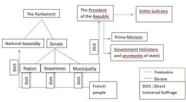 How the french republic works
 -
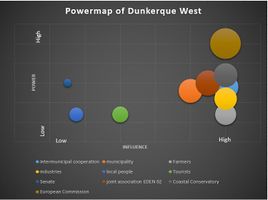 Power Map of western Dunkirk


Sacred spaces and heritage
- Which places/elements hold cultural value and to whom?
- You may add a map and some images, please also explain in your caption why these elements are valuable
-
add a caption
-
add a caption
-
add a caption
Visual appearance and landscape narrative
- Which elements are essential for the landscape character?
- Has the landscape been painted or otherwise depicted, when and whom? Which elements are essential?
- Which narratives exist? Who has written about this landscape or depicted it in some way?
- You can add text and images
-
add a caption
-
add a caption
-
add a caption
A.2 Summary of your landscape system analysis and your development targets
- You can summarize your findings with an DPSI(R) Model or a Spider Diagram
- Link back to the Sustainable Development Goals: Which goals are at risk?
- What is your hypothesis for this landscape?
- Visualise your hypothesis with one graphic/pict
- Are there any existing initiatives taking action in this landscape? Do you have a critical perspective on that?
- Add text and visuals
-
explain your analysis briefly in the caption
-
explain your hypthesis briefly in the caption
A.3 Theory reflection
- Reflect on at least three international policy documents in relation to their local landscape case
- choose one international, one European and one national document
- You can choose references from our reading list
- Scope: 250 words
A.4 References
- give a full list of the references you have used for this section
Phase B: Landscape Evaluation and Assessment
B.1 Assessment Strategy
- Based on the hypothesis derived from your previous landscape systems analysis you are now asked to define the goals for assessing the landscape. Your assessment is the basis for evaluating the landscape status.
- Which elements and phenomena need to be mapped, why and how?
- This a text contribution, max 250 words
B.2 Mapping
- As defined by your assessment strategy you conduct the mapping and present your findings here
- As a minimum, at least three different themes need to be mapped, you may choose more if needed
-
briefly explain the findings of your mapping
-
briefly explain the findings of your mapping
-
briefly explain the findings of your mapping
B.3 Problem definition and priority setting
- Give a summary of the major findings of your mapping process, what are the problems/potentials identified?
- Draw a problems/potentials map
- Set priorities for the most relevant issues
-
add caption here
B.4 Theory reflection
- Please reflect the assessment and evaluation methods used based on at least three readings
- Did you encounter limitations'
- 200 words test contribution
B.5 References
- give a full list of the references you have used for this section
Phase C – Strategy and Master Plan
C.1 Goal Setting
- Define strategic planning objectives based on the evaluation findings
- Link back to your original targets from section one and the Development Goals
- 150 words text contribution
C.2 Spatial Strategy and Transect
- translate your strategic goals into a vision
- develop a spatial translation of your vision
- exemplify your vision in the form of a transect with concrete interventions
- add map(s) and visualizations
-
add caption here
-
add caption here
-
add caption here
-
add caption here
C.3 From Theory of Change to Implementation
- For implementing your vision: Which partnerships are needed? Which governance model is required?
- Who needs to act and how? Draw and explain a change/process model/timeline
- Which resources are needed? On which assets can you build?
- add 150 words text and visuals
-
add caption here
-
add caption here
C.4 References
- give a full list of the references you have used for this section
D. Process Reflection
- Reflect in your intercultural and interdisciplinary team on the outcomes of your study
- Which limitations were you facing?
- What have you learnt from each other?
- What would you do differently next time?
- You can also use diagrams/visuals
- 250 words text