COLAND Case Study 2020 - Reiu: Difference between revisions
| Line 61: | Line 61: | ||
=== Green/blue infrastructure === | === Green/blue infrastructure === | ||
1/3 of the area consists of a landscape reserve and forest growing on it. There are health trails that can be used all year round. Under protection are the bird species: Pernis apivorus, Bonasa bonasia, Strix uralensis, Caprimulgus europaeus and the plant species: Listeria ovata, Epipactis helleborine, Dactylorhiza incarnata, Huperzia selago. In the coastal meadows the reed has grown and the characteristic vegetation is disappearing. To restore it, an urban cow project has been launched: in summer, cows live on coastal meadows and eat less reed, and the former vegetation is restored. | |||
Elements of blue infrastructure: | |||
Pärnu bay | |||
Reiu river, border of study area | |||
Pärnu river | |||
Forces of changing (Peoples treatment): | |||
real estate developments in coastal areas and near highways - which can lead to the disappearance of forests, as well as the conversion of protected forests to wind. | |||
Increase in the number of holiday tourists on the beach – which may have negative impact on the cleanliness of the water and the shoreline | |||
increasing ATV and bicycle users; and uncontrolled use of forest paths – may endanger the conservation of protected species | |||
The construction of the Rail Baltic railway - may adversely affect the landscape protection area in the central part of the study area. Completed railroads can also degrade residents' access to health trails in the forest | |||
Coastal conditions can also change due to natural forces: | |||
the high shoreline damages the high shore near Reiu village, | |||
climate change may cause coastal meadows and buildings closer to the sea to be submerged. | |||
<gallery caption=" " widths="200px" heights="150px" perrow="5"> | <gallery caption=" " widths="200px" heights="150px" perrow="5"> | ||
Revision as of 10:21, 20 February 2020
>>>back to working groups overview
| Area | Reiu-Raeküla | |
| Place | Pärnu county | |
| Country | Estonia | |
| Topics | please enter the main coast-related topics here | |
| Author(s) | Suvi Pohjola-Stenroos, Renata Villalobos Anaya, Karin Rea, Mirjam Manglus, Airi Loid, Massooma Abbas | |
|
| ||

Rationale
- Why do you think this case is relevant? What is your hypothesis considering the landscape challenges?
- Format: 3-4 sentences
Location and scope
You can edit this map with the map editor
A Landscape System Analysis
A.1 Landscape layers and their system context
Geomorphology, landscape units and coastal typology
- Description of evolution, status quo and driving forces, is the coastal typology changing? Why is that? (approx 200 signs)
- add 1-2 graphical representations to the image gallery, you can add more if you like
-
add a caption
-
add a caption
Land use
- settlements, infrastructure, agriculture, resource extraction, natural areas, energy production...
- description of evolution, status quo and driving forces, is the land use likely to change? Why is that? (approx 200 signs)
- add 1-2 graphical representations to the image gallery, you can add more if you like
-
add a caption
-
add a caption
-
add a caption
Green/blue infrastructure
1/3 of the area consists of a landscape reserve and forest growing on it. There are health trails that can be used all year round. Under protection are the bird species: Pernis apivorus, Bonasa bonasia, Strix uralensis, Caprimulgus europaeus and the plant species: Listeria ovata, Epipactis helleborine, Dactylorhiza incarnata, Huperzia selago. In the coastal meadows the reed has grown and the characteristic vegetation is disappearing. To restore it, an urban cow project has been launched: in summer, cows live on coastal meadows and eat less reed, and the former vegetation is restored. Elements of blue infrastructure: Pärnu bay Reiu river, border of study area Pärnu river Forces of changing (Peoples treatment): real estate developments in coastal areas and near highways - which can lead to the disappearance of forests, as well as the conversion of protected forests to wind. Increase in the number of holiday tourists on the beach – which may have negative impact on the cleanliness of the water and the shoreline increasing ATV and bicycle users; and uncontrolled use of forest paths – may endanger the conservation of protected species The construction of the Rail Baltic railway - may adversely affect the landscape protection area in the central part of the study area. Completed railroads can also degrade residents' access to health trails in the forest Coastal conditions can also change due to natural forces: the high shoreline damages the high shore near Reiu village, climate change may cause coastal meadows and buildings closer to the sea to be submerged.
-
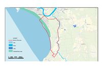 Reiu-Raeküla Blue infrastructure
 -
 Reiu-Raeküla Green infrastructure


Actors and stakeholders
- Who is driving changes in this landscape? Who is affected by those changes?
- Draw a stakeholder and/or power map: Who is affected highly but with low power? Who has high power but is not affected?
-
add a caption
Sacred spaces and heritage
- Which places/elements hold cultural value and to whom?
- You may add a map and some images, please also explain in your caption why these elements are valuable
-
add a caption
-
add a caption
-
add a caption
Visual appearance and landscape narrative
- Which elements are essential for the landscape character?
- Has the landscape been painted or otherwise depicted, when and whom? Which elements are essential?
- Which narratives exist? Who has written about this landscape or depicted it in some way?
- You can add text and images
-
add a caption
-
add a caption
-
add a caption
A.2 Summary of your landscape system analysis and your development targets
- You can summarize your findings with an DPSI(R) Model or a Spider Diagram
- Link back to the Sustainable Development Goals: Which goals are at risk?
- What is your hypothesis for this landscape?
- Visualise your hypothesis with one graphic/pict
- Are there any existing initiatives taking action in this landscape? Do you have a critical perspective on that?
- Add text and visuals
-
explain your analysis briefly in the caption
-
explain your hypthesis briefly in the caption
A.3 Theory reflection
- Reflect on at least three international policy documents in relation to their local landscape case
- choose one international, one European and one national document
- You can choose references from our reading list
- Scope: 250 words
A.4 References
- give a full list of the references you have used for this section
Phase B: Landscape Evaluation and Assessment
B.1 Assessment Strategy
- Based on the hypothesis derived from your previous landscape systems analysis you are now asked to define the goals for assessing the landscape. Your assessment is the basis for evaluating the landscape status.
- Which elements and phenomena need to be mapped, why and how?
- This a text contribution, max 250 words
B.2 Mapping
- As defined by your assessment strategy you conduct the mapping and present your findings here
- As a minimum, at least three different themes need to be mapped, you may choose more if needed
-
briefly explain the findings of your mapping
-
briefly explain the findings of your mapping
-
briefly explain the findings of your mapping
B.3 Problem definition and priority setting
- Give a summary of the major findings of your mapping process, what are the problems/potentials identified?
- Draw a problems/potentials map
- Set priorities for the most relevant issues
-
add caption here
B.4 Theory reflection
- Please reflect the assessment and evaluation methods used based on at least three readings
- Did you encounter limitations'
- 200 words test contribution
B.5 References
- give a full list of the references you have used for this section
Phase C – Strategy and Master Plan
C.1 Goal Setting
- Define strategic planning objectives based on the evaluation findings
- Link back to your original targets from section one and the Development Goals
- 150 words text contribution
C.2 Spatial Strategy and Transect
- translate your strategic goals into a vision
- develop a spatial translation of your vision
- exemplify your vision in the form of a transect with concrete interventions
- add map(s) and visualizations
-
add caption here
-
add caption here
-
add caption here
-
add caption here
C.3 From Theory of Change to Implementation
- For implementing your vision: Which partnerships are needed? Which governance model is required?
- Who needs to act and how? Draw and explain a change/process model/timeline
- Which resources are needed? On which assets can you build?
- add 150 words text and visuals
-
add caption here
-
add caption here
C.4 References
- give a full list of the references you have used for this section
D. Process Reflection
- Reflect in your intercultural and interdisciplinary team on the outcomes of your study
- Which limitations were you facing?
- What have you learnt from each other?
- What would you do differently next time?
- You can also use diagrams/visuals
- 250 words text