COLAND Case Study 2020 - De Panne: Difference between revisions
| Line 41: | Line 41: | ||
== A.1 Landscape layers and their system context == | == A.1 Landscape layers and their system context == | ||
=== Geomorphology, landscape units and coastal typology === | === Geomorphology, landscape units and coastal typology === | ||
Geomorphology: | |||
De Panne coastline consists of broad gently sloping sandy beaches with rows of dunes, former mudflats and salt marshes behind the dunes has been turned into polders. On the North Sea shallow continental shelf the Flemish Banks sandbanks occur. The natural beach sediments are mostly fine to medium size quartz grains. The Dunes consist of a mosaic of bare sand areas, dry, moist and wet grassland, shrub and initial dune forest. | |||
Evolution: | |||
After the melting of the North European Ice Cap the sea level started to rise (10 000 years ago) and regularly flooded flat areas sheltered by the coastal barrier. Holocene sand and clay deposited on tidal flats formed the dunes. Ongoing floodings triggered the formation of base peat where again sediments were deposited. This pattern reoccurred several times and formed the old dunes. About 3000 years ago a new dune chain was formed and old dunes disappeared. | |||
Drivers of Change: | |||
Natural interaction between the beach and the coastal dunes has been disrupted by several centuries of anthropogenic activities, the natural evolution of the coastline would be long term erosion and landward retreat. Marine processes - water level and waves erode dune toes, almost every winter sand is washed away and shoreline decreased. Regular maintenance nourishments are executed by the Coastal Division to repair this damage. | |||
<gallery caption=" " widths="200px" heights="150px" perrow="5"> | <gallery caption=" " widths="200px" heights="150px" perrow="5"> | ||
Revision as of 11:53, 20 February 2020
>>>back to working groups overview
| Area | Case Study 4: De Panne | |
| Place | De Panne | |
| Country | Belgium | |
| Topics | Coastal management, Tourism, Protected areas, Biodiversity, Dune systems, Sustainability, Seasonability | |
| Author(s) | Papa Smurf, Dumitru Chifa, Elina Õunsaar, Amanuel Workneh, Ajayi Olusegun | |

| ||
| Leopold I Monument | ||
Rationale
A tourist target area with an extremely floating population, with high movement during the balnear season and almost a desert during the cold season. Tourism can be extremely demanding on the land and coast even more in this particular area that is surrounded by Natura 2000 protected areas. Maintaining and protecting the natural landscape while tackling the need of assuring that the appeal for the tourist continues, considering a possibility of extending the tourism season through the year avoiding desertification and keeping some constante income flow and finally approaching the car issue that is quite intense in this area.
Location and scope
You can edit this map with the map editor
A Landscape System Analysis
A.1 Landscape layers and their system context
Geomorphology, landscape units and coastal typology
Geomorphology: De Panne coastline consists of broad gently sloping sandy beaches with rows of dunes, former mudflats and salt marshes behind the dunes has been turned into polders. On the North Sea shallow continental shelf the Flemish Banks sandbanks occur. The natural beach sediments are mostly fine to medium size quartz grains. The Dunes consist of a mosaic of bare sand areas, dry, moist and wet grassland, shrub and initial dune forest.
Evolution: After the melting of the North European Ice Cap the sea level started to rise (10 000 years ago) and regularly flooded flat areas sheltered by the coastal barrier. Holocene sand and clay deposited on tidal flats formed the dunes. Ongoing floodings triggered the formation of base peat where again sediments were deposited. This pattern reoccurred several times and formed the old dunes. About 3000 years ago a new dune chain was formed and old dunes disappeared.
Drivers of Change: Natural interaction between the beach and the coastal dunes has been disrupted by several centuries of anthropogenic activities, the natural evolution of the coastline would be long term erosion and landward retreat. Marine processes - water level and waves erode dune toes, almost every winter sand is washed away and shoreline decreased. Regular maintenance nourishments are executed by the Coastal Division to repair this damage.
-
add a caption
-
add a caption
Land use
De Panne mostly consists of discontinuous urban fabric and broad-leaved forest integrated with sand dunes. The area is a part of De Westhoek Flemish Nature Reserve (345 ha), which is the only area on the Flemish coast where nearly all dune vegetation is represented in one unbroken dune landscape. The main points of attraction in the area are two artificial breaks in the dunes, which should normally keep the sea at bay, so that the sea water penetrates into the nature reserve at high tide, making the vegetation and wildlife here particularly special.
Settlement in De Panne is quite dense, but gradually decreases as the city organically transitions into moors with low vegetation and sand dunes. Sand dunes and natural protection area limits the expansion of the building area, although there is also some sparse settlement near the beach and right on the border of the sand dunes.
The main infrastructure consists of three main roads that connect De Panne to other districts such as Duinhoek, Oosthoek and Saint-Idesbald. From the south, the area is bordered with another highway that connects it with France. There is also a 64km coastal tram line that goes along the N34, starting in De Panne and extending all the way to Knokke-Heist.
Non-irrigated arable land surrounds De Panne from the south, in the area itself there occurs no agricultural activity due to the moors and sands on the land cover.
In the last 30 years, the land use hasn’t changed, only a minor increase in settlements.
A great driving force in the area is tourism, as the beach area and Plopsaland De Panne theme park may be the main attraction, the De Westhoek natural reserve also plays an important role with its rich Flora, complemented by rare Fauna that might attract nature enthusiasts.
Severe climate changes and the sea level rise provoque an intensification of the coastal erosion and flood occurrences along all the Belgian coastline. These changes may force mass migration towards the interior since the coastline would not be suitable for the actual human activities.
-
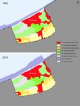 Land cover
 -
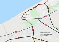 Road connections
 -
add a caption


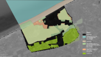
Green/blue infrastructure
The study area includes Natura 2000 birds and habitats directive sites which is a part of both the green and blue infrastructure. As the protected area is quite distributed with different peculiar landscape elements, the line between green corridor and blue infrastructure is interlacing and merging together.
The major green and blue infrastructure elements are moors and heathland, sparse forest area around the centre and sand dunes. The sea is a part of blue infrastructure along with dunes and ditches in between as they contribute to the water management of De Panne. Changes could occur in the green infrastructure as the building area may expand in the future. As most of the area is protected (Natuurreservaat de Westhoek), including the sand dunes, human activity is probably not a force of change. Due to climate changes the sand dunes and surroundings will most likely be flooded in the future, which is currently managed through the dunes on the south of the city. The area is also surrounded by the mixed agricultural fields. It is a more less organized kind of farm land and animal breeding area, with almost none industrial zones.
In addition to the the preserve areas and the sea, the inner city is integrated with small patches of green pocket spaces which gives relatively enough balance between the built urban setup and the natural environment.
-
 Green/Blue infrastructure
 -
add a caption

Actors and stakeholders
De panne is a region suited on the North Sea coast of the Belgian province of West Flanders. De Panne is a municipality with 10.153 citizens (NIS, 2007). It is known for its famous route called ‘Erfgoed wandeling’ (Heritage walking), Museum of Oceanic Coast and many sport activities designed for seniors. The unpredictable and dynamic nature of the de panne coastal area requires adaptable and straightforward basic leadership that grasp a diversity of knowledge and value. Thus stakeholder involvement in the environmental decision-making has been progressively looked for and embedded into national and international policy. So the involved stakeholders concerned with the national agencies through cross-ministerial units, research institutes, coastal user-groups including the tourism industry, coastal residents, local fishers, farmers, developers, sand mining companies, CBOS and NGOs will be involved at all stages of the project. These stakeholders will be involved and also the beneficiaries of the project.
-
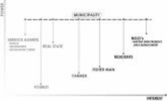 Power Map

Sacred spaces and heritage
Cultural heritage - Leopold I Monument
Leopold I memorial is designed by architect Victor Martiny and sculpted by René Cliquet. This monument made of Belgian bluestone and bronze in 1958 is located by sea opposite the Leopold I esplanade.
Leopold I (16 December 1790 – 10 December 1865) was a German prince who became the first King of the Belgians. 17 July 1831, the day that he first entered to independent Belgia in De Panne is commemorated annually as Belgian National Day. He was offered the position of king because of his diplomatic connections with royal houses across Europe. He reigned 34 years during which he encouraged economic modernisation, the creation of Belgium's first railway in 1835 and subsequent industrialisation. His diplomatic action helped to avoid the spread of the Revolutions of 1848 into Belgium and even slightly expand the monarch's powers during his reign.
Military heritage - Belgian Military Cemetery De Panne
The military graveyard is located close by the civil burial ground in De Panne. Altogether the site contains around 3370 Belgian war setbacks. De Panne is along these lines the biggest of all Belgian military burial grounds. It was started by battling units during the First World War. Afterward, graves from various smaller internment destinations in the Westhoek were moved here.
Architectural heritage - Dumont Quarter
The Dumont Quarter is an architectural heritage created between the late 19th and early 20th century under the direction of Belgian architect Albert Dumont. His eldest son Alexis Dumont is co-designer of many buildings and also drew up the plan of the “new De Panne” in 1902-1904.
This district has a unique construction plan with villas built in the style of rural cottages on top of the dunes with the respect for its existing surrounding environment. More modern villas were added later on. The Dumont Quarter has been protected since 1995. A memorial created by Alexis Dumont and Jules Lagae was erected in the district in 1926 for Albert Dumont.
Natural heritage - The Westhoek dunes The Westhoek dunes are part of 354 ha nature reserve right next to French border. The Westhoek dunes belong to the largest contiguous dune area of the Flemish coast and are protected as landscapes because of archeological and historical value. Area is the oldest Flemish state nature reserve, being under protection since 1935 and 1957. Dunes are characterized by the typical flora and fauna of moist hay and meadows. Also it is possible to observe the dynamic process of dune formation at the various stages of development and dune landscapes with a very different age, shape and vegetation.
-
add a caption
-
add a caption
-
add a caption
Visual appearance and landscape narrative
- Which elements are essential for the landscape character?
- Has the landscape been painted or otherwise depicted, when and whom? Which elements are essential?
- Which narratives exist? Who has written about this landscape or depicted it in some way?
- You can add text and images
-
add a caption
-
add a caption
-
add a caption
A.2 Summary of your landscape system analysis and your development targets
- You can summarize your findings with an DPSI(R) Model or a Spider Diagram
- Link back to the Sustainable Development Goals: Which goals are at risk?
- What is your hypothesis for this landscape?
- Visualise your hypothesis with one graphic/pict
- Are there any existing initiatives taking action in this landscape? Do you have a critical perspective on that?
- Add text and visuals
-
explain your analysis briefly in the caption
-
explain your hypthesis briefly in the caption
A.3 Theory reflection
- Reflect on at least three international policy documents in relation to their local landscape case
- choose one international, one European and one national document
- You can choose references from our reading list
- Scope: 250 words
A.4 References
- give a full list of the references you have used for this section
Phase B: Landscape Evaluation and Assessment
B.1 Assessment Strategy
- Based on the hypothesis derived from your previous landscape systems analysis you are now asked to define the goals for assessing the landscape. Your assessment is the basis for evaluating the landscape status.
- Which elements and phenomena need to be mapped, why and how?
- This a text contribution, max 250 words
B.2 Mapping
- As defined by your assessment strategy you conduct the mapping and present your findings here
- As a minimum, at least three different themes need to be mapped, you may choose more if needed
-
briefly explain the findings of your mapping
-
briefly explain the findings of your mapping
-
briefly explain the findings of your mapping
B.3 Problem definition and priority setting
- Give a summary of the major findings of your mapping process, what are the problems/potentials identified?
- Draw a problems/potentials map
- Set priorities for the most relevant issues
-
add caption here
B.4 Theory reflection
- Please reflect the assessment and evaluation methods used based on at least three readings
- Did you encounter limitations'
- 200 words test contribution
B.5 References
- give a full list of the references you have used for this section
Phase C – Strategy and Master Plan
C.1 Goal Setting
- Define strategic planning objectives based on the evaluation findings
- Link back to your original targets from section one and the Development Goals
- 150 words text contribution
C.2 Spatial Strategy and Transect
- translate your strategic goals into a vision
- develop a spatial translation of your vision
- exemplify your vision in the form of a transect with concrete interventions
- add map(s) and visualizations
-
add caption here
-
add caption here
-
add caption here
-
add caption here
C.3 From Theory of Change to Implementation
- For implementing your vision: Which partnerships are needed? Which governance model is required?
- Who needs to act and how? Draw and explain a change/process model/timeline
- Which resources are needed? On which assets can you build?
- add 150 words text and visuals
-
add caption here
-
add caption here
C.4 References
- give a full list of the references you have used for this section
D. Process Reflection
- Reflect in your intercultural and interdisciplinary team on the outcomes of your study
- Which limitations were you facing?
- What have you learnt from each other?
- What would you do differently next time?
- You can also use diagrams/visuals
- 250 words text