Novodari-Mamaia
>>>back to working groups overview
| Area | Workgroup 2: Năvodari-Mamaia | |
| Place | Năvodari, Mamaia | |
| Country | Romania | |
| Topics | Coastal landscape, Infrastructure and Development | |
| Author(s) | Mariana Bodea, Denisa Lungu, Gabriel Nicolescu, Antonia Panaitescu | |

| ||
Rationale
- Why do you think this case is relevant? What is your hypothesis considering the landscape challenges?
- Format: 3-4 sentences
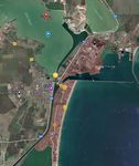
Location and scope
You can edit this map with the map editor
A Landscape System Analysis
A.1 Landscape layers and their system context
Geomorphology, landscape units and coastal typology
- Description of evolution, status quo and driving forces, is the coastal typology changing? Why is that? (approx 200 signs)
- add 1-2 graphical representations to the image gallery, you can add more if you like
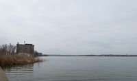
Navodari-Mamaia coast zone could be subdivided following the morphodynamic categories, with its very specific characteristics and behavior into a “Low, accumulative coasts mostly related to the main rivers mouth zones”. (classification made by National Institute of Marine Geology and Geo-ecology).
In Navodari-port area, we can find conglomerate limestones and siliceous limestones formed in the Mesozoic Era. In Mamaia area, we can find lumachella limestones formed in the Cenozoic Era.
Along the shoreline, from Navodari to Mamaia and between the sea and Siutghiol lake we can find marine deposits formed in Holocene period.
-
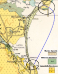 Coastal typology for Navodari-Mamaia area
 -
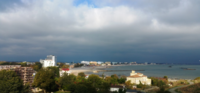 Mamaia beach area


Land use
PAST SITUATION
Năvodari town was mentioned for the first time in the 15th century, under the name "The Black Village". During the communist regime the town developed as part of the industrialization program. The main practices were industry, agriculture and housing. In 1957, in the area was built USAS (Uzina de Superfosfat si Acid Sulfuric, Superphosphate and Sulfuric Acid Factory), whose construction paved the road towards the industrialization of the area and demographic growth. In 1968 the population of Năvodari exceeded 6,500 inhabitants. A law adopted that year granted the commune of Năvodari town status and placed the Mamaia Sat village under its administration. The modernization of the town began in 1975 and finished on 29 June 1979.
CURRENT SITUATION
Today, Năvodari still has an important area that develops industry, as it is known for its important car repairs factory and a Petromidia factory specialized in petrochemical products. The town has also developed in the social and cultural fields. In the city center there is a children's town, built between 1969 and 1972, vacation accommodations, and sports facilities where up to 12,000 visitors can be accommodated. Some 5 kilometres from the town there is a summer camp(the largest one in Romania), built in the past for school children. Other activities such as: sport fishing, harbor, tourism, services, recreation, public spaces, educational activities, shipping and constructions.
-
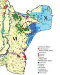 Distribution of the land use and land cover categories by major landform units 2006
 -
add a caption
-
add a caption

Green/blue infrastructure
- What are the major potential elements of a green/blue infrastructure network? Are these likely to change/disappear? Why is that?
- You find my background material on green infrastructure in our reading list
- add 1-2 graphical representations to the image gallery, you can add more if you like
In the context of an urbanised environment, green and blue infrastructure is to be understood as all natural and semi-natural landscape elements that (could) form a green-blue network. It can refer to landscape elements on various spatial scale levels: from individual rows of trees to complete valley systems. Examples of green landscape elements are hedgerows, copses, bushes, orchards, woodlands, natural grasslands and ecological parks. Blue landscape elements are linked to water. They can be pools, ponds and pond systems, wadis, artificial buffer basins or water courses. Together they form the green-blue infrastructure.
In Năvodari-Mamaia coastal zone the major potential elements of blue infrastructure network are Siutghiol Lake (with Ovidiu island), Tașaul Lake, Corbu Lake, Poarta Albă-Midia Năvodari Canal and Aqua Magic Park. The green infrastructure elements are reprezented by hedgerows, trees, bushes and natural grasslands. Năvodari City is also known for its many green spaces, the most important being Ion Dobre Park, The Central Park and The Jilava Park. This elements representing the green and blue infrastructure are unlikely to disappear in the near future because most of them are natural landscape elements. Also, this components are important for economic growth, tourism, recreational activities and industry.
-
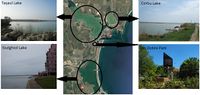 The main elements of the green-blue infrastructure in Năvodari-Mamaia coastal zone
 -
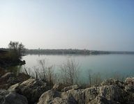
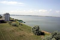
 Siutghiol Lake
 -
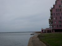 Siutghiol Lake
 -
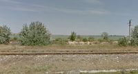 Corbu Lake (Google maps - Street View)
 -
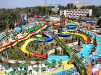 Aqua Magic Park
 -
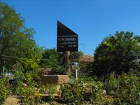
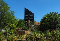 Ion Dobre Park


Actors and stakeholders
- Who is driving changes in this landscape? Who is affected by those changes?
- Draw a stakeholder and/or power map: Who is affected highly but with low power? Who has high power but is not affected?
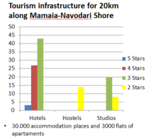
The shoreline between Mamaia and Navodari is the largest and most famous resort of the Romanian riviera. Mamaia has dealt in the last years with a vast process of modernization. All tourism infrastructure offer together about 30 thousand accommodation places. Besides hotels and studios, a strong concentration of residential buildings were built in the last years, which sum up almost 3 thousand apartments. Who is highly affected, and have no power to do something? The rapid development of the tourism infrastructure is shortening the beach and causes congestion. Beaches shortening is caused by the high rate of development in the area. Another problem is the heavy traffic during the summer among with noise and air pollution, caused by cars. The main persons affected directly by that are the residents that live here all the year, and indirect the tourists in the season.
-
 Mamaia-Navodari Area Power Map
 -
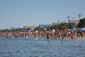 Beach congestion


Sacred spaces and heritage
- Which places/elements hold cultural value and to whom?
Symbolic spaces: Limanul Stiutghiol, Limanul Tașaul, Năvodari Beach, "Hanul Piraților" Beach, Ion Dobre Park, Sunshine Beach, main cliff of Năvodari, "Poarta Albă" Midia-Năvodari Canal, Insula Ostrov, Petromidia, Insula Ada, Fish Marker in Năvodari(negative symbol which was even closed), all Mamaia Village, restaurants such as Cherhanaua Tașaul, the walkway near the Mamaia Village, the dock of Mamaia. All these spaces elements hold symbolic meaning for the history of Năvodari or Mamaia, cultural reasons, for the citizens, the tourists or settlement. Places such as Cherhanaua Tașaul, the walkway near the Mamaia Village, the dock of Mamaia represent a symbol for people in a way of socializing, meeting places or landmarSpaces like "Poarta Albă" Midia-Năvodari Canal and Petromidia have an historical meaning and symbolise the main activities for Năvodari, also, the evolution and development of the area. For example, Poarta Albă is a symbol for the victims of communist, as it was a prison and labor camp attached to the construction of the Danube-Black Sea Canal.
-
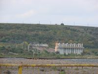 Canalul Poarta Albă-Midia Năvodari
 -
 Map-Location of sacred spaces and heritage
 -
 Lacul Tașaul- Isula Ostrov
 -
 Lacul Tașaul- Isula Siutghiol
 -
 Parcul Ion Dobre


Visual appearance and landscape narrative
- Which elements are essential for the landscape character?
The particularity of both Năvodari and Mamaia is their relation to the water. Being surrounded at the eastern side by the Black Sea and at the western side by Lake Siutghiol (Mamaia) or by Lake Tașaul (Năvodari), they act like barrier islands. This caracter is more visibile in the case of Mamaia, where the land is much narrower than it is in Năvodari. However, what strikes the visitor is the length of the beach in Mamaia, and also the slow slope of the shore when they enter the sea.
- Has the landscape been painted or otherwise depicted, when and whom? Which elements are essential?
- Which narratives exist? Who has written about this landscape or depicted it in some way?
Between the two settlements, Mamaia is the most popular, as from the beginning (in 1906) it was created as a seaside resort town - in contrast to Năvodari, which only became a touristic destination in the 1970s. Since 1906, Mamaia has been intensely promoted - first as the pearl of the Royal Romanian family and then, in the 60s and 70s as one of the great achievements of the communist systematisation program of the Romanian seaside. Being connected to the construction of the Danube-Black Sea Canal, Mamaia was also promoted through communist propaganda - postcards, artistic films and even books like Petru Dumitru's 1951 novel Drum fără pulbere [Road without Dust]
"He held his hands on the crane's command levers and moved them slightly and all of a sudden the block of stone started to swing in the air, with all its ten tons. [...] The crane pivoted, stretched its arm, and deposited the block in one of the wagons. [...] In the distance, the (Siutghiol Lake) shined. On its shimmering surface floated black caiques with curved bows, like Turkish slippers."
Even though less attractive than Mangalia or Balchik to painters and writers, Mamaia can as well be found as the subject of interwar period paintings.

Iosif Iser - "At the seaside", 1936, watercolor and ink on paper
-
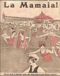 Advertising poster for Mamaia from 1912
 -
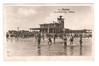 Postcard from 1935 showing the Mamaia casino building and the beach
 -
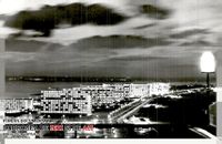 Postcard from 1965 showing Mamaia by night
 -
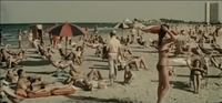 Still from the 1962 propaganda film "Vacanță la mare" ("Holiday at the seaside") showing the beach in Mamaia


A.2 Summary of you landscape system analysis and your development Targets
- You can summarize your findings with an DPSI(R) Model or a Spider Diagram
- Link back to the Sustainable Development Goals: Which goals are at risk?
- What is your hypothesis for this landscape?
- Visualise your hypothesis with one graphic/pict
- Are there any existing initiatives taking action in this landscape? Do you have a critical perspective on that?
- Add text and visuals
-
explain your analysis briefly in the caption
-
explain your hypthesis briefly in the caption
A.3 Theory reflection
- Reflect on at least three international policy documents in relation to their local landscape case
- choose one international, one European and one national document
- You can choose references from our reading list
- Scope: 250 words
A.4 References
- give a full list of the references you have used for this section
Phase B: Landscape Evaluation and Assessment
B.1 Assessment Strategy
- Based on the hypothesis derived from your previous landscape systems analysis you are now asked to define the goals for assessing the landscape. Your assessment is the basis for evaluating the landscape status.
- Which elements and phenomena need to be mapped, why and how?
- This a text contribution, max 250 words
B.2 Mapping
- As defined by your assessment strategy you conduct the mapping and present your findings here
- As a minimum, at least three different themes need to be mapped, you may choose more if needed
-
briefly explain the findings of your mapping
-
briefly explain the findings of your mapping
-
briefly explain the findings of your mapping
B.3 Problem definition and priority setting
- Give a summary of the major findings of your mapping process, what are the problems/potentials identified?
- Draw a problems/potentials map
- Set priorities for the most relevant issues
-
add caption here
B.4 Theory reflection
- Please reflect the assessment and evaluation methods used based on at least three readings
- Did you encounter limitations'
- 200 words test contribution
B.5 References
- give a full list of the references you have used for this section
Phase C – Strategy and Master Plan
C.1 Goal Setting
- Define strategic planning objectives based on the evaluation findings
- Link back to your original targets from section one and the Development Goals
- 150 words text contribution
C.2 Spatial Strategy and Transect
- translate your strategic goals into a vision
- develop a spatial translation of your vision
- exemplify your vision in the form of a transect with concrete interventions
- add map(s) and visualizations
-
add caption here
-
add caption here
-
add caption here
-
add caption here
C.3 From Theory of Change to Implementation
- For implementing your vision: Which partnerships are needed? Which governance model is required?
- Who needs to act and how? Draw and explain a change/process model/timeline
- Which resources are needed? On which assets can you build?
- add 150 words text and visuals
-
add caption here
-
add caption here
C.4 References
- give a full list of the references you have used for this section
D. Process Reflection
- Reflect in your intercultural and interdisciplinary team on the outcomes of your study
- Which limitations were you facing?
- What have you learnt from each other?
- What would you do differently next time?
- You can also use diagrams/visuals
- 250 words text