Aqaba Gulf
>>>back to working groups overview
| Area | Aqaba Gulf | |
| Place | Aqaba | |
| Country | Jordan | |
| Topics | Tourism Industry | |
| Author(s) | Mohammad, Nawar & Reem | |

| ||
Rationale
- Aqaba is a primary tourist destination for locals and foreigners and one of the key diving locations in the world, due to its world-known coral reefs. In addition, the Gulf of Aqaba is the only seaport in the country of Jordan, which led to the presence of international trade in the area. Moreover, it is considered as international waters with Israel which is raising political conflicts and competitions in tourism strategies in the past few years. These factors are demanding and leading to an accelerating economic development to transform the area into a sustainable economic growth and touristic engine for the country, leaving heavy pressures on the coastal landscapes in the area, and as a result, it has raised our curiosity to understand the coastal landscape management plan in the area.
Location and scope
You can edit this map with the map editor
A Landscape System Analysis
A.1 Landscape layers and their system context
Geomorphology, landscape units and coastal typology
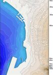
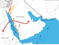
The Gulf of Aqaba (GOA) is one of the two waterways that originate from the northern margin of the Red Sea, which is about 165 kilometers long, with an average width of 20 kilometers and 800 meters deep. It is also a developing rift at the southern end of the dead sea transform system. The whole structure is a part of the Syrian–African rift valley, which is flanked by a mixture of mountains and deserts both to the east and the west. The southern end of this important waterway is separated from the Red Sea by a shallow sill at the Straits of Tiran. The Fossil reefs indicate that in the past 7000 Years the Red Sea level was stable and vertical tectonic movements were negligible. Geological Studies indicate sedimentary structures from two trenches dug in beach sediments buried and emerged fossil reefs and the local submarine slope morphology. The GOA has been subject to rapid changes due to the Urban and industrial expansions, as well as, the dramatic appearance of Touristic resorts along the shoreline.
-
 The Earliest Settlement was for the sake of Trade with the country of Eygpt and neighboring countries.
 -
 add a caption
 -
 add a caption
 -
add a caption
-
add a caption
-
add a caption
-
add a caption


Land use
- settlements, infrastructure, agriculture, resource extraction, natural areas, energy production...
- description of evolution, status quo and driving forces, is the land use likely to change? Why is that? (approx 200 signs)
- add 1-2 graphical representations to the image gallery, you can add more if you like
-
add a caption
-
add a caption
-
add a caption
-
add a caption
-
add a caption
Green/blue infrastructure
- What are the major potential elements of a green/blue infrastructure network? Are these likely to change/disappear? Why is that?
- You find my background material on green infrastructure in our reading list
- add 1-2 graphical representations to the image gallery, you can add more if you like
-
add a caption
-
add a caption
Actors and stakeholders
- The main driving forces behind the change of the Landscape in Aqaba are the Aqaba Special Economic Zone (ASEZA) which is the main authority body in the city, as well as, the investors and the shareholders who are dramatically investing in the Recreational and Touristic sector. Local residents are the most affected by these changes since all the public beaches are now being transformed into 5 Stars resort beaches, which can only be used by the resorts' guests.
-
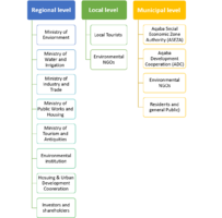 This Diagram illustrates the Stakeholders on the Regional, Municipal and local levels, and it is important to mention that the Aqaba Special Economic Zone Authority (ASEZA) acts as a separate authority body, whereas other ministries act on a Regional level.
 -
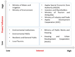 This Powermap demonstrates the interested parties and their power in terms of Touristic and Recreational developments taking place in Aqaba city
 -
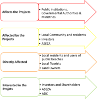 This Diagram also represents the Stakeholders but in terms of the level of impact and effect.


Sacred spaces and heritage
- Which places/elements hold cultural value and to whom?
- You may add a map and some images, please also explain in your caption why these elements are valuable
-
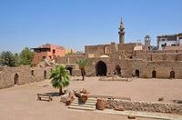 Mamluk Castle or Aqaba Fortress, a 16th century partially built castle that served as a military site and caravanserai for traveling pilgrims to Mecca. A castle that dates back to the Arab revolt time.
 -
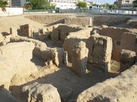 Aqaba Church is the world's oldest purpose-built Christian church dating back to the third century. One of the last destinations that tourists usually make a visit to after their route that starts all the way from Wadi Rum
 -
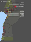 A map that shows the Roman, Byzantine, Mamlouk and Islamic Heritage sites that are valuable landscape elements for the locals


Visual appearance and landscape narrative
- Which elements are essential for the landscape character?
- Has the landscape been painted or otherwise depicted, when and whom? Which elements are essential?
- Which narratives exist? Who has written about this landscape or depicted it in some way?
- You can add text and images
-
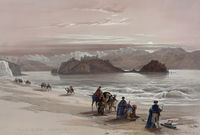 Isle of Graia Gulf of Akabah Arabia Petraea, 1839 lithograph of a trade caravan by Louis Haghe from an original by David Roberts. The painting depicts the desert like coastal landscape that is very special and related to the region. Showing the rocky mountains which are famous in Jordan's desert as well as Aqaba's background from the coast. The choice of brown tone colors to make the desert-like coastal landscape more vivid brings the atmosphere closer to the imagination.
 -
 Trade along the red sea has happened as early as the fourth Egyptian Dynasty. The early homo sapiens have also always taken the coastal routes due to the coastal resources and proof to that is the presence of the many archaeological sites located along the entire edge of the Red Sea Rift, starting from the very northern gulf of Aqaba up until the most southern African parts
 -
 The ancient city of Ayla (in present-day Aqaba) was a commercial hub for the Nabateans. The Romans built the Via Traiana Nova, which joined the King's Highway at Aqaba and connected Africa to Asia and the Levant and Red Sea shipping.
.jpg)


A.2 Summary of you landscape system analysis and your development Targets
- You can summarize your findings with an DPSI(R) Model or a Spider Diagram
- Link back to the Sustainable Development Goals: Which goals are at risk?
- What is your hypothesis for this landscape?
- Visualise your hypothesis with one graphic/pict
- Are there any existing initiatives taking action in this landscape? Do you have a critical perspective on that?
- Add text and visuals
-
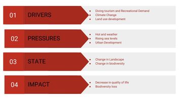 The most important drivers in Aqaba's landscape are the increasing tourism demands that are formulating in forms of fancy resorts and huge projects that put a lot of pressure on the biodiversity in the region as well as the land use development that of course follows the previous driver. Climate change is a huge driver that is also causing rising in sea levels and increasing evaporation, needless to mention that the evaporation rates in the red sea are the highest in the world. The pressures of the hot arid weather, the rising sea levels and the urban development are resulting in landscape and biodiversity change and the impact could be a huge loss of biodiversity. The Gulf of Aqaba's coral reefs are under a lot of risk, they are also known world-wide for the variety and beauty. Another impact of course is the decrease in the quality of life of the locals.
.jpg)
-
explain your hypthesis briefly in the caption
A.3 Theory reflection
- Reflect on at least three international policy documents in relation to their local landscape case
- choose one international, one European and one national document
- You can choose references from our reading list
- Scope: 250 words
A.4 References
- give a full list of the references you have used for this section
Phase B: Landscape Evaluation and Assessment
B.1 Assessment Strategy
- Based on the hypothesis derived from your previous landscape systems analysis you are now asked to define the goals for assessing the landscape. Your assessment is the basis for evaluating the landscape status.
- Which elements and phenomena need to be mapped, why and how?
- This a text contribution, max 250 words
B.2 Mapping
- As defined by your assessment strategy you conduct the mapping and present your findings here
- As a minimum, at least three different themes need to be mapped, you may choose more if needed
-
briefly explain the findings of your mapping
-
briefly explain the findings of your mapping
-
briefly explain the findings of your mapping
B.3 Problem definition and priority setting
- Give a summary of the major findings of your mapping process, what are the problems/potentials identified?
- Draw a problems/potentials map
- Set priorities for the most relevant issues
-
add caption here
B.4 Theory reflection
- Please reflect the assessment and evaluation methods used based on at least three readings
- Did you encounter limitations'
- 200 words test contribution
B.5 References
- give a full list of the references you have used for this section
Phase C – Strategy and Master Plan
C.1 Goal Setting
- Define strategic planning objectives based on the evaluation findings
- Link back to your original targets from section one and the Development Goals
- 150 words text contribution
C.2 Spatial Strategy and Transect
- translate your strategic goals into a vision
- develop a spatial translation of your vision
- exemplify your vision in the form of a transect with concrete interventions
- add map(s) and visualizations
-
add caption here
-
add caption here
-
add caption here
-
add caption here
C.3 From Theory of Change to Implementation
- For implementing your vision: Which partnerships are needed? Which governance model is required?
- Who needs to act and how? Draw and explain a change/process model/timeline
- Which resources are needed? On which assets can you build?
- add 150 words text and visuals
-
add caption here
-
add caption here
C.4 References
- give a full list of the references you have used for this section
D. Process Reflection
- Reflect in your intercultural and interdisciplinary team on the outcomes of your study
- Which limitations were you facing?
- What have you learnt from each other?
- What would you do differently next time?
- You can also use diagrams/visuals
- 250 words text